Introduction
Abbotsbury Gardens is a late-19th-century 'sub-tropical' garden, which originally covered 7 hectares and containing an extensive subtropical and Mediterranean plant collection first started by the third and fourth Earls of Ilchester, and further expanded in the late 20th century. The gardens were much restored in the 1970s and expanded by a further 8 hectares in the 1980s.
Terrain
The site lies in a sheltered valley, through which runs a small stream.The following is from the Register of Parks and Gardens of Special Historic Interest. For the most up-to-date Register entry, please visit The National Heritage List for England (NHLE):
Location, Area, Boundaries, Landform and Setting
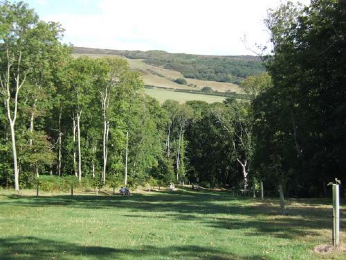
Abbotsbury Gardens, a site of c 15ha, is situated c 2.5km to the south-west of the village of Abbotsbury, on the Dorset coast. The site lies in a sheltered valley, through which runs a small stream. The Gardens are protected from frost and wind by the hills north of Abbotsbury village, the warming effect from the sea, and the windbreaks of holm oak and other trees. To the north the site is bounded by fields, and to the west by Buller's Way. To the south lies Peasons Plantations, surrounded by a belt of medieval strip lynchets, and to the east are further fields with strip lynchets. St Catherine's Chapel, on Chapel Hill in the distance to the east, forms an eyecatcher from within the Gardens.
Entrances and Approaches
The main approach to Abbotsbury Gardens is Buller's Way, which runs along the north-west boundary of the site and is lined by mature oak trees. Approaching from Abbotsbury to the north-east, there are three entrances to the Gardens along the east side of Buller's Way. The first is a service entrance (late C20), where gates give access to the northern part of the site. Further south is the main visitors' entrance, introduced in the late C20. Here, a pair of gates hung between natural stone gate piers gives access to a small forecourt leading to a plant sales and children's play area and a shop.
Access to the Gardens is through the shop, into the walled garden from where a footpath leads to the surrounding garden areas. The third entrance, called West Gate, is situated further south, at the west corner of the site. Wooden gates (late C20) give access to the West Drive, a straight path that runs through the Gardens in an easterly direction. This entrance was, during the C19, the main entrance to the Gardens (OS 1888).
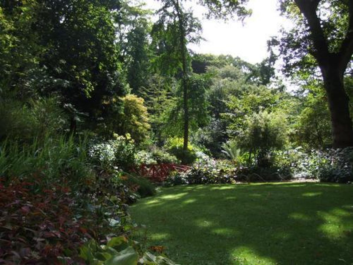
Gardens and Pleasure Grounds
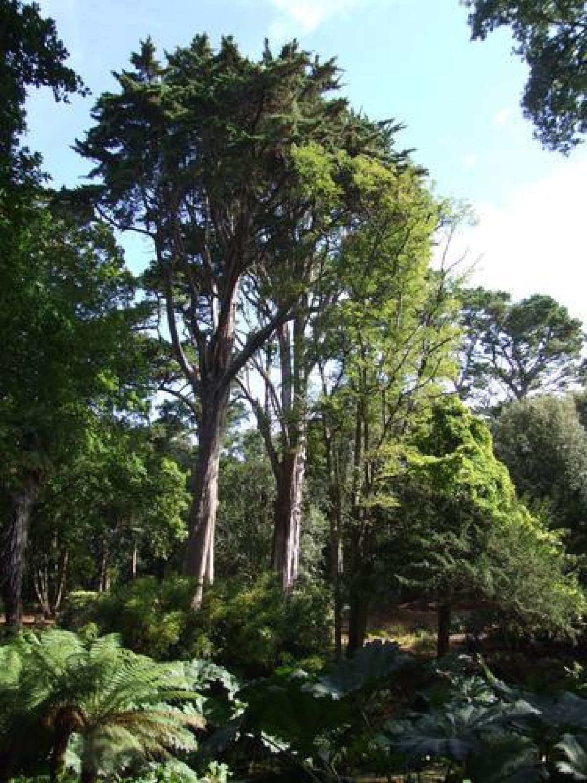
The Gardens are situated in the eastern part of the site along both sides of the stream in the valley. They enclose the walled garden and extend southwards into Stavordale Wood. A network of paths and walks extends through the site, the main ones being the West Drive (OS 1888) and the Upper and Lower Valley Walk (OS 1902). The various smaller paths lead to themed garden areas containing plants from the Mediterranean, Mexico, New Zealand, and the Far East.
In the west corner of the site is the West Lawn, which was created by 1886 (OS 1888). It is bounded to the south by the West Drive and to the east by the west wall of the walled garden which has a herbaceous border along its full length. In the centre of the West Lawn stands a conservatory, introduced in 1985, with to its north-east the graves of the Strangways family's dogs. The entrance to the conservatory is flanked by two cannon which during the late C18 stood in front of Strangways Castle (Plan of Strangways Castle, late C18). West of the lawn is a plantation of mixed pines and deciduous trees introduced in the late 1990s, replacing a wood of holm oak.
The West Drive, situated along the south side of the West Lawn, runs in an easterly direction and is flanked by rhododendrons, New Zealand satin flowers, and a magnolia planted in 1908 (guidebook). The West Drive leads into the valley with the stream and ponds. The south bank of the valley contains medieval strip lynchets and overlooks an area called the Himalayan Glade (introduced in the mid 1980s) situated in the valley below. A gazebo (late 1990s) situated along Coppice Walk, one of the paths on the southern bank of the valley, offers fine views of the Himalayan Glade and of St Catherine's Chapel situated in the far distance to the east of the site (outside the area here registered).
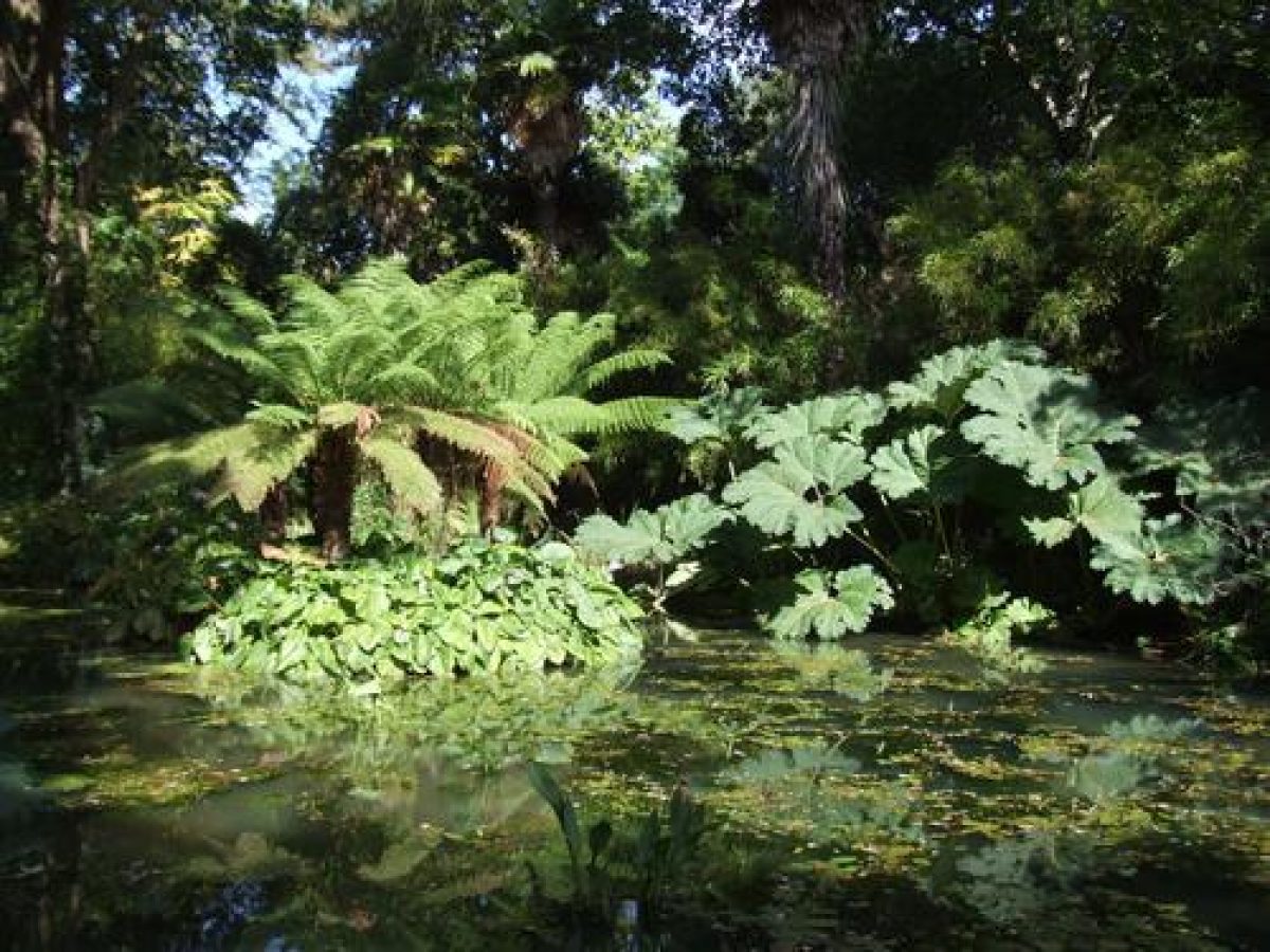
The Himalayan Glade leads to the Lower Valley Walk which runs along the east side of the stream in the valley. The stream, crossed by six bridges, links three ponds called Lower, Middle and Upper Pond, created in the late 1890s. The stream, ponds, and weirs have recently (mid 1980s and late 1990s) been restored and new wooden bridges introduced, replacing former late C19 rustic bridges (CL 1899). The planting along the stream is currently (2000) dominated by Gunnera manicata, a jungle plant from southern Brazil, and different varieties of bamboo. The lower part of the valley, towards the eastern boundary of the site, is planted with a variety of hydrangeas. Coronation Walk, situated in this area, offers views of the valley below to the south.
The upper part of the valley, which is bounded to the south by the Upper Valley Walk, is dominated by the Long Walk with, to its west, the New Zealand Garden, introduced in the late 1990s, replacing a former Rose Garden. To the east is an orchard with an herbaceous border. Immediately to the west of the New Zealand Garden are two formal lily ponds, first introduced in 1896-7 for irrigation purposes (ibid) and restored and replanted in the late 1990s. South of the ponds, steps lead down the Mediterranean Bank, an area replanted in the late 1990s. From the Mediterranean Bank a path leads in a southerly direction passing an aviary (late C20) and a bothy, both attached to the east wall of the walled garden.
The rectangular walled garden with attached bothy, mostly dating from the late C18 (listed grade II), is situated in the north-west part of the site. The northern half of the walled garden is dominated by a restaurant with tea garden, introduced in the late 1990s and built partly on the site of glasshouses that formerly stood here (OS 1902). Immediately to its east, situated on a lower level with a retaining wall to its south and east, is the rectangular Sunken Garden. This can be accessed by steps through the north garden wall. The Sunken Garden is laid to lawn, with in the centre a row of palm trees, and is lined by a perimeter walk with seats. The outline of the area covered by the Sunken Garden is first shown on the 2nd edition OS map surveyed in 1901.
In the south-east corner of the open-air terrace in front of the restaurant is a small ticket kiosk (late 1990s) from where a path leads to the Victorian Garden which occupies the southern half of the walled garden. This has a semi-formal layout containing a central bed, surrounded by a collection of late C19 Chusan palm trees. Below the latter are mixed borders, planted in the summer with subtropical bedding plants. The C18 bothy, attached to the outside of the east garden wall, has been restored in the late 1990s and houses a display of Victorian garden tools and late C19 photographs of Abbotsbury Gardens.
The walled garden, which may have been the kitchen garden to Strangways Castle, is first shown on an early C19 estate plan, probably drawn after the Enclosure Act of 1814 (Plan of Abbotsbury, post 1814). By then it was mainly used for providing seed-beds for newly collected plants and for providing space for planting out (Poore 1997). By 1886 (OS 1888), the walled garden had a formal layout and a great variety of fruits was grown in it (Ilchester 1899; Gardeners' Chronicle 1899).
Maps
- Plan of Strangways Castle, Abbotsbury, late C18 (Dorset Record Office)
- Plan of Abbotsbury, post enclosure 1814 (Dorset Record Office)
- OS 6" to 1 mile:
- 1st edition surveyed 1886, published 1888
- 2nd edition revised 1901, published 1903
- OS 25" to 1 mile:
- 1st edition surveyed 1886, published 1888
- 2nd edition revised 1901, published 1902
Archival items
- Correspondence and related papers referring to Abbotsbury Gardens are held in private archives at Penrice Castle, Glamorgan, Wales and Lacock Abbey, Wiltshire
Description written: November 2000
Register Inspector: FDM
Edited: April 2005, May 2022
- Visitor Access, Directions & Contacts
Telephone
01305 871387Access contact details
The site is open 7 days a week throughout the year from 10am to 5pm. Online booking is advisable but not essential.
For more detailed visitor information visit the Abbotsbury Gardens website.
Directions
Leave the A35 west of Dorchester and follow the B3157 coast road.
- History
The following is from the Register of Parks and Gardens of Special Historic Interest. For the most up-to-date Register entry, please visit The National Heritage List for England (NHLE):
18th Century
Abbotsbury Gardens contain a late 18th century walled garden which was the kitchen garden of the former Strangways Castle, built by the first Earl of Ilchester (Poore 1997). The Castle was built in the late 18th century in a Gothic Revival style near Chesil Beach (outside the area here registered), about 850 metres to the west of the walled garden.
19th Century
During the first half of the 19th century, Henry Stephen Fox-Strangways, the third Earl of Ilchester, inherited the Abbotsbury estate. In 1808, he began enclosing open fields and commons situated within the estate, and three years later he planted Stavordale Wood, immediately east of the walled garden then known as Castle Gardens. In the early 19th century, the third Earl established, with the assistance of his younger half brother William Fox-Strangways, who was a keen botanist, an extensive plant collection in the Castle Gardens.
The Gardens were extended westwards into the fields outside the walls and into the valley along the northern edge of Stavordale Wood. William was able, through his postings abroad in the diplomatic service, to collect and bring back many exotic plant species and varieties. During this period, the Fox-Strangways family established, through marriage, close contacts with other plant collectors and gardeners, including Thomas Mansel Talbot of Penrice Castle, Glamorgan, the photographer and botanist Henry Fox-Talbot of Lacock Abbey, and also with members of the Digby family (Sherborne Castle and Minterne). Their correspondence (held mainly in the private archives at Penrice Castle and Lacock Abbey), provides references to specific species and varieties introduced at Abbotsbury Gardens.
After the third Earl of Ilchester's death in 1858, his brother William briefly succeeded as the fourth Earl until his death in 1865. During the 1860s he enlarged the Gardens further (Country Life 1899) and in 1865 appointed Peter McNeil as head gardener (Poore 1997).
During the 1890s, under the ownership of the fifth Earl of Ilchester and his wife Mary, the expansion of both the plant collection and the Gardens continued (Country Life 1899). They appointed Joseph Benbow as head gardener, who had previously worked for Sir Thomas Hanbury of Kingston Maurward, Dorset, in his garden at La Mortola in Northern Italy, created in 1867 (Gardeners' Chronicle 1899). It has been suggested that Benbow may have encouraged or influenced the fifth Earl and Countess in the creation of a subtropical, or rather Mediterranean garden, similar to that at La Mortola (Poore 1997). During this period, the Castle Gardens were extended to the north-east, more shelter belts were planted to the south-west, dams were installed along the stream in the valley, two lily ponds were created, and a new garden layout was introduced within the walled garden.
In 1899 Mary Ilchester published a catalogue for Abbotsbury Gardens, listing over 4000 different plant species and varieties from every continent. By 1912 the collection had expanded further to over 5000 species (Poore 1997; Gardeners' Chronicle 1912).
20th Century
After the First World War, Abbotsbury Gardens fell into decline, and it was not until the late 1960s that a programme of more active management began. This was instigated by the daughter of the seventh Earl of Ilchester and included, in 1982-1984, the further expansion of the Gardens into Stavordale Wood to house a Chinese plant collection. This phase of restoration and expansion has continued, and since the 1990s new plant collections and garden features have been introduced, as well as a shop, a restaurant, and a tea garden.
The site remains in private ownership.
- Features & Designations
Designations
The National Heritage List for England: Register of Parks and Gardens
- Reference: GD1698
- Grade: I
Features
- Stream
- Chapel
- Description: St Catherine's Chapel, on Chapel Hill in the distance to the east, forms an eyecatcher from within the Gardens.
- Castle (featured building)
- Now Demolished
- Description: The Castle was built in the late-18th century in a Gothic Revival style near Chesil Beach. It burnt down in 1913 and rebuilding works started immediately. The work was completed in 1916 but the new Castle was never occupied and was demolished in about 1935. Only the foundations now (2000) remain.
- Key Information
Type
Garden
Purpose
Ornamental
Principal Building
Parks, Gardens And Urban Spaces
Survival
Extant
Hectares
15
Open to the public
Yes
Civil Parish
Abbotsbury
- References
References
- {English Heritage Register of Parks and Gardens of Special Historic Interest} (Swindon: English Heritage 2008) [on CD-ROM] Historic England Register of Parks and Gardens of Special Historic Interest
- Holme, C {The Gardens of England in the Southern and Western Counties} (1907) pls 2, 3 The Gardens of England in the southern and western counties
- Poore, Andy {Abbotsbury Heritage Management Plan} (1996) Abbotsbury Heritage Management Plan
- (9 December 1899), pp 744-56 Country Life, 6
- Gloag, R., (1906), pp 47-56 A Book of English Gardens
- Paterson, A., (1978), pp 21-2 The Gardens of Britain 2: Dorset, Hampshire and the Isle of Wight
- Plumptre, G., (1985), pp 258-60 Collins Book of British Gardens
- Poore, A., (report for Ilchester Estates, 1997) Abbotsbury Gardens: Interim report
- Ilchester, M., (1899) Catalogue of Plants in Abbotsbury Gardens
- (19 August 1899), pp 142-3, 145; (20 July 1912), pp 44-5 M The Gardeners' Chronicle
- (Ilchester Estates 1997) Abbotsbury Subtropical Gardens, guidebook
- (2000) [issued annually by Ilchester Estates] Abbotsbury Subtropical Gardens, Plant List