Introduction
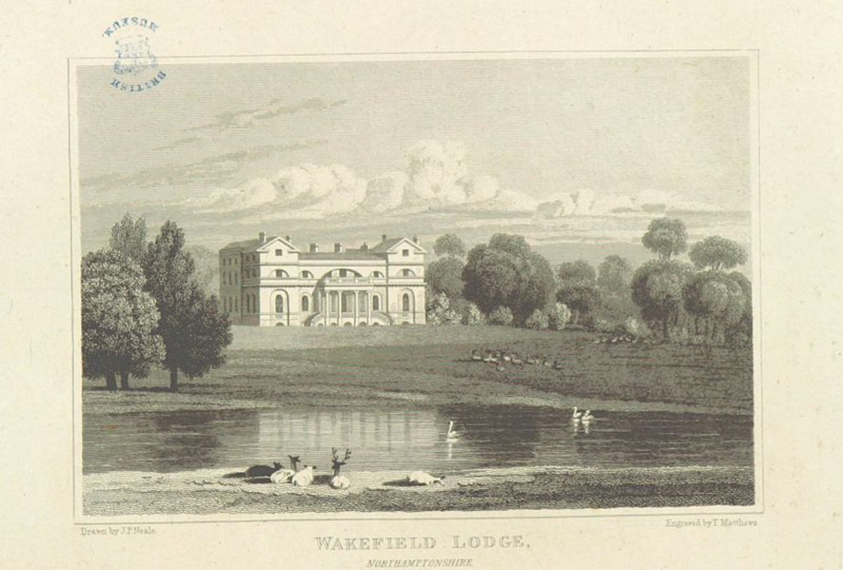
The planting on Wakefield Lawn has all but disappeared today, as almost the whole area is now under arable cultivation. Much of the house was demolished in 1948, but the wing by William Kent remains. The Victorian dairy farm and walled garden also survive, as does the formal ha-ha in front of the house.
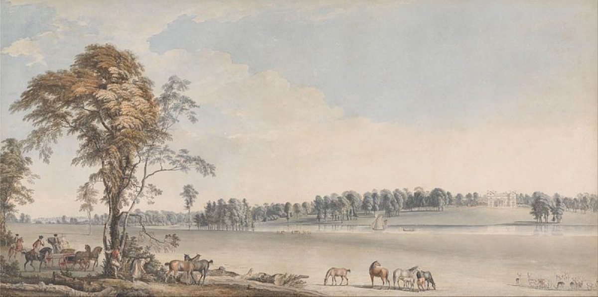
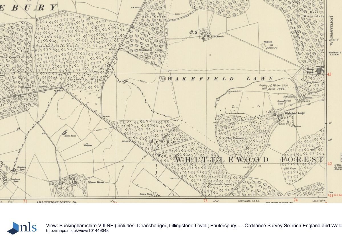
The planting on Wakefield Lawn, some of which was evidently enclosed, is shown on early edition OS maps and in paintings by Paul Sandby in 1767. It has all but disappeared today, as almost the whole area of Wakefield Lawn is now under arable cultivation. In 1985 The National Rivers Authority conducted a survey of Wakefield Lodge as part of their river corridor study. Whilst the historical details included are inaccurate, the survey provides a general picture as to the condition of the planting on the estate at that time.
Detailed description contributed by Northamptonshire Gardens Trust 20/08/2016
- History
Wakefield Lodge is located in the south of Northamptonshire (NGR SP 7375 4250), on the county boundary with Buckinghamshire, west of the Roman road called Watling Street (the current A5 trunk road), between Towcester and Stony Stratford. It lies about two miles west of the village of Potterspury, on a slight hill in a clearing within the ancient Royal Forest of Whittlewood. The house was first used as a hunting lodge, and appears to have become the official residence of the Lords Warden of the Forest on the desertion of the village of Puxley. Thus the history of the site through the medieval and post medieval periods indicates that Wakefield Lodge had a purely functional purpose and as such there may never have been much early formal ornamentation of the landscape.
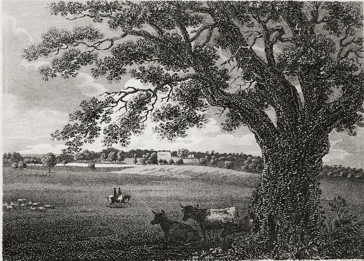
The conscious designing of the landscape seems to have started from the middle of the 18th century, and carried through into the 19th century when Victorian formality appears to have been appended to Lancelot ‘Capability' Brown's earlier landscaping. Although it had been cleared several centuries beforehand, Brown was initially credited with the 'creation' of the vast sweep of Wakefield Lawn to its encircling woodland; his work instead had been largely to enhance it, adding perspective and punctuating its expanse via his characteristic 'scattered' clumps of trees. His other main works comprise the creation of vistas through the surrounding woodland and two substantial lakes. The parkland was stocked with fallow deer from Petworth.
Wakefield Walk formed one large division of the six thousand acre medieval forest of Whittlewood. A deer park is first recorded in the vicinity of Wakefield Lodge in 1230. Together with Salcey Forest, Whittlewood Forest formed part of the Honor of Grafton which was created by Henry VIII in 1541. An enclosed, but unnamed park is shown on Saxton's map of 1576 and Speed's map of 1610. Further detail is provided by a map of Whittlewood Forest of around 1608 which shows the forest keeper's lodge as a large two-storey building to the south of a triangular medieval fishpond and overlooking the deer park lawn to the north; four and a half thousand acres of the original forest were still wooded at this time.
The most striking feature of Wakefield Walk was the large expanse of Wakefield Lawn. It was enlarged around 1600 by James I and at this time was also totally enveloped by woodland. Blocks of earthwork ridge and furrow cultivation have been traced on Wakefield Lawn, and have been associated perhaps with a medieval settlement at Wakefield. However, although the county historian John Bridges asserted the earlier presence of a settlement here no further evidence has been found and it is considered more likely that the ridge and furrow represents contemporary or later ploughing of the ancient deer lawn, possibly to improve the grassland. The lawn was overlooked by Wakefield Great Lodge, a royal hunting lodge which became successively the residence of the keeper, and then the lieutenant of the forest. The latter was traditionally allowed to keep just a few cattle and horses on Wakefield Lawn, but in the 1670s one Thomas Kingston was reported for making a considerable profit from the cattle he was rearing on the lawn. In 1691 the Surveyor General of Woods reported that a watchtower was required on Wakefield Lawn to prevent the illegal coursing of deer.
In about 1670 the Honor of Grafton was granted to Queen Catherine, with reversion to the Earl of Arlington. Following the queen's death in 1705 the Honor in fact passed to Arlington's grandson Charles Fitzroy, the Second duke of Grafton. Although the family's principal seat was at Euston in Suffolk, the duke was an avid huntsman, and he and his heirs were made Wardens of Whittlewood Forest from 1712.
A rebuilding of the hunting lodge is said to have been undertaken in the 17th century by John Claypole, the son-in-law of Oliver Cromwell. However, in 1747 the Second Duke commenced expensive improvements which would turn Wakefield into a handsome country seat for the dukes of Grafton. Research on this period of Wakefield's history has drawn heavily on documentary evidence from the Grafton Collection held at Northamptonshire Record Office. Estate accounts detail the building of William Kent's north wing extension to the earlier lodge, construction of the stables, and Brown's modelling of the landscape. They include labourers' worksheets, bills and vouchers, but unfortunately there is no commissioned plan for Brown's work at Wakefield: the first detailed map of the estate post-dating his work is a Forest survey dated 1787, and is part of the private collection held at Wakefield Lodge.
The duke was able to finance restoration of Wakefield Lodge with the assistance of a Treasury Grant, since the house was an official residence. Thus, a large northern wing designed by William Kent (who also built the Graftons' house at Euston), was added to the house in the late-1740s. The wing, with its portico, has been compared to Inigo Jones' Queen's House at Greenwich. Progress of the work on the building is well-documented; in the April of 1747 work began on the house and by December 1751 most of the work had been completed, although the workmen's final bills were not settled until August 1754. The commodious, red brick stable block on the east side of the house, facing the main approach to Wakefield Lodge was also built in 1747.
Lancelot Brown was engaged on landscaping at Wakefield Lodge following William Kent's death in 1748, having previously worked with Kent at nearby Stowe Park, and where Brown was still employed. In August 1749 estate accounts record Brown's Great Pond as being staked out by Robert Greening. This was achieved by substantial enlargement of the triangular medieval fishpond to the north of the house and would have been one of Brown's first commissions to lay out water. He built an enormous earth and stone dam in order to raise the water level in the valley by 25 feet. Later, in 1754 and to the east of this dam, he was to create another smaller lake (New Pond) which was fed by The Great Pond.
Works to the landscape in 1749 additionally included tree planting as beeches and Scotch firs were purchased from Richard Foster's nursery in Coventry. In the same year local carpenters are recorded as sharpening stakes for trees in the clumps on the lawn. In 1750 Brown himself bought in many more beech trees and had laurels sent over from Stowe where he still worked.
In 1750 labourers created the first of several vistas proposed by Brown, cutting a view through Hill Coppice from The Pheasantry to focus on the church spire at Hanslope. In addition, by cutting existing ridings broader through to Hallow's Brook two more vistas were opened to the villages of Grafton Regis and Potterspury. Also a road running from the Lodge through Steer Coppice was being metalled at his time, and in 1752 this road was being extended further eastwards to form the main approach from Potterspury.
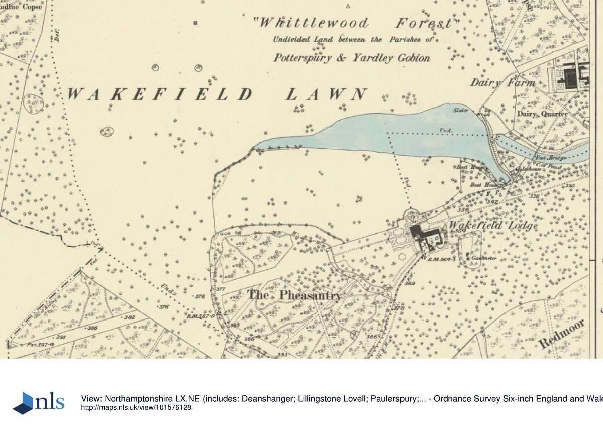
The earliest reliable map after Brown finished his landscaping at Wakefield was a survey of Whittlewood forest in 1787, commissioned by Parliament to establish the state and condition of the Crown's woods and forests, and their revenues. At the centre of the Wakefield Walk are the Lodge, lawn, stables, pheasantry, and gardens seen for the first time to the west and south of the house. Brown's early serpentine lake is clearly shown feeding into a second smaller one, with a drive crossing its dam on to the lawn. Clumps of trees can be seen on the lawn, and a building in a fenced enclosure called Wakefield Little Lodge, later (OS 1880s) referred to as The Kennels, now a private house. The map also clearly illustrates that the full effect of the 'new' house within its improved landscaping was presented from a series of circuitous drives around the parkland. Brown had also designed a woodland ride called The Belt, which afforded views of the house and parkland through the surrounding trees.
Horace Walpole is known to have visited Wakefield in 1751, shortly after the Second duke of Grafton's costly improvements had been made. Although by now the centre of a large country estate, Wakefield Lodge was still used primarily for hunting and associated entertainment. Accordingly, the earlier, pre-Kent, decaying parts of the main house were rebuilt in the 1770s by the Third duke of Grafton. The Wakefield Lawn Races were discontinued in 1788 only about twenty years after they had been initiated.
In the early-19th century Wakefield was described by the county historian George Baker as a lawn which was belted by stately woods with ridings which branched off in all directions into the heart of the forest. The rides are clearly visible on both the Forest map of 1787 and Bryant's map of 1827, and many are still traceable in the woodland today.
Since at least the late-18th century the main approach to the house, about a mile in length, has been made from a minor road off Watling Street to the east, opposite the village of Potterspury. The road also serves the remaining farms at Puxley, but the point at which the Wakefield Lodge approach diverges is clearly marked by the presence of a lodge house. The date and form of this building has not yet been identified. It is not shown on the 1787 Forest map, although a further structure is indicated where the approach enters Whittlewood Forest. This second structure, which still stands, is identified as a lodge on Bryant's map of 1827 but labelled Farm Yard and Dairy in 1787. The 1787 map also shows the main approach road leading to a long rectangular forecourt flanked to the south by the stables. For most of its length the course of the approach is long and straight; the clearance of trees by Brown in 1756 created a vista to open a view eastwards to Potterspury and Castlethorpe churches. The approach has recently been formalised by the planting of an avenue of trees.
Remnants of a more formal landscape survive at Wakefield, although insufficient evidence has hampered defining a date for these, and as yet no estate maps have been seen which would assist this process. However, the limited evidence of the county-based antiquarian mapping together with the evidence of early edition Ordnance Survey (OS) mapping suggests that this formality may largely have been a Victorian creation. Indeed, further substantial additions and alterations are known to have been made to the main house in the 19th century and it is quite likely that these would have been accompanied by modifications to the landscape.
Late-19th-century OS mapping indicates that a vista was created running for more than a mile westwards from the house, and on the same axis as the eastern approach road from Potterspury. This vista was achieved by the linear clearance of trees from the ancient forest. It is not shown on OS mapping of 1833, and is thus likely to represent mid-19th-century landscaping. Like the main approach, the western vista is emphasised today by a recently-planted avenue of trees.
Also surviving today is the symmetrical, semi-circular, formal ha-ha or terrace in front of the house. This feature is not recognisable on maps until the late-19th century, and may therefore represent another piece of mid-19th-century landscaping. (There is documentary evidence for a ha-ha having been built in 1758 between the house and the paddocks to the south of the Great Pond, however no physical evidence for this structure survives and it may have been removed by the later landscaping.) The centre-piece of this frontage to the house appears to have comprised a formal, hexagonal garden feature, which may still survive as a slight earthwork. Steps leading down the front of the ha-ha into the parkland gave access to a straight, tree-lined walk leading northwards to the banks of the main lake. The steps survive, but the path appears to have been removed recently.
The boundary of the terrace can be traced westwards around the house, where it encompasses a series of formal parterres, also possibly of mid-19th-century date. Interestingly, these parterres may replace an earlier formal garden on the same site which appears be shown on the 1833 OS map. The parterres survive as earthworks which are visible from aerial photography. Running through the centre of the parterres, and aligned with the westwards running 'avenue' is a straight walk which today runs as far as the boundary to the formal garden, but in the late-19th century extended well beyond into an informal woodland area called The Pheasantry. The path, at the end of which appears to have stood a statue or similar feature, then diverged into a series of winding walks around this woodland. OS maps indicate that the woodland was featureless other than a small circular pond at its northern end and a few remaining, earlier straight walks through it. It survives largely intact, although a small portion has been cleared of trees to the south of the avenue which bisects it.
Two icehouses are marked on the late-19th-century OS mapping. One, apparently a hexagonal structure, was located at the foot of Brown's dam to the north-east of the house, close to a pump house. It pre-dates Brown's landscaping, and accounts indicate that it was built between 1746 and 1748. The other, possibly later in date, is located within an enclosure somewhat closer to the house, behind the stables; this enclosure appears to have contained other essential service structures including a gasometer. Both icehouses appear on 1950s mapping, but there are no standing remains of either today.
A significant feature of the landscape is the new Dairy Farm to the north-east of the main house. Mapping suggests a Victorian date for both the farm and the nearby four-acre walled kitchen garden located to the east. Detailed accounts of both labourers and garden survive from the 1850s to the 1870s and include records of building the walled kitchen garden in the 1860s with a head gardener's house in the north-east corner. Water for the garden is supplied from a reservoir on the hill to the north. A late-19th-century OS map indicates the presence of a sundial within the boundary wall of the kitchen garden. A number of glasshouses and other buildings are shown around the outside walls of the garden. Some survive, but their current condition is uncertain.
Detailed history contributed by Northamptonshire Gardens Trust 20/08/2016
- Associated People
- Features & Designations
Features
- Ha-ha
- Description: Also surviving today is the symmetrical, semi-circular, formal ha-ha or terrace in front of the house.
- Steps
- Description: Steps leading down the front of the ha-ha.
- Parterre
- Description: The parterres survive as earthworks which are visible from aerial photography.
- Walk
- Description: Running through the centre of the parterres, and aligned with the westwards running 'avenue' is a straight walk which today runs as far as the boundary to the formal garden.
- Avenue
- Description: Like the main approach, the western vista is emphasised today by a recently-planted avenue of trees.
- Kitchen Garden
- Description: Mapping suggests a Victorian date for both the farm and the nearby four-acre walled kitchen garden located to the east.
- Gate Lodge
- Description: This structure, which still stands, is identified as a lodge on Bryant's map of 1827 but labelled Farm Yard and Dairy in 1787.
- Stable Block
- Description: The commodious, red brick stable block on the east side of the house, facing the main approach to Wakefield Lodge was built in 1747.
- Earliest Date:
- Latest Date:
- Approach
- Description: The approach has recently been formalised by the planting of an avenue of trees.
- House (featured building)
- Description: A large northern wing designed by William Kent was added to the house in the late-1740s. The rest of the house was demolished in 1948, but this wing survives.
- Earliest Date:
- Latest Date:
- Lake
- Description: In August 1749 estate accounts record Brown’s Great Pond as being staked out by Robert Greening. This was achieved by substantial enlargement of the triangular medieval fishpond to the north of the house and would have been one of Brown’s first commissions to lay out water.
- Earliest Date:
- Latest Date:
- Lake
- Description: Another smaller lake (New Pond) which was fed by The Great Pond.
- Earliest Date:
- Latest Date:
- Key Information
Type
Park
Purpose
Agriculture And Subsistence
Principal Building
Domestic / Residential
Survival
Part: standing remains
Civil Parish
Potterspury
- References
Contributors
Chris Addison
Rod Conlon