Introduction
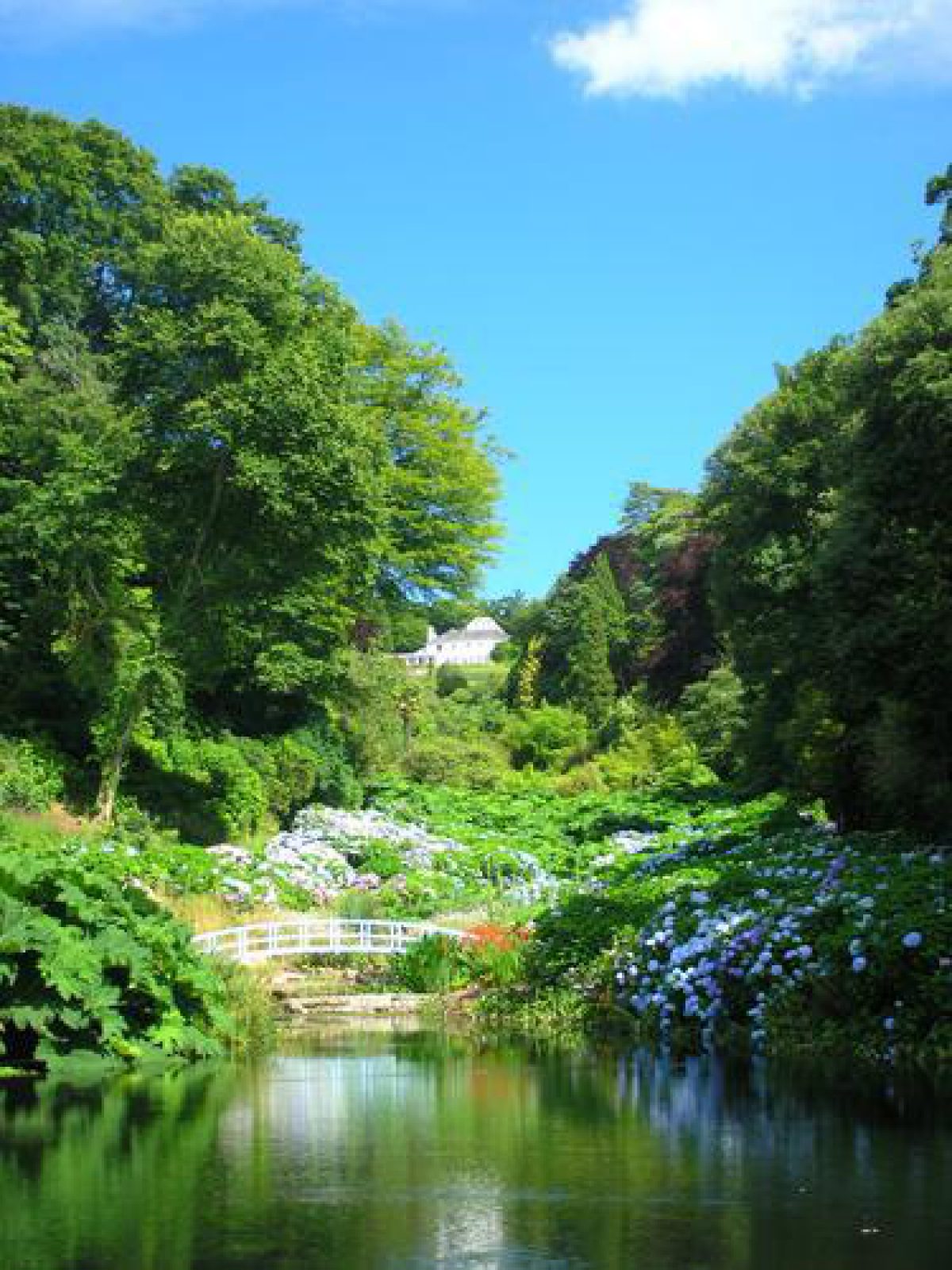
Trebah has 19th century woodland gardens occupying about 10.5 hectares on a steep-sided valley site. There are significant internal vistas within the site from walks on the east- and west-facing valley sides, with the house itself acting as an eyecatcher from lower areas of the valley.
Terrain
The site comprises a steep-sided valley which drops from the north to Polgwidden Cove which forms the south and south-east boundary on the Helford River.The following is from the Register of Parks and Gardens of Special Historic Interest. For the most up-to-date Register entry, please visit The National Heritage List for England (NHLE):
An early and mid 19th century woodland valley garden created by Charles Fox and developed in the late 19th and early 20th century with collections of rare and exotic plants.
Location, Area, Boundaries, Landform and Setting
Trebah is situated approximately 5km south-west of Falmouth and 2km south-west of the village of Mawnan Smith. The c 10ha site is bounded to the north by a minor road which runs south-west from Mawnan Smith to the ferry at Helford Passage, while to the north-east it adjoins the garden at Glendurgan (qv) for a short distance. To the east the site adjoins agricultural land, while to the west the boundary is formed by a track which leads south from the public road to Chycoose and Polgwidden Cove. The site comprises a steep-sided valley which drops from the north to Polgwidden Cove which forms the south and south-east boundary on the Helford River. There are significant southerly views through the garden to the Helford River and beyond to woodland near Bosahan. There are also significant internal vistas within the site from walks on the east- and west-facing valley sides, with the house itself acting as an eyecatcher from lower areas of the valley.
Entrances and Approaches
Trebah is approached from the minor road to the north at a point around 300m north-east of Trebah-wartha. The wide entrance is flanked by a pair of stone piers surmounted by ball finials, which are in turn flanked by stone quadrant walls surmounted by late 20th century white-painted timber railings. Within the site and immediately south-west of the entrance, an early 20th century two-storey stone lodge adjoins the drive; this lodge was constructed in about 1907 (OS; Pearson Assocs 1999).
The tarmac drive extends nearly 100m south-south-west from the entrance with mature evergreen shrubs and specimen conifers on a Cornish hedge to the west, and early 20th century metal estate fencing to the east allowing views from the drive across adjacent agricultural land to mature trees and conifers associated with Glendurgan. An entrance cut in the Cornish hedge leads to a late 20th century car park to the north of Trebah Farm. To the east of the farm the drive broadens to form an additional parking area, with further conifers and evergreen shrubbery screening the 19th and 20th century farm buildings. South of the car-parking areas the drive is gravelled, and sweeps south-west between banks of evergreen shrubbery and specimen trees which are retained by low rubble-stone walls.
A path leads south-east to the late 20th century visitors' entrance and facilities which are situated around 75m east of the house, while the main drive continues south-west to reach a gravelled carriage circle to the east of the house. Surrounded by lawns to the south-east and south, the carriage circle has a central circular raised bed planted with palms and specimen shrubs which is retained by a low random stone wall; the carriage court occupies the site of the mid 19th century villa built by Charles Fox. A service drive ascends north-west from the carriage circle to reach the service quarters to the north of the house, and the mid 19th century game larder (listed grade II) immediately west of the house. From the service buildings a gravelled drive extends c 190m west to join the public road at Trebah-wartha. The entrance from Trebah-wartha is marked by a pair of simple granite gate piers flanked by dressed granite walls. The west drive is continued to the north-east of the house by a path which forms the southern boundary of the kitchen garden and continues east and south-east along the west boundary of Glendurgan to reach the hamlet of Durgan on the Helford River approximately 500m south-east of Trebah. The drive and path formed a donkey track leading from Durgan to the Falmouth road at Trebah-wartha (OS 1813).
The north drive and lodge were constructed by Edward Backhouse or Charles Hext in the early 20th century from an existing farm track (OS 1878, 1907; Pearson Assocs 1999), replacing the earlier approach from Trebah-wartha to the west.
Principal Building
Trebah comprises two approximately rectangular adjoining blocks. The south-east block is constructed in white-painted stuccoed stone under a shallow hipped slate roof, and is lit by sash windows. The east façade has a single-storey porch to the north-east, while a substantial late 20th century single-storey, flat-roofed room has been added to the south-west of the south façade. The north-west block is of similar construction under a steep hipped slate roof, and contains service quarters to the north. The present house comprises a late 18th century structure built by the Nicholls family. A stone Tudor-gothic-style villa built adjacent to the late 18th century house for Charles Fox in 1856-7 was destroyed by fire in 1949, and subsequently demolished. Its site is today (1999) taken by the carriage circle east of the house.
Gardens and Pleasure Grounds
Informal gardens and pleasure grounds are situated in and around the valley to the south of the house. A 20th century slate terrace extends below the south facade of the house, to the south of which is an alpine garden. Lawns extend below the terrace and are enclosed to east and west by groups of shrubs and specimen trees. The lawns are retained to the south by a curving drystone wall roughly 2.5m high, below which is a continuous slate bench seat; these were constructed in around1985. The wall is planted with alpines, while a gravel walk below the wall leads south-west from the late 20th century visitor facilities to the walks on the east-facing slope of the valley south-west of the house.
Some 30m west-south-west of the house and reached from the south lawn by stone steps and a sloping gravel walk, an informal pool is set into a rocky dell which is planted with ferns, tree ferns, and ornamental shrubs. The pool is fed by a small cascade which descends rocks to the north-west, and in turn feeds a stream which flows south-south-east through the water garden to a further informal pool nearly 50m south-west of the house. The water garden is an area of informal planting of moisture-loving subjects through which a gravel walk and steps follow a serpentine course. The upper pool, known today as the 'Koi Pool', was constructed c 1930 and was restored in around 1980; the water garden dates from the same period and was also restored in the late C20 (Pearson Assocs 1999). A path ascends south-west from the Koi Pool to reach a network of walks on the east-facing slope of the valley, while roughly 100m south-west of the house a former quarry is planted with mature tree ferns; this area was developed in approximately1900 (ibid).
Below the water garden, the stream flows through the bottom of the valley with mature hybrid rhododendrons and a group of Chusan palms planted on the east-facing slope and a collection of bamboo on the west-facing slope. The rhododendrons were planted by Edmund Backhouse in around 1880, while the palms are said to the tallest specimens in England (guidebook). Some 190m south of the house the stream is dammed to form two informal pools known as 'Dinky's Puddle' and 'Azolla Pool'; these were created in approximately 1914 and were originally stocked with trout and orfe. To the west of the pools the valley broadens into a secondary valley which ascends from east to west. Known as the 'Chilean Combe', this valley was planted around 1907 as a glade enclosed by a collection of specimen trees and shrubs.
Below the Azolla Pool a gravel walk crosses the valley from west to east, linking the principal walks which follow the stream on each side of the valley; this transverse walk passes through an extensive area planted with Gunnera which gives the lower valley an exotic character. The lower valley is planted with an extensive collection of hydrangeas; these were planted for cut-flower production in 1949 on an area of saltmarsh known until 1924 as the Moor. An informal lake, Mallard Pond, roughly 450m south of the house was constructed in 1924 and was stocked by Mrs Hext with flamingos and black swans.
A walk crossing the dam at the southern end of the lake forms the southern boundary of the garden and separates it from Polgwidden Cove; it was formed in 1973. Adjacent to this walk are two late 20th century stone memorials commemorating the use of Polgwidden Cove by the US 29 Infantry Division for training and embarkation for the Omaha Beach landings in June 1944 (inscriptions). The bank separating the garden from the beach is planted with a late 20th century windbreak, which serves as a background to two late 20th century sculptures by Reece Ingram. There are significant views north along the valley towards the house from the southern end of the lake. From near the south-east corner of the lake a path leads to steps which descend the sea wall adjacent to a mid 20th century boathouse to reach the beach. The present boathouse replaced an early 20th century half-timbered, single-storey structure which was demolished during the Second World War, at which time the surface of the beach was concreted over; this was removed in around 1960. To the south-west of the lake a straight walk ascends the north-east-facing slope for roughly 80m; this walk is paved with square concrete blocks removed from the beach, and was created in 1961. A further serpentine walk leads south-west to reach Second World War defensive trenches on the east-facing slope above the beach, and a viewpoint on the headland approximately 370m south-south-west of the house. From the headland there is access to the track which until 1944 provided access to the beach, and the southern section of which has been incorporated into the garden in the late 20th century.
On the east and west-facing slopes of the valley a series of walks run from north to south linking the house, lower valley garden, and beach. From the higher walks on each side of the valley there is a series of views across the garden and south to the Helford River. The valley sides are planted with an extensive collection of ornamental trees, conifers, and shrubs, many of which were planted in the late 19th and early 20th century. Some 200m south-east of the house the remains of a cob and thatch garden seat, known as Alice's Seat, are situated on the west-facing slope in a plantation of mid and late 19th and early 20th century specimen conifers. The seat, which partly collapsed in 1947, is shown on the 1878 OS map, and may relate to a clearing shown in a plantation on the Tithe map (1848). Above the remains of the seat, roughly 300m south-east of the house, the 'Martino' is a late 19th or early 20th century viewpoint of pebble and quartz construction which affords views east from the garden across adjacent agricultural land; this structure was restored in the late 20th century.
A walk leads east from the house for roughly 80m, passing to the south of the late 20th century visitor facilities, before sweeping south and south-west to enclose the east end of a sloping glade which is planted with late 19th and early 20th century specimen conifers and late 20th century camellias. The Camellia Walk is shown on the 1878 OS map, while today (1999) the conifers accommodate late 20th century children's play equipment.
The gardens and pleasure grounds were initially developed between 1828 and 1878 by Charles Fox who was responsible for planting sheltering plantations, a small enclosed garden, Alice's Seat, and orchards. Charles Fox's successors, Mr and Mrs Backhouse, were responsible for the introduction of exotic planting and new hybrid rhododendrons, features which the garden became noted for in the early 20th century (Pearson Assocs 1999). This development continued under Charles and Alice Hext who purchased the property in 1906 and remained in control until 1939. Mr and Mrs Hext continued to employ Edmund Backhouse's gardener, Harry Thomas, until his death in 1920, thus providing a continuity to the development of the garden in the early 20th century.
Kitchen Garden
The kitchen garden is situated roughly 130m north-east of the house and immediately east of an early 20th century tennis court which adjoins the east side of the drive. The kitchen garden is today in partial cultivation as a nursery and horticultural compound. Approximately square on plan, it is enclosed by hedges with ranges of late 20th century glasshouses and polytunnels situated towards the southern boundary, together with a brick and timber vinery and range of frames. The vinery and frames were constructed in around 1907 (OS). To the east of the kitchen garden and at a slightly lower level is a further approximately square enclosure which is partly planted as an orchard. The kitchen garden and orchard were formed in around 1907 from a paddock which is shown on the 1878 OS map.
Maps
- Tithe map for Constantine parish, 1848 (Cornwall Record Office)
- OS Old Series 1" to 1 mile, published 1813
- OS 25" to 1 mile: 1st edition published 1878
- 2nd edition published 1907
Illustrations
- Beatrice Parsons, Watercolour views of Trebah, 1920s (private collection) [includes one of Rhododendron 'Trebah Gem' published as frontispiece to Millais 1924]
Archival items
- Late 19th and early 20th century photographs (reproduced in Pearson Assocs 1999)
Description written: November 2000
Amended: January 2001
Edited: October 2001, February 2023
- Visitor Access, Directions & Contacts
Telephone
01326 252200Website
https://www.trebahgarden.co.ukAccess contact details
The gardens are open throughout the year from Saturday - Wednesday from 10am, with higher admission charges in peak season.
Directions
To the south-west of Falmouth. Signed from the A39/A394 junction.
Owners
Trebah Garden Trust
Mawnan Smith, TR11 5JZ
- History
The following is from the Register of Parks and Gardens of Special Historic Interest. For the most up-to-date Register entry, please visit The National Heritage List for England (NHLE):
18th Century
In 1709 property at Trebah was sold by Thomas Langford to Richard Williams, who was described as a gentleman. Williams' grandson, also Richard, died in 1762, when the estate passed to his sister, Prudence Nicholls.
By 1788 Trebah was the residence of John Nicholls, gentleman, who was probably responsible for building a house at the head of a wooded valley; this is shown on the 1" Ordnance Survey map of 1813. John Nicholls died in 1788 leaving the property to his nephew William, a draper, who lived there until his own death in 1803, when it passed in turn to his nephew, Peter Harris.
19th Century
Peter Harris mortgaged the estate between 1819 and 1834 when he sold land in Durgan to Alfred Fox, who had built a cottage at Glendurgan in about 1826. In 1838 he sold Trebah itself to Alfred Fox's younger brother, Charles. The Fox family, noted Quakers, had been established in Falmouth since 1762 where their interests included a shipping agency. Robert Were Fox I inherited part of Penjerrick, a small estate outside Falmouth in the late 18th century, and in 1839 Robert Were Fox II, elder brother of Alfred and Charles Fox, purchased the freehold interest in the property; other members of the family also acquired small estates in the vicinity of Falmouth in the early 19th century. Charles Fox (b 1797) planted shelter belts, possibly replacing existing woodland, during the 1840s; these, together with a small area of garden around the house, orchards, and pasture are shown on the Tithe map (1848). Fox built a new villa adjacent to the late 18th century house in 1856-1857, and in 1858 his niece, Mariana, noted a 'broad terrace walk' associated with this new house; she also recorded visiting her aunt's 'pretty terrace garden in the wood' (Pearson Assocs 1999).
Charles Fox died in 1878, the same year that the general disposition of the grounds was recorded on the OS map; this shows a network of walks passing through the woods to Polgwidden Cove. When Fox's widow, Sarah, died in 1882, Trebah was inherited by their daughter Julia who was married to Edmund Backhouse, MP for Darlington and relative of James Backhouse (1794-1869), nurseryman, of York. In the late 19th and early 20th century Mr and Mrs Backhouse undertook extensive development of the grounds at Trebah, introducing rare trees and conifers, tree ferns, and hybrid rhododendrons; the gardens were considered of note by 1906, the year in which Edmund Backhouse died (Flora and Silva 1904; Gardeners' Magazine 1908).
20th Century
Trebah was sold to Charles Hawkins Hext of Bodmin, who with his wife, Alice, continued to develop the gardens, constructing two ponds in the valley in 1914. Charles Hext died in 1917, but his widow continued to reside at Trebah until her death in 1939. In the mid 1920s Beatrice Parsons (1870-1955) painted a series of watercolour views of the garden, while among Mrs Hext's guests at Trebah in 1935 was Eric Savill (1895-1980), who may have drawn inspiration for the Savill Gardens, Windsor from Trebah (Pearson Associates 1999).
After Mrs Hext's death the property was sold to the Misses MacCraw and Preston, but in 1944 it was requisitioned by the US Army which used the garden as an ammunition store and the beach as an embarkation point for the D-Day Landings. In 1946 Trebah was sold to Hedley Williams, who in turn sold it to Mr and Mrs Marten in 1947.
The 19th century villa was destroyed by fire in 1949 and was subsequently demolished. Plants were received from Major Arthur Dorrien-Smith of Tresco in 1950, while in 1951 Harold Hillier obtained mature tree ferns from Trebah for use in the Festival of Britain gardens at Battersea Park, London. Trebah was again sold in 1952 and passed through several hands in the mid and late 20th century, the estate being fragmented in 1961. In 1980 Trebah was purchased by Major and Mrs Tony Hibbert, who undertook a major programme of restoration before vesting the gardens in the Trebah Garden Trust in 1990.
Trebah is one of a group of gardens in and around Falmouth which were established and developed in the 19th century by members of the Fox family. These include Penjerrick and Glendurgan which adjoins Trebah to the east; these sites share characteristics of planting and design.
Period
- Post Medieval (1540 to 1901)
- Victorian (1837-1901)
- Associated People
- Features & Designations
Designations
The National Heritage List for England: Register of Parks and Gardens
- Reference: GD1291
- Grade: II
Plant Environment
- Environment
- Woodland Garden
Features
- Woodland garden
- Walk
- House
- Key Information
Type
Garden
Purpose
Ornamental
Plant Environment
Environment
Principal Building
Domestic / Residential
Period
Post Medieval (1540 to 1901)
Survival
Extant
Hectares
10.5
Open to the public
Yes
Civil Parish
Constantine
- References
References
- {English Heritage Register of Parks and Gardens of Special Historic Interest} (Swindon: English Heritage 2008) [on CD-ROM] Historic England Register of Parks and Gardens of Special Historic Interest
- Pett, D E {The Parks and Gardens of Cornwall} (1998) pp 126-127 The Parks and Gardens of Cornwall
- Nicholas Pearson Associates {Trebah Historic Landscape Survey/Restoration Plan} (1999) Trebah Historic Landscape Survey/Restoration Plan
- (1908), p 202 The Gardener's Magazine
- Millais, J. G., (2nd edn 1924) Rhododendrons and the various hybrids
- Thurston, E., (1930), p 63 British and Foreign Trees and Shrubs in Cornwall
- Henderson, C. G., (1937), pp 206-209, 250 History of Constantine
- 26 (1983), pp 56-58 The Cornish Garden
- Vol 8 (21 February 1990), p 110 Country Life
- Paviour, M. D., (1994) Historic Survey of Planting at Trebah
- Pett, D. E., (1998), pp 126-127 The Parks and Gardens of Cornwall
- Trebah Garden Guidebook
- Nicholas Pearson Associates (1999) Historic landscape survey and management plan, Trebah Garden