Introduction
Glendurgan is a 19th-century valley garden with rare trees and plants, with continuing development in the 20th century. The site occupies about 14 hectares.
Terrain
The site comprises a group of three valleys which rise to the north of Durgan which is situated on the north shore of the Helford River.The following is from the Register of Parks and Gardens of Special Historic Interest. For the most up-to-date Register entry, please visit the The National Heritage List for England (NHLE):
www.historicengland.org.uk/listing/the-list
An early and mid 19th century valley garden developed by Alfred Fox with a maze and other ornamental features, and planted in the mid and late 19th and early 20th century with a collection of rare trees and shrubs.
DESCRIPTION
Location, Area, Boundaries, Landform and Setting
Glendurgan is situated c 5km south-west of Falmouth and c 1km south-west of the village of Mawnan Smith. The c 14ha site is bounded to the north by a minor road which runs south-west from Mawnan Smith to the ferry at Helford Passage, while to the east the site adjoins agricultural land. The south-west boundary is formed by a stone wall which separates the site from a steep rocky lane which was formerly used by donkeys to reach the hamlet of Durgan at the southern end of the valley and immediately below the southern boundary of the site. To the north-west the site adjoins agricultural land.
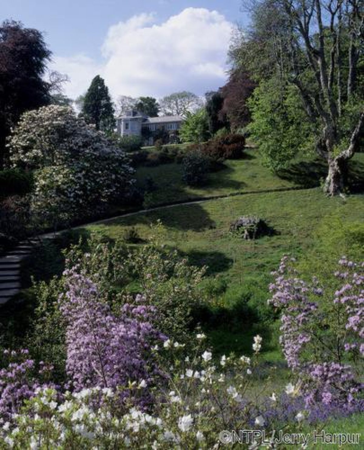
The site comprises a group of three valleys which rise to the north of Durgan which is situated on the north shore of the Helford River. The principal valley ascending north from Durgan and the Helford River contains a small stream which flows south-south-east to join the Helford at Durgan. The head of this valley is marked by Glendurgan House. A further valley opens west from the main north/south valley, while a third valley extends north-east below the main house. There are significant views south from the head of the valley adjacent to the House across the gardens to the Helford River and beyond to woodland near Bosahan.
There are also significant internal vistas within the site from high points to the east and west of the main valley such as Manderson's Hill to the east, which affords views across the maze and the western valley, and from the site of the schoolroom at the head of the western valley. Glendurgan House itself acts as an eyecatcher from lower walks in the main valley.
Entrances and Approaches
Glendurgan is approached from the minor road to the north. A late C20 entrance c 130m west of the junction leading south to Bosveal and Bosloe gives access to a drive which extends c 130m south and south-west to reach an area of late C20 car park, to the west of which are situated the late C20 visitor facilities and entrance to the gardens. To the south of the visitors' entrance an informal gravel walk leads to a pair of timber gates supported on simple granite piers of obelisk form which are flanked by a pair of running lead foxes. The gates lead to a late C20 gravel walk flanked by mid C20 informally planted ornamental shrubs which extends c 50m south to a rondpoint, to the east of which is placed a late C20 semicircular timber bench seat. From the rondpoint the mid C19 Camellia Walk leads 80m west to reach the body of the garden.
The C19 entrance to Glendurgan House is situated c 200m south-west of the late C20 visitors' entrance on the minor road to the north of the site. The entrance comprises an ornamental mid or late C19 timber and cast-iron gate with three cast-iron floral motifs in the upper section above vertical rails and saltire stretchers in the lower section. The gate is supported and flanked by a pair of obelisk-shaped granite piers which are in turn flanked by quadrant stone walls. To east and west of the entrance the walls support a pair of white-painted metal running foxes. The entrance leads to a gravelled drive which sweeps south and south-east through mixed ornamental shrubbery and specimen trees planted on lawns, before turning west to approach the carriage court on the east side of the House. A service drive continues round the north side of the House to reach the service quarters to the north-west, and the stables c 80m west of the House. The C19 stables have been converted in the C20 to domestic use, and are in separate ownership.
Principal Building
Glendurgan House is approximately square on plan and comprises a rectangular block to the east with a further rectangular block to the west; this has a canted bay window to the south with an attic dormer above. The House is constructed in pale-painted stuccoed rubble stone under a hipped slate roof. The entrance facade to the east has a projecting porch comprising a flat-roofed first-floor bay supported on a pair of square-section granite columns. The south or garden facade is lit by marginal-glazed windows, those to the ground floor being full length; the west facade, which also overlooks the gardens, is of similar design. To the north of the main house is a lower, slightly recessed two-storey service wing.
Glendurgan House was built by Alfred Fox c 1837 to replace a thatched cottage which had been destroyed by fire in that year. The cottage had been constructed c 1826. The new house was extended by George Fox c 1890.
Gardens and Pleasure Grounds
Formal gardens are situated to the south, west, and north-west of the House, with further extensive areas of informal gardens and pleasure grounds in the valleys to the south, south-east, and south-west of the House.
To the south of the House a gravelled terrace extends below the building; it is enclosed to the south by a mid C20 low rubble-stone parapet wall, and to the east by a stone wall c 3m high in which a timber door leads east to the carriage court. A pair of medieval recumbent stone lions are placed on the outer side of the terrace wall, while a centrally placed step descends from the terrace to a lawn which slopes down to the south revealing views across the gardens, from which the lawn is separated by a south-facing bank planted with mixed specimen shrubs. The lawn returns below the west facade of the House and is enclosed to the west and south-west by further specimen trees and shrubs.
To the north of the service drive which bounds the lawn to the north, further shrubbery screens a walled garden which is approximately rectangular on plan and enclosed by stone walls c 2.5m high. The north wall is buttressed, while that to the west is lower with a gate at the south-west corner of the garden leading to the stables and kitchen garden.
The walled garden is principally laid to grass with herbaceous borders below the north wall which are separated from the lawn by a narrow gravel path and a box hedge. The lawn is planted with a few scattered standard fruit trees, the remnant of an orchard which in the 1930s included 130 varieties of apple and pear. At the western end of the garden is a formal garden of specimen shrubs surrounding a lawn and a central stone sundial. The foundations of a glasshouse survive at the north-east corner of the garden (1999). The walled garden dates from the mid C19 and was formerly an orchard and kitchen garden; its present ornamental layout dates from the early and mid C20.
A gravel walk descends south-west from the south terrace to reach a gravel walk constructed in 1990 which sweeps west across the head of the valley below the lawns, connecting the C19 network of walks on the east and west sides of the valley to the late C20 visitors' entrance and C19 Camellia Walk to the north-east.
From the eastern end of the Valley Head Walk, a serpentine gravel walk descends east-south-east to pass round the upper, north-east end of the valley to the south-east of the House, to an area known as the Cherry Orchard. This area is planted with specimen trees and shrubs, with two mature Liriodendrons to the south-west of the walk; these were planted c 1830. The Cherry Orchard was originally planted by Alfred Fox with cherry and pear trees in the mid 1820s (guidebook 1998). To the south-west of the Cherry Orchard a further gravel walk leads south-south-west below a steep south-facing slope planted with mature specimen trees and shrubs to reach a flight of informal steps which descends to the east of the remains of an early C19 grotto constructed in white quartz.
Below the steps the walk turns south and south-west to pass between an informal pond to the south-east, and a maze to the north-west. The pond is approximately elliptical on plan, and has a central island planted with a specimen deodar cedar; the margins of the pond are planted with ferns, shrubs, and exotic subjects. The pond was constructed by Alfred Fox in 1833 and was originally stocked with trout (ibid).
The maze is planted on a south-east-facing slope c 100m south of the House and is of complex plan with a series of curvilinear gravel walks separated by hedges of cherry laurel clipped to c 1.5m. Although not symmetrical on plan, the maze has four Chusan palms planted towards each corner, while its central point is marked by a thatched rustic summerhouse; this was reconstructed in the late C20 to the original early C19 design, as part of a programme of restoration of the maze. The maze was constructed and planted in 1833 by Alfred Fox, who based his design on that of a maze formerly in Sydney Gardens, Bath (qv).
To the south of the pond the walk joins another walk which leads south-south-west from the south-east end of the Cherry Orchard, continuing south through the valley to the east of a stream which flows between groups of bamboo, tree ferns, and a collection of plants from New Zealand (guidebook 1992). A late C20 timber bridge crosses the stream c 320m south of the House, giving access to walks on the western side of the valley. Some 430m south of the House the walk on the eastern side of the valley passes through an early C19 Cattle Rush, a stone-walled passage c 5m wide which leads down the west-facing slope from fields above the garden to the stream in the valley; this was used in the C19 for watering cattle.
South of the Cattle Rush the walk passes through an area of mature woodland underplanted with hydrangeas and other specimen shrubs, to reach a painted timber gate which leads from the garden to the hamlet of Durgan. To the north-east of the Cattle Rush a flight of informal steps ascends c 190m north-east to reach Manderson's Hill, a promontory above the main valley which is planted with C19 and early C20 specimen conifers and ornamental trees and shrubs. From a late C20 timber viewing platform at the summit there are views west across the garden and the maze.
At the western end of the Valley Head Walk is a small circular, granite-kerbed pool surrounded by ferns, specimen tree ferns, and other moisture-loving and exotic plants including bananas. Mid C19 watercolours (private collection) show whale bones forming an arch above the spring to the north-west but these do not survive (1999). Stone steps ascend south-west of the pool to reach a gravel walk which leads south-south-east from the pleasure grounds adjacent to the House along the east-facing slope of the valley running south from the House.
Some 130m south-south-west of the House this walk passes immediately to the west of and above the maze, while c 270m south-south-west of the House the walk reaches a junction with a secondary walk which descends the east-facing slope to pass across the stream in the valley on the bamboo bridge to provide access to walks on the opposite side of the valley. The main walk on the west side of the valley continues c 160m south above the lower valley garden to reach a simple painted timber kissing-gate which leads from the garden to the donkey track which descends c 100m south-east to the hamlet of Durgan.
A further gravel walk leads north-west from the steps above the pool south-south-west of the House. Turning sharply south, this walk, known as the School Room Walk, extends at a higher level along the east-facing slope above the valley. Some 80m south-west of the House the walk passes through a group of specimen trees and shrubs all of which have a Biblical association; this feature formed part of Alfred Fox's mid C19 garden scheme. The walk follows a serpentine course for c 160m south-south-west with views east and south-east across the valley; above and to the west of the walk is a simple early C20 granite monument commemorating dogs belonging to the Fox family.
Passing through a grove of specimen trees and shrubs, the walk reaches a path which ascends west to a circular area surfaced with shredded bark and enclosed by low laurel hedges. This area supports the Giant's Stride, a timber pole surmounted by a bearing and six ropes; constructed in 1913, this children's game replaced a croquet lawn constructed c 1880. The terrace on which the Giant's Stride stands is supported by walls constructed in the C20 with small stones or pebbles. Below the Giant's Stride the walk sweeps west to pass along the south-facing slope of Birch's Orchard, a valley running west from the main valley south of the House.
On the slope at the head of the valley the site of the mid C19 schoolroom survives as a level platform surrounded by ornamental trees and shrubs. The schoolroom was constructed c 1840 by Sarah Fox and was used by her to teach her own children and those from the parish of Mawnan (guidebook 1992). The schoolroom was replaced by a more substantial structure in Durgan in 1876.
A flight of steps with slate risers descends to a path leading east down the valley. This path follows a stream which has been dammed to form several pools, and which is planted with water-loving plants, tree ferns, and a collection of hydrangeas. This path joins the lower walk on the west side of the main valley c 270m south-south-west of the House. Birch's Orchard widens to the east and is laid out with specimen tree ferns and other ornamental trees and shrubs. In the C19 Birch's Orchard was planted with fruit trees; it was incorporated into the garden and planted with ornamental subjects in the 1930s.
Park
The site includes two areas of paddock. The larger area, situated c 130m east of the House, comprises a south-east-facing slope which today (1999) remains pasture. The paddock is enclosed to the north, east, and south-west by mixed boundary plantations, while to the west it adjoins trees and shrubbery in the garden, from which it is separated by metal and timber fences. To the north-west the paddock adjoins the late C20 visitors' car park which is enclosed by timber fences.
A second, smaller paddock, known as the Pony Field, is situated c 190m south-west of the House. This paddock adjoins the head of the valley known as Birch's Orchard to the south, and the orchard to the north. A path passing through the paddock from north to south formerly provided access to the mid C19 schoolroom at the head of Birch's Orchard.
Kitchen Garden
Situated c 100m south-west of the House, the kitchen garden comprises an approximately square area enclosed by laurel hedges and fences. It remains in partial cultivation as a nursery (1999), with a range of C20 frames and glasshouses parallel to its northern boundary, and fruit trees including a medlar and fig. To the south-west of the kitchen garden is an orchard with standard fruit trees planted in grass. The orchard and kitchen garden are shown on the 1878 OS map, and had assumed their present configuration by 1907 (OS).
References
Lake's Parochial History of Cornwall iii, (1870), p 303
E Thurston, British and Foreign Trees and Shrubs in Cornwall (1930), pp 54-55
P Synge, The Gardens of Britain I, (1977), pp 99-101
G S Thomas, Gardens of the National Trust (1979), pp 138-139
B Elliott, Victorian Gardens (1986), pp 45-46
Country Life, no 10 (5 March 1992), pp 54-57
Glendurgan Garden, guidebook, (National Trust 1992)
Glendurgan Garden, guidebook, (National Trust 1998)
D E Pett, The Parks and Gardens of Cornwall (1998), pp 114-115
Maps
OS 25" to 1 mile: 1st edition published 1878
2nd edition published 1907
Illustrations
Watercolour views of Glendurgan by members of the Fox family, mid C19 (private collection)
Description written: October 2000
Amended: January 2001; March 2001
Edited: October 2001
- Visitor Access, Directions & Contacts
Telephone
0844 800 1895Website
http://www.nationaltrust.org.ukAccess contact details
The site is open only between February and November. Please see: http://www.nationaltrust.org.uk/place-pages/144/pages/opening-times-calendar
Directions
The garden lies 4 miles south-west of Falmouth. Further directions are available from the National Trust.
Owners
The National Trust
Heelis, Kemble Drive, Swindon, SN2 2NA
- History
The following is from the Register of Parks and Gardens of Special Historic Interest. For the most up-to-date Register entry, please visit the The National Heritage List for England (NHLE):
www.historicengland.org.uk/listing/the-list
HISTORIC DEVELOPMENT
The Fox family, noted Quakers, had been established in Falmouth since 1762 where their interests included a ship agency. Robert Were Fox I inherited part of Penjerrick, a small estate outside Falmouth in the late 18th century, and in 1839 Robert Were Fox II purchased the freehold interest in the property; other members of the family also acquired small estates in the vicinity of Falmouth in the early 19th century. During the 1820s Alfred Fox (b 1794), third son of Robert Were Fox I, is believed to have rented cellars and orchards in the coastal hamlet of Durgan, and subsequently bought land in the valleys rising to the north of the village. Here, towards the head of the main valley, a thatched cottage had been built by 1826, and Alfred Fox and his wife, Sarah, began to clear the valleys and lay out gardens. Barclay Fox, Robert's nephew, recorded visiting Glendurgan and assisting in tree-felling in 1833 (Journal, quoted in Pett 1998), and the same year the maze of cherry laurel was planted (guidebook 1998). The layout of the principal walks was established by Alfred Fox, while a pond stocked with trout was constructed and cherry and pear orchards planted; rare plants for the gardens were acquired through the family's shipping interests. A schoolroom for the children of Durgan and the family was established by Sarah Fox in 1829 using the former pound house in the grounds. In 1837 the cottage was destroyed by fire, and was subsequently replaced by a more substantial house to accommodate Alfred Fox's growing family which eventually numbered twelve. After Alfred Fox's death his widow continued to live at Glendurgan until her own death in 1890, when the property passed to their fifth son, George Henry, a keen botanist. Under George Fox the plant collections were maintained and expanded, with a particular emphasis on conifers and tender rhododendrons (Pett 1998). George Fox died in 1931 and was succeeded by his eldest son, Cuthbert Lloyd Fox, who with his wife, Moyra, continued to develop the garden. In 1962, to mark the bicentenary of the establishment of the family business in Falmouth, Cuthbert and Moyra Fox and their son, Philip, presented Glendurgan to the National Trust. Today (2000) the site remains the property of the National Trust, which in the late 20th century has undertaken a programme of restoration.
Glendurgan is one of a group of gardens in and around Falmouth which were established and developed in the 19th century by members of the Fox family. These include Penjerrick and Trebah which adjoins Glendurgan to the west; these sites share characteristics of planting and design.
- Associated People
- Features & Designations
Designations
The National Heritage List for England: Register of Parks and Gardens
- Reference: GD1640
- Grade: II
Features
- House (featured building)
- Description: In 1837 the cottage which had been the family home was destroyed by fire, and was subsequently replaced by a more substantial house.
- Earliest Date:
- Stream
- Description: The principal valley ascending north from Durgan and the Helford River contains a small stream which flows south-south-east to join the Helford at Durgan.
- Maze
- Description: Laurel maze
- Trees
- Gardens
- Planting
- Key Information
Type
Garden
Purpose
Ornamental
Principal Building
Domestic / Residential
Survival
Extant
Hectares
14
Open to the public
Yes
Civil Parish
Mawnan
- References
References
- {English Heritage Register of Parks and Gardens of Special Historic Interest} (Swindon: English Heritage 2008) [on CD-ROM] Historic England Register of Parks and Gardens of Special Historic Interest
- Thomas, G S {Gardens of the National Trust} (1979) pp 138-139 Gardens of the National Trust (1979)
- Pett, D E {The Parks and Gardens of Cornwall} (1998) pp 114-115 The Parks and Gardens of Cornwall