Introduction
Thornton Manor has a landscape park and gardens of around 49 hectares. Features include extensive woodland, a lake with a boathouse and a walled garden.
Terrain
The site is set in gently rolling agricultural land.www.historicengland.org.uk/listing/the-list
Park and gardens designed by Thomas Hayton Mawson in collaboration with the industrialist and philanthropist William Hesketh Lever, later first Viscount Leverhulme.
DESCRIPTIONLOCATION, AREA, BOUNDARIES, LANDFORM, SETTING
Thornton Manor is set in gently rolling agricultural land c 1km north-west of Thornton Hough. The c 49ha site is bounded on the east side by Manor Road where the boundary is formed by a red sandstone wall. The north-eastern boundary is formed by a footpath which runs west from Manor Road before curving southwards where it cuts through the site. A brick wall runs for c 150m west from Manor Road where there is a boundary between the site and the gardens of Copley House. The rest of the boundary is delineated by fencing along the edges of wooded areas.
ENTRANCES AND APPROACHES
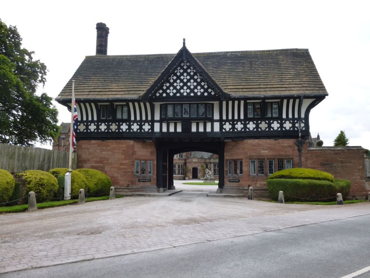
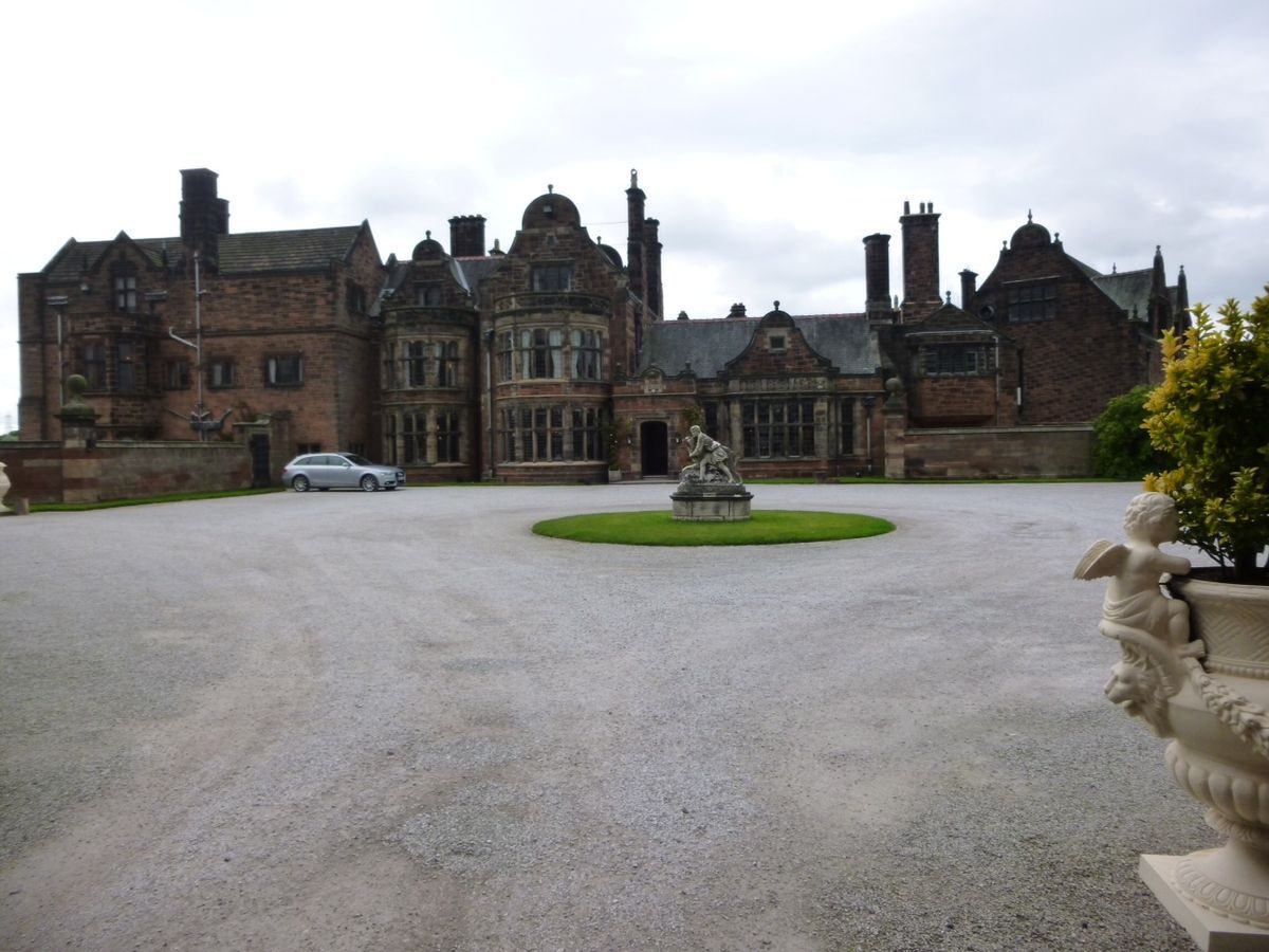
The principal entrance is on Manor Road where a gatehouse designed by J Lomax Simpson (listed grade II) leads to a walled forecourt in front of the house. There is a secondary entrance with a lodge, also on Manor Road, at the south-east corner of the site. North of the main entrance are a number of subsidiary entrances leading to the estate yard and working areas which are marked by stone gate piers. An entrance was formerly situated to the north where there is a lodge on Brimstage Road and a drive which leads into the woodland at the northernmost boundary of the park.
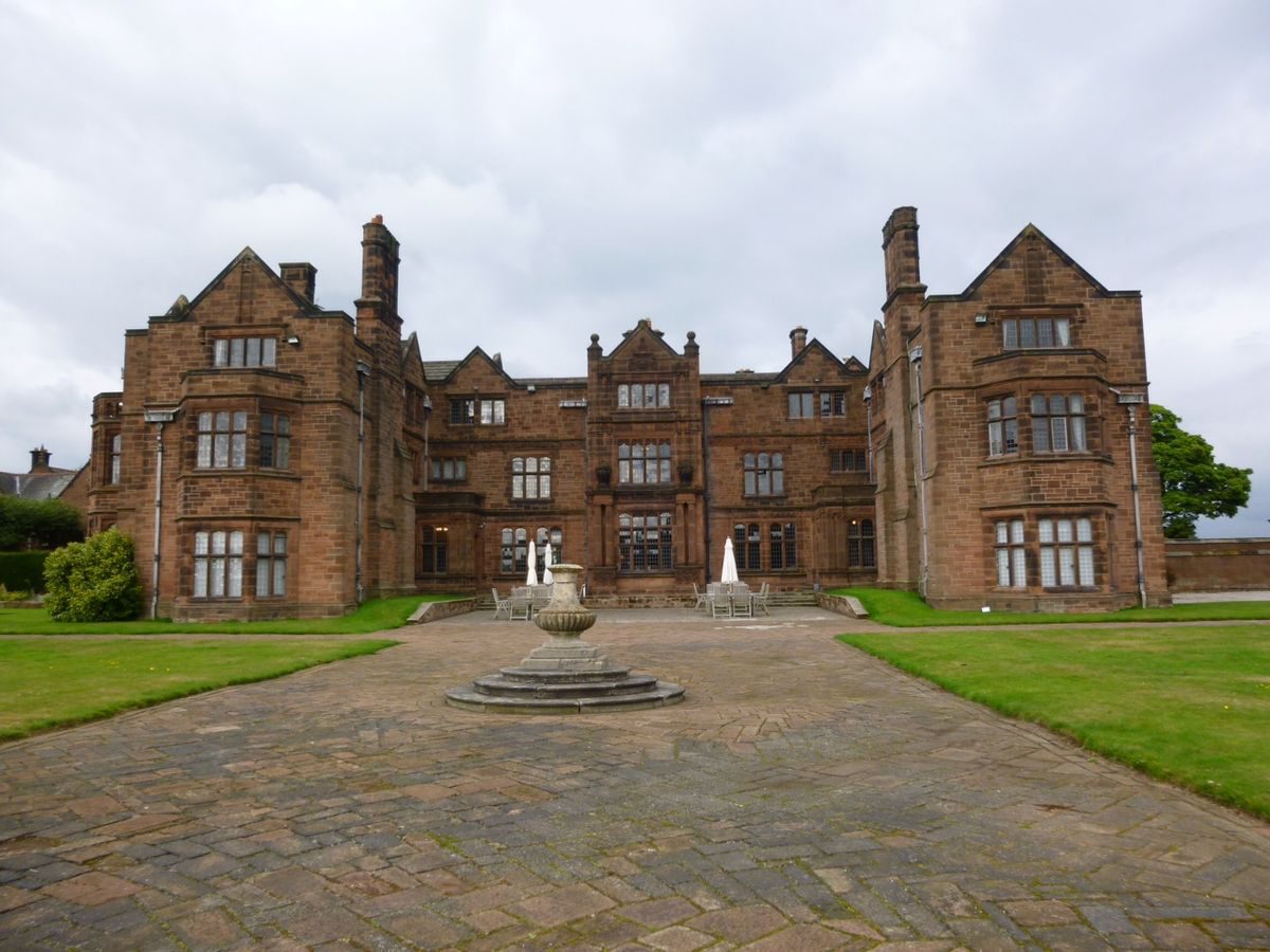
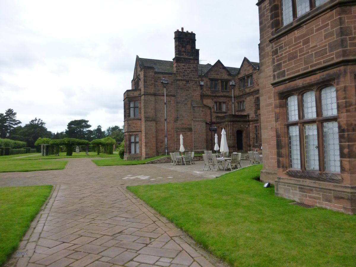
PRINCIPAL BUILDING
Thornton Manor (listed grade II) originated as an early Victorian house. A series of alterations and additions followed after 1891 and these were executed by Jonathan Simpson, Douglas & Fordham, J J Talbot, and finally J Lomax Simpson who designed the east, garden front.
GARDENS AND PLEASURE GROUNDS
The south front of the house faces a terrace divided into geometrical beds by a system of wide paved walks. The terrace is stepped back on each side of the area immediately in front of the house and on each side are axial walks planted with lime trees. North of the eastern lime walk there is a rectangular lawn with an arcaded stone loggia at its eastern edge. North of the western lime walk is a columned pergola known as The Forum, which consists of a rectangle formed by paired Tuscan columns of concrete enclosing a lawn. To the north of this, on the north-west side of the house, an intimate area is formed between the house and kitchen garden. This area is screened from the terrace by yew hedges and has another walk lined with lime trees giving a view from the dining room window to the wall of the kitchen garden. The remains of a conservatory shown by Mawson on a plan published in The Art and Craft of Garden Making in 1912 are visible on the north side of this walk. To the north of this, forming the south-west corner of the kitchen garden c 30m from the house, is a stone loggia with a balustraded roof walk giving views over the kitchen garden, the gardens and the park. This was designed by Lomax Simpson in 1912 and is not shown on Mawson's plan.
A path leads west from the terrace past The Forum and in front of the kitchen garden loggia. In front of the loggia is a rectangular lawn and south of this a tennis court. The path continues westwards through an area with raised geometric beds, to a sunken circular rose garden c 150m west of the house. A belt of trees on the southern edge of this area screens it from the park. A path runs north from the rose garden to a door in the splayed northern corner of the kitchen garden. Another path leads west for a distance of c 150m to a footbridge formed from a stone structure called The Lookout designed by Douglas & Fordham and moved here from its original position (Pevsner 1971). The footbridge leads over a public footpath to a path into the woods beyond. The main path continues south from this point along the edge of the park, following the line of the public footpath which is screened by planting in front of a fence. Another footbridge, c 180m south of the first, leads over the public footpath to the woods and a lake to the west. The path returns eastwards along the edge of the parkland to an area known as The Dell which is situated c 350m south-west of the house. This is a secluded area screened by trees where there are two ornamental pools with rebuilt footbridges. Some 40m south of these is another pond. The path continues back to the house leading through a belt of woodland on the southern boundary of the site. It emerges at the south-east end of the formal gardens having taken a route around the parkland.
PARK
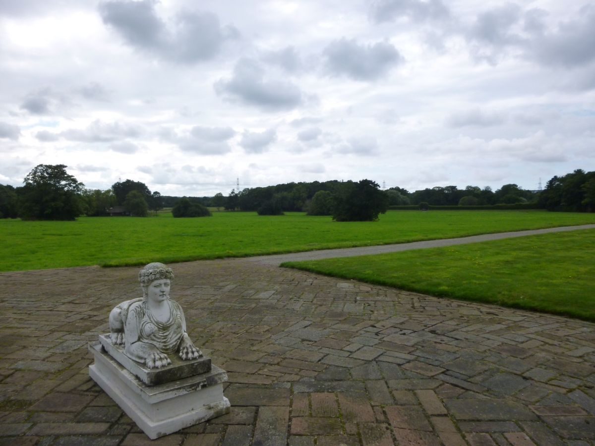
An area of informal parkland to the south of the house is overlooked by the terrace and is characterised by loose planting of trees as individuals or in clumps. It is said to have been laid out as a golf course by the first Viscount Leverhulme (Kenyon pers comm). A cricket pitch was situated to the south-west of the house and a cricket pavilion, probably of early C20 date, is situated on the southern edge of the parkland c 300m south-west of the house. A later C20 stable is situated in the northern part of the park c 200m west of the house. The remainder of the site to the west is on the other side of the public footpath which runs roughly from north to south across the site; it consists of a wooded area with a large lake which is situated in the north-west corner of the site. The lake has three large islands and a number of smaller ones arranged so that the full extent of the water cannot be appreciated from any one viewpoint. Aligned with the house and connected to the lake is a canal which runs westwards almost to the western edge of the site. This is illustrated in Mawson's The Art and Craft of Garden Making. To the south of the canal is Manor Wood which is shown as an area of woodland on the 1847 Tithe map. Thick tree cover surrounds the lake and canal. Paths lead through the woodland but various structures which once stood there, including boathouses, have been destroyed.
KITCHEN GARDEN
A large walled kitchen garden is situated c 30m north-west of the house. It is square in plan with splayed corners. The walls are of brick with the upper stage in red sandstone on the western wall which abuts with the pleasure grounds. The interior was laid out with formal paths dividing the garden into square and triangular areas, as shown on an undated late C20 aerial photograph and illustrated by Mawson's plan, photographs and written description in The Art and Craft of Garden Making. It was ornamented with various urns and a fountain as well as arched pergolas. What survived of these arrangements was obliterated after the garden was leased out c 1980 for use as commercial gardens. Many of the moveable items, including the cast-iron pergola hoops shown in Mawson's photographs, have been reused in other parts of the garden.
To the east of the kitchen garden is an area of glasshouses, and to the north an estate yard with buildings of mid and later C20 date.
REFERENCES
C Holme, Gardens of England in Northern Counties (1911), plates 126-8
T H Mawson, The Art and Craft of Garden Making (1912), pp 49, 193, 239, 245, 247
N Pevsner, The Buildings of England: Cheshire (1971), pp 359-60
Thomas H Mawson, (University of Lancaster 1976), p 18
Country Life, 178 (5 September 1985), pp 602-5
Maps
Tithe map for Thornton Hough, 1847 (Cheshire Record Office)
OS 6" to 1 mile: Cheshire sheet XXII, 1st edition surveyed 1871-2, published 1882; Cheshire sheet XXII NE, surveyed 1871-2, revised 1935
Description written: July 1997
Edited: March 1999
- Visitor Access, Directions & Contacts
Telephone
0151 353 1155Website
https://thorntonmanor.co.ukAccess contact details
The property is normally only available for private functions.
Directions
12 miles north of Liverpool, off the M53 junction 4.
- History
The following is from the Register of Parks and Gardens of Special Historic Interest. For the most up-to-date Register entry, please visit the The National Heritage List for England (NHLE):
www.historicengland.org.uk/listing/the-list
HISTORIC DEVELOPMENT
W H Lever first moved to Thornton Manor in 1888, renting the modest Victorian house so that he could be close to Port Sunlight. He bought it in 1891 and began a campaign of works on both the house and gardens. Thomas Mawson (1861-1933) was invited to advise on the garden in 1905 and work on house and grounds continued until the First World War. The gardens were the first of a series of three major private gardens produced by Mawson in collaboration with the Lord Leverhulme, the other two being The Hill, Hampstead, London and Roynton Cottage, Rivington Gardens, Lancashire (there are descriptions of both these sites elsewhere in the Register). Thornton Manor remains in use as a private residence (1997).
- Associated People
- Features & Designations
Designations
The National Heritage List for England: Register of Parks and Gardens
- Reference: GD2000
- Grade: II*
Features
- Lake
- Lawn
- Avenue
- Boat House
- Boundary Wall
- Description: Part of the boundary is formed by a red sandstone wall.
- House (featured building)
- Earliest Date:
- Latest Date:
- Key Information
Type
Park
Purpose
Ornamental
Principal Building
Domestic / Residential
Survival
Extant
Hectares
49
Open to the public
Yes
- References
References
- Mawson, T. H., {The Art and Craft of Garden Making} ([n.p]: [n.pub], 1912), pp. 49, 193, 239, 245, 247 The Art and Craft of Garden Making
- {English Heritage Register of Parks and Gardens of Special Historic Interest}, (Swindon: English Heritage, 2008) [on CD-ROM] Historic England Register of Parks and Gardens of Special Historic Interest
- Pevsner, N. and E. Hubbard, {The Buildings of England: Cheshire} (Harmondsworth: Penguin, 1971), pp. 359-60 The Buildings of England: Cheshire
- Holme, C. (ed), {The Gardens of England in the Northern Counties} (London: The Studio, 1911), plates 126-8 The Gardens of England in the Northern Counties
- Luczak, Maria {Thornton Manor Landscape Management Plan} (2008) Thornton Manor Landscape Management Plan