Introduction
The site at Port Sunlight comprises three landscaped areas within a garden village laid out in the late-19th and early-20th centuries, to house workers in the soap factory inaugurated in 1888. There is the Dell created in a former tidal channel, and two formal intersecting areas known as The Causeway and The Diamond. All these public open spaces are surrounded by housing with open-plan gardens.
Terrain
Level.www.historicengland.org.uk/listing/the-list
The principal public open spaces of The Dell, The Diamond, and The Causeway within a garden village laid out in the late C19 and early C20 largely to the overall plans of William Hesketh Lever, with formal open spaces based on a 1910 competition design by Ernest Prestwich.
DESCRIPTION
LOCATION, AREA, BOUNDARIES, LANDFORM, SETTING
Port Sunlight Village, an area of c 53ha, lies c 5km south-south-east of Birkenhead. The c 1ha area of The Dell (part of the area here registered) occupies a partly in-filled former tidal channel running from north-east to south-west in the south of the village. The irregular site is bounded to the south-east and north-east by Park Road and to the north-north-west adjoins the Lyceum and Bath Road. These boundaries are generally unmarked, with the south-east boundary with Park Road partly marked by a low hedge.
The c 1.9ha area of The Diamond and The Causeway (part of the area here registered) occupies level ground in the west of the village. The Diamond is bounded to the east by King George's Drive, to the north by Windy Bank, and to the west by Queen Mary's Drive. The two formal, axial landscaped areas of The Diamond intersect with the formal layout of The Causeway. The latter is bounded to the north and south by two roads named The Causeway, to the east by Church Drive, and to the west by Greendale Road. Boundaries are generally unmarked with a stone balustrade to the raised rose garden at the southern end of The Diamond.
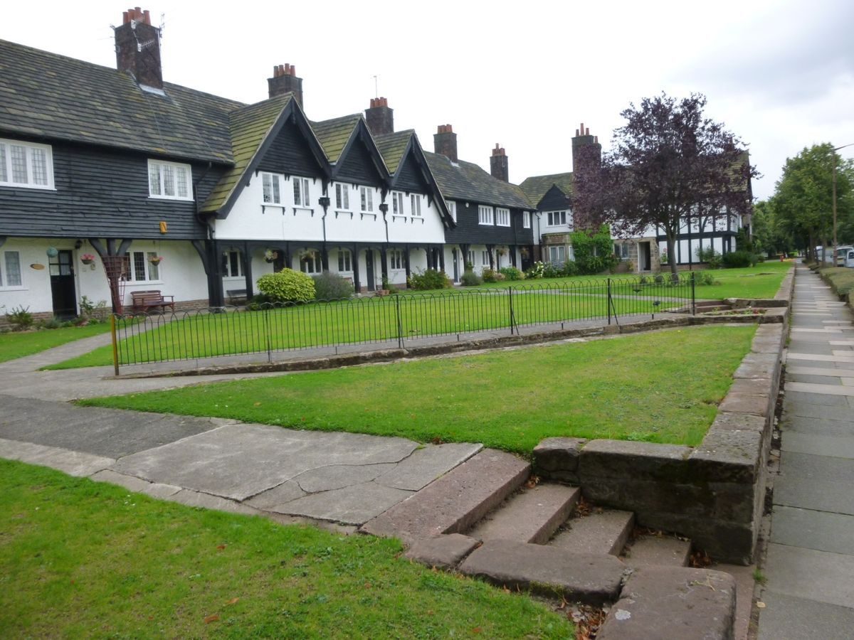
Both The Dell and the intersecting Diamond and Causeway sites are generally surrounded by two-storey housing set within individual but open-plan gardens, forming part of the garden village. Port Sunlight Village, with the factory complex immediately to the south-east, encompasses a number of other landscaped open spaces, including three bowling greens, but these are generally laid to grass with trees (all of these other areas outside the areas here registered).
ENTRANCES AND APPROACHES
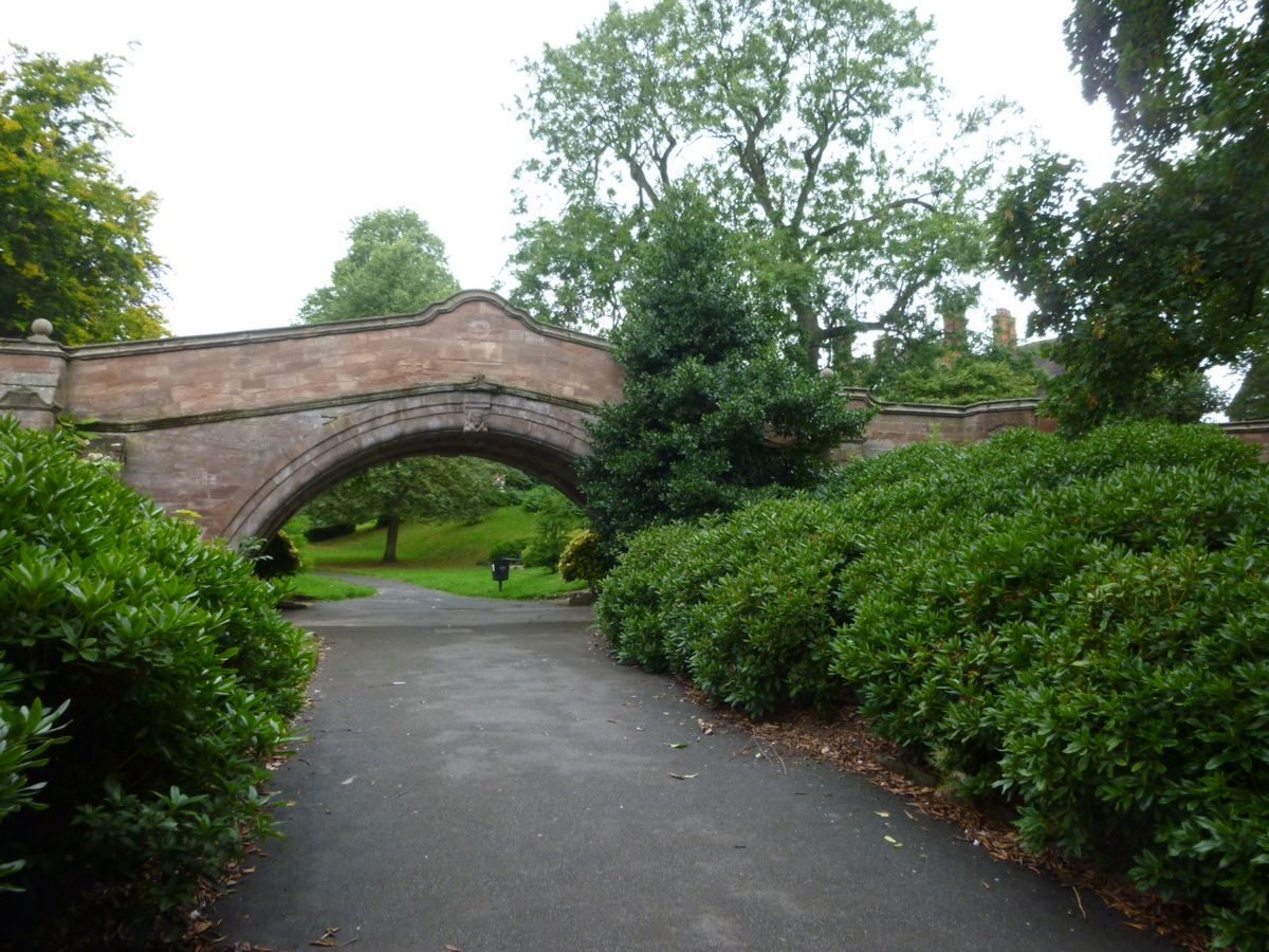
Access to the lower level of The Dell is via winding stone steps leading down from the adjoining roads with two pairs of steps sited on either side of a sandstone bridge (listed grade II) which leads across the centre of The Dell and links the two sections of Bridge Street to the north-west and south-east. The bridge dates from 1894 and was designed by Douglas and Fordham.
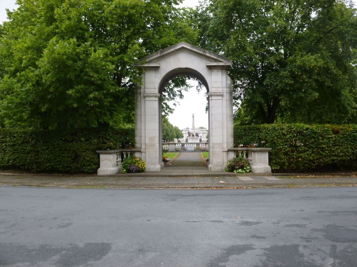
The northern approach to The Diamond is from Windy Bank, which widens to form an informal forecourt between the Lady Lever Art Gallery and the north end of The Diamond. From the south a short road leading north-west from Bolton Road forms a short axial route terminating at a stone archway flanked by stone balustrades (the whole listed grade II with the rose garden) leading into the rose garden at the southern end of The Diamond. Access into The Causeway is from the axial roads of Church Drive to the east and Greendale Road to the west.
PRINCIPAL BUILDINGS
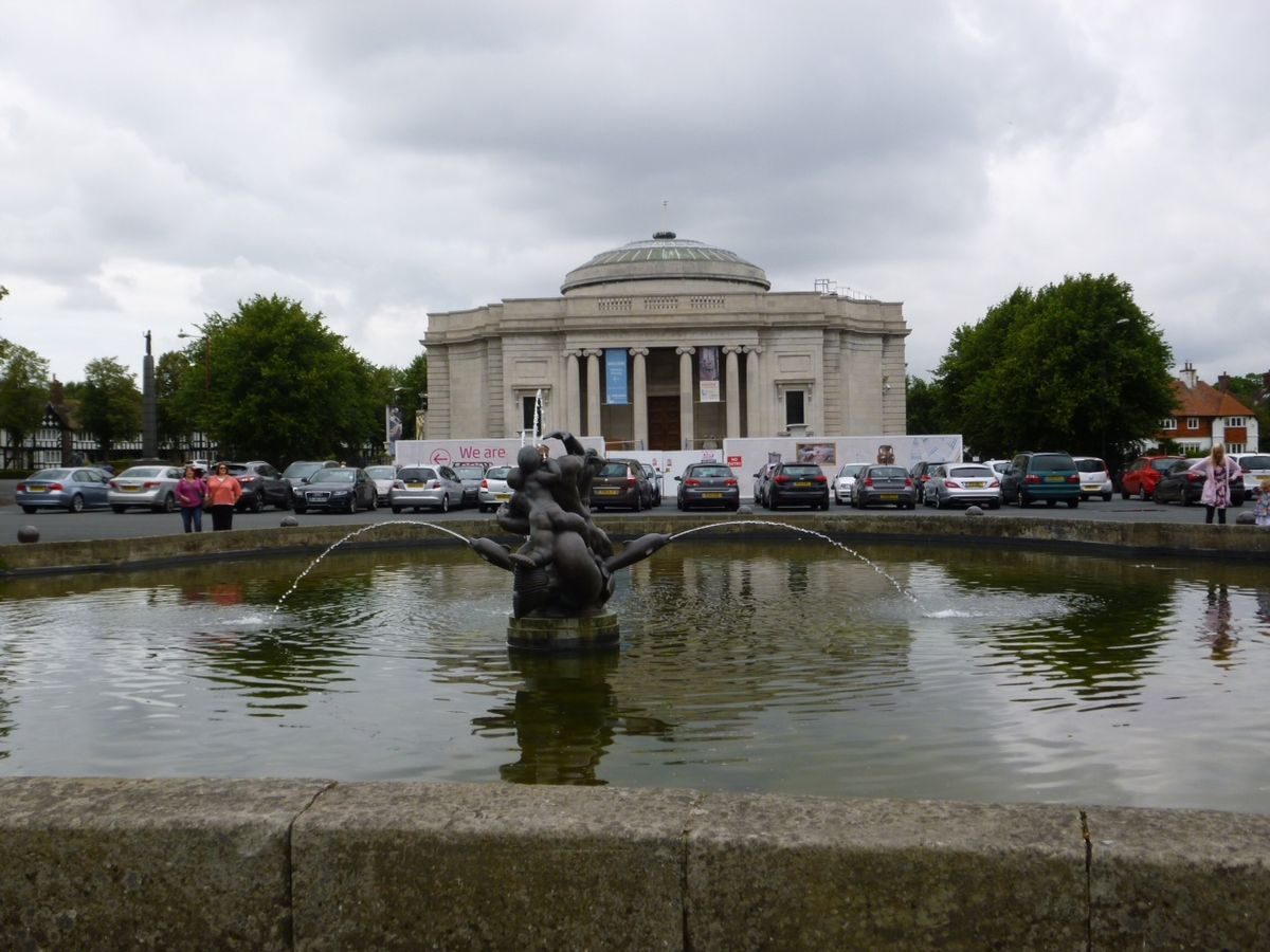
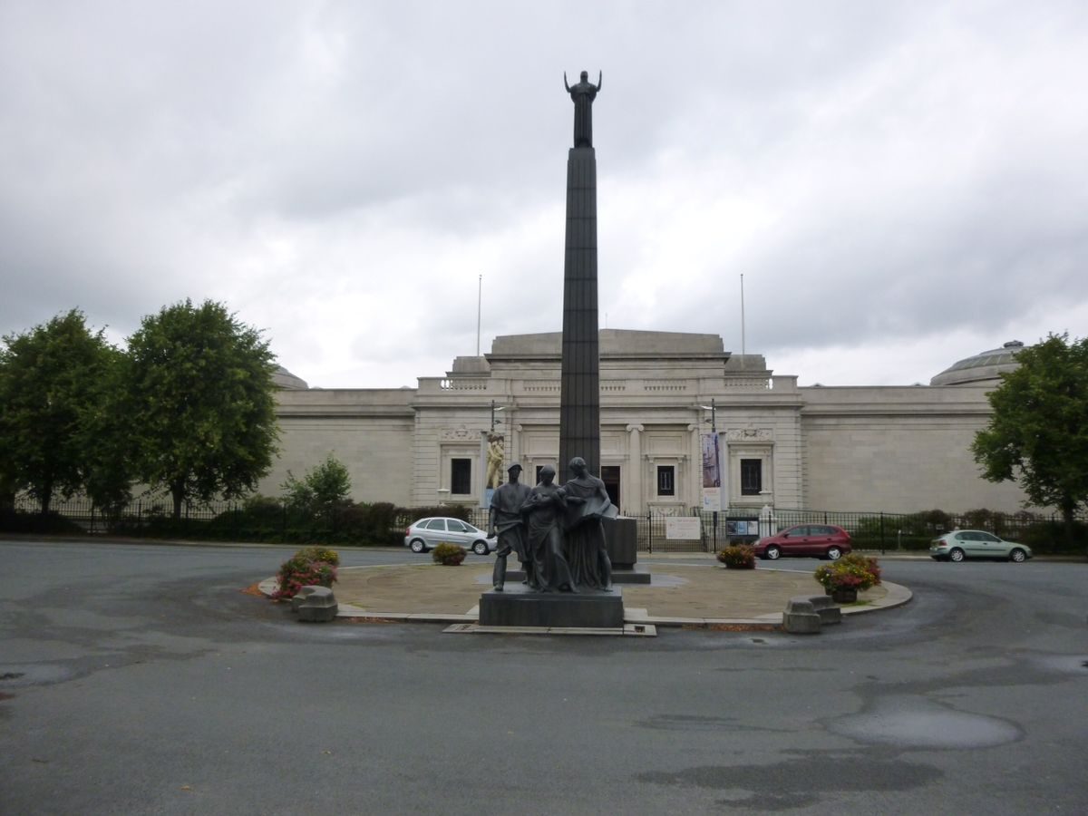
The Lady Lever Art Gallery (listed grade II), bounded by railings, is situated at the northern end, and on the main axis of the formal open space of The Diamond to which it provides a focal point and closing feature. It was built in 1913-22 and designed in a restrained Beaux Arts classical style by William and Segar Owen with Portland stone cladding and four entrances, one to each side, each with recessed porticoes of fluted Ionic columns. The gallery was conceived and built by Lever as a memorial to his wife who died in 1913 and is an addition to the 1910 Prestwich scheme.
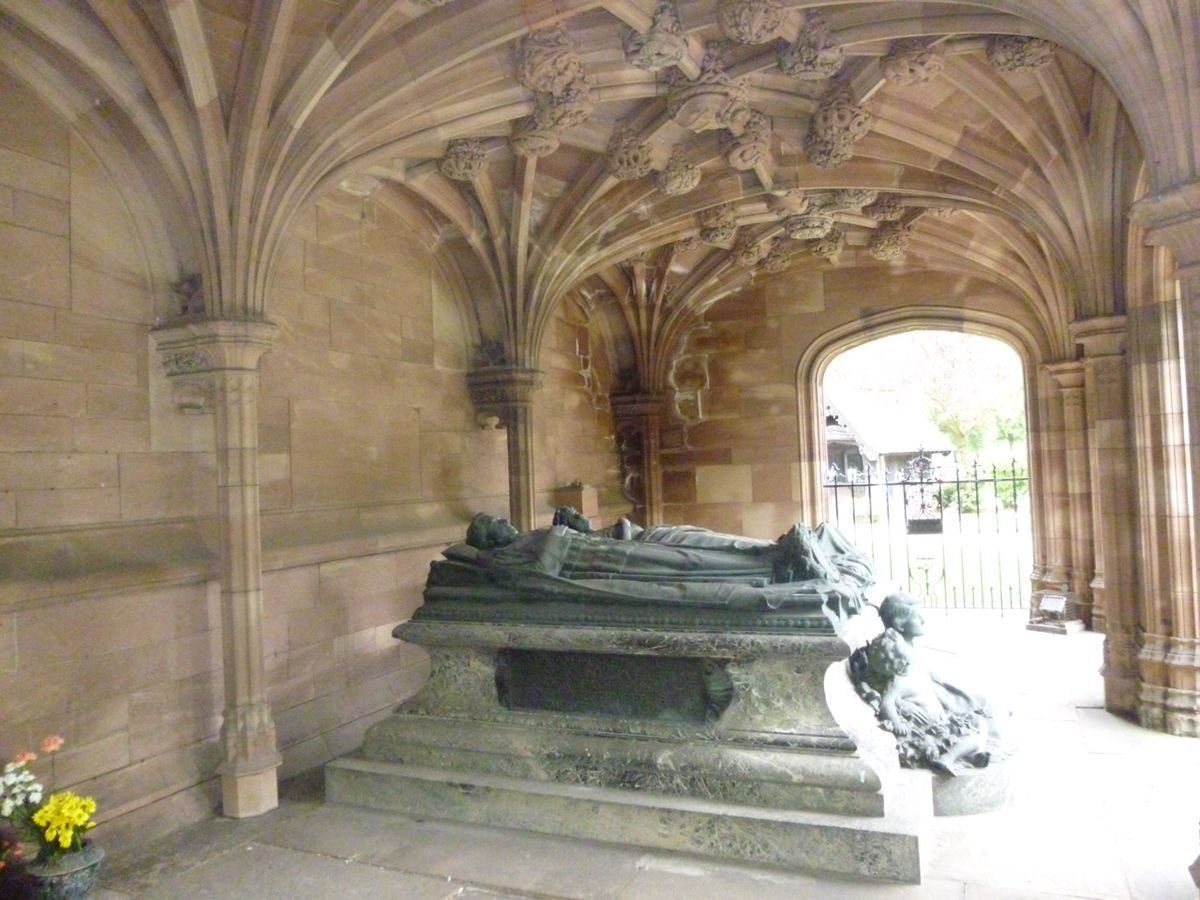
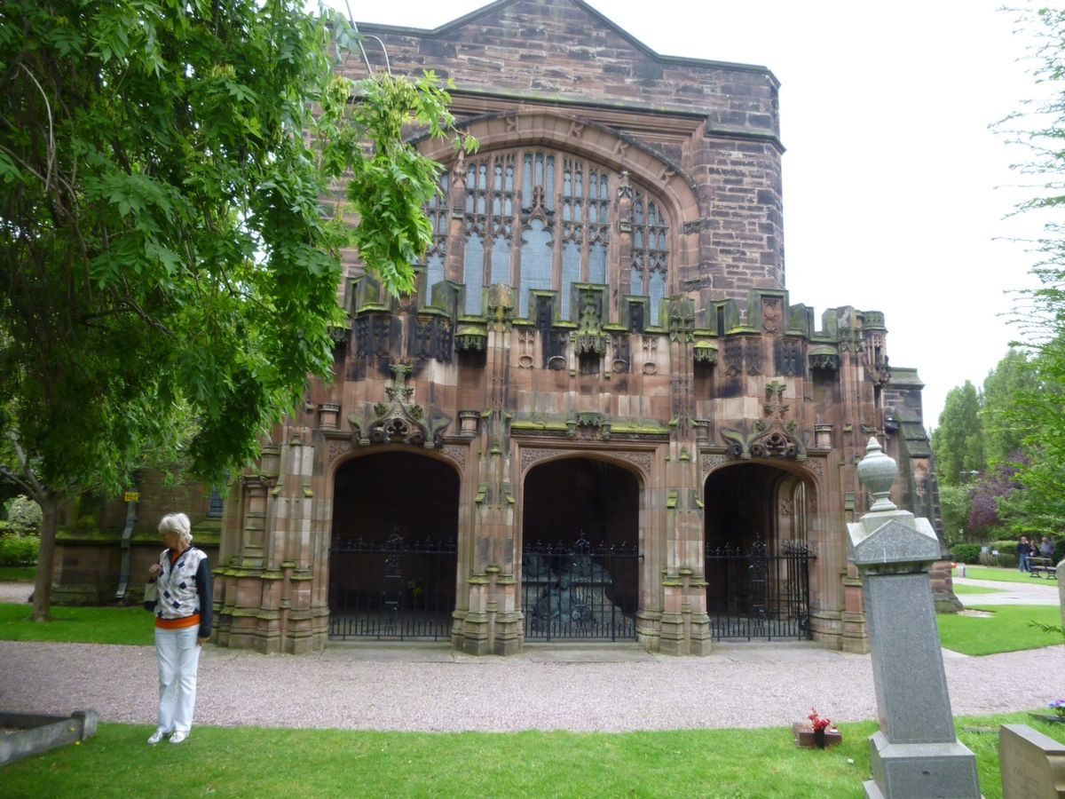
Christ Church (listed grade II*) is situated on Church Drive within a semicircular burial ground, enclosed by railings, which extends eastwards to King Edward's Drive. The red sandstone church in late Perpendicular Gothic style was built in 1902-4 to a design by William and Segar Owen and provides a focal point and closing feature at the eastern end of the cross-axial Causeway. The burial ground is centred on the cross-axis, as proposed in the 1910 Prestwich scheme, with the church sited askew at the centre, this siting apparently determined by alignment to a tidal channel (Plan, 1902). Formal landscaping proposed by Prestwich within the burial ground does not appear to have been implemented (OS 1936).
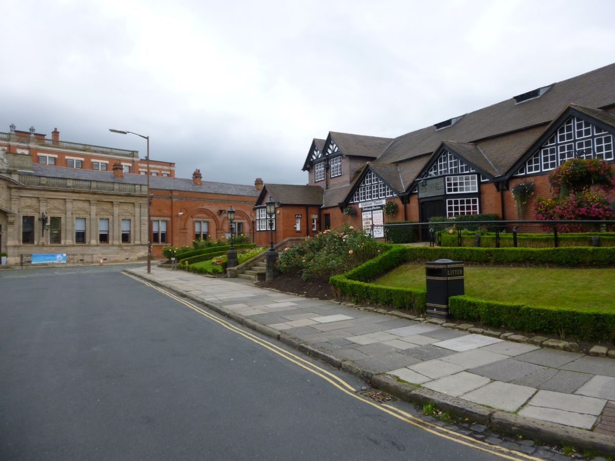
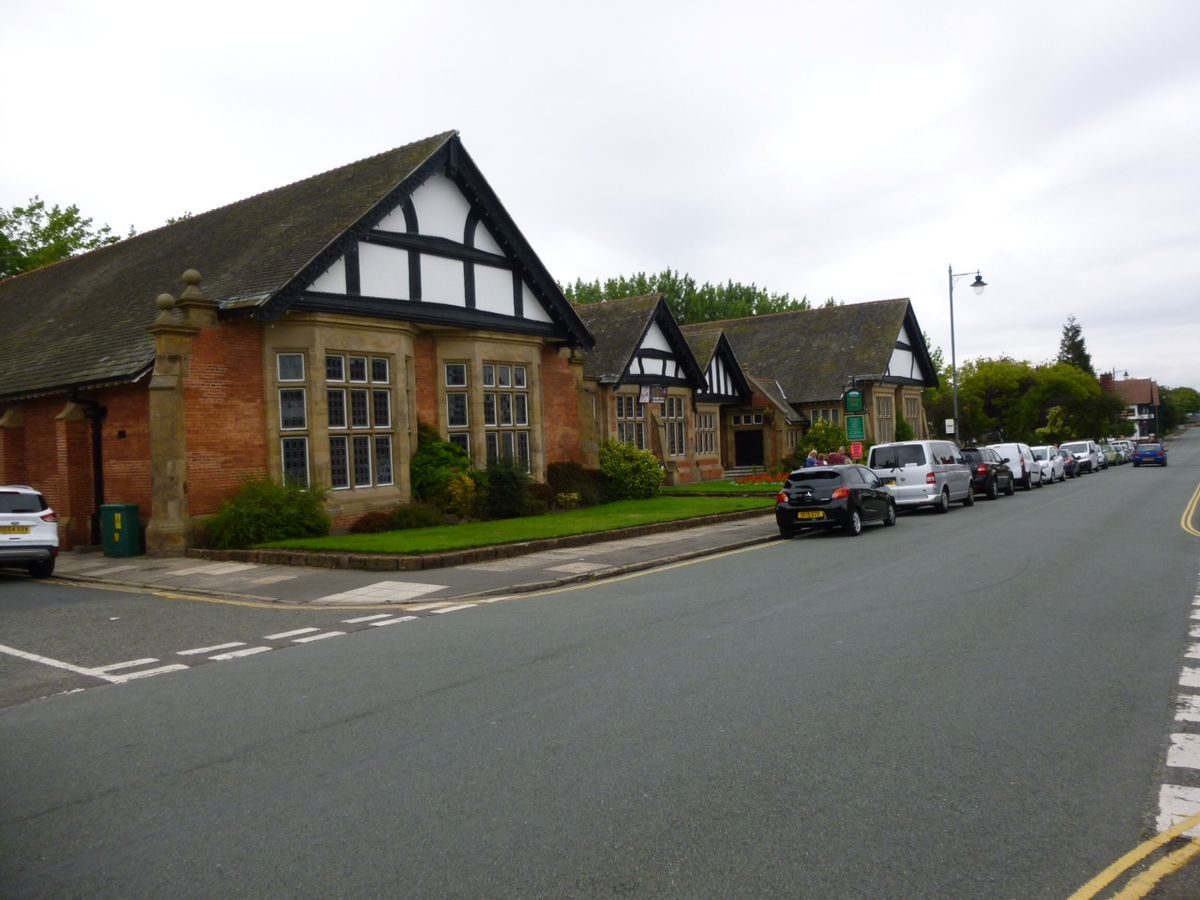
The Lyceum (listed grade II) is situated on Bridge Street at the centre, and to the north-west of, The Dell in the south-west of the village from where the tall gables and octagonal clock tower with a short spire form a dominant feature. The brick building with stone detailing dates from 1894-6 and was designed by Douglas and Fordham.
GARDENS AND PLEASURE GROUNDS
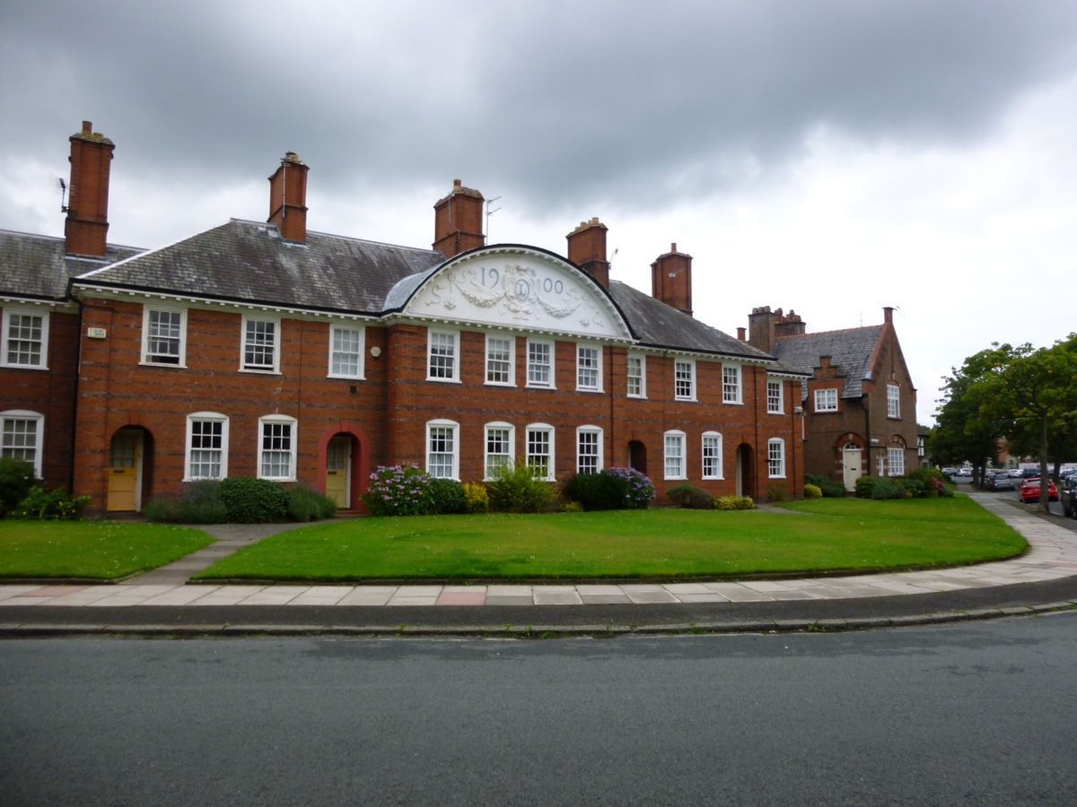
Port Sunlight Village is characterised by wide roads flanked by broad pavements and open-plan lawned front gardens to blocks of generally two-storey houses, interspersed with low-rise public buildings and open spaces. Some short lengths of late C19/early C20 railings remain to front gardens. The village is enlivened by the wide variety of building design, generally in vernacular style, and detailing ranging from restrained brickwork to exuberant half timbering and pargetting. Pavements, with stone and concrete paving, generally have an outer margin strip with tree planting. The margin strip with stone kerb is generally asphalted, but is planted with low hedging on sections of Windy Bank and roads adjoining The Diamond. A number of road junctions are marked by late C19/early C20 detailing with bands of stone setts and paving.
In the south-west area of the village the main open space is The Dell, an informal sunken public park with a winding central path leading from south-west to north-east for c 290m. At the centre The Dell is crossed by a sandstone pedestrian bridge from where there are views down into the landscaped areas to the north-east and south-west. The bridge links and is axial with two sections of Bridge Street to the north-west and south-east and is aligned on and gives direct access to the former main factory entrance to the south-east. Immediately to the north of the bridge The Dell is overlooked by the Lyceum. Roads bounding The Dell are situated at the head of the grassed slopes of the sunken area with views down grassed slopes between shrub beds and mature trees. To the south-west of the bridge the slopes are partially lined with rockwork and to the north of the bridge with low stone retaining walls which at the north-east end enclose a wider level area. The Dell was formed from a drained tidal channel as the principal open space of the earliest part of the village completed in 1889?97. The plan of 1902 and 1936 OS map show The Dell laid out with circuit paths and the northern area occupied by a large Auditorium building. Some evidence of the circuit path remains (2002) in the form of level grassed areas on either side of the central path. The Auditorium, built in 1902?6, was demolished in 1937. It is understood that the rockwork was constructed during the Second World War by Italian prisoners of war (Kelly 2001).
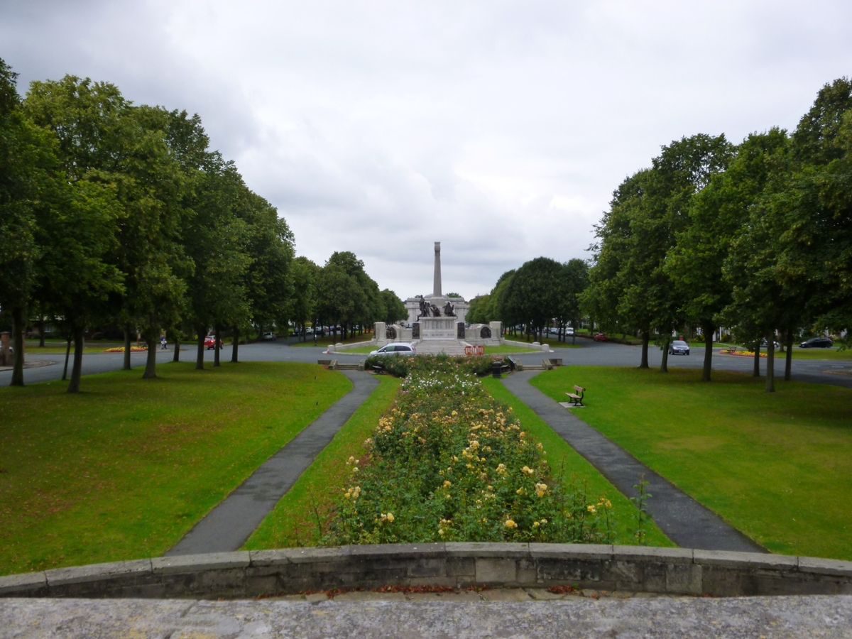
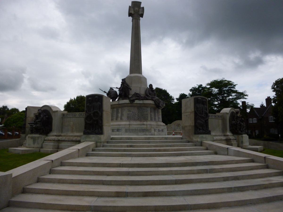
The Diamond, c 40m wide and c 350m long, forms a formal, approximately north/south axis parallel to Greendale Road on the western boundary of the village. Some 120m from its southern end the cross-axial Causeway is laid out symmetrically to east and west. The junction of The Diamond and The Causeway is marked by a war memorial (listed grade II), designed by Sir W Goscombe John and erected 1916?21. The large circular granite structure surmounted by bronze sculptures below a Celtic cross forms a central focal point in the formal design. The Diamond is bounded by King George's Drive to the east and Queen Mary's Drive to the west, generally with housing, all dating from 1911 to 1913 and by J Lomax-Simpson, facing on both sides. The ground in both north and south sections of The Diamond falls slightly towards a central level area. Each of these areas is laid out with a central stone-edged linear bed planted with roses flanked by narrow strips of lawn and paved paths beyond which gently sloping lawns are lined with a double row of trees at the outer edges. At the centre of the northern section this layout is replaced by a paved area, with stone steps leading down from the flanking roads, laid out with a formal arrangement of small island beds. This is the site of a former bandstand demolished in the 1930s. Early C20 illustrations (Hubbard and Shippobottom 1988) show the two areas of The Diamond enclosed by railings, outside two outer lines of trees, and with the whole area laid to grass. At the northern end The Diamond terminates, c 35m south of the Lady Lever Art Gallery, at a bronze fountain set within a low stone-walled pond (pond and fountain listed grade II) with an ornate curved and swept plan. The pond dates from c 1913 and the fountain, by Sir Charles Wheeler, from 1946. The southern end of The Diamond terminates in a raised rose garden with stone terrace and walls with an ornamental arch to the south and lion-mask fountain above a shallow semicircular basin to the north (the whole listed grade II). From the raised garden there are long views north along The Diamond to the war memorial and the art gallery beyond. This feature dates from c 1936 and was designed by J Lomax-Simpson. Both this and the northern pond are additions to the 1910 Prestwich scheme.
The Causeway comprises two roads extending from Greendale Road to the west to Church Drive to the east, which flank two open spaces to west and east of the war memorial. Each of these rectangular areas with curved ends is laid to lawn and planted with two double lines of trees within an outer pavement. The 1910 Prestwich scheme and mid C20 photographs (Unilever 1953) show these areas as open, allowing clear views to the church, with a single line of trees within the pavement.
REFERENCES
T H Mawson, Civic Art (1911), pp 279-87
Unilever, The Story of Port Sunlight (1953), pp 66-95
N Pevsner and E Hubbard, The Buildings of England: Cheshire (1971), pp 303-13
Country Life, 160 (16 December 1976), pp 1822-4
E Hubbard and M Shippobottom, A Guide to Port Sunlight Village (1988)
P De Figueiredo and J Treuherz, Cheshire Country Houses (1988), p 176
C Gallager, English Heritage Register Review Stage 1: Merseyside (1994)
Port Sunlight Fact Sheets, (Port Sunlight Village Trust 1999)
J Kelly, Outline History of the Landscape of Port Sunlight Village, (unpublished report for Port Sunlight Village Trust 2001)
Port Sunlight Village Trail, guide leaflet, (Port Sunlight Village Trust nd)
Port Sunlight History at www.portsunlight.org.uk/history (2001)
Maps
Plan of the Village of Port Sunlight, 1889 (Unilever Archive, Port Sunlight) [reproduced in Hubbard and Shippobottom 1988]
Plan of the Village of Port Sunlight, 1902 (Unilever Archive, Port Sunlight) [reproduced in Hubbard and Shippobottom 1988]
Plan of the Village of Port Sunlight, 1914 (Unilever Archive, Port Sunlight) [reproduced in Hubbard and Shippobottom 1988]
M Shippobottom in consultation with E Hubbard, Port Sunlight 1938: Plan of the Village at the time of the first Jubilee, drawn c 1988 (in Hubbard and Shippobottom 1988)
OS 6" to 1 mile:
1st edition published 1882
1938 edition
OS 25" to 1 mile:
2nd edition published 1899
1936 edition
Description written: February 2002, Amended: April 2002
Register Inspector: HMT
Edited: February 2003
- Visitor Access, Directions & Contacts
Telephone
0151 644 4800Access contact details
The museum is open daily. Please see: http://www.portsunlightvillage.com/page.asp?pageid=INFO
- History
The following is from the Register of Parks and Gardens of Special Historic Interest. For the most up-to-date Register entry, please visit the The National Heritage List for England (NHLE):
www.historicengland.org.uk/listing/the-list
HISTORIC DEVELOPMENT
In 1884 William Hesketh Lever (1851-1925), later first Viscount Leverhulme, as a partner in his father's wholesale grocery business in Bolton, began to specialise in marketing soap which was made to his own formula by others and sold under the name 'Sunlight'. In 1886, in partnership with his brother, Lever moved into soap production at a small factory in Warrington. The rapid success of the business made new premises necessary and Lever conceived the idea of building a new factory with an adjoining model village for his workers (Pevsner and Hubbard 1971).
Lever required a site served by a navigable river, a main-line railway, and a direct highway together with scope for future expansion (Mawson 1911). The site chosen consisted of a wide strip of marshy land divided by tidal inlets leading off Bromborough Pool on the west bank of the River Mersey and bounded by the Chester and Birkenhead Railway and New Chester Road. Initially 56 acres (about 22.5 hectares) were purchased with 32 acres (about 13 hectares) allocated for the village and the remainder, adjacent to Bromborough Pool, for the factory. Port Sunlight was inaugurated on 3 March 1888 and soap production commenced in June 1889. Housing and a number of public buildings in the south-west corner of the site were completed in the period 1889 to 1897 to designs by the architect of the factory, William Owen (1846-1910), and others. This early part of the village was laid out around a drained and landscaped tidal channel, The Dell, with the design apparently by Owen on the basis of a plan by Lever (Hubbard and Shippobottom 1988).
The final extent of the village was not determined at the outset and during a world voyage in 1892 Lever made a plan for future expansion and further land was gradually acquired for the final village area of around 53 hectares (Hubbard and Shippobottom 1988). Development in the late 19th century proceeded around the boundaries of the site with outward-facing housing in blocks around central allotment gardens. This was followed by similar development, with further public buildings, in the central area where the layout was largely determined by the tidal channels branching north and west through the site from Bromborough Pool (OS 1899; Plan of the Village, 1902).
In 1901-2 the tidal channels were filled in to the high water mark and cut off from Bromborough Pool by a dam. At this time it was intended that the channels would be retained as landscaped valleys, similar to The Dell in the south of the site. They were later completely filled in and levelled however, principally in 1909-10 (Hubbard and Shippobottom 1988). Mawson in Civic Art (1911) noted that the original layout at Port Sunlight had been dictated by the channels and that with these restrictions removed 'it was decided to give definite shape and plan to the estate with the new church as a focal point'.
In 1910 a competition was held for the completion of the village among students at Liverpool School of Architecture and Department of Civic Design, which was won by Ernest Prestwich (1889-1977), a third-year architecture student. His plan included the enlargement of 'The Diamond', a central open area running north/south, to form a major formal element intersecting at right angles with a second broad vista, 'The Causeway', which terminated at the church in the centre of the site. Prestwich's plan was broadly implemented with revisions by Lever and James Lomax-Simpson (1882-1977) who took charge of Lever Brothers Architectural Department in 1910. The landscape architect Thomas Hayton Mawson (1861-1933), who was employed by Lever from 1905 on his gardens at Thornton Manor (see description of this site elsewhere in the Register), Roynton Cottage (see description of this site under Rivington Gardens elsewhere in the Register), and The Hill, Hampstead (see description of this site elsewhere in the Register), may also have been consulted (Hubbard and Shippobottom 1988).
The layout of Port Sunlight Village and the great majority of building work was completed by 1914 (Plan of the Village, 1914) and between 1889 and the 1930s twenty-nine individual architects and architectural practices were employed. Throughout the village houses were laid out with front gardens. Initially maintained by individual residents these were soon taken over by the company to ensure a neat uniformity; garden railings were removed in the 1920s (Hubbard and Shippobottom 1988).
Port Sunlight attracted much comment, with an article in The Illustrated London News as early as 1890, and was regularly featured in the architectural press. Lever's address to the Architectural Association in 1902 was published and was followed in 1909 by W L George's book entitled Labour and Housing at Port Sunlight and in 1919 by T Raffles Davidson's book entitled Port Sunlight. Visitors in the late 19th and early 20th centuries included royalty, politicians, industrialists, officials, and architects from many nations. In Das Englische Haus in 1904-5, H Muthesius wrote that 'Port Sunlight will always be honoured by the highest recognition'. In the handbook to the 1910 International Town Planning Conference in London, which was accompanied by an exhibition including Prestwich's proposals, (Sir) Patrick Abercrombie wrote of Port Sunlight as 'one of the earliest of the self-contained "garden villages", which has exercised an enormous amount of influence on English and foreign planning' (Hubbard and Shippobottom 1988).
During the Second World War much ground in the village was devoted to food production. Following the war George Nairn, Chairman of Lever Brothers and a keen gardener, appointed Charles Goldsmith, formerly head gardener at Bostock Hall in Cheshire, as Gardens Manager (Kelly 2001). In 1947 the garden designers Hayes of Ambleside were commissioned to produce a report (now lost) on the landscape and recommend improvements. Post-war changes included the planting of large areas of shrubbery and seasonal planting displays throughout the village.
In the period 1967 to 1977 a programme to modernise the housing stock was undertaken which included the provision of rear gardens and garaging in the former allotment areas. Between 1976 and 1983 nearly 1000 mature trees were lost to Dutch elm disease and a landscape rejuvenation plan followed the appointment in 1978 of consultants Pirkko Higson and Associates of Milton Keynes (Hubbard and Shippobottom 1988), with limes predominating in the replacement tree planting (Kelly 2001). Since 1980 houses have been made available for purchase to existing tenants and on the open market, but with the protection of restrictive covenants.
In 1999 management of the village was passed to The Port Sunlight Village Trust, set up with the primary objective of preserving and maintaining the land and buildings within the Conservation Area of Port Sunlight. Almost all buildings in the village are Listed grade II. The Trust is responsible for the maintenance of all landscaped spaces including the front gardens of the houses, of which about two-thirds are now (2002) in private ownership.
- Associated People
- Features & Designations
Designations
Conservation Area
- Reference: Port Sunlight Conservation Area
The National Heritage List for England: Register of Parks and Gardens
- Reference: GD5154
- Grade: II
Features
- Bowling Green
- Description: Port Sunlight Village encompasses a number of other landscaped open spaces, including three bowling greens.
- Factory (featured building)
- Description: The factory was designed by William Owen and soap production commenced in June 1889.
- Earliest Date:
- Latest Date:
- Key Information
Type
Designed Urban Space
Purpose
Ornamental
Principal Building
Domestic / Residential
Survival
Extant
Hectares
53
Open to the public
Yes
Electoral Ward
Bebington
- References
References
- {English Heritage Register of Parks and Gardens of Special Historic Interest}, (Swindon: English Heritage, 2008) [on CD-ROM] Historic England Register of Parks and Gardens of Special Historic Interest
- Pevsner, N. and E. Hubbard, {The Buildings of England: Cheshire} (Harmondsworth: Penguin, 1971), pp. 303-13 The Buildings of England: Cheshire
- Byrom Clark Roberts; Bureau Veritas; Green, Fiona {Port Sunlight Conservation Management Plan} (2006) Port Sunlight Conservation Management Plan
- Related Documents
-
CLS 1/163/1
A Report on Landscape Renewal - Hard copy
Pirkko Higson & Associates - 1978
-
CLS 1/163/1