Introduction
Thame Park was developed on the site of a former Cistercian Abbey. The grounds now consist of 198 hectares of landscape park, with 12 hectares of gardens and a boating lake.
Terrain
Largely level.The following is from the Register of Parks and Gardens of Special Historic Interest. For the most up-to-date Register entry, please visit The National Heritage List for England (NHLE):
A country house surrounded by an 18th/19th-century landscape park and pleasure grounds.
Location, Area, Boundaries, Landform and Setting
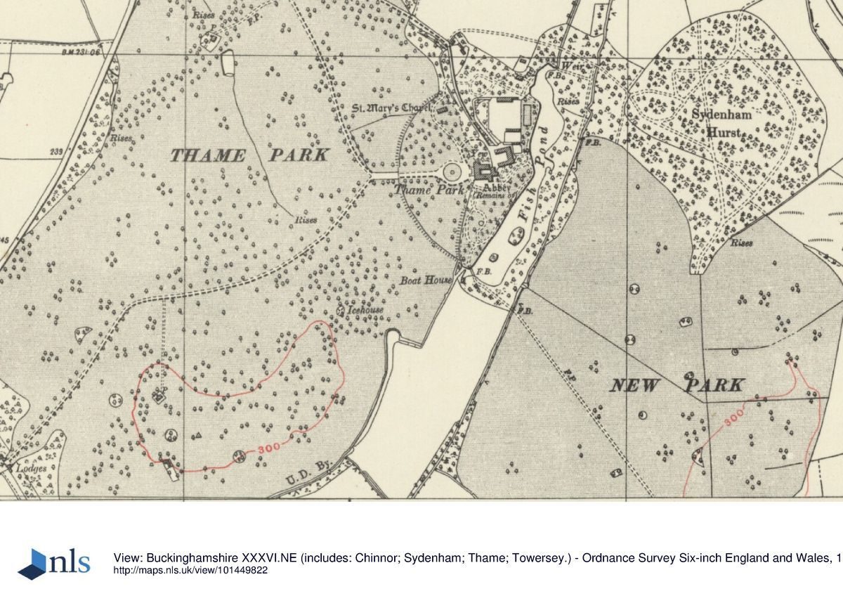
Thame Park lies 2km south-east of the centre of Thame, occupying c 210ha of largely flat land, with an elongated hillock in the southern half of the old park. The park is divided into two, the old park to the west, and the new park adjacent to the east, the whole being bounded to the west by the B4012 road running south from Thame to Postcombe, to the north by an arm of the Cuttle Brook (a tributary of the River Thame), and on the other sides by agricultural land. The setting is largely agricultural, with a late C20 light industrial estate 500m to the north, and extensive views south and east from the park towards the scarp of the Chilterns.
Entrances and Approaches
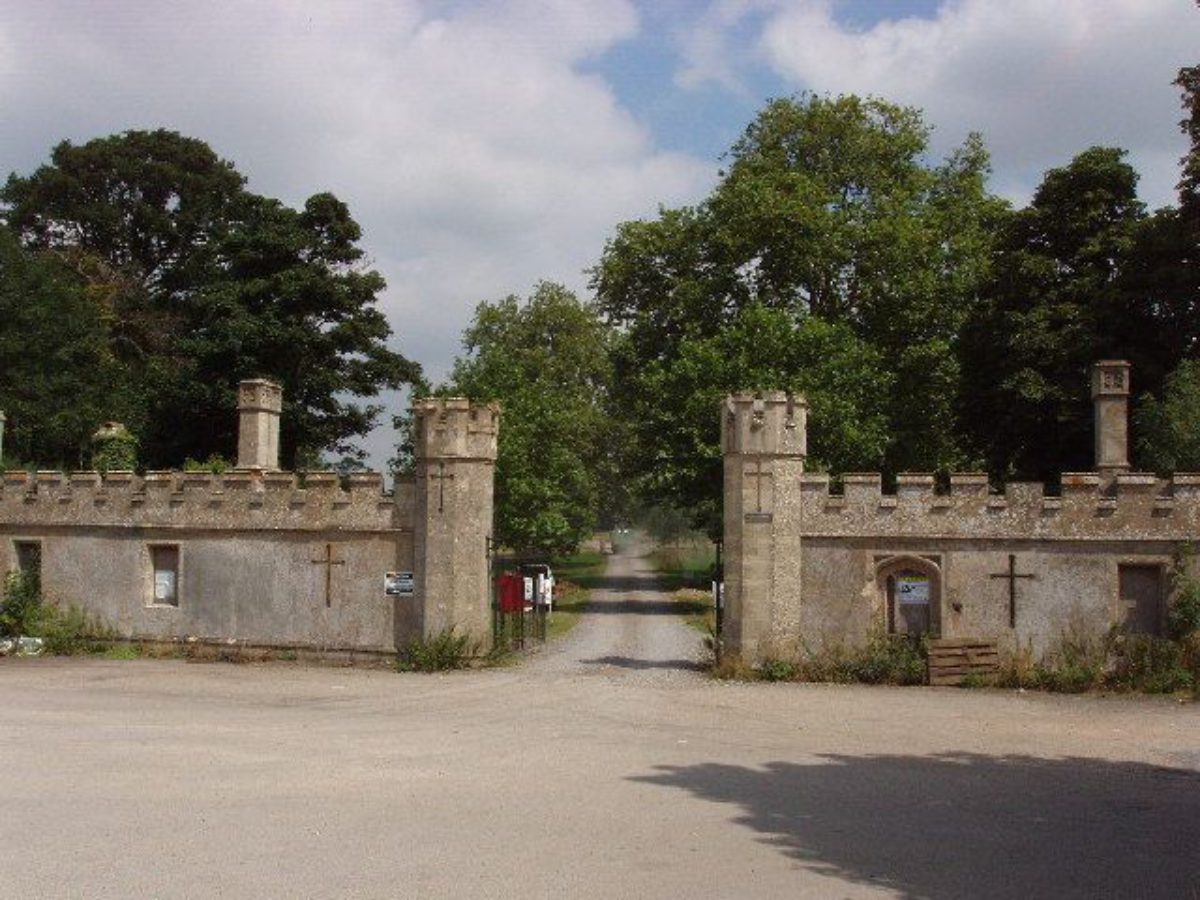
The main, north approach enters the park 1km north-west of the house, the entrance being set back off the A4012 and marked by a gateway screen with flanking lodges (c 1830s, listed grade II) in Gothic style. The rendered brick screen contains a central, raised carriage arch (castellated above) with smaller, flanking pedestrian gateways, all retaining cast-iron gothic gates. From here the north drive curves south-east through the park, turning east 250m west of the house, becoming a straight approach aligned on the main door, flanked by the remains of an avenue of horse chestnuts. The drive passes through a gateway (C19 with C18 gates, listed grade II) standing 170m west of the house, consisting of wrought-iron carriage gates flanked by pedestrian wrought-iron gates, hung from square stone piers attached to a screen of iron railings alternating with further stone piers. The drive divides to encircle a panel of lawn 30m from the west front on which stands a small, circular stone pond with the remains of a central fountain (mid C19, listed grade II), having lost its central statue of Mercury and eight peripheral cast-iron vases (mentioned in Listed Building Description but currently absent; thought to be in store, 1997). In the late C19 this lawn was divided into eight segments radiating out from the pond, probably separated by narrow gravel paths (OS 1881). The remains of two chestnut avenues, focused on the turning circle, radiate north-west and south-west across flanking lawns to north and south of the drive. The lawns, containing several other mature trees, are bounded to the west by a brick ha-ha, at the centre of which rises the gateway, and to the east by the pleasure grounds. East of the circular lawn a carriage sweep adjacent to the house is overlooked by a double flight of balustraded stone steps giving access to the central door on the first floor.
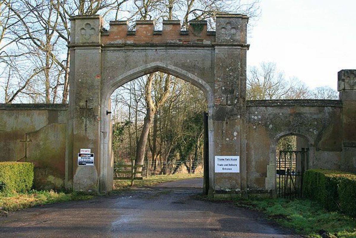
The south approach enters the park 1.3km south-west of the house, through a gothic, stone gateway with flanking lodges (c 1830s, possibly D Harris and R Abraham, listed grade II), the whole composition facing south-west along the B4012. The gateway is flanked by octagonal piers with battlemented tops, supporting wrought-iron gates with gothic tracery, attached to battlemented screen walls leading out to the small lodges concealed to the north of them. From here the south drive curves north-east, joining the north drive where it turns east 250m from the main front of the house.
A spur off the north drive 700m north-west of the house approaches the house from the north, acting as a service drive, passing the walled garden to the east and arriving at the stable court and service area east of the house. It is joined to the carriage sweep on the west front by a link drive curving around a shrubbery on the north front.
The current service drive appears in the late C18 to have been the main drive (the southern portion of the north drive is not shown), giving access to the north or east fronts of the house.
Principal Building
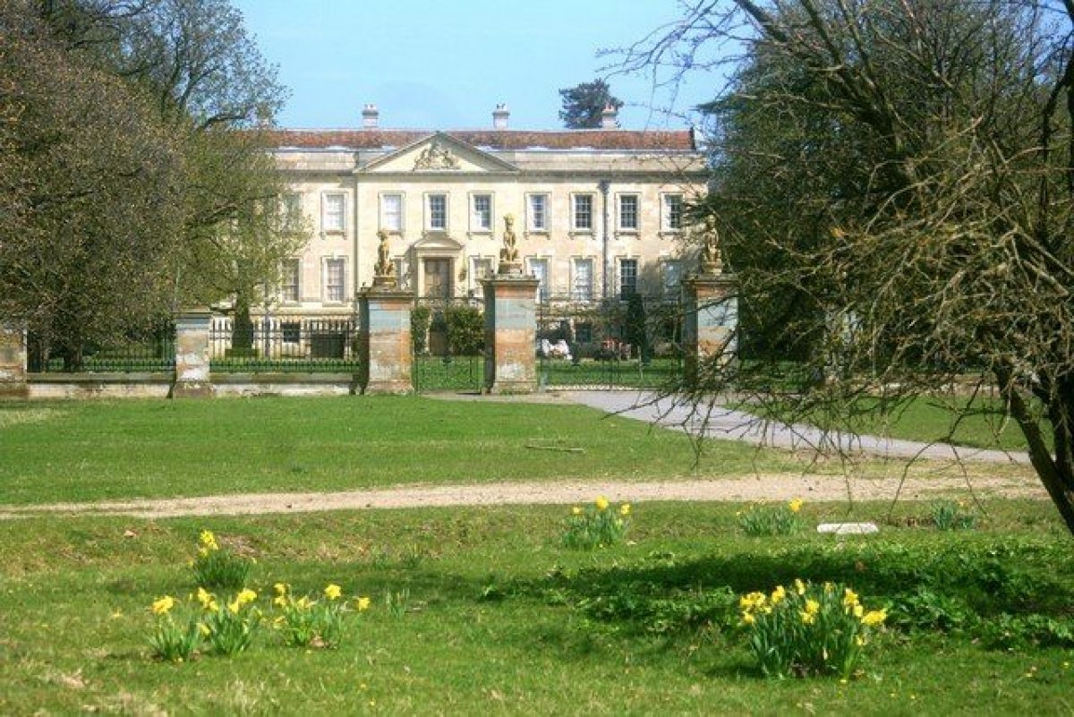
Thame Park (C14, C16, C18, listed grade I) lies at the centre of its pleasure grounds and park, connecting the old and new parks to west and east. The stone house incorporates C14 work in the north wing, C16 work in the fine Abbot's Lodging which forms the Tudor south wing overlooking the south lawn, and C18 work, possibly by William Smith of Warwick, in the west wing, built c 1745. This forms the main entrance front, with a piano nobile reached by the grand double staircase from the drive.
The stables (c 1745, probably William Smith, listed grade II) lying close by, 20m north-east of the house, are of two storeys. Built of coursed stone rubble with ashlar dressings, they form a square courtyard open on the west side, situated at an irregular angle to the house.
Gardens and Pleasure Grounds
The pleasure grounds lie to the north and south of the house, bounded to the west by the entrance lawns, and to the east by the sinuous Fish Pond and its adjacent screening woodland. An entrance at the south-west corner of the house, from the carriage sweep, gives access to the south lawn, overlooked by the Tudor south front with its low tower at the east end, and the C18 south elevation of the west range. The open lawn is bounded to the west by a screen of shrubs and trees, including yews, beyond which, along the southern half, lies the remains of a stone ha-ha. Upon the lawn stand several mature trees, including cedars of Lebanon, and several curving paths survive in outline. The lawn is dominated by the Fish Pond, with two islands towards the south end, where the water level is very low, and a wooden boathouse with a tiled roof standing at the southern tip.
A narrow ribbon of lawn continues north from the south lawn, along the west edge of the Pond, giving access to the northern pleasure grounds. These are bounded by the Pond to the east and north entrance lawn to the west, straddling the service drive from the north and encircling the walled kitchen garden. The lawn between the kitchen garden and the Pond retains traces of a formal layout, with, at the west boundary, inserted into the kitchen garden's east wall, a stone and rendered classical gateway with three arches on circular pillars (C19 or early C20), supported by taller, square, flanking pillars, reached up several broad stone steps. The walk continues north from here, turning west from the north end of the Pond (at this end almost full of water), passing a gabled Gothic-style cottage to the north. The broad grass walk continues west amongst dense shrub planting, crossing the drive into further shrubbery, emerging 150m north-west of the house at St Mary's chapel (early C14, remodelled 1836 by D Harris and R Abraham, listed grade II). This small stone chapel was probably built by the Abbey outside the gates as a travellers' chapel, being remodelled by Sophia, Baroness Wenman, when it was rendered and various gothic devices were added. The chapel stands at the west edge of the northern pleasure ground where it merges with the north approach lawn. The building is visible from the drive, and is linked by a curving path to the carriage sweep.
Park
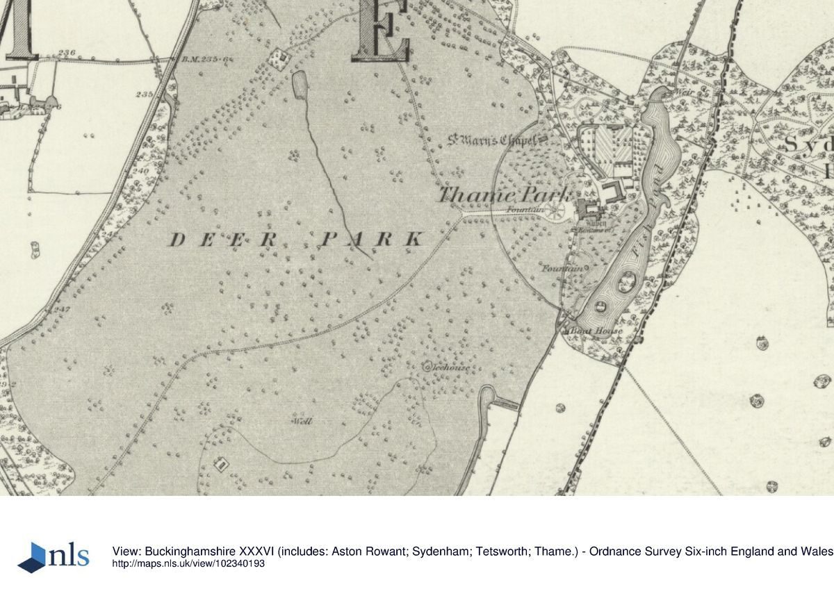
The park is divided into the old park to the west of the house and pleasure grounds, possibly based on a medieval park which continued west across the B4012, and the new park to the east, created during the C19. The old park, largely level north of the south drive, remains pasture with some arable, containing many mature specimen trees and clumps, and is bounded to the west by belts of trees, with intermittent open stretches. The elongated hillock in the southern section overlooks the new park to the east, farmland to the south, and parkland to the west and north. It contained an icehouse on its northern slope, some 400m south-west of the house (OS 1881), but no trace of this remains (1997).
The remains of a straight avenue of trees, aligned from the south-west boundary straight towards the south-west corner of the house, are shown on the 1881(2 OS map lying 0.9(1.2km south-west of the house, south of the current south drive. This feature corresponds with that shown on Davis' map of 1797, which shows a similar avenue. Almost all the trees of this feature have gone (1997). A straight double avenue close to the west boundary of the park lies 0.6(1km west of the house. Some mature trees remain, and traces of a platform between them can be discerned. Davis shows a park fence running along this alignment.
The new park, bounded to the north by Sydenham Hurst, a mixed woodland, is divided by several hedges, being mixed arable and pasture, retaining some mature single trees and clumps. It enjoys views east and south towards the Chiltern scarp, but is largely screened from the house and pleasure grounds by the belt of trees east of the pond. Late C19/early C20 mapping shows progressive planting of single trees and clumps, in addition to a few already existing small clumps, and the initial labelling of the New Park in 1901 (OS).
Kitchen Garden
The kitchen garden, with walls of brick and stone (C19, listed grade II), lies 70m north-east of the house, separated on its south side from the north wing of the stables by a short path, from which it is entered via a doorway in the wall. It is an irregular rectangle, having no south-west corner due to the presence of a canal running between the west wall and the service drive, which encloses the remains of an orchard. The walled garden retains on its north, heated, wall a series of ornamental, lean-to wooden glasshouses in poor condition, with attached chimneys rising above the wall behind them. The garden is largely laid to lawn, with perimeter and cross paths, all lined by clipped box hedges, the central north/south walk being flanked by trained fruit trees. The south-east corner is subdivided by brick walls, with further wooden glasshouses in poor condition on its north wall. It contains the remains of a formal layout, including four circular clipped box hedges enclosing beds and the classical entrance in the east wall from the lawn adjacent to the Pond.
Maps
- R Davis, A New Map of the County of Oxford ..., 1797
- A Bryant, Map of the County of Oxford ..., surveyed 1823
- OS 6" to 1 mile: 1st edition published 1881-2; 2nd edition published 1901; 3rd edition published 1921/2
- OS 25" to 1 mile: 1st edition published 1880
Description written: October 1997
Amended: March 1999
Edited: March 2000
- Visitor Access, Directions & Contacts
Directions
14 miles east of Oxford
- History
The following is from the Register of Parks and Gardens of Special Historic Interest. For the most up-to-date Register entry, please visit The National Heritage List for England (NHLE):
12th - 16th Century
Thame Abbey, an important Cistercian abbey founded around 1140 on the site of the present house, was acquired in 1547 by Sir John Williams, later Lord Williams of Thame. The greater part of the abbey buildings, including the abbey church, were either pulled down at this time or used as farm buildings. Upon Lord Williams' death in 1559, the estate was left to his daughter Isabella and her husband Sir Richard Wenman, in whose family the estate remained until the early 20th century. The Wenmans preserved the 15th/16th-century Abbot's Lodgings (now the south wing), together with the kitchen wing to the north.
18th - 19th Century
The sixth Viscount Wenman added a Palladian west wing in the late 1740s. The park was probably laid out in the mid- to late 18th century, seemingly covering part of an earlier park which stretched further south and west, across the Thame road. The serpentine lake was probably formed out of the monastic fishponds (Country Life 1957) at this time, too. Sophia Wykeham (died 1870), created Baroness Wenman in 1834 by William IV, restored the medieval chapel in 1836, embellishing it with further gothic decoration, at around the same time as she carried out major alterations within the house and constructed the entrance lodges.
20th - 21st Century
The estate was sold by Herbert Wenman Wykeham-Musgrave in 1917, passing then through various private ownerships and remaining privately owned (2024).
- Associated People
- Features & Designations
Designations
The National Heritage List for England: Register of Parks and Gardens
- Reference: GD2112
- Grade: II*
Features
- Lake
- Description: The serpentine lake was probably formed out of the monastic fishponds.
- Glasshouse
- Chapel
- Description: Sophia Wykeham restored the medieval chapel in 1836, embellishing it with further gothic decoration.
- Gate Lodge
- Earliest Date:
- Latest Date:
- Ornamental Pond
- Description: small circular stone pond with the remains of a central fountain
- Canal
- Brook
- Description: Cuttle Brook (a tributary of the River Thame)
- Ornamental Fountain
- Fishpond
- Kitchen Garden
- Key Information
Type
Park
Purpose
Ornamental
Principal Building
Domestic / Residential
Survival
Extant
Hectares
210
Civil Parish
Thame
- References
References
- {English Heritage Register of Parks and Gardens of Special Historic Interest}, (Swindon: English Heritage, 2008) [on CD-ROM] Historic England Register of Parks and Gardens of Special Historic Interest
- Pevsner, N. and J. Sherwood, {The Buildings of England: Oxfordshire} (Harmondsworth: Penguin, 1974), p. 808 The Buildings of England: Oxfordshire
- Lobel, Mary D. {Victoria County History: Oxford, Volume 7} (London: Oxford University Press, 1962) 168-77 Victoria County History: Oxford, Volume 7
- Lupton, H., (1860), pp 58-61 The History of Thame
- 26 (17 July 1909), pp 90-7; 122 (28 November 1957), pp 1148-51 Country Life, 26
- Clarke, G., (1978), pp 29-30, 55, 60 The Book of Thame
- Related Documents
-
CLS 1/45/283
Historic Landscape Management Plan - Hard copy
The Landscape Agency - 2002
-
CLS 1/45/284
Historic Landscape Management Plan - Appendices - Hard copy
The Landscape Agency - 2002
-
CLS 1/45/283