Introduction
Studley Royal has extensive pleasure grounds with an early geometric layout, a deer park with mixed styles, and includes the grounds of a medieval monastery.
The following is from the Register of Parks and Gardens of Special Historic Interest. For the most up-to-date Register entry, please visit The National Heritage List for England (NHLE):
Location, Area, Boundaries, Landform and Setting
Studley Royal lies c 3 km south-east of Ripon in a rural and agricultural area. The c 300 ha site is on land which falls from the north to the valley of the River Skell. The river runs through a valley which describes a curving course from west to east across the southern half of the site. The eastern boundary is largely walled with sections which could be the repaired and renewed survivors of a programme of wall building recorded in 1688. Part of the south-west side of the site is bounded by Abbey Wall which is a prominent skyline feature from the Abbey ruins, and other boundaries are largely fenced.
Entrances and Approaches
The principal entrance is from the west side of Ripon, south of Bishopton Bridge. A track leads south-west through a finger of parkland to East Lodge (listed grade II*). The design of this entrance has been attributed to the influence of Lord Burlington or Colen Campbell but it may be identifiable with a structure referred to in 1685 and probably predates John Aislabie's landscaping works of 1718 onwards. The gates lead to an avenue which runs south-west on rising land in alignment with St Mary's church (see below), and an Obelisk (listed grade II) of 1815 (now obscured by the church). The avenue is aligned with Ripon Minster (C13, listed grade I) c 3.5 km to the north-east and views of the Minster in the distance can be obtained from it. The route is diverted from its line to skirt to the south of the church and exit via a gate on the west side of the site.
On the north side of the site a drive leads from Galphay Road south to the B6265 where there is a set of gates, piers and flanking walls (probably mid C18, listed grade II). The drive continues south through the park and meets with the east drive at a point known as the Cocked Hat.
An entrance from the south-east tip of the site on Whitcliffe Lane leads to a drive which runs north and then turns to the west, following the line of the Skell. This part of the Skell valley is called Seven Bridges Valley for the succession of narrow rustic bridges over the river which winds through the valley. The bridges have fords across the river beside them (mid-late C18, bridges and fords all listed grade II) and they replaced wooden bridges in Chinese style built for William Aislabie c 1745. The route continues to the north-east tip of The Lake (see below) where it crosses the outflow via a bridge and runs north-west to join with other drives through the site.
Principal Buildings
Mackershaw Lodges (probably mid/late C18, listed grade II) lie on the highest point of the southern side of the site. A central arch is flanked by pedestrian gates and neo-classical lodges all built from roughly dressed stone. They are reached from a system of paths leading from Whitcliffe Lane in a position which was never a principal point of access, and they may have been primarily designed as an eyecatcher.
The Aislabies' house, which lay in the northern part of the park beside the north drive, was burnt down in 1946. The adjacent stable block (1728-32, listed grade II*) by Colen Campbell, was converted to dwelling and is in use as a private residence (1998).
Fountains Hall (listed grade I), which lies close to the south-west tip of the site was substantially remodelled 1598-1611 for Stephen Proctor and has a small walled garden on the south side. It was altered c 1930 and converted to an office and exhibition centre in the late C20, in which use it remains (1998).
St Mary's church (1871-8, listed grade I) was designed by William Burges for Lady Mary Vyner. The building is considered to be a triumph of High Victorian architecture and one of Burges' finest works.
Gardens and Pleasure Grounds
The site consists of three distinct but related areas: the northern parkland, the pleasure gardens to the south-west, and Seven Bridges Valley to the south-east. How Hill Tower (listed grade II*), c 1km to the south, is included as an outlying eyecatcher.
On the north side of the site the land falls to the south and open parkland is crossed by the two axial routes. The park is largely open pasture with scattered trees with a belt of planting sheltering the north-west side. The antiquarian John Warburton visited in 1720 and described 'a most delightful situation and park, which for variety of prospect in vistoes, avenues, fish ponds etc., is hardly to be exceeded or paralleled' (quoted in guidebook) which suggests that landscaping works were relatively mature and had probably been initiated in the last part of the C17.
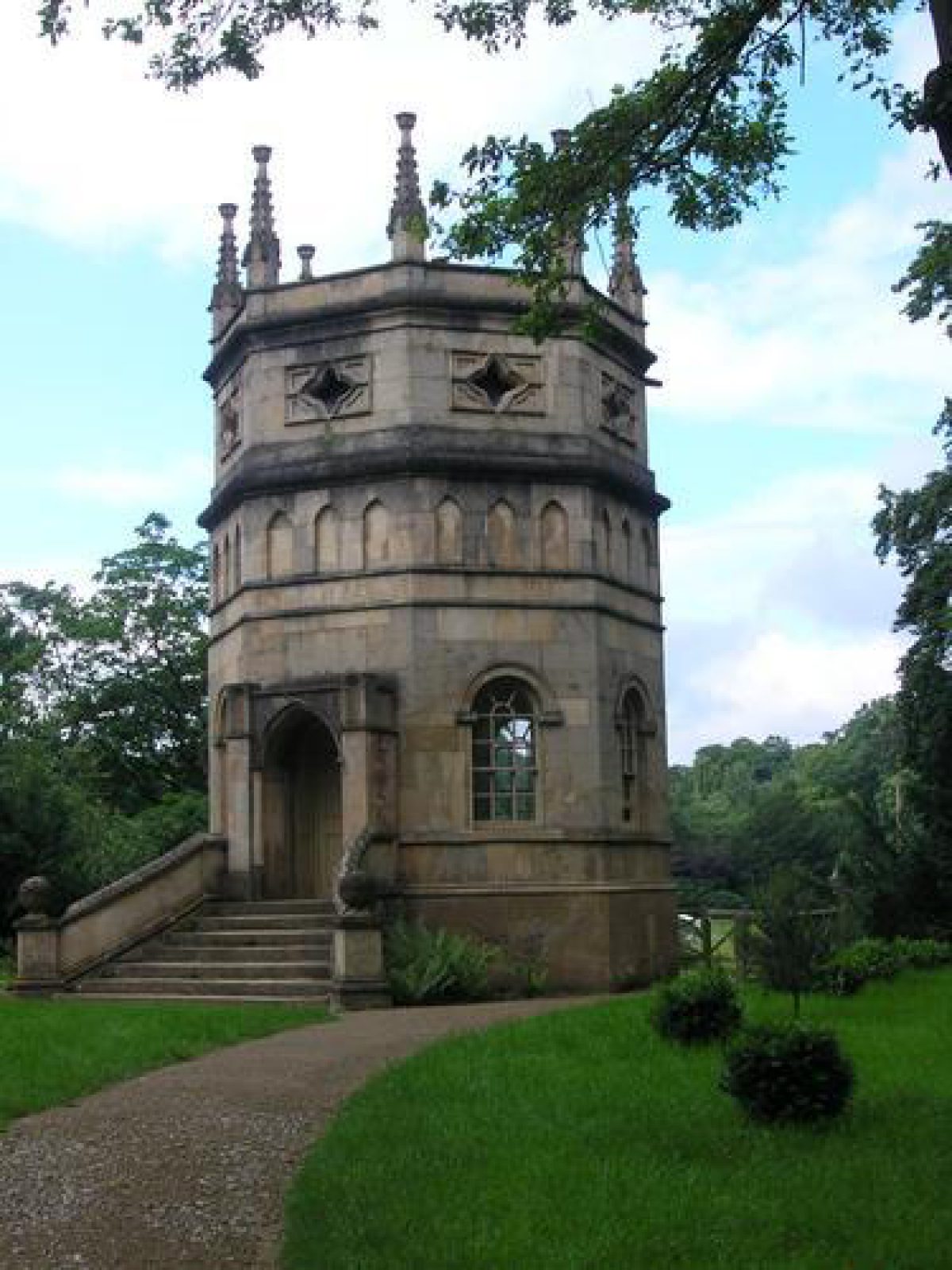
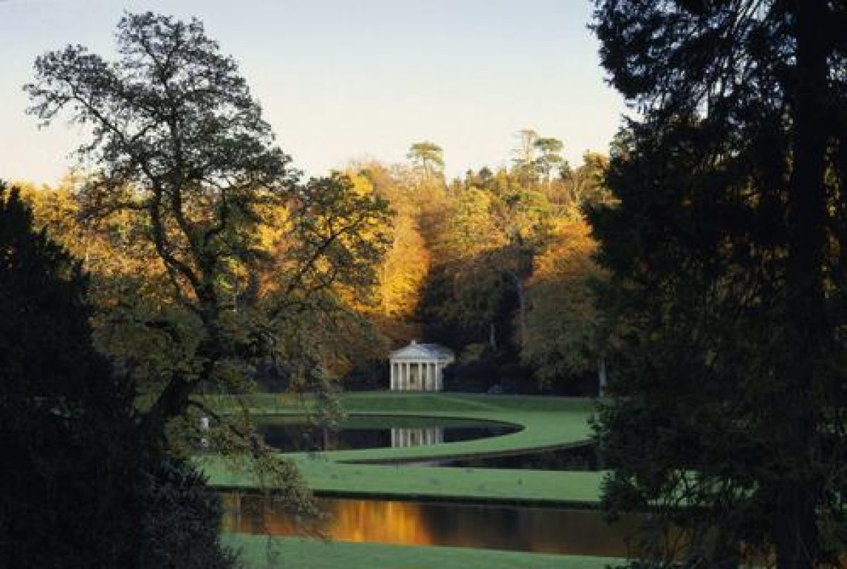
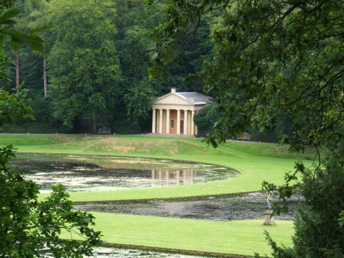
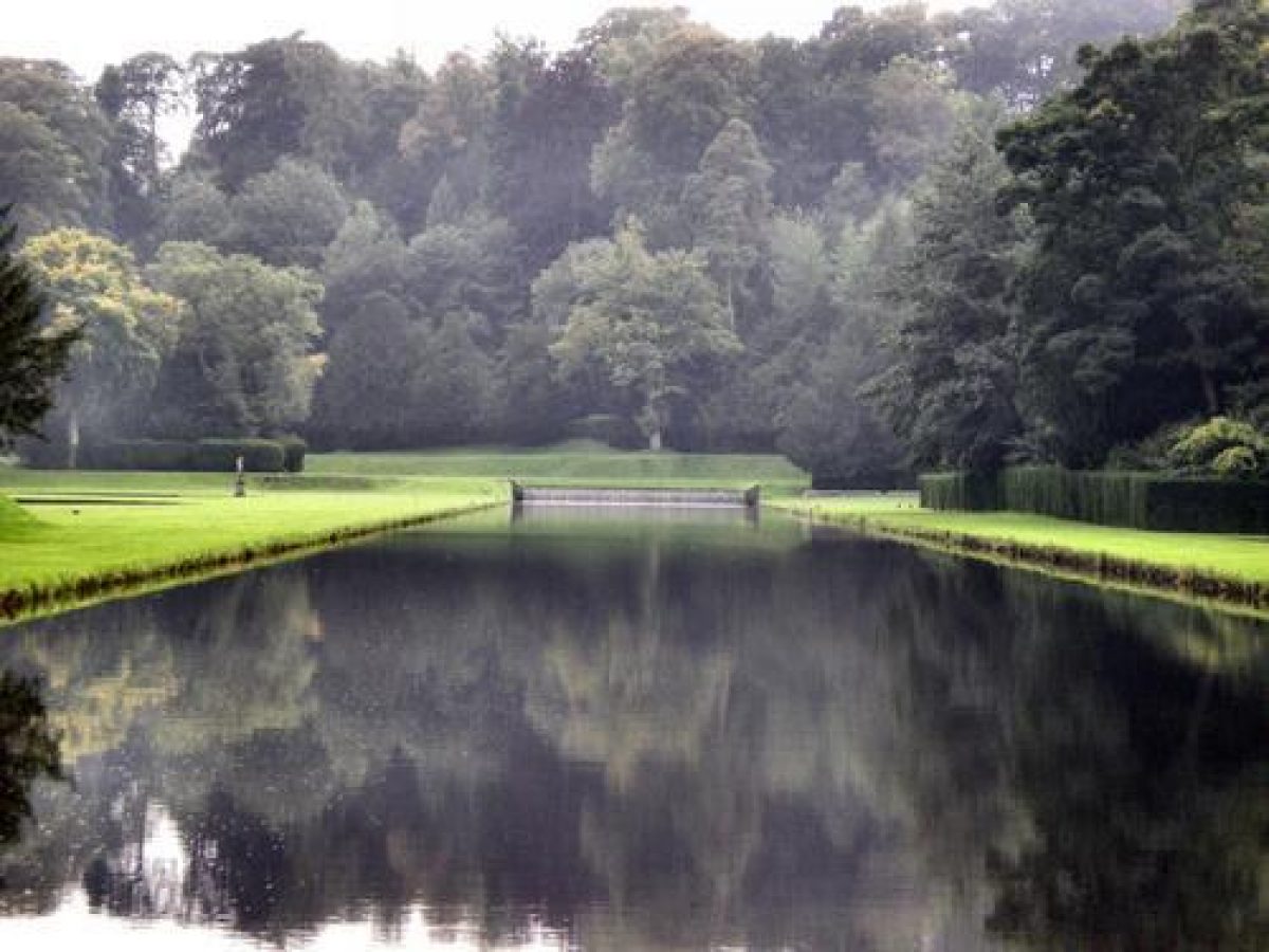
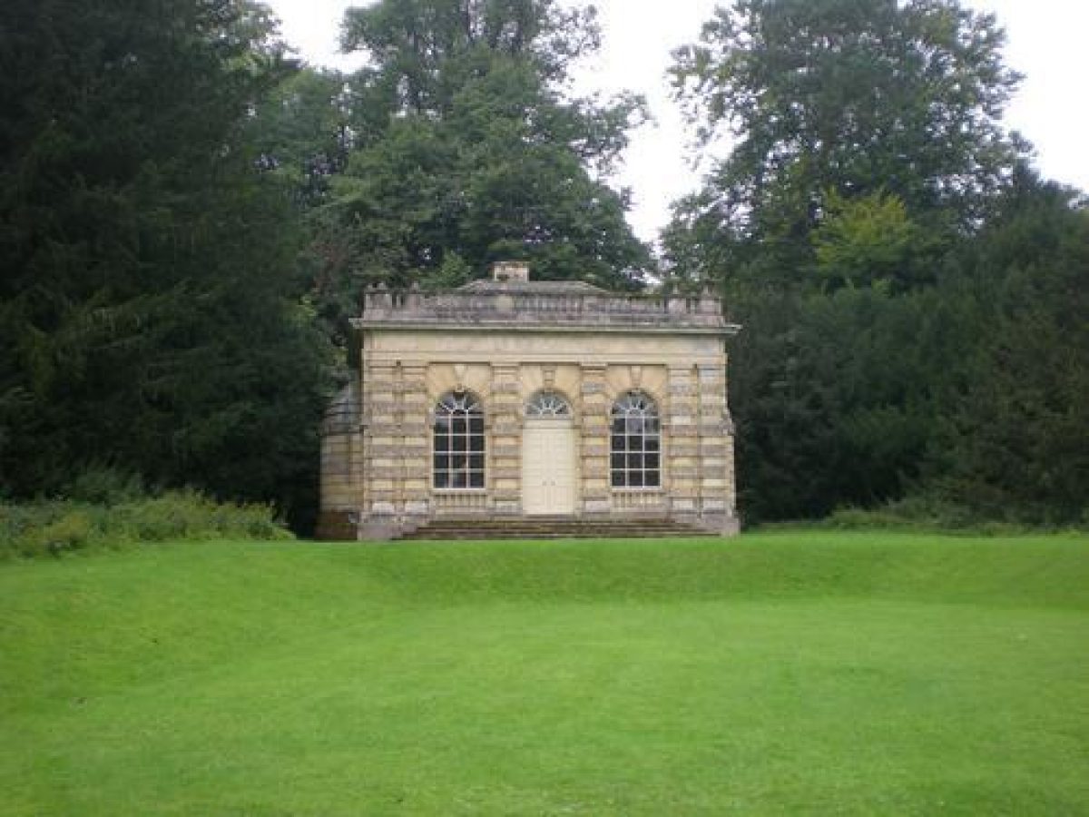
The central and south-western part of the site is the location of the pleasure grounds centring around the valley of the River Skell. The Lake is situated in low-lying land in the central part of the site. It has an island created from C19 dredging's and on the south side there is a dam with a central stepped cascade flanked by stone piers with frosted rustication and pavilions (1727-9, listed grade II*). Gates on the west side of the dam lead to a system of paths alongside The Canal (listed grade I), which runs south-west from the dam. The Canal is flanked by smooth grassed banks framed by the wooded valley sides. Some 100m south of the dam there is a semicircular lake called Half Moon Pond on the west side of The Canal, bowed inwards on its east side. The circular Moon Pond, c 220m south of the dam on the east side of The Canal, is flanked by the triangular Crescent ponds (Moon and Crescent Ponds listed grade II*) and the Temple of Piety (before 1738, listed grade I ) stands on its east bank. The wooded valley sides rise steeply to the east and west and there are views from the canal side to the Banqueting Hall (1728-32, possibly designed by Colen Campbell, listed grade I) high on the western valley side, c 300m south-west of the dam, and the gothick Octagon Tower (1735, listed grade II*) high on the east side c 100m south-east of the dam. The Canal turns through c 20 degrees at a point c 370m south of the dam where there is a cascade called Drum Fall, and it continues to a point c 500m south of the dam to a cascade, at which point it is crossed by Rustic Bridge (listed grade II). From this point the water sweeps in a smooth curve, called the Reservoir, around an eminence called Tent Hill and paths lead around the water's edge to run south-westwards as the ruins of Fountains Abbey come into view.
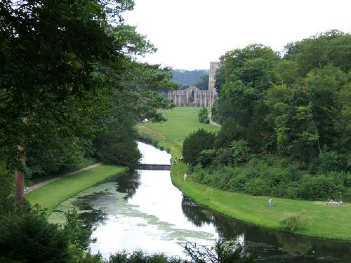
A system of paths leads through the woods and up the steep valley side on the east side of The Canal. A route leads across the dam and ascends the valley side entering a serpentine tunnel c 80 m south-east of the dam which emerges close to the platform on which the Octagon Tower stands. There are views from this point across the valley north-westwards to the Banqueting Hall. Tree-cover has partially obscured other long-distance views. The path, which is called High Ride, continues along the crest of the valley to the Temple of Fame (listed grade II), an open rotunda which was built in c 1770 by William Aislabie. Some 200 m south-east of this Anne Boleyn's Seat (late C18, rebuilt C19, listed grade II) is a shelter from which there is a striking view of the ruins of Fountains Abbey, seen for the first time from High Ride. The path loops down to rejoin the valley-bottom path leading to the Abbey ruins.
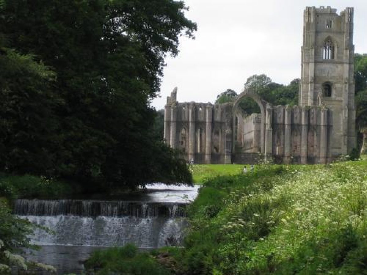
The Abbey ruins were cleared and consolidated by William Aislabie in a campaign which included the removal of the inner cloister wall, and the repair and re-erection of masonry. He built a raised platform, called the Gazebo (demolished), at the east end of the church which gave views of the ruins and out through the east window into the valley. Paths lead through the ruins and divide, with a yew-lined route leading west to Fountains Hall and another route leading east along the north side of the valley, completing a circuit walk back to the dam on The Lake.
The Seven Bridges Valley, on the south-east side of the site, is open grassland with scattered trees and clumps above the rocky valley sides to the north, and a band of woodland called Mackershaw Wood on the south valley side. A folly called the Roman Monument, also known as the Devil's Chimney (c 1740, listed grade II), tops a rocky eminence c 500 m east of the dam, and on the eastern edge of the site woodland on the north side of the river called Chinese Wood was the site of a large Chinese garden, of which little visible trace survives, laid out by William Aislabie in the 1740s with a pagoda and a Chinese pavilion.
Primary Sources
- M Newman, Archive Report (National Trust 1996) [An extensive and detailed study of the estate and its owners]
Maps [reproduced in National Trust 1997]
- Sketch map of gardens, 1738
- T Jefferys, County Map, 1771 Estate Map, 1831
- OS 6" to 1 mile:
- 1st edition surveyed 1854
- 2nd edition published 1910
Description written: December 1998 Amended: March 1999
Register Inspector: CEH
Edited: October 1999
- Visitor Access, Directions & Contacts
Website
https://www.nationaltrust.org.uk/visit/yorkshire/fountains-abbey-and-studley-royal-water-gardenAccess contact details
For more detailed visitor information visit the National Trust website for Studley Royal.
Directions
The site is off the B6265, 4 miles west of Ripon. There are bus services from Ripon and Leeds.
Owners
The National Trust
Heelis, Kemble Drive, Swindon, SN2 2NA
- History
The following is from the Register of Parks and Gardens of Special Historic Interest. For the most up-to-date Register entry, please visit The National Heritage List for England (NHLE):
Fountains Abbey was founded in 1132 and by the middle of the 13th century it was one of the richest religious houses in England. Following the Dissolution the buildings and some of the land was sold to Richard Gresham who later sold them to Stephen Proctor. After several changes of ownership the Abbey ruins and Fountains Hall were acquired by the Messenger family who sold them to William Aislabie (around 1700-81), owner of the adjacent estate of Studley Royal, in 1767.
George Aislabie acquired an interest in Studley Royal in 1663 when he married into the Mallory family. Work on the grounds at Studley were in hand before the end of 1674, but George was killed in the following year. The estate was consolidated in the years which followed and eventually devolved upon George's third son John (1670-1742) in 1693. John Aislabie's initially successful political career brought him into contact with William Benson, Clerk of the Office of Works and Benson's assistant Colen Campbell as well as John Vanburgh and Nicholas Hawksmoor. He had started work on the water gardens by 1718, which is the probable date of How Hill Tower (listed grade II*), an eyecatcher on the top of How Hill which has stylistic affinities with Vanbrugh's work at Castle Howard (see description of this site elsewhere in the Register). Work on the grounds stopped during the period 1721-3 when he was embroiled in the South Sea Bubble scandal, but operations recommenced and by 1730 the structure of the core part of the garden had taken shape.
John's son William Aislabie inherited and began extending the pleasure grounds into the eastern part of the Skell valley. Following the acquisition of the Fountains estate he incorporated the Abbey ruins into an extension of his father's garden. Studley became one of the premier sites to visit in the north and attracted a stream of visitors throughout the 19th century and into the 20th. After William's death the estate passed through the female line and eventually devolved upon the Vyner family who sold the site to West Riding County Council in 1966. The site is in the ownership of the National Trust (1998) which acquired it from North Yorkshire County Council in 1983. The south-east tip of the site, including Mackershaw and Chinese Wood, is in private ownership, as is Studley Royal House, and the eastern and northern approaches (1998).
- Associated People
- Features & Designations
Designations
The National Heritage List for England: Register of Parks and Gardens
- Reference: GD1376
- Grade: I
World Heritage Site
Plant Environment
- Environment
- Water Garden
Features
- Banqueting House
- Temple
- Description: Temple of Piety.
- Rotunda
- Description: Temple of Fame.
- Folly
- Description: Octogon tower.
- Woodland
- Description: Mackershaw Wood on the south valley side.
- Chinese Garden
- Description: On the north side of the river called Chinese Wood was the site of a large Chinese garden, of which little visible trace survives, laid out by William Aislabie in the 1740s
- Chinese Pavilion
- Description: Was located in the Chinese Garden.
- Pagoda
- Description: Was located in the Chinese Garden.
- Folly
- Description: A folly called the Roman Monument, also known as the Devil's Chimney (c 1740, listed grade II), tops a rocky eminence c 500 m east of the dam.
- Key Information
Type
Estate
Purpose
Ornamental
Plant Environment
Environment
Principal Building
Religious Ritual And Funerary
Survival
Extant
Hectares
318
Open to the public
Yes
Civil Parish
Fountains Earth
- References
References
- {English Heritage Register of Parks and Gardens of Special Historic Interest}, (Swindon: English Heritage, 2008) [on CD-ROM] Historic England Register of Parks and Gardens of Special Historic Interest
- Jellicoe, Sir G. et al (eds), {The Oxford Companion to Gardens} (Oxford: Oxford University Press, 1986), pp. 538-9 The Oxford Companion to Gardens
- Harris, J., {The Artist and the Country House} (London: Russell Chambers, 1979), pp. 194-5 The Artist and the Country House
- Pevsner, N., {The Buildings of England: Yorkshire The West Riding} (Harmondsworth: Penguin Books, 1967), pp. 502-4 The Buildings of England: Yorkshire The West Riding
- Holme, C. (ed), {The Gardens of England in the Northern Counties} (London: The Studio, 1911), plate 125 The Gardens of England in the Northern Counties
- Jarman, R and Lister J {The National Trust biological survey: Fountains Abbey and Studley Royal, North Yorkshire} (1988) The National Trust biological survey: Fountains Abbey and Studley Royal, North Yorkshire
- National Trust and English Heritage {Fountains Abbey and Studley Royal World Heritage Site Management Plan 2009-2014} (2009) Fountains Abbey and Studley Royal World Heritage Site Management Plan 2009-2014
- pp 300-6 A Six Months Tour Through the North of England, vol 2
- Observations on Several Parts of England 2
- Hussey, C., (1967) pp 132-9 English gardens and landscapes 1700-1750
- Goode, P., (1986) pp 538-9 The Oxford Companion to Gardens
- Studley Royal, guidebook