Introduction
Together with Pontcanna and Llandaff Fields, which opened later, Sophia Gardens forms a huge public open space in the heart of Cardiff, mirrored on the east bank of the river Taff by Bute Park. Although much of the original framework of Sophia Gardens has been lost, some original features remain.
Terrain
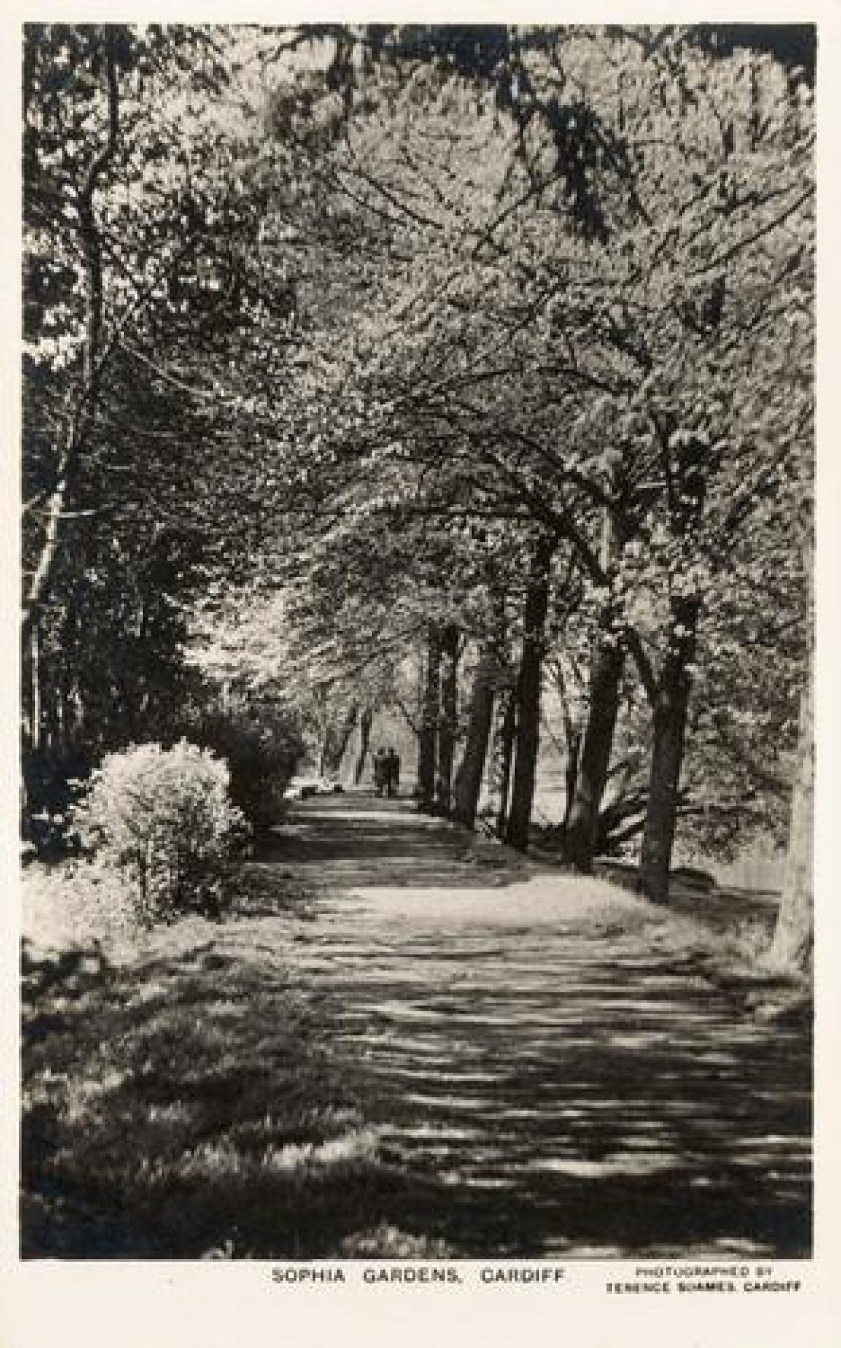
Most of the area lies on the flood plain of the river Taff.The area can be accessed from Cowbridge Road East adjacent to the river (The Taff Trail, here on a raised flood bank adjacent the river) and further west via the former main gates of the old park. From these gates a wide avenue of lime trees heads north-north-east to Sophia Close. The strip of land between the avenue and the Cathedral Road properties is grassed over.
Although once a formally laid out public park occupying about 18 hectares (see history section), the vast majority of this area has been developed, mostly for sporting activities.
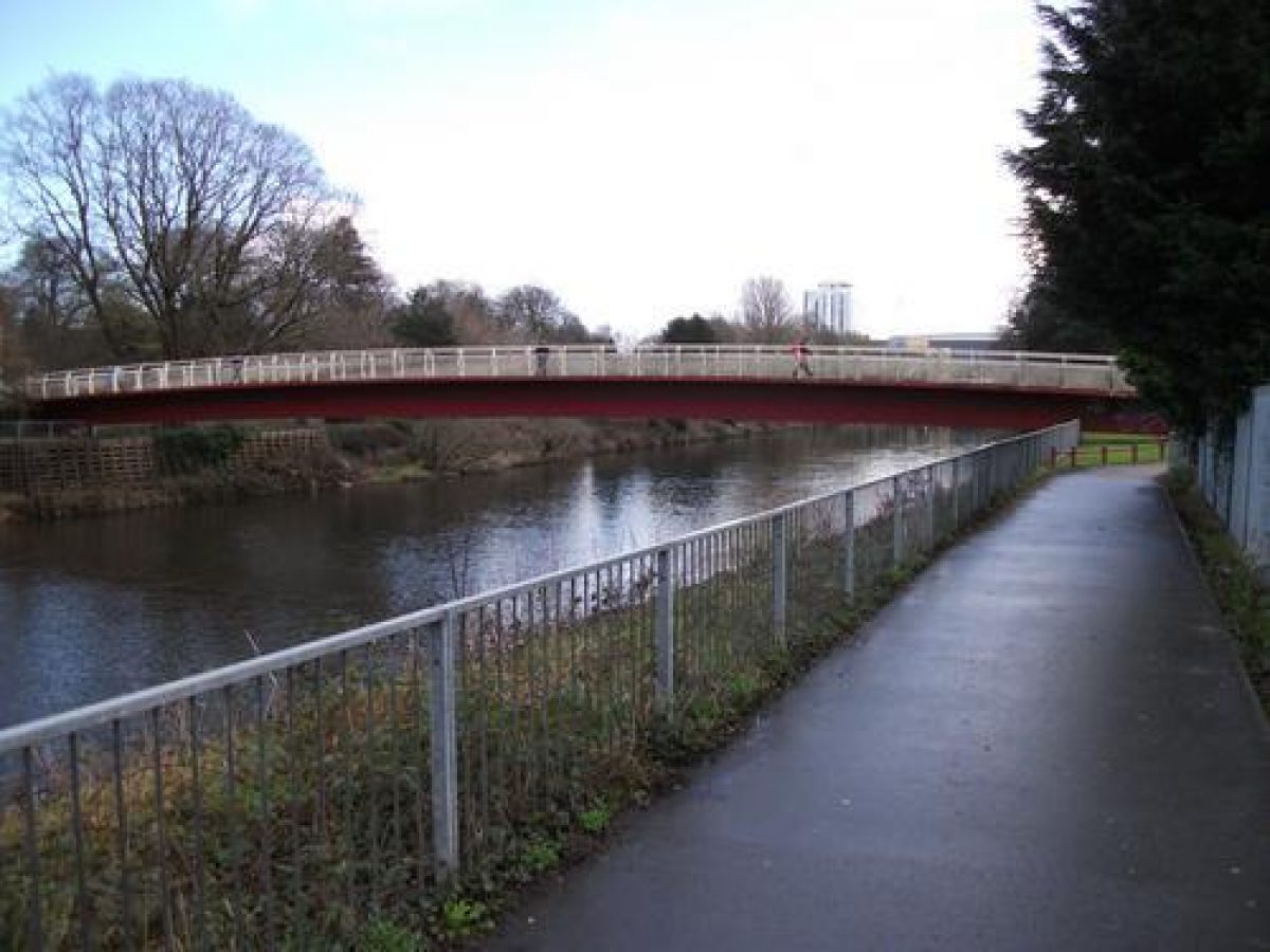
Adjacent to Cowbridge Road there is still a small area of grass with some trees. North of this is a car park. Close to the north-east corner of the car park the Millennium footbridge crosses the Taff into Bute Park. North-west of the car park is the site of Cardiff Bowls Club (indoor and outdoor). North-west and south-west of the Bowling Club compound is another small area of grass and trees crossed by a path joining the Taff Trail to Sophia Close. North of this a continuation of the avenue passes the Welsh National Sports Centre and associated car park, football and hockey pitches and the SWALEC Cricket Stadium. North-east of the SWALEC Stadium there is a stone wall which marks the boundary of Sophia Gardens. The avenue passes through an opening in this wall into Pontcanna Fields.
- Visitor Access, Directions & Contacts
Access contact details
Parts of this site are open to the public. The Taff Trail from Cardiff to Brecon also passes through the park.
- History
According to Pettigrew, Sophia Gardens was first noted as a public walk for Cardiff around 1857 and opened in 1858. It is named after Sophia Rawdon-Hastings, the widow of the 2nd Marquess of Bute who oversaw the creation of the park, which was built to compensate for the withdrawal in 1855 of public access to Cooper's Field and Castle Green. The layout was planned by the architect Alexander Roos. It was Cardiff's and Wales' first public park.
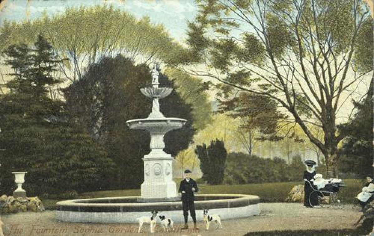
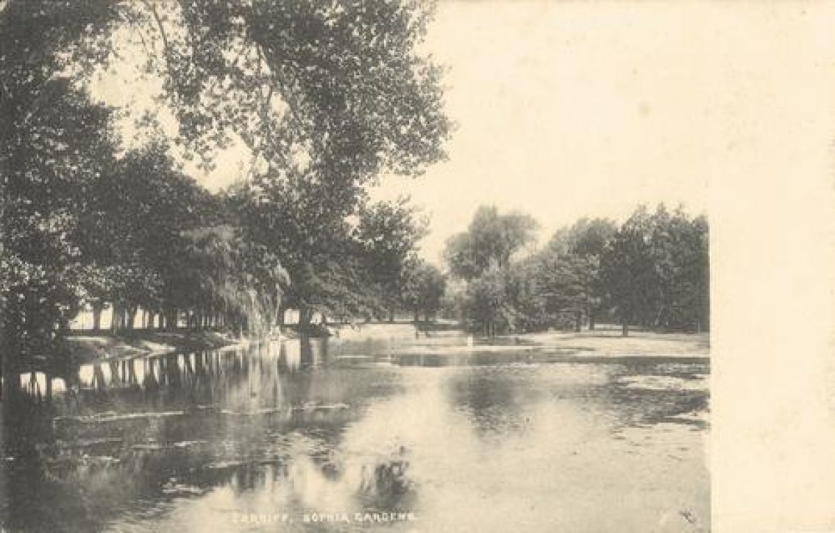
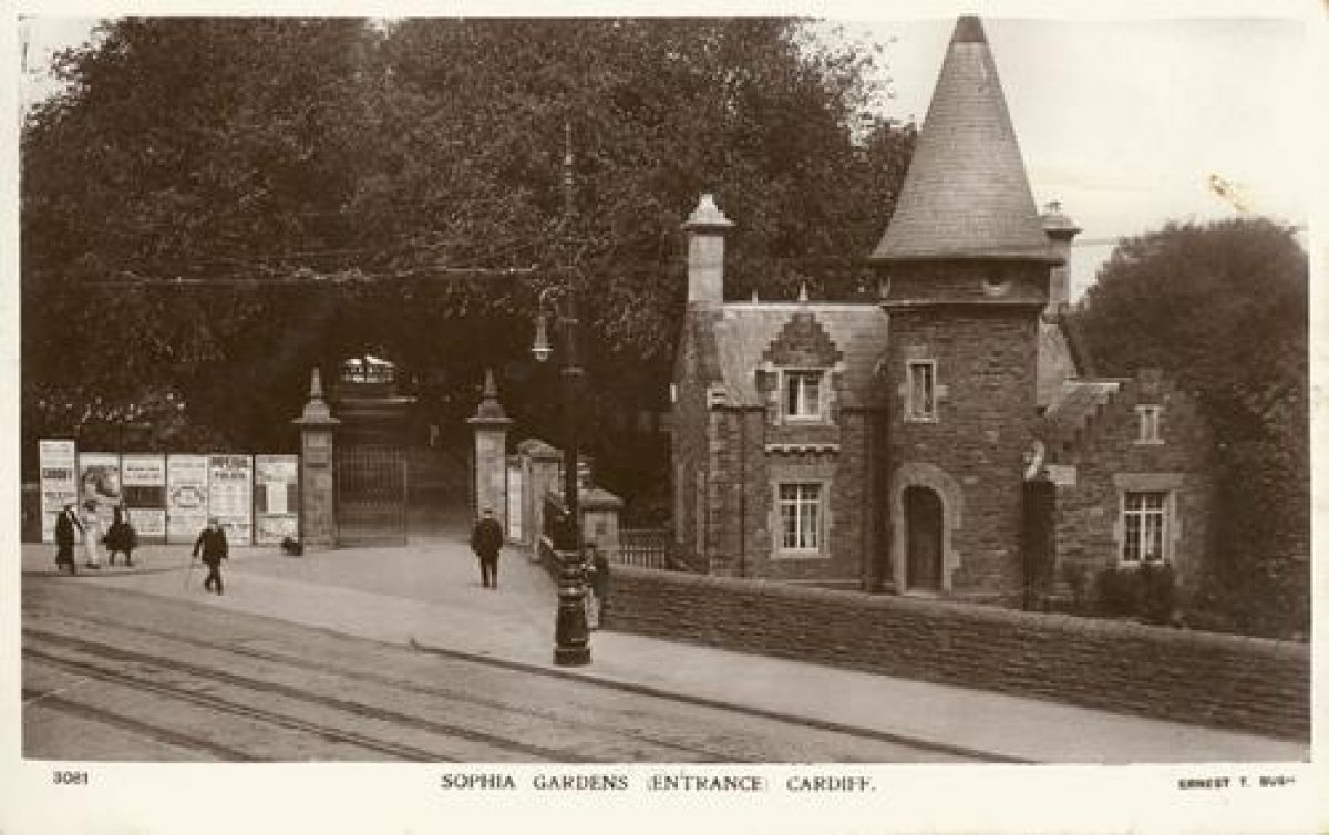
The original park occupied an area of 16 acres (6.5 hectares) stretching from Cowbridge Road East northwards for 640 yards (585 metres), between the banks of the river Taff and the prestigious properties on Cathedral Road, each of which had its own private entrance. The main entrance gateway was close to the junction of Cowbridge Road East and Cathedral Road, from which an avenue of lime trees lead northwards to a lake at the northern end of the park. The lake was fed by a pipe from the mill stream that (formerly) flowed across Pontcanna Fields. An elaborate lodge was built on the east side of the entrance. Pettigrew's account mentions the presence of flower beds in the park and bridges over the lake and that a fountain was erected in the park around 1859. The entrance gate and avenue of trees are still extant. At some stage in the early-20th century the lake was filled in.
1:500 scale Ordnance Survey Town Plans published in 1880 show the area east of the main avenue to be subdivided by paths into four areas, a triangular piece south and east of the lodge, two square shaped areas north of this between which, in a central location, stood the fountain and a more elongate area leading up to the lake. Each area was planted with areas of mixed deciduous and conifer trees. It also showed there to be an island at the northern end of the lake upon which there was a boat house. There was a path alongside the river which, from about the middle of the park northwards, was on a raised embankment. There was also a path around the lake. The park was accessible from the northern end via a driveway off Cathedral Road which terminated in a turning circle. This is the location of the modern day Sophia Close. A lodge was present on the north side of the Sophia Close turning circle which is still extant, having been converted into a wine bar.
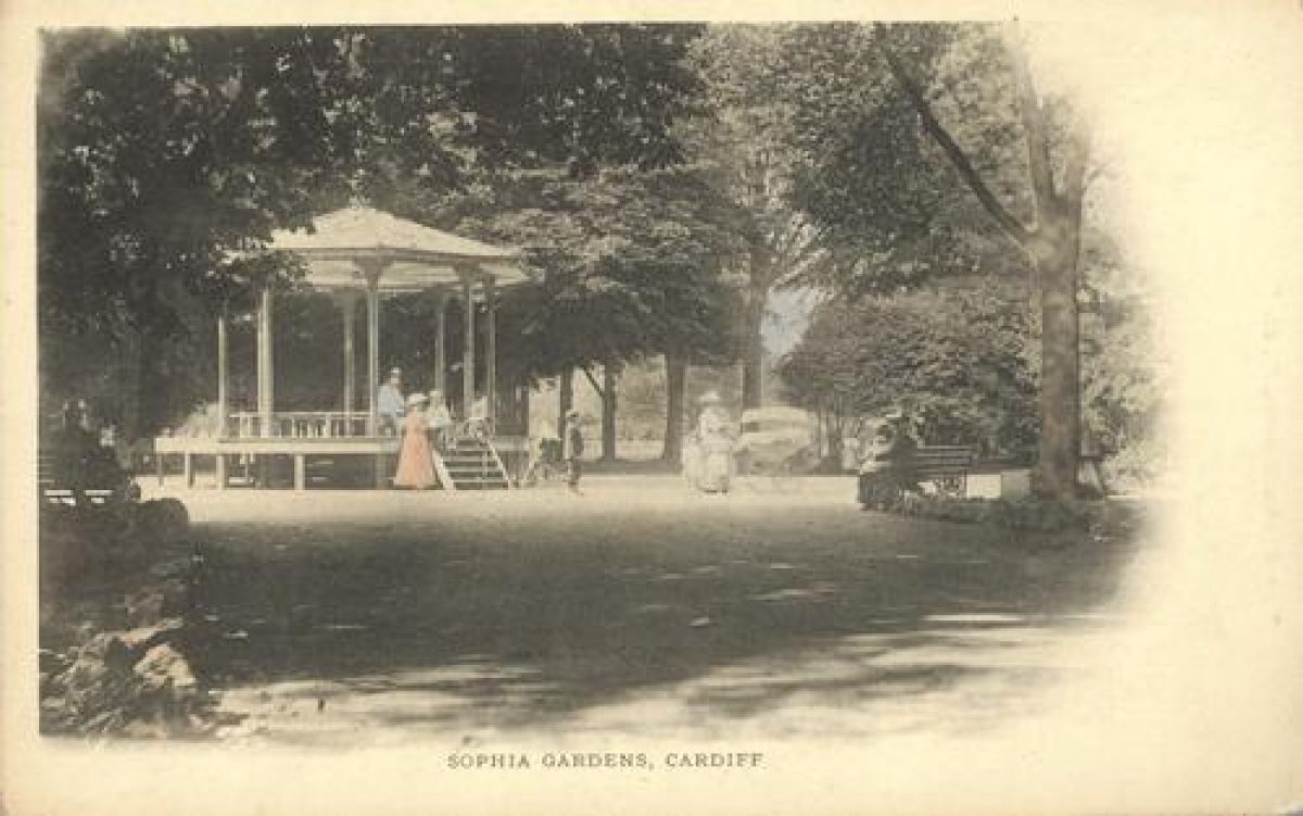
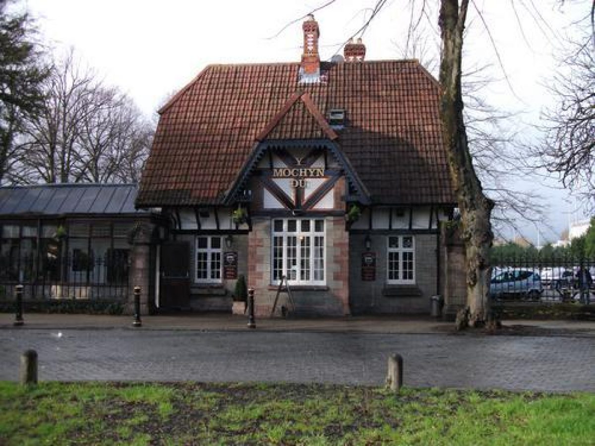
The park was extended northwards by a further 28 acres (11.3 hectares) into "Sophia Field" around 1879 and this area became a recreation ground with gravel tracks laid down for cycling around the edge. These features are shown on the 1:2500 scale Ordnance Survey plans dated 1901, which also show the presence of a bandstand north of the fountain and a bowling green in the older portion of the park, the latter being still extant. According to Pettigrew the green had been laid down with "Cumberland turf" in 1877/8 for the use of Cardiff Bowling Club. It was formally opened on June 5th 1878.
Over the years the park became the favoured location for a wide variety of functions and shows. Perhaps the most notable performance ever staged at the park was Buffalo Bill's Wild West Show, which came for a week in September 1891. The Western Mail, Tuesday, September 22, 1891, reported that up to 15,000 people attended the first performance.
Bute Park, Cardiff Castle and Sophia Gardens were gifted to the City of Cardiff by the fifth Marquess of Bute on September 10th 1947.
There is a photograph of the south lodge on the Cardiff Library website where it is stated that it was damaged by a bomb during World War 2. It was replaced by a bungalow in 1951 when the large Sophia Pavilion (hall) was erected south of the bowling green at the location of the present day car park. This was used for many years to stage large entertainment functions and shows, though its last function was a night club. The roof of the pavilion collapsed under the weight of snow in January 1982, fortunately at a time when it was unoccupied.
Glamorgan Cricket Club transferred their ground from Cardiff Arms Park to the north end of Sophia Gardens recreation ground in 1966. The stadium was completely redeveloped between 2005 and 2008.
The National Sports Centre for Wales (now Sport Wales National Centre) and associated car park and hockey and football pitches was constructed on the remainder of the recreation ground and was officially opened by Prince Charles on June 12th 1972.
The area had always been at risk of flooding, serious floods having occurred in the 20th century in 1927, the 1960s and 1979; the latter prompted the instigation of an extensive flood protection scheme in 1982, when the present day river banks were engineered.
The Millennium footbridge, which links Sophia Gardens and Bute Park, was constructed in 1999.
References
Pettigrew, A. A. "The Public Parks and Recreation Grounds of Cardiff". 1926 revised 1933-4, Vol I, p38-53. Original manuscript version consulted. Cardiff Local Studies Library.
www.cardiffians.co.uk
www.glamorgancricket.com
www.cardiffparks.org.uk/sophia/index.htm
http://www.cardiff.gov.uk/content.asp?nav=2870,3139,3158,3964&parent_directory_id=2865&id=507
http://www.coflein.gov.uk/pdf/CPG210/http://ibistro.cardiff.gov.uk/uhtbin/cgisirsi/KCK9f43UcO/CENTRAL/94680019/9
Period
- Post Medieval (1540 to 1901)
- Victorian (1837-1901)
- Associated People
- Features & Designations
Designations
Conservation Area
- Reference: Cathedral Road
CADW Register of Landscapes Parks and Gardens of Special Historic Interest in Wales
- Reference: PGW(Gm)21(CDF)
- Grade: II
Features
- Lawn
- Description: Cricket ground. This is a new stadium completed in 2008.
- Key Information
Type
Park
Purpose
Recreational/sport
Principal Building
Parks, Gardens And Urban Spaces
Period
Post Medieval (1540 to 1901)
Survival
Extant
Hectares
6.5
Open to the public
Yes
Civil Parish
Riverside
- References
References
- CADW, {Register of Landscapes, Parks and Gardens of Special Historic Interest in Wales: Glamorgan} (Cardiff: CADW, 2000) 78 Register of Landscapes, Parks and Gardens of Special Historic Interest in Wales: Glamorgan
- Pettigrew, A., {The Public Parks and Recreation Grounds of Cardiff, Vol. 2} (1926) 99-130 The Public Parks and Recreation Grounds of Cardiff, Vol. 2
- Pettigrew, A., {The Public Parks and Recreation Grounds of Cardiff, Vol. 1} (1926) 38-53 The Public Parks and Recreation Grounds of Cardiff, Vol. 1
Contributors
Michael Statham