Introduction
Snowshill Manor is an early 20th-century terraced garden on steeply sloping ground.
Terrain
Steeply sloping site.The following is from the Register of Parks and Gardens of Special Historic Interest. For the most up-to-date Register entry, please visit The National Heritage List for England (NHLE):
Early 20th-century terraced gardens on steeply sloping ground, laid out by Charles Paget Wade and associated with a Cotswold manor house of around 1500 and later.
Location, Area, Boundaries, Landform and Setting
The village of Snowshill lies 11km south-east of Evesham. The Manor stands to the north of the village, on a minor road connecting Broadway, to the north, to the B4077. The registered area, of 0.8ha, is bounded by stone walls, hedges, wooden fences and, to the east, by the minor road. The western half of the north boundary of the Manor garden is formed by a holly hedge, the eastern section being defined by a 2.5-3m high stone wall. The public house, the Snowshill Arms, marks its southernmost extent. The Manor lies on sloping ground which drops away to the west, before rising again, towards the village of Stanton, c 2.5km away. There are extensive views of the hillside to the west from much of the garden. To the east of the Manor, the land rises more gently, up to Spring Hill.
Entrances and Approaches
Before 1995, the Manor was approached from the village, through a wooden gate in a stone wall between a pair of stone gatehouses (previously stables) c 60m south of the Manor. A visitors' car park was built at Piper's Grove, c 250m north-west of the Manor, in c 1995, from where a winding gravel footpath leads to the south front of the Manor.
Principal Building
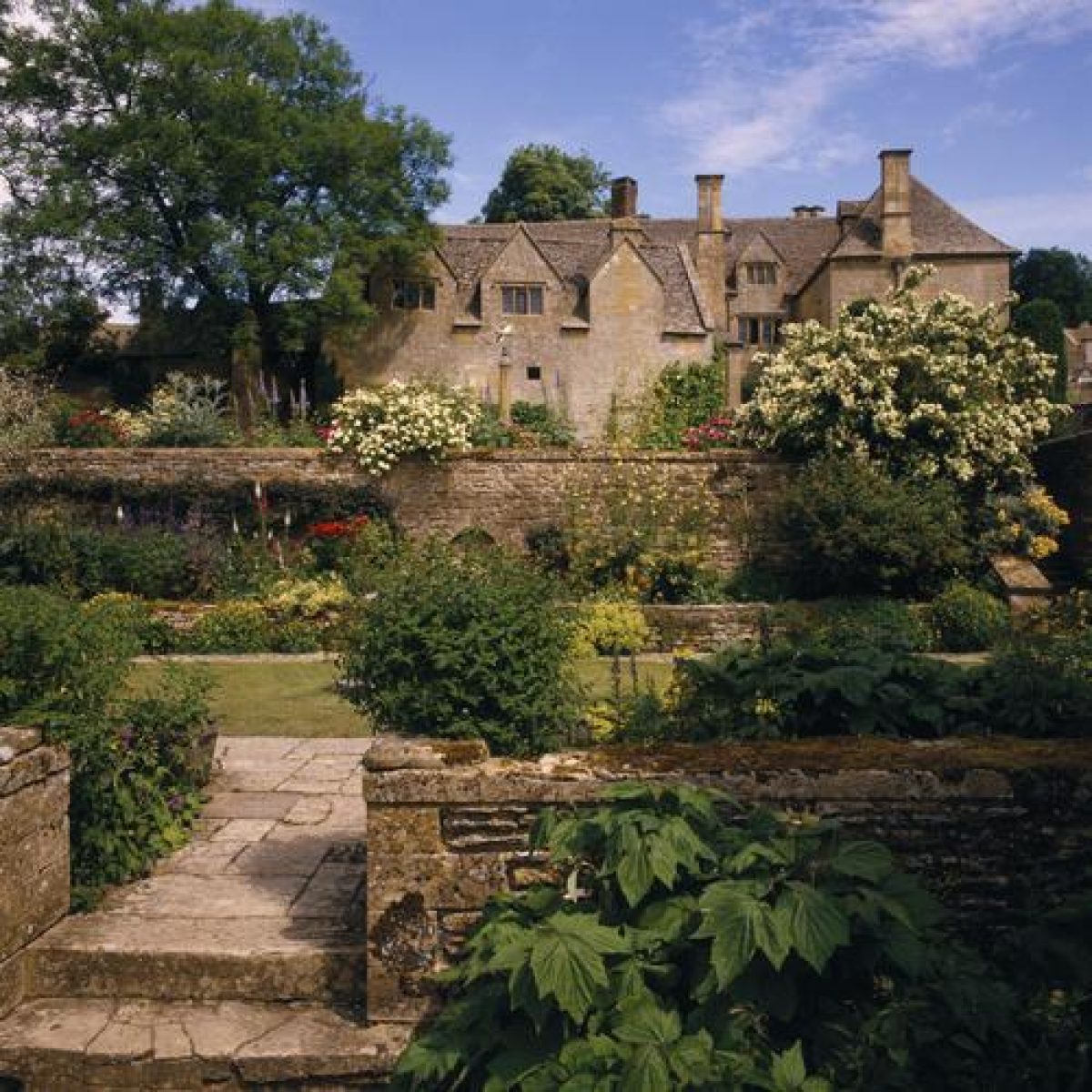
Snowshill Manor (listed grade II*) is a Z-plan house of two-and-a-half storeys, built of coursed, squared Cotswold stone with stone slate roofs. Its earliest part is the north hall of c 1500, converted to two storeys in c 1600. In 1712, William Sanbach altered the south end and added a projecting room to the west to give a classical front. The original front door, in the middle of the west side, is now partially obscured by an early C18 gazebo room and the present front door is off-centre, on the south face of the Manor. Repairs and alterations were made for and by Wade from 1919 to 1923.
Gardens and Pleasure Grounds
Snowshill Manor stands in the north-east corner of its gardens, which form an irregular square. The gardens are laid out in a series of walled compartments, linked by flights of stone steps, on three main terraces to the west of the Manor and three terraces to the south and south-west. Most of the many wooden gates and seats in the gardens have been painted 'Wade Blue', a deep-turquoise colour.
Within the registered area is a small, tapering strip of grass (20m long and 1-3m wide) between the east side of the Manor and the minor road. The south front of the Manor is approached by a gravel path which starts at a wooden gate, c 50m from the south end of the house. The gateway pierces a c 2m high ashlar wall between two C17 single-bay, coursed stone lodges with stone slate roofs (wall and lodges listed grade II). These were formerly stables, altered in the C18 and early C19. The church of St Barnabas can be seen through the gate. The gravel path, c 1m wide, runs north, through two forecourts, each c 25m long and 12m wide, which are divided by a yew hedge c 1.5m high, pierced by a wooden gate between c 3m high ashlar stone piers surmounted by ball finials (c 1720, listed grade II). These piers represent the original road boundary of the property. The southern compartment contains mature beech, holly, yew, hornbeam, and sycamore trees whilst the northern compartment, next to the Manor, has lawn to each side of the path, with a mature bird cherry in the south-east corner. The east side of these compartments is bounded by a c 3m high coursed stone wall whilst a 0.5-1m high wall (of coursed stone to the north and drystone to the south) supports the western edge of the terrace. From the northern compartment, there are extensive views of the valley and opposite hillside to the west.
Stone steps leading north from the south-west corner of the Manor give access to a stone-flagged area which forms the north end of a second terrace, c 4m wide, adjacent to, and west of, the first. This terrace is of mown grass, with a mulberry and two hornbeams planted along its eastern edge. A grass ramp along its western edge connects it to a third, parallel, grass terrace, c 6m wide, c 1.5m below. A short flight of stone steps at the northern end of the middle terrace also links the two terraces. A wooden post and rail fence forms the western boundary of the lowest terrace and divides it from an orchard, which is entered via a wooden gate in its north-east corner. A hornbeam hedge separates the bottom terrace from the gravel path which runs along the southern ends of the terracing and orchard.
From the northern end of the middle terrace, stone steps lead from the paved area to a gravel path which runs west for c 40m, between the orchard (here contained by a wooden fence fronted by a hawthorn hedge) and the c 2.5m high coursed stone wall of the main garden. The path is edged by narrow herbaceous borders with stone edges. About halfway along the wall, an arched gateway leads to the Armillary Court. At its western end, the wall joins a further 12m length of walling, running north. A stone shed, built into the corner where the walls meet, is accessed via a door at the west end of the south wall. The shed is connected to a stone dovecote to its north, the entrance to which is a small wooden door in the western garden wall. The gravel path turns north to follow the wall, here also edged with herbaceous borders, and with a herb garden. A yew hedge divides this area from the kitchen gardens to the west. To the north of the dovecote, three semicircular stone steps lead up to a wooden gate between two 3m high ashlar gate piers with ball finials (Wade c 1920, listed grade II). East of this is the Well Court.
At the south-west corner of the Manor, the garden wall is pierced by a gateway with a wooden gate, leading to the Cottage Court. A quote painted on a board (probably early C20) above the gateway reads: 'A gardyn walled all with stoon, so fair a gardyn wot I nowhere noon'. This is one of several such quotes sited in the gardens. Some 3m north of the gate and 10m from the west front of the Manor, is the Brewhouse (also known as the Priest's House or Cottage, listed grade II). This C16 and C17 coursed stone building was once a dairy, then a still room, then Wade's house. It was altered and extended in the C19 and from 1919 to 1923, by Wade. A painted wooden sculpture of St George and the Dragon (1922) is mounted on its south end and is visible through the gateway, from the middle of the southern terraces. Between the Brewhouse and the Manor is an area of lawn (c 10 x 5m), divided by a flagged stone path which leads from the paved area at the south end of the Cottage Court to the northern extension of the Brewhouse. A low stone wall divides a raised lawn (4 x 2m), against the north-west corner of the Manor, from the rest of the Court. A coursed stone wall c 2.5m high forms the boundary between the terrace and the Administrator's Garden (private), a square lawn edged by trees, to the north.
Three short flights of stone steps lead from the south end of the Brewhouse, west, down to the Armillary Court, past two Irish yews planted against the wall opposite the Brewhouse. The path divides, one arm continuing west, as an axial path, down steps spanning a c 2m drop, to the south end of the Armillary Court, whilst the other arm turns north to run along a raised stone- flagged walk west of the Brewhouse, with a low stone wall on its west side and a viewing area halfway along, overlooking the Armillary Court.
The east/west axial path passes through an avenue of nine (originally ten) Irish yews at the south end of the Armillary Court. The Court (c 9 x 10m) is mostly taken up by a rectangular lawn, surrounded by a stone-flagged path, with a central Armillary Sphere on a tall stone column. There are narrow herbaceous borders between the path and the stone walls which enclose the Court on its north, east, and west sides. A bronze head of Bacchus, mounted halfway along the eastern, drystone wall directly below the viewing area, drips water into a lead tank beneath.
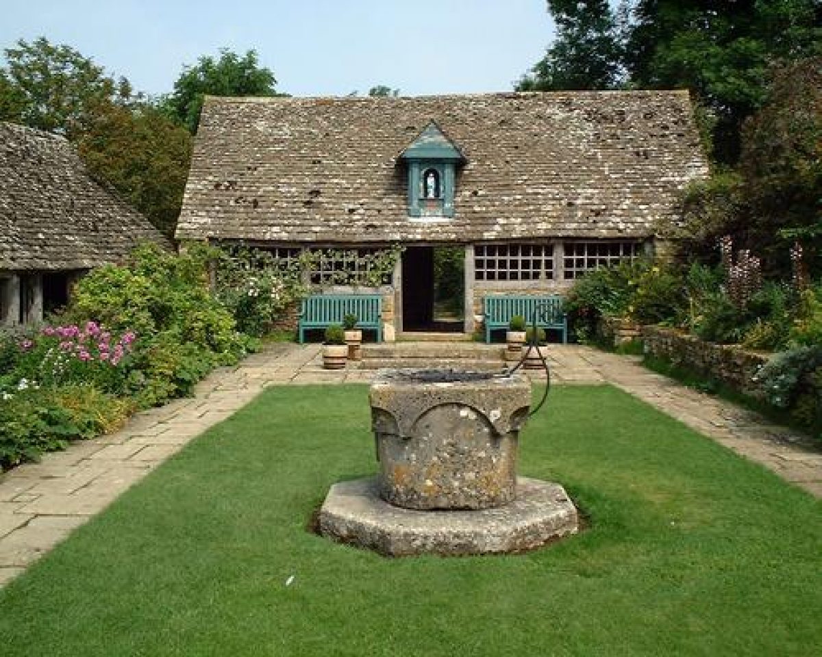
The axial path from the south end of the Brewhouse continues down stone steps to the Well Court (c 5 x 11m), which runs parallel to the Armillary Court. This enclosure has a narrow rectangular lawn with a Venetian stone well-head in the centre. At its southern end, steps lead up to a small paved raised terrace from which the Court can be viewed. The points of the compass can be seen in the paving here. On the north wall of the terrace is mounted a Zodiac Clock (in Wade Blue) and, beneath this, a wooden bench is set into an alcove. A raised bed, held up by a low stone wall, runs along the eastern edge of the terrace. At two points along the wall behind this bed, water drips into decorative lead troughs. In the south-west corner of the Well Court is the Dovecote (late C16 or C17, listed grade II), of roughly squared, coursed stone with a stone slate gabled roof. The stone wall, pierced by the gateway with the semicircular steps, connects this to a garden house (listed grade II) c 8m to the north. Between these two buildings is a herbaceous border, divided by a path leading to the kitchen garden. Another garden house (listed grade II), known as the Sancta Maria Byre, forms the northern boundary of the Well Court. Both were formerly cowhouses of the late C18 and early to mid C19, probably altered by Wade c 1919-23. The east side of the garden house, nearest to the Dovecote, is open, giving views of the Well Court. The Elder Grove and open countryside beyond the garden can be seen through a doorway in its north wall. To the south of the Sancta Maria Byre a square pool is sunk into a small paved sitting area and reflects the small Madonna shrine set on the roof of the garden house.
A route through the Sancta Maria Byre leads to the Elder Grove beyond (now of Guelder roses - the elders were lost in the winter of 1963): a rectangular compartment, quartered by stone-flagged paths. It is enclosed by drystone walls to the north, east, and west. At the northern end of the Brewhouse, this path leads up a flight of stone steps with a c 3m high stone pillar, with ball finial, to the west. The steps lead to a grass terrace (c 4 x 12m) running north/south, backed to the east by the stone wall of the Administrator's Garden. Four ash trees, one of which is mature, grow along the wall. There is a curved wooden seat on a raised grass platform in the north-east corner of the terrace.
Access to a second, lower grass terrace is at the northern end of the upper terrace. The second terrace then slopes gently downhill, from north to south. A grass bank divides the two terraces. Below this is a series of informal terraces (some edged by drystone walls) across which grass walks, between trees and shrubs, lead back to the Armillary Court. Adjacent to the north end of the Armillary Court is a deep, stone-edged, square trout pond which once formed the quay for Wade's model Cornish village (one model building remains) which John Betjeman, a frequent visitor, wrote about in 1932 (Architectural Review). There is a gate in the pool's south wall, connecting it to the Armillary Court. A grass path from the north-east corner of the pool passes between two large, clipped box hedges, one of which conceals a wooden bench, and leads to the informal terracing.
The line of the west wall is continued north as a ha-ha along the edge of the Elder Grove. Steps lead down to a wooden gate through the ha-ha, from the north-west corner of the Grove. Steps at the northern end of the Grove lead up to a grassy glade. There are extensive views to the west, from a bank above the ha-ha. From the ha-ha, a grass path goes east, along the northern edge of the Manor garden, passing between trees and shrubs, and leads up a flight of rough stone steps, back to the top grass terrace, adjacent to the Administrator's Garden.
The gardens were created by Wade from 1919 to 1923, using and altering a plan by M H Baillie Scott (1865-1945), which especially influenced the design of the Armillary and Well Courts. Wade continued to work on the gardens for the next thirty years. The late C20 features are the footpath from the visitors' car park and the recent planting of Scots pines along part of the southern boundary of the gardens.
Kitchen Garden
The Kitchen Garden lies west of the Well Court and is a rough rectangle (c 50 x 12m) with its long axis running down a gentle slope, from east to west. It is contained by a 1m high drystone wall and is divided into two parts by a low wooden fence. The eastern half is used for vegetable cultivation, whilst the western half is an apple and pear orchard. A central gravel path is edged by low box hedges in the eastern part and divides it into two. The path continues through the orchard (where it is edged by hazel trees, planted late 1990s) to a wooden gate in the west wall. Another orchard, set within a fence, runs parallel and to the south of the Kitchen Garden.
Maps
- OS 6" to 1 mile: 1st edition published 1884
Description written: July 1999
Amended: February 2001
Edited: April 2003
- Visitor Access, Directions & Contacts
Telephone
0844 800 1895Website
http://www.nationaltrust.org.ukAccess contact details
The house and gardens are open from Wednesday to Sunday between March and October. Please see: http://www.nationaltrust.org.uk/place-pages/303/pages/opening-times-calendar
Directions
The gardens lie 2.5 miles south-west of Broadway off the A44.
Owners
The National Trust
Heelis, Kemble Drive, Swindon, SN2 2NA
- History
The following is from the Register of Parks and Gardens of Special Historic Interest. For the most up-to-date Register entry, please visit The National Heritage List for England (NHLE):
16th - 17th Century
Snowshill Manor, until 1539 a possession of Winchcombe Abbey, was sold in 1572 to John and Thomas Warne (or Warren). It remained in that family until around 1645 when it was sold to Will Wall.
18th Century
Between 1712 and 1743, the Manor was owned by the Sanbach family and, during that time, there were some additions to the house. William Sanbach the younger died without issue in 1759 and Samuel Blackwell purchased the estate. He sold to John Small of Clapham in Surrey (died 1779). From 1759 to 1919 the Manor was owned by absentee landlords.
20th -21st Century
In 1919, the Manor and 14 acres (around 5.5ha) were purchased by Charles Paget Wade (1883-1956), an architect and antique collector from Yoxford, Suffolk, with a private income from family estates in St Kitts in the West Indies. With the help of twenty-eight local craftsmen he restored the Manor. Wade did not live in the Manor, preferring a small cottage in the grounds, but used it to house his eclectic collections and to entertain his many guests (up to 500 a year), including writers and artists such as F L Griggs, Edwin Lutyens, John Masefield, J B Priestly, Virginia Woolf and, in 1937, Queen Mary. Wade terraced the hillside around the Manor and, using (and adapting) a plan by M H Baillie Scott, a former colleague, created gardens on what had previously been a poorly drained farmyard.
In 1951, Wade presented the Manor and its contents to the National Trust, in whose hands it remains (2023).
Period
- 20th Century (1901 to 2000)
- Early 20th Century (1901 to 1932)
- Associated People
- Features & Designations
Designations
The National Heritage List for England: Register of Parks and Gardens
- Reference: GD1774
- Grade: II
Style
Arts And Crafts
Features
- Manor House (featured building)
- Earliest Date:
- Latest Date:
- Boundary Wall
- Description: Stone boundary walls.
- Hedge
- Description: The western half of the north boundary of the Manor garden is formed by a holly hedge.
- Key Information
Type
Garden
Purpose
Ornamental
Principal Building
Domestic / Residential
Period
20th Century (1901 to 2000)
Survival
Extant
Hectares
0.8
Open to the public
Yes
Civil Parish
Snowshill
- References
References
- Kingsley. N., {The Country Houses of Gloucestershire, Volume 1, 1500-1660} (Cheltenham: Phillimore, 1989), pp. 219-20 The Country Houses of Gloucestershire, Vol. I 1500-1660
- Verey, D., {The Buildings of England: Gloucestershire 1, The Cotswolds} (London: Penguin, 1970), p. 405 The Buildings of England: Gloucestershire 1: The Cotswolds
- {English Heritage Register of Parks and Gardens of Special Historic Interest}, (Swindon: English Heritage, 2008) [on CD-ROM] Historic England Register of Parks and Gardens of Special Historic Interest
- (1 October 1927), pp 470-7; 163 (18 May 1978), pp 1358-60; 167 (17 April 1980), pp 1178-80 Country Life, 62
- Mason, C., (1987) Snowshill: A Gloucestershire Village
- Ottewill, D., (1989) The Edwardian Garden
- Jellicoe, G and S, et al, (1991) The Oxford Companion to Gardens