Introduction
Rowntree Park is a rectangular-shaped site of about 8.5 hectares situated in the southern part of the City of York. It is laid out on a former water meadow on the west bank of the River Ouse. Features include an ornamental lake, bowling greens, listed gates and a woodland walk.
Terrain
The site is is laid out on a former water meadow.The following is from the Register of Parks and Gardens of Special Historic Interest. For the most up-to-date Register entry, please visit The National Heritage List for England (NHLE):
York's first municipal park laid out in 1919-21 following design proposals by Frederick Rowntree, and presented to the City of York by Messrs Rowntree & Co as a memorial to the Cocoa Works staff who fell and suffered during the First World War.
Location, Area, Boundaries, Landform and Setting
Rowntree Park is a rectangular-shaped site of c 8.5 ha situated in the southern part of the City of York. It is laid out on a former water meadow on the west bank of the River Ouse. Terry Avenue, the former tow path along the River Ouse, forms its eastern boundary. To the west it is bounded by late C19 terraced housing. A new housing development has recently (c 2002) been constructed along the northern section of the west boundary which takes advantage of the views across the park. To the north lies a caravan site, and to the south lies communal open land. The boundaries are formed principally of metal railings and, on the west, brick retaining walls.
Entrances and Approaches
The main entrance to Rowntree Park is situated on Richardson Street, to the west of the park. It lies on a higher level, the park stretching out below it in an easterly direction and providing fine views over the park and the River Ouse beyond. The main path descends via shallow steps in a broad sweep to the south of the gates, the path bordered to the south by mature yews which screen the tennis courts beyond. To the north of the gates, a separate perambulator path winds its way down the slope, passing behind the café building. The park can also be accessed from the riverside at Terry Avenue. The main entrance on this side of the park lies opposite the Richardson Street entrance, linked by a straight path which forms a strong east/west axis. The Terry Avenue entrance consists of decorative wrought-iron gates of c 1715, designed by Jean Tijou, flanked by cast-iron railings on low screen walls, terminated by two gate piers (all listed grade II*). The gates were a gift from the Rowntree firm and reputedly came from Ritchings Park in Buckinghamshire. They were added to the park, with the tree-lined Terry Avenue, in 1954, as a memorial to those killed during the Second World War.
There are three smaller, additional entrances: one in the south-west corner on Cameron Grove, one situated in the north-west corner on Lovell Street, and one in the north-east corner of the site, leading from the car park in this area. A new entrance, closed by a low metal barrier, has been formed (c 2000) from the area of public open space to the south of the park which links to the Millennium Bridge across the Ouse. This area, lying between the park and Butcher Terrace (outside the area here registered), is fenced and has a new set of decorative iron gates (c 2000) opening onto Butcher Terrace. These gates now close the vista south along the principal path on the west side of the site.
Gardens and Pleasure Grounds
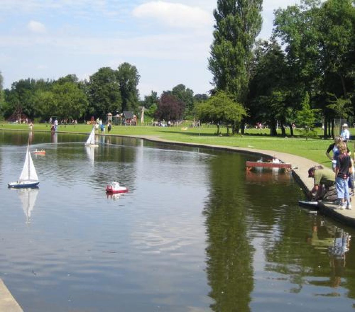
The layout of Rowntree Park is characterised by a formal garden area in the centre on a strong east/west axis, with a lawn to its north and to its south, the site of a former bandstand. Parallel to the western boundary lies a long serpentine lake, created by the diversion of Clementhorpe Beck.
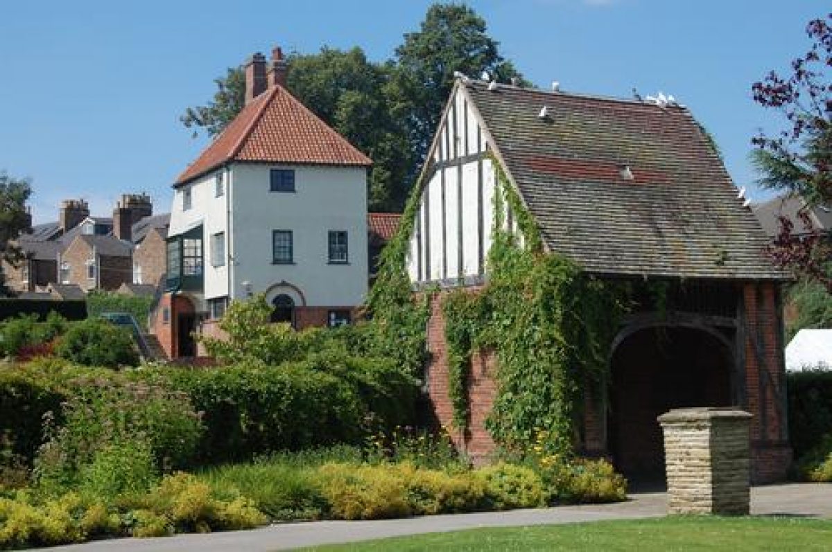
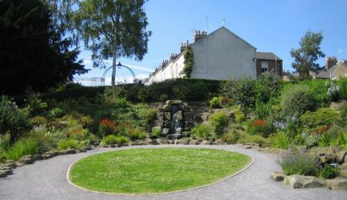
The steps at the Richardson Street entrance to the west of the park lead down into a horseshoe-shaped rockery with a cascade set into the hillside (restored c 2002). The rockery and cascade were laid out in c 1935 and replaced an early C20 flower bed. Adjacent, to the north of the rockery, stands the tea room, built in 1921 (restored c 2002). Immediately to the south of the entrance and rockery is a teardrop-shaped rose bed, formerly a small lily pond. The layout of the Richardson Street entrance is shown on a sketch plan of c 1921.
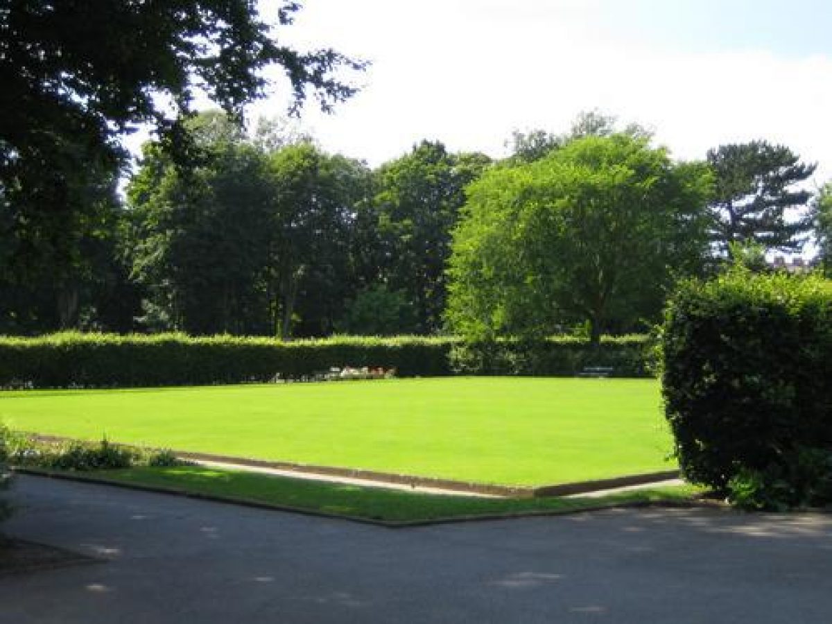
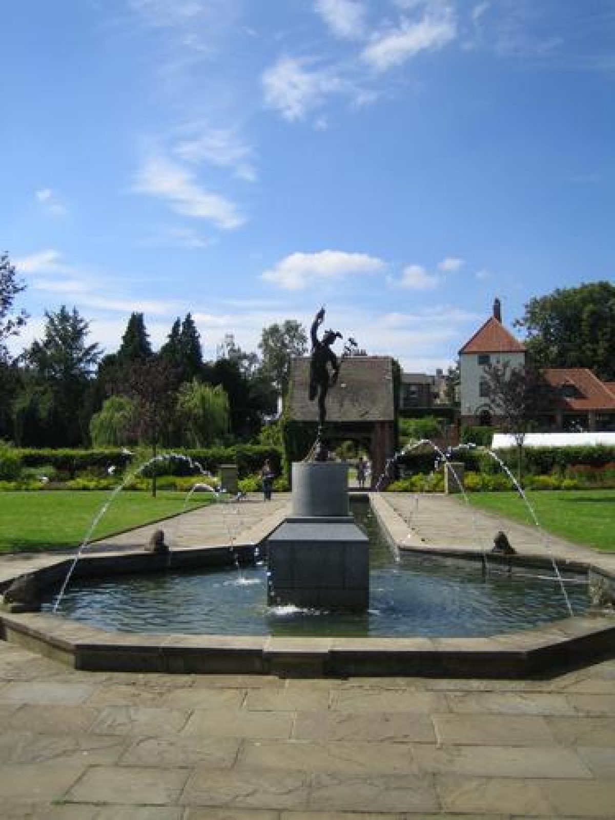
To the south-east of the tea room, a hump-backed bridge with brick parapets leads over the long serpentine lake to a lych-gate with a dovecot constructed in red brick with mock timber framing. Inside the lych-gate are two bronze plaques commemorating those members of the York Cocoa Works staff who fell and suffered during both world wars. On passing through the lych-gate, there is a view of the narrow canal which leads into a hexagonal pond. This water feature had been filled in and planted with grass and bedding plants but has now been restored (c 2002). As shown on contemporary photographs, a statue of Mercury stood in the centre of the pond (modern replacement erected c 2002). The canal and pond were laid out post 1929 and occupy the site of the former bandstand. The latter was removed from this position in 1929 and was replaced by a new bandstand at the south end of the park. Further to the east, the central axis with the canal is flanked by flower beds and hedges on either side of the central path. The central path, forming the east/west axis, is flanked on either side by lawns with flower beds and bowling greens. Both lawns with flower beds were formerly laid out with parterres surrounded by a hedge, all removed in the 1950s. These formal gardens are screened from the rest of the park by tall beech hedges.
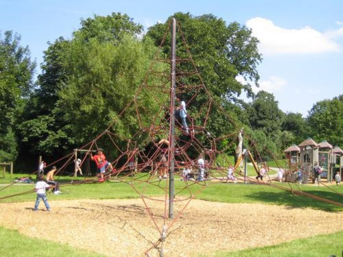
The north and south parts of the park are characterised by an informal layout with a network of paths leading from the central area of the park. A number of large modern sculptures have been placed at various points around the park. The area to the north is laid out as a lawn bounded to the north and east by a thick belt of trees. In the centre was formerly a small wading pool with a sun shelter and on the east side a swimming bath; all were removed by the late C20. The northern end of the park is now occupied by a variety of children's play equipment, the area surrounded by hoop-topped metal railings c 1m high. In the far north-east corner is a car park which covers the site of a former bowling green, later converted to a putting green.
The south part of the park is divided by the southern arm of the serpentine lake into two areas: the site of the former bandstand to the east, and the area of the pergola to the west. The site of the bandstand stands in an open circular space, surrounded by a thick belt of trees. The bandstand was built in 1929 and demolished in the late C20. The site is now occupied by a low elliptical-shaped plinth c 15m across edged by a limestone wall to the front (south) and by a similar wall which stands c 0.8m high above the platform to the north-west. This is used for public events in the park. The pergola, which occupied the former Clementhorpe allotments, was removed in the 1950s, leaving only the footprint but it has now (c 2002) been restored. It consists of a north to south section covering the principal path, with a semicircular section at the north end which bounds a circular area with decorative brick paving. To its north are two tennis courts, and the remains of a former aviary, built in 1930 and removed in the 1950s.
The eastern edge of the park is occupied by a series of recreational facilities. Immediately to the north of the bandstand area is a tennis court enclosure with a modern pavilion building to the east. To the north of the pavilion is a small kiosk with shed attached (now disused). Beyond this, to the south of the entrance gates on Terry Avenue, a large fenced enclosure (formerly tennis courts) has been converted to a skate park. A similar enclosure to the north of the gates is a basketball court. A toilet block is situated at the south-east corner of the north lawn. In the north-east corner of the park, a large maintenance compound surrounded by brick and roughcast walls c 3m high adjoins the car park.
Maps
- Sketch plan of Rowntree Park, nd (191 Ph278/5180), (York City Archives)
- Sketch Plan and Suggested Layout for a Recreation Ground for the City of York, 1919 (191 Ph278/5180), (York City Archives)
- Plan of Clementhorpe Park showing proposed site of swimming pool, 6 October 1921 (191 Ph247/4562), (York City Archives)
- City of York, Clementhorpe Park Proposed Entrance Footpath, 1:500, nd, City Engineer, York (191 Ph310/581), (York City Archives)
- OS 25" to 1 mile:
- 2nd edition published 1909
- 3rd edition published 1931
- 1947 edition
- 1965 edition
Illustrations
- Aerial view of the City of York, 1936, 1.25 inches to 1 mile (Aerofilms Ltd, ref no 17476), (York City Archives)
- Various black and white photographs, 1930s (York City Archives)
Archival items
- Papers relating to Rowntree Park 1919-20 (RoCo93/vi8a), (Joseph Rowntree Trust Archive)
- York City Council Park Committee Minutes (1919-74), (York City Council)
Description written: September 1999
Amended: November 1999
Revised (CAA): October 2004
Register Inspector: FDM
Edited: October 2004
- Visitor Access, Directions & Contacts
Access contact details
This is a municipal site, open daily from 8 am and dusk.
Owners
York City Council
Library Square, York, YO1 7DU
- History
The following is from the Register of Parks and Gardens of Special Historic Interest. For the most up-to-date Register entry, please visit The National Heritage List for England (NHLE):
20th Century
In 1919 Messrs Rowntree & Co bought 17 acres (c 7ha) of land from the Ecclesiastical Commissioners in order to create a public park and recreation ground. This was the meadow land of Nun Ings which lay between Clementhorpe Beck and the tow path beside the River Ouse. Subsequently in 1919-21, a small additional piece of land was bought by the Company to provide land for the entrance from Richardson Street. Later, in 1926-7, a further area was added on the south-west edge of the park, formerly the Clementhorpe allotments.
On 16 July 1921 the opening ceremony of the park took place, and it was presented to the City of York as a memorial to the members of the York Cocoa Works staff who fell and suffered during the First World War. In the same year the Cocoa Works Magazine reported that the park was created by the Rowntree Village Trust in consultation with the architect Frederick Rowntree (1860-1927), assisted by W J Swain, architect of the York Cocoa Works, and Mr P W Woods, the head gardener at the Cocoa Works. The sketch plan for Rowntree Park of c 1919 has been attributed to Frederick Rowntree (Heritage Report for Rowntree Park, 1996). The trees and shrubs for the park were supplied by the James Backhouse Nurseries in York. Grass seed came from Suttons and roses from the Scarborough firm of Messrs Walker & Son.
21st Century
Rowntree Park is now (2004) managed by the City of York Council Leisure Services. In 1996 they obtained funding for the repair, restoration, and extension of the park through the Heritage Lottery Fund and these works are now complete.
Period
- 20th Century (1901 to 2000)
- Early 20th Century (1901 to 1932)
- Associated People
- Features & Designations
Designations
The National Heritage List for England: Register of Parks and Gardens
- Reference: GD2903
- Grade: II
Green Flag Award
Features
- Lake
- Dovecote
- Pavilion
- Bowling Green
- Gate
- Description: The entrance gates at Terry Avenue were donated to the park as a memorial to the fallen of World War 2. They are made of wrought iron and originally date to 1715.
- Earliest Date:
- Latest Date:
- Railings
- Description: The boundaries are formed principally of metal railings.
- River
- Description: River Ouse.
- Parkland
- Meadow
- Walk
- Key Information
Type
Park
Purpose
Commemorative
Principal Building
Parks, Gardens And Urban Spaces
Period
20th Century (1901 to 2000)
Survival
Extant
Hectares
8.5
Open to the public
Yes
- References
References
- {English Heritage Register of Parks and Gardens of Special Historic Interest}, (Swindon: English Heritage, 2008) [on CD-ROM] Historic England Register of Parks and Gardens of Special Historic Interest
- LDA Design {Rowntree Park: Heritage Report} (1996) Rowntree Park: Heritage Report
- p 88 [Obituary of Frederick Rowntree] The Builder, 132