Introduction
The museum gardens, originally designed as the pleasure grounds for the mid-19th-century Yorkshire Museum, also provide the setting for a number of Ancient Monuments including the ruins of St Mary's Abbey. The current layout dates back to Sir John Nasmyth's design of around 1844. The gardens have been open to the public since 1961 and are a listed botanical garden.
Terrain
The site slopes down south-westwards to the banks of the river.
The following is from the Register of Parks and Gardens of Special Historic Interest. For the most up-to-date Register entry, please visit The National Heritage List for England (NHLE):
Location, Area, Boundaries, Landform and Setting
The Museum Gardens lie on the north bank of the River Ouse in York, c 300 m south-west of York Minster in an urban area. The c 3.74 ha site is on land which slopes down south-westwards to the banks of the river. Museum Street forms the eastern boundary, along which there is a stretch of city wall (medieval, listed grade I) and on the south side a cast-iron fence (1844, listed grade II) divides the Gardens from a walkway called the Esplanade alongside the River Ouse. An area in the south-west corner of the Gardens, formerly the site of a swimming pool, is not included in the registered area. On the west side of the site the boundary is formed by the crenellated wall of the Abbey precinct (C13, C14, listed grade I), the Gatehall (C12, listed grade I) with its entrance arch, and St Mary's Lodge (C14, listed grade I), which are ranged along the western edge of the site on Marygate. St Olave's church (listed grade I) and churchyard are not included in the registered area.
Entrances and Approaches
The principal entrance is from Museum Street where there are gates and a lodge (listed grade II) attached to the medieval city wall. The lodge was built in 1874-5 to designs by Fowler Jones on land acquired in 1845. It is in use as offices for the Yorkshire Philosophical Society (1999). This entrance replaced a Greek Revival-style lodge which lay c 30m north-west of the present building, and was demolished in 1849. The land acquired in 1845 included a vaulted tunnel (C13, listed grade I) leading to St Leonard's Hospital. An entrance on the west side of the site from Marygate is formed by the Gatehall which is the remains of the main gate to the Abbey precinct, and is linked to an Abbey guesthouse called St Mary's Lodge. This part of the site was acquired by the Yorkshire Philosophical Society in 1850. Other entrances to the site include gates from the riverside walk and a narrow alley called Manor Lane on the north-east side of the site with a gated entrance beside Manor Cottage (listed grade II), which was built as a curator's house in 1844.
Principal Building
The Yorkshire Museum (listed grade I) lies on the north side of the site. It was designed in 1827 by William Wilkins in Greek Revival style and has a pedimented portico on the south elevation. The basement of the building incorporates the ruinous remains of St Mary's Abbey dating from the C12, C13 and C14. The Tempest Anderson Hall, designed by E R Tate, was added to the west side of the Museum in 1912. The building remains in use as a museum (1999).
Gardens and Pleasure Grounds
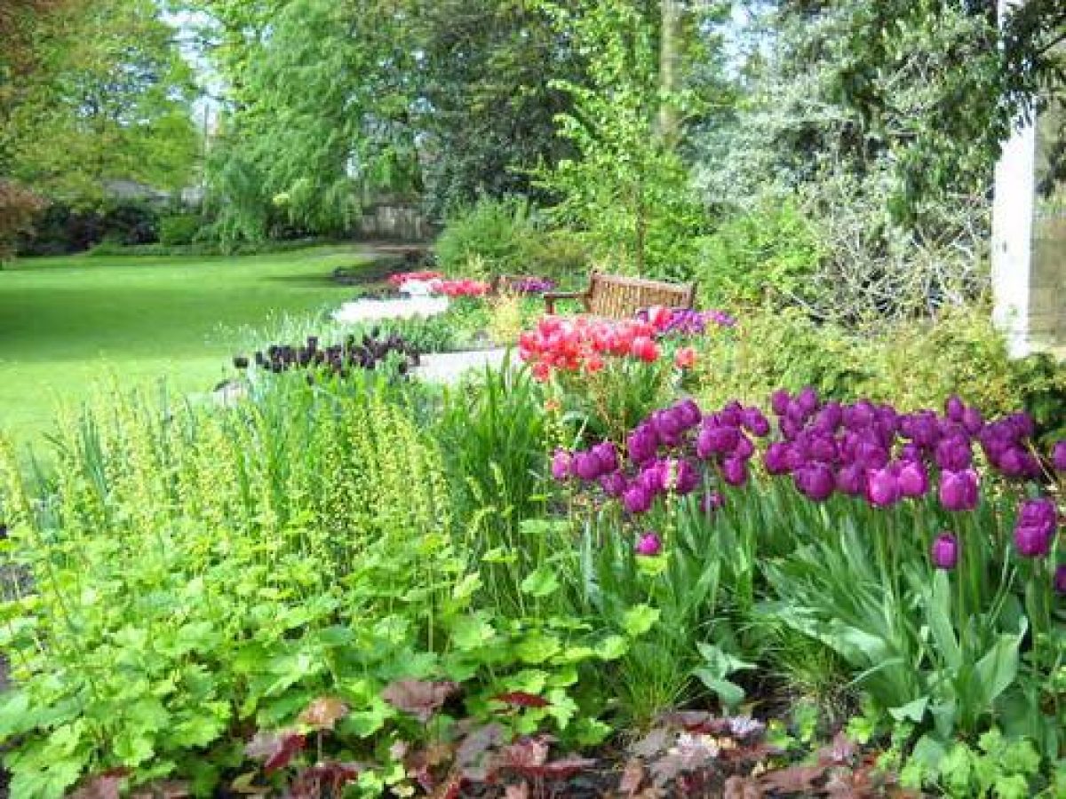
A forecourt, supported by a stone retaining wall with parapets, fronts the Museum and there are views to the south and south-west over the Gardens and to the river, with views of a building called the Hospitium (listed grade I) between clumps of trees and shrubs. The arcaded remains of the nave of the former St Mary's Abbey (listed grade I) can be seen to the west. On the west side of the forecourt steps lead down to a circuit path which runs alongside the Abbey ruins. This joins with a path from the west entrance at a point where there are rock gardens of 1981, c 70 m south-west of the Museum, and continues, with the route lined with fragments of medieval masonry, south to the Hospitium c 120 m south-west of the Museum. This structure probably dates from the C14 and C15, and was probably an Abbey guesthouse. The building was restored between 1838 and 1848 and a new roof added in the 1930s.
A bank along the south side of the site was created as a late C20 flood defence, and a serpentine path runs through a shrubbery between the bank and fenced site boundary. The OS map published in 1852 shows a band of planting along the boundary which had gaps in it giving views of the river from the Gardens and allowing glimpses of the grounds from the Esplanade. These views have largely been lost. The bank runs over an area immediately south of the Hospitium which was the site of the Order Beds, a botanic garden with a geometrical layout shown in Durrant's plan of 1847 which was grassed over in the mid C20.
The area immediately north of the swimming pool site in the south-west corner of the Gardens (outside the registered area) has lawns studded with mature trees. The 1847 plan shows that this was an enclosed garden belonging to St Mary's Lodge which was absorbed into the site in the 1880s.
The main circuit path leads eastwards from the Hospitium and joins a route called Old Cross Path which runs across lawns from the junction of the circuit path and a route from the west entrance. The circuit path then curves north-eastwards up the slope to join with the path from the main entrance, which runs north-west to the Museum forecourt, completing the circuit. This route is substantially as shown on the 1847 plan, though some realignment had taken place on the east side of the site by 1852 (OS), possibly in response to the acquisition of additional land near the main entrance. The walk was carefully designed to offer changing views of the grounds, buildings and antiquities.
In the south-east corner of the site, in an area screened by a band of trees and shrubs, there is a lawn and a series of stone terraces, c 100 m south-east of the Museum, which was the site of a glasshouse shown on the 1847 plan and demolished in the mid C20. Another glasshouse to the south is shown on the 1892 OS map; this was demolished in the 1960s. Immediately to the south and east there is a C20 toilet block in an area shown on the 1847 plan as planting beds associated with the glasshouse. A maintenance yard, which includes a tunnel running beneath the city wall, lies in the extreme south-east corner of the site in an area shown in use for this purpose on the 1847 plan.
A path laid out in 1981 branches south-west from the main approach to the Museum and leads past the Observatory (Thomas Cooke 1832-3, listed grade II), which lies c 60 m south of the Museum within a clump of shrubs close to the centre of the site. The path continues westwards and joins with the Old Cross Path. The Observatory is an octagonal, single-storey building with a rotating conical roof designed by John Smeaton. It was built following the inaugural meeting of the British Association for the Advancement of Science and at that time it contained the largest refracting telescope in the world. The building was restored in 1981.
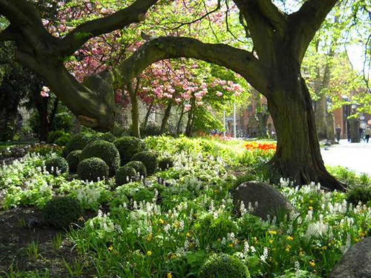
The centre of the site has sloping lawns planted with specimen trees and clumps of shrubs and trees. The planting around the Observatory and a clump to the east of the Hospitium are in the positions of clumps shown on the 1847 plan. The planting of the central lawn serves to control views of the various buildings and ruins as the paths around the grounds are followed, though the maturity of some of the trees and areas of new planting have obscured some of the vistas.
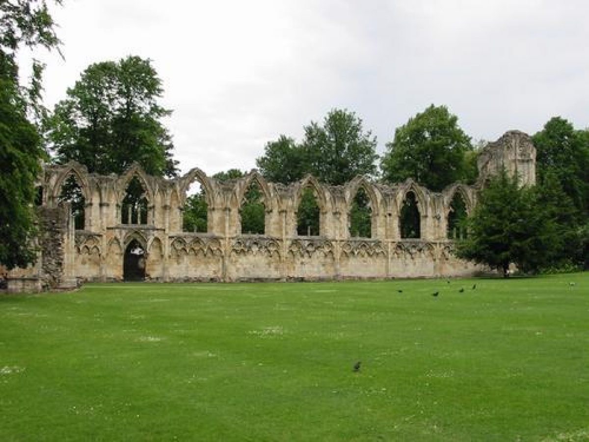
The north-west corner of the site is dominated by the ruins of the north transept and choir of the church of St Mary's Abbey. A bank between the Abbey ruins and a bowling green, shown on the 1909 OS map, supplies a vantage point for viewing the remains and it may have been formed from spoil from excavations undertaken by the Yorkshire Philosophical Society in the early C20.
On the east side of the Museum there is a lawn divided by the path from Manor Walk which is overlooked by the Multangular Tower (Roman with medieval upper levels, listed grade I) c 30 m to the south-east. The city wall (medieval, listed grade I) attached to the north side has an opening in it leading to the lawns south of York's Central Library. The east side of the Multangular Tower is attached to a stretch of Roman wall which runs south-east along the top of a bank towards Museum Street.
Maps
[reproduced in Goodchild 1996]
- W Durrant, Plan of the Property of the Yorkshire Philosophical Society, 1847
- OS 25" to 1 mile: 1st edition surveyed 1889, published 1892; 2nd edition published 1909
- OS 5' to 1 mile: 1st edition surveyed 1851, published 1852
- Additional information supplied by City of York Council and the Yorkshire Philosophical Society.
Description written: December 1998
Amended: December 1999
Edited: April 2000
- Visitor Access, Directions & Contacts
Access contact details
The main gardens will be open from 9am to 6pm.
The Artists’ garden will be open from 10:30am to 4:30pm.For more detailed visitor information visit the Yorkshire Museum Gardens website.
Owners
The Yorkshire Museum and Gardens Trust
- History
The following is from the Register of Parks and Gardens of Special Historic Interest. For the most up-to-date Register entry, please visit The National Heritage List for England (NHLE):
11th Century
The Museum Gardens lie immediately west and south-west of the south-west tip of the late 2nd-century Roman legionary fortress of Eboracum and incorporate the western angle tower, called the Multangular Tower, of the Roman fortress wall. The site is within the precinct of St Mary's Abbey, founded when Benedictine monks were granted the church of St Olave in 1086. A new abbey was built on land adjacent to the church in the years which followed.
16th Century
The Abbey was dissolved in 1539 but substantial remains survived.
19th Century
In 1827, the Yorkshire Philosophical Society acquired part of the Abbey site and other land amounting to 1.2 hectares from Lord Grantham (who leased it from the Crown) as part of the site for their new museum. One of the conditions of sale was that scientific gardens should be established. In the years which followed more land was bought as part of a policy of acquiring and protecting antiquities. The grounds were levelled and planted with a hardy herbaceous perennial collection during the 1820s to 1840s. In order to bring a unified approach to the haphazard layout Sir John Murray Nasmyth (1803-76) of Dawyck, Peeblesshire, was asked to draw up a scheme for the gardens in 1844. His brief asked him to 'surmount the peculiar difficulties presented by the site so as to produce the most pleasing effects by the harmony or contrast of its varied architectural features ... to open out the interesting views of more distant objects, while excluding as much as possible of such as are unsightly or incongruous' (quoted in Goodchild 1996, 11). His design therefore provided private pleasure grounds for members of the Society which formed an appropriate setting for the Museum and the various ancient monuments, and incorporated a botanical garden.
The executed scheme is shown on a plan by Durrant dated 1847 (reproduced in Goodchild 1996). The Gardens were exclusively for the use of members of the Society and were only opened to the public on occasional days.
20th - 21st Century
In 1961 the Society gave the Museum and gardens in trust to the citizens of York. The gardens are owned and managed by the Yorkshire Museum and Gardens Trust which has trustees drawn from the City of York Council and the Yorkshire Philosophical Society.
The grounds are open to the public (2023).
Period
- Post Medieval (1540 to 1901)
- Victorian (1837-1901)
- Associated People
- Features & Designations
Designations
The National Heritage List for England: Register of Parks and Gardens
- Reference: GD1012
- Grade: II
Features
- Museum (featured building)
- Description: The building was opened by the Yorkshire Philosophical Society, and was one of the first purpose-built museums in the country.
- Earliest Date:
- Latest Date:
- Boundary Wall
- Description: A stretch of the medieval city wall forms part of the eastern boundary.
- Fence
- Description: Cast-iron fence.
- Earliest Date:
- Latest Date:
- Walk
- Description: A walkway called the Esplanade alongside the River Ouse.
- Boundary Wall
- Description: On the west side of the site the boundary is formed by the crenellated wall of the Abbey precinct.
- Earliest Date:
- Latest Date:
- Gateway
- Description: The Gatehall.
- Earliest Date:
- Latest Date:
- Gate Lodge
- Description: St Mary's Lodge.
- Earliest Date:
- Latest Date:
- Garden Building
- Description: The Hospitium.
- Tower
- Description: The Multangular Tower, part of the Roman fortress.
- Earliest Date:
- Latest Date:
- Specimen Tree
- Description: Cut leaved Hornbeam (Carpinus betulus 'Incisa').
- Specimen Tree
- Description: Elaeagnus leafed pear (Pyrus elaeagnifolia)
- Specimen Tree
- Description: Pear barked beech (Fagus sylvatica 'Miltonensis')
- Specimen Tree
- Description: Willow leaved ash (Fraxinus angustifolia 'Lintiscifolia')
- Specimen Tree
- Description: Cut leaved alder (Alnus Glutinosa 'Imperialis')
- Specimen Tree
- Description: Cultivated pear (Pyrus communis 'Sativa')
- Specimen Tree
- Description: Weeping silver lime (Tilia tomentosa 'Petiolaris')
- Specimen Tree
- Description: Small leaf lime (Tilia cordata)
- Key Information
Type
Park
Purpose
Recreational/sport
Principal Building
Parks, Gardens And Urban Spaces
Period
Post Medieval (1540 to 1901)
Survival
Extant
Hectares
3.74
Open to the public
Yes
- References
References
- {English Heritage Register of Parks and Gardens of Special Historic Interest}, (Swindon: English Heritage, 2008) [on CD-ROM] Historic England Register of Parks and Gardens of Special Historic Interest
- Pevsner, N. and D. Neave, {The Buildings of England: Yorkshire, York and the East Riding} (London: Penguin, 2nd edition 1995), pp. 117-9 The Buildings of England: Yorkshire, York and the East Riding
- C Wilson C and J Burton J., (1988) St Mary's Abbey, York
- Unpublished MA dissertation, IOAAS, York, (1992) Museums with Historic Gardens in Local Authority Ownership
- HLF Urban Parks Programme 1996 Heritage Report - Museum Gardens
- Related Documents