Introduction
Ripley Castle has pleasure grounds, a landscape park to the north and east of the castle and a walled garden. The site covers approximately 130 hectares, including the estate village. The park is traditionally attributed to Capability Brown, but is possibly only based on Brownian principles.
Terrain
The site stretches over the valley of the Ripley Beck from which the land rises to the east and west.The following is from the Register of Parks and Gardens of Special Historic Interest. For the most up-to-date Register entry, please visit The National Heritage List for England (NHLE):
Gardens and pleasure grounds of the late 18th and early 19th centuries, and a park of early to mid-19th century probably with 18th-century or earlier origins. A kitchen garden with an orangery and pavilions dates from 1817-18.
Location, Area, Boundaries, Landform and Setting
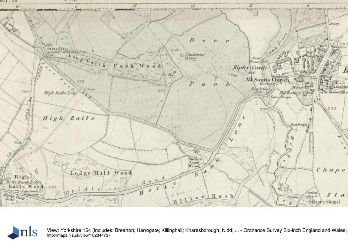
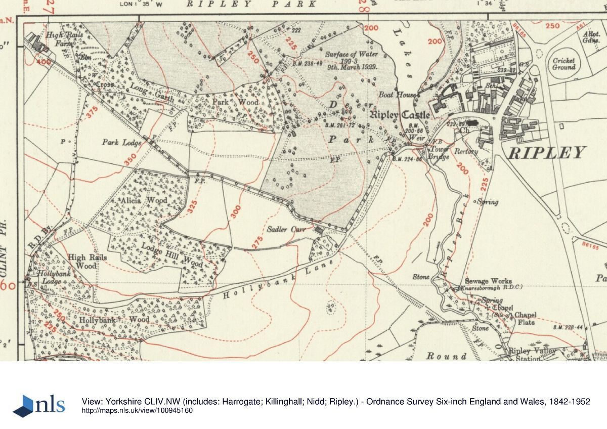
Ripley Castle lies to the north and west of the village of Ripley which was largely rebuilt in Picturesque style in the early C19 by Sir William Amcotts Ingilby. The c 130 ha site stretches over the valley of the Ripley Beck from which the land rises to the east and west. The boundaries are formed by Hollybank Lane and a track leading north-west from it to High Rails Farm on the south side, the service yard and the outer walls of the kitchen garden to the east and the B6165 to the north and east. Fences divide remaining boundaries from agricultural land to the west.
Entrances and Approaches
The principal entrance is from Hollybank Lane in Ripley where a gatehouse (C15 with C16 and C18 alterations, listed grade I) stands on the north side of the street and leads into a courtyard on the south side of the Castle. Also on Hollybank Lane an entrance c 50 m east of the gatehouse leads to the east side of the courtyard and gives access to the kitchen garden. There are a number of entrances to the park.
Principal Building
Ripley Castle (listed grade I) stands on a platform on the south-east side of the site. The earliest part of the Castle is the C15 gatehouse, replacing an earlier building, and ranges of 1783-6 were added for Sir John Ingilby by William Belwood in Gothick style. The mid C16 tower is notable for a room with original panelling of c 1555, and for the Tower Room with a fine plaster ceiling inserted in honour of a visit by James I en route to his coronation in 1603. The C18 ranges have fine classical interiors. The Castle is in use as a private residence (1998).
Service buildings (C18, listed grade II*), including stables and coach houses, are ranged around a courtyard immediately north and east of the Castle. A secondary courtyard to the north is formed by former dairy range (C18, listed grade II) on the north side with an ornamental elevation to the gardens, and a brew house and laundry block (C18, listed grade II) on the east side.
Gardens and Pleasure Grounds
A terraced walk runs around the north, west and south sides of the Castle, supported by a stone retaining wall with a crenellated parapet (listed grade II) which has projections at the terminals and corners. This was probably constructed in the 1830s. The terrace gives views to the north, west and south-west over the lakes with rising parkland beyond. Steps lead down from the south side to lawns which run down to the edge of the lower lake. At the southernmost tip of the lake there is a weir crossed by a footbridge (1843-4, both listed grade II) leading into the park. A crenellated wall runs north-eastwards from this point, dividing the grounds from Hollybank Lane, and built into it, c 70m south-west of the Castle, there is a tower (tower and wall listed grade II). The tower may have C16 origins, and the wall was probably built for Sir William Amcotts Ingilby in the early C19 when the tower was converted to an eel store.
A ha-ha (probably late C18, listed grade II) which stretches from a point c 50 m north-west of the Castle to a point c 450m to the north, runs north-east and northwards dividing the pleasure grounds from parkland. The pleasure grounds to the north are wooded and a path follows the line of the ha-ha with views to the west over the lakes and park. A path which runs northwards through the trees from the kitchen garden is aligned with a garden temple (early C19, listed grade II) which lies c 450m north-east of the Castle. This area was probably laid out by Sir William Amcotts Ingilby in the early C19, perhaps at about the time of the construction of the kitchen garden in 1817-18.
Kitchen Garden
Walled gardens lie c 150m north-east of the Castle and can be reached via a walled path leading north-east from the rear of the service yards. They consist of a large rectangular enclosure with a brick wall which runs east/west dividing the garden into two unequal parts; that to the south is narrower and is in use as a flower, vegetable and fruit garden (1998). A narrow strip at the south end of the complex is divided from the village buildings and gardens by a stone wall, and a small rectangular enclosure attached to the south-west corner of the complex is in use as a playground (1998). A central gateway in the brick dividing wall has brick piers and ball finials. This leads to a large enclosure and is aligned with an orangery against the northernmost wall of the complex which overlooks lawns and flower beds. A glasshouse runs along the north wall immediately east of the orangery, and the foundations of a matching glasshouse, shown on the 1909 OS map, survive on the west side.
The wall terminates at each end with a rectangular pavilion (orangery, walls and pavilions listed grade II*). The orangery has a range of full height arched windows divided by fluted Ionic pilasters. The parapet is crowned by a balustrade, and the roof is reached via cantilevered steps which rise on either side of a doorway on the rear (north) side of the building. The pavilions are of similar style with arched windows and balustraded parapets; that to the east was converted to a squash court, mid C20. Bothies and potting sheds are ranged along the outer north wall and the entrance to the orangery on the north side is aligned with the path leading through the wooded pleasure grounds. A gateway (listed grade II) with wrought-iron gates and tall stone piers with ball finials in the west wall leads into the western part of the pleasure grounds. The kitchen gardens, orangery and pavilions were built in 1817-18 for Sir William Amcotts Ingilby probably incorporating elements of earlier gardens on the site, and they are shown on the 1847-9 OS map.
Park
The park is pasture with many scattered trees including large mature specimens of oak and sweet chestnut. On the north side it is sheltered by woodland within which lies Broxholme, a former dower house built in the mid C19 for Sir William Amcotts Ingilby's widow and now in private ownership (1998). Park Wood lies in the southern part of the park and Long Garth, on the west side, is the site of a medieval cross base and shaft (listed grade II, scheduled ancient monument) at the edge of the park c 1km west of the Castle. A deer shelter (1852, listed grade II) lies on high ground c 450 m west of the Castle.
Two connected lakes with sinuous outlines and small islands, which were formed by damming Ripley Beck, run north-west/south-east across the eastern side of the park. They are divided by a weir of five tiers crossed by a bridge with an ornamental cast-iron balustrade (both listed grade II). There are views from the park over the lakes to the Castle. The lakes were created c 1843-4 for Sir William Amcotts Ingilby and are shown on the 1st edition OS map surveyed 1847-9. A county map of 1771 shows the park at approximately its present extent with the Ripley Beck running through it and a schematic representation of scattered trees. The maturity of the tree cover suggests the parkland has C17 or earlier origins, or that it was formed from an area of existing ancient woodland. There is a tradition that Lancelot Brown (1716-83) prepared designs for the park in the late C18 which were executed in 1843-4 (Stroud 1975) but there is no evidence in the form of plans to substantiate this theory.
Maps
- T Jefferys, County Map, 1771
- OS 6" to 1 mile: 1st edition surveyed 1847-9; 3rd edition published 1910; 1932 edition
- OS 25" to 1 mile: 2nd edition published 1909
Description written: October 1998
Amended: March 1999
Edited: October 1999
- Visitor Access, Directions & Contacts
Telephone
441423770152Website
https://www.ripleycastle.co.uk/Access contact details
The gardens are open daily from 9 am throughout the year. Opening times for the castle are more restricted.
For more detailed information visit the Ripley Castle website.
- History
The following is from the Register of Parks and Gardens of Special Historic Interest. For the most up-to-date Register entry, please visit The National Heritage List for England (NHLE):
14th to 16th Century
The Ingilby family acquired Ripley through marriage to the Thweng family in the 14th century. Sir Thomas Ingilby consolidated the estate through purchases and enclosures during the late 14th and early 15th centuries. The Ingilbys were a prominent recusant family during the 16th century and took the Royalist side in the Civil War.
17th and 18th Century
The estate remained intact despite changing political fortunes, the imposition of crippling fines during the 17th century and the exile of Sir John Ingilby for his support of James II in 1688. Another period of exile followed when Sir John's grandson, also Sir John, was forced to flee to the continent to escape his creditors in 1794, following the refusal of his father-in-law, Sir Wharton Amcotts, to make a settlement upon his daughter who had married Sir John in 1780.
19th and 20th Century
The estate was left in the care of manager John Hewitt, whose careful stewardship facilitated the repayment of debts, allowing Sir John to return in 1804. He was succeeded by Sir William Amcotts Ingilby in 1815 who had inherited substantial estates from the Amcotts family allowing him to undertake large-scale improvements at Ripley. The estate has been in the unbroken ownership of the Ingilby family for twenty-seven generations and remains in private ownership (1998).
- Associated People
- Features & Designations
Designations
The National Heritage List for England: Register of Parks and Gardens
- Reference: GD1365
- Grade: II
Features
- Kitchen Garden
- Description: Walled kitchen garden.
- Earliest Date:
- Latest Date:
- Herbaceous Border
- Orangery
- Description: listed grade II* built in 1817-18 for Sir William Amcotts Ingilby
- Earliest Date:
- Latest Date:
- Pavilion
- Description: listed grade II* built in 1817-18 for Sir William Amcotts Ingilby
- Earliest Date:
- Latest Date:
- Palm House
- Ha-ha
- Key Information
Type
Estate
Purpose
Ornamental
Principal Building
Heritage Site
Survival
Extant
Hectares
130
Open to the public
Yes
Civil Parish
Ripley
- References
References
- {English Heritage Register of Parks and Gardens of Special Historic Interest}, (Swindon: English Heritage, 2008) [on CD-ROM] Historic England Register of Parks and Gardens of Special Historic Interest
- Stroud, D., {Capability Brown} (London: Faber, 1975), p. 238 Capability Brown
- Pevsner, N., {The Buildings of England: Yorkshire The West Riding} (Harmondsworth: Penguin Books, 2nd edition 1967), p. 401 The Buildings of England: Yorkshire The West Riding
- Sir Thomas Ingilby, around 1995 Ripley Castle, guidebook