Introduction
Ragley Hall is situated within an 18th-century landscape park by Lancelot Brown, covering about 340 hectares. Late-19th-century formal gardens by Robert Marnock lie adjacent to the Hall. Features include formal gardens, a rose garden and a woodland walk.
Terrain
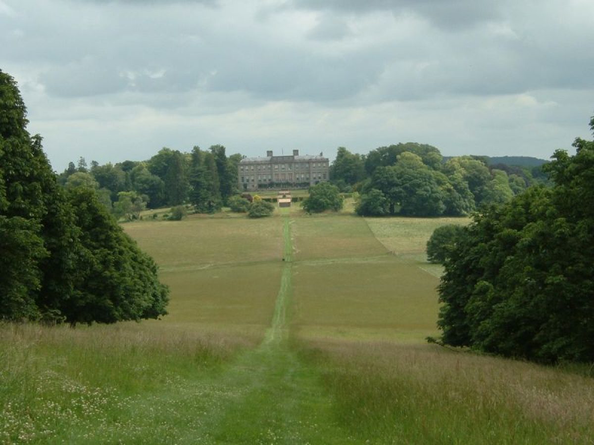
Ragley Hall stands on an eminence towards the centre of the site, with the ground dropping away on all sides. The park rises to ridges of high ground to the north-east, west and south.www.historicengland.org.uk/listing/the-list
Summary of GardenA mid-C18 park landscaped by Lancelot Brown, with late-C19 formal gardens and pleasure grounds laid out by Robert Marnock; with a small detached area under Oversley Castle, c 2.5km to the east, an eyecatcher to Ragley Hall.
Details
A mid-C18 park landscaped by Lancelot Brown, with late C19 formal gardens and pleasure grounds laid out by Robert Marnock; with a small detached area under Oversley Castle, circa 2.5km to the east, an eyecatcher to Ragley Hall.
LOCATION, AREA, BOUNDARIES, LANDFORM, SETTING
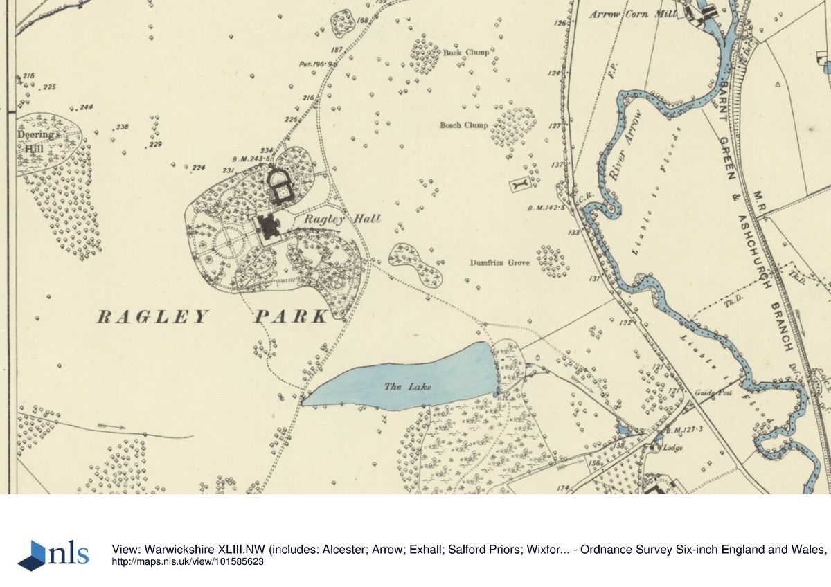
Ragley Hall is situated circa 1km south-west of the village of Arrow, and some 2km south-west of the town of Alcester, on the west side of the B4085 road which leads from Arrow to Bidford-on-Avon. The circa 340ha site comprises some 12ha of gardens and pleasure grounds, a lake of circa 4ha and circa 324ha of parkland. The site is bounded to the east by the B4085 road, and to the south-east and south by a minor road which leads from Wixford to Dunnington. To the south-west and west the site adjoins agricultural land on a ridge of high ground, while to the north-west and north the site is bounded by agricultural land. To the north-east the boundary is formed by the A422 road, Arrow Lane. The park is fenced to the east, south-east and south with a traditional timber pale. Ragley Hall stands on an eminence towards the centre of the site, with the ground dropping away on all sides. The park rises to ridges of high ground to the north-east, west and south, while there are extensive views in all directions from the Hall and pleasure grounds across the park to surrounding agricultural land. There are significant views east across agricultural land and to Oversley Castle, a late-C17 farmhouse converted in the late C18 or early C19 to a sham castle, which stands on a hilltop circa 2.5km east of the Hall. The Castle was remodelled as an Arts and Crafts house in 1932, and is today (2016) partly obscured by trees.
ENTRANCES AND APPROACHES
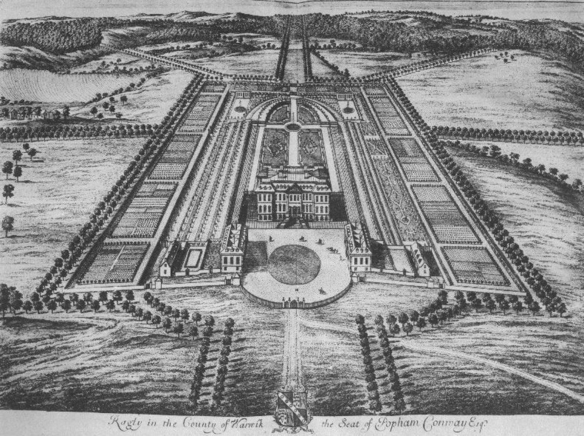
Ragley Hall is approached from the B4085 road to the north-east. Quadrant walls which terminate to north and south in piers with rusticated quoins and inset niches flank a pair of late C18, single-storey, neo-classical lodges (all listed Grade II*). Wrought-iron carriage gates with gilded spear finials are separated from similar flanking pedestrian gates by open cast-iron piers which are surmounted by lanterns (all listed Grade II*). The tarmac drive enters the park and passes through a late C20 metal gate c 20m west of the lodges, before sweeping south-west and west and climbing gently for c 450m through the park. There are views north from the drive to the walled garden and to Lord Henry's Clump and other parkland planting on high ground to the north, while the Hall is hidden from view by Buck Clump and rising ground to the south. Sweeping south-west and climbing more steeply for c 270m, there are views north-west across the park. A service drive, shown on an early C19 plan of the park (WCRO), leads c 200m south-west to the stables, while the principal drive follows a level course south-east for c 190m. A further service drive leads west-south-west for c 100m, passing through early C19 wrought-iron gates and shrubbery to reach the stables north-east of the Hall. The principal drive turns sharply south-west to approach the east facade of the Hall on its central axis. A gravelled forecourt is separated from the park to the east by a simple timber post and rail fence with pedestrian gates flanking a cattle grid. The forecourt is separated from the stables to the north by evergreen shrubbery and trees, and the gardens to the south by yew hedges. The present arrangement of the forecourt and approach aligned on the Hall, which is shown on the 1886 OS map, replaced a more informal approach from the north-north-east and a carriage turn enclosing an oval lawn which is shown on an early C19 plan of the park (WCRO). Kip's bird's-eye view of Ragley from the east (published 1707) shows a forecourt flanked to north and south by service blocks, and entered from the east by gates set in a semicircular wrought-iron screen. A double avenue is shown aligned on the east facade of the Hall, with a further track approaching from the north-east; this arrangement was modified in the mid-C18, probably as part of Lancelot Brown's improvements (Stroud 1975), and does not survive (as of 2000).
A further drive approaches the Hall from the minor road to the south. Evesham Lodge, a picturesque gabled lodge dated 1872, comprising a single storey and attic with elaborate ornamental timbering and bargeboards under a fish-scale-tiled roof (listed Grade II) stands to the west of the entrance which is situated opposite Hollybush Farm on a sharp bend in the road. Tapered wooden gate posts surmounted by ornamental metal finials support a single white-painted timber and metal ornamental gate which leads to the tarmac south drive. The drive leads c 400m north-north-east through an area of woodland and is adjoined by wide grass verges planted with groups of ornamental trees and shrubs, before crossing a cattle grid to enter the park. The drive continues north-east for circa 850m across the park, passing immediately to the west of the lake, before crossing a carriage drive circa 270m east-south-east of the Hall, which today serves as access to a yacht club situated at the north-east end of the lake. The south drive sweeps north-west for circa 130m to the east of the pleasure grounds, before joining the principal drive c 160m east of the Hall and approaching the forecourt on the central axis of the east facade. The south drive is not shown on the early-C19 plan of the park (WCRO), but was established in its present form by 1886 (OS), probably as part of Marnock's improvements for the fifth Marquess in the early 1870s (WCRO).
PRINCIPAL BUILDING
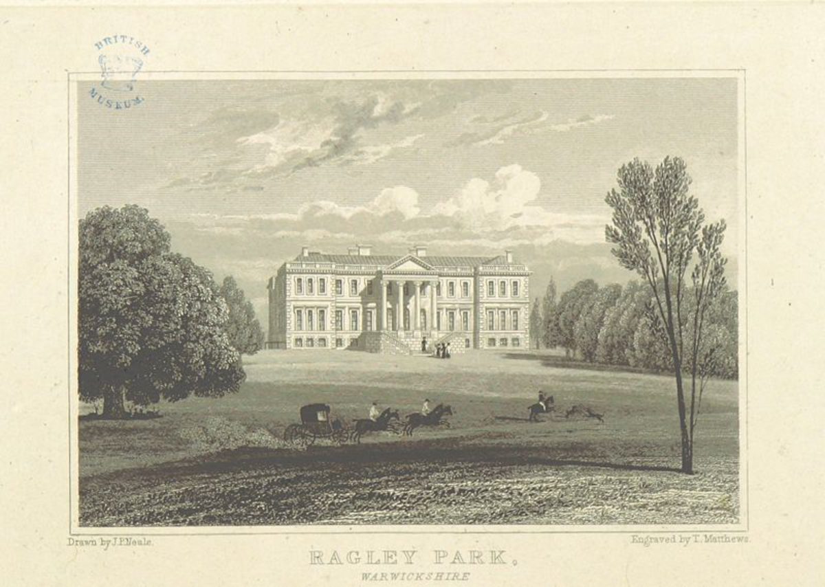
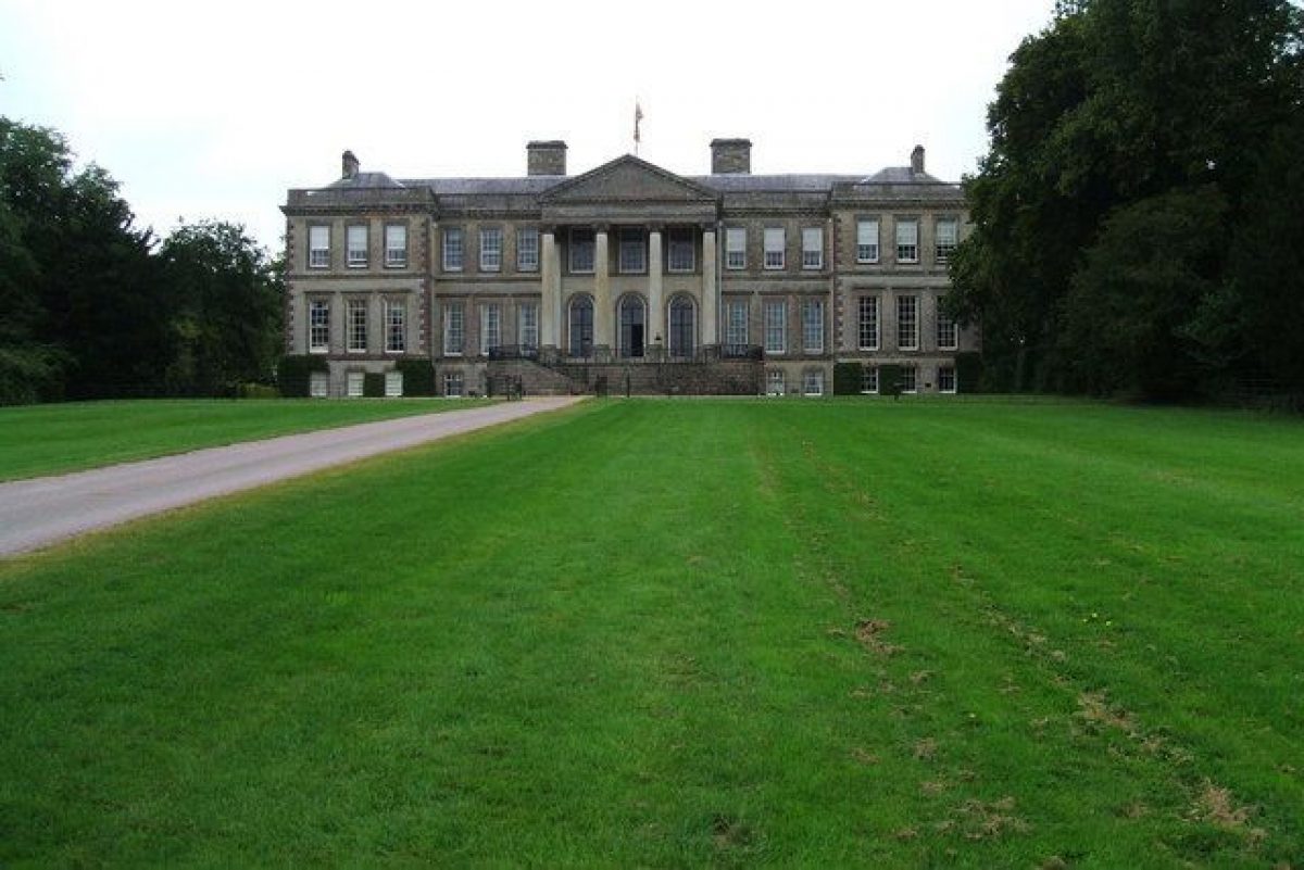
Ragley Hall (listed Grade I) stands on the levelled summit of an eminence towards the centre of the site, and replaces an earlier house to the west, elements of which survived into the mid-C18 (Tyack 1994). Designed for Lord Conway by Roger or William Hurlbut circa 1677 and modified by Robert Hooke in 1678, the mansion comprises a double-pile house with corner pavilions, each of which contained an 'apartment' or suite of rooms. The east or entrance facade is dominated by a full-height portico supported on Ionic columns which was added by James Wyatt in 1778; the entrance, which leads directly to the piano nobile, is approached from the forecourt by a double curved stone staircase with wrought-iron balustrades and lanterns. The west or garden facade has a projecting central block surmounted by an attic storey with swagged ornaments and three circular windows designed by Wyatt in 1778. A single-storey loggia supported on Tuscan columns which links the north-west and south-west pavilions was also designed by Wyatt. A double staircase linking the balustraded terrace which surmounts the loggia to the park below was removed by William Tasker circa 1870 when terraced gardens were developed west of the Hall. The recessed centre of the south facade has tall arch-headed windows on the piano nobile which light the south staircase; the north facade has a similar design. The hipped roofs rise behind a balustrade. The Hall, which remained incomplete at Lord Conway's death in 1683, was covered-in by his widow but the interior remained incomplete until 1750 when the Earl of Hertford commissioned interiors with significant rococo plasterwork.
GARDENS AND PLEASURE GROUNDS
Formal terraced gardens lie to the west of the Hall, with informal pleasure grounds to the south and an area of shrubbery and informal pleasure ground to the north.
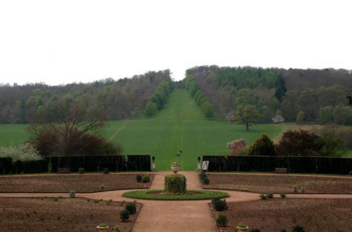
A gravelled terrace below the south facade is retained by a rusticated buttressed stone wall which returns below the west facade to retain a rectangular lawn. The lawn is enclosed to the north by a beech hedge. A flight of stone steps aligned on the centre of the west facade descends to the second terrace which comprises two sunken square panels of lawn, each with a central circular rose bed. Early C20 photographs show more complex geometrical parterres on the sunken lawns (CL 1924). The lawns are divided by an axial gravel walk, and there is a further gravel walk to the east of the lawns. Further stone steps descend from the north and south ends of the upper terrace to the eastern gravel walk. This walk is terminated to the north by a stone panel carved with a coronet and the date 1873. A narrow stone-kerbed border extends below the retaining wall of the upper terrace and is planted with roses and ornamental shrubs. The second terrace is enclosed to the north and south by ornamental shrubbery; to the north a stone bird-bath on a tapered pedestal stands in a recess within the shrubbery. A further flight of stone steps placed on an axis with the west facade descends to the rose garden on the third and lowest terrace, which comprises a circular gravel walk which encloses a circular lawn divided into quarters by cruciform gravel walks. Each quarter is laid out with two outer segmental beds and one inner segmental bed, all of which are planted with roses. At the centre of the terrace a narrow circular lawn surrounds a circular rose bed. To the west, the rose garden is enclosed by quadrant yew hedges. Stone steps aligned on the west facade of the Hall descend from the rose garden to an area of informal lawns planted with C19 specimen trees and groups of ornamental shrubs; the lawns are separated from the park to the west by C19 metal estate fencing. A pair of C19 wrought-iron gates with close-placed spear-headed rails leads from the pleasure grounds to a walk which extends the central axis of the terraced gardens west through the park to a wide avenue cut through the plantation on the east-facing hillside opposite the Hall to frame a view of the skyline. The western terraced gardens were designed by Robert Marnock in 1871-2 and were constructed by local builders, Clark and Smallwood, under the supervision of William Tasker in 1873 (WCRO). The terraces replaced lawns or parkland which swept up to the Hall, and which were framed to north and south by areas of shrubbery (Aylesford Collection view; early C19 plan, WCRO). Kip's bird's-eye view shows elaborate formal parterres west of the Hall, but omits the old manor house which survived adjacent to the present mansion until the mid-C18. Marnock's terraced garden with its circular western rose garden may have been inspired by Kip's engraving which shows a semicircular feature beyond parterres west of the Hall (CL 1924).
The gravel walk to the west and below the formal terraced gardens leads south-east to an area of late C19 pleasure grounds to the south of the Hall. The southern axial walk in the rose garden also leads to the pleasure grounds, the transition from formal to informal walk being marked by a C19 wire and wrought-iron rose arbour circa 50m south of the centre of the rose garden. The pleasure grounds, situated on a south- and south-east-facing slope below the Hall, comprise two unequal areas of informal, curvilinear walks through areas of trees and ornamental shrubbery arranged to the east and west of an open glade aligned on the south facade of the Hall. A formal walk parallel to the south terrace allows views down the sloping lawn towards the park, lake and Ladies Wood. The walk connecting with the western end of the terraced garden crosses this vista circa 100m south of the Hall. Below the walk a tennis lawn is terraced into the south-facing slope, while beyond a grass slope descends to a lawn laid out with four circular rose beds. To east and west the lawn is planted with mature standard apple trees, while it is separated from the park to the south by C19 metal estate fencing. The larger area of pleasure grounds to the east of the south vista is similarly laid out. A glade or lawn slopes south-east away from the Hall, while c 160m south-east of the Hall the walks lead to a circular garden enclosed by a mixed yew and conifer hedge. The garden is laid out with cruciform gravel walks which separate four quadrant lawns, each with a single quadrant herbaceous border. A central circular lawn surrounds a mid-C20 fountain basin. Some 200m south-east of the Hall, and adjacent to a C19 ornamental wrought-iron gate leading to the park, a late-C20 stumpery flanks a gravel walk which follows the boundary of the pleasure grounds and ascends to the Hall through an area of mature trees and evergreen shrubbery. The pleasure grounds to the south of the Hall were formed in the late C19 as part of the scheme produced for the fifth Marquess by Robert Marnock (WCRO). The pleasure grounds are shown in their present form on the OS map of 1886, although some walks have been realigned in the mid- and late C20.
The north- and north-west-facing slope below the Hall is laid out as a further area of pleasure ground, separated from the park to the north by C19 metal estate fencing. A gravel walk leads north from the western end of the terraced garden, sweeping north-east to enter an area of mature trees and evergreen shrubbery. Some 30m north-east of the Hall, the stables (listed Grade II*) stand within the pleasure grounds. The stables comprise two courts: that to the south, the Laundry Court, designed in the mid-C18 by James Gibbs includes a single-storey loggia to the south and a central circular lawn and flower bed enclosed by a gravel walk. That to the north, designed in the late C18 by James Wyatt, is D-shaped on plan with arched carriage doors in the north and east facades. The north door frames significant views across the park. Immediately north-east of the north stable court an C18 brick-lined icehouse (listed Grade II) stands among evergreen shrubs, while a C19 (restored late C20) pyramid-roofed game larder adjoins the east drive leading to the north stable court.
PARK
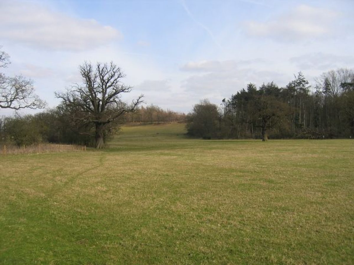
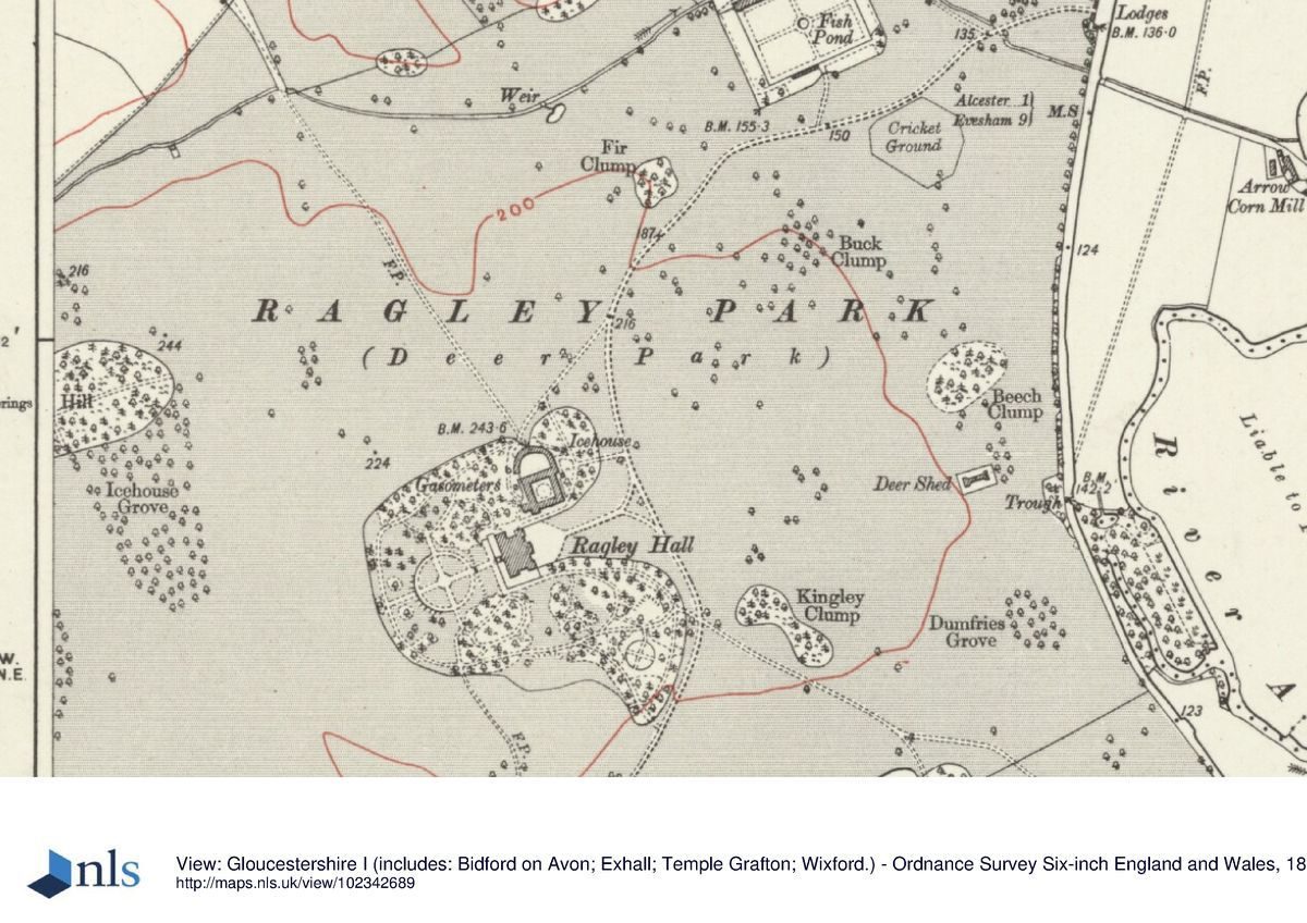
The park occupies undulating ground on all sides of Ragley Hall, and as of 2000, remains predominantly pasture with significant areas of woodland and mixed plantations to the north-east, west, south-west and south of the Hall. To the east of the Hall an area of gently sloping pasture with scattered deciduous trees extends c 600m east from the Hall, before falling sharply to the eastern boundary of the park. To the north-east Buck Clump extends along the crest of the north- and east-facing escarpment, with Beech Clump lying on the east-facing slope c 670m east of the Hall. To the south-east of the Hall a mixed plantation, Kingley Clump, contains late C20 children's play facilities. A C20 cricket field with a timber pavilion occupies level ground south of the north drive, c 670m north-east of the Hall. Ornamental planting in the north park includes scattered trees to the north and south of the north drive, Lord Henry's Clump, a plantation of oaks on high ground c 1km north-east of the Hall and a mixed plantation including mature cedars circa 700m north of the Hall. In a valley on the north-west boundary of the park circa 800m north-west of the Hall, a small stream is dammed to form a rectangular decoy pool, to the east of which stands Park Cottage, a late-C19, two-storey ornamentally timbered keeper's house. On sloping ground to the north-west of the Hall Icehouse Grove and Deering Hill are mixed plantations which have been largely replanted in the mid- and late C20, while a substantial area of woodland on the east-facing slope facing the west facade of the Hall, Pearson's Wood, is a similar mixed plantation. A wide grass glade planted with an avenue of horse chestnuts extends c 200m up the east-facing slope into Pearson's Wood, extending the central axis of the formal terraced gardens to the skyline. This glade was re-cut by Lord and Lady Hertford in the mid-C20 (Barker 1983) following the line of a glade shown on the late-C19 OS map, which itself reflects the line of a formal avenue shown on Kip's early C18 view. The south-west or deer park is characterised by scattered groups of deciduous trees, and larger mixed plantations including Cockerham's Wood and Big Grove. The woodland in the south-west park extends to the east of the south drive to form Ladies Wood. A carriage drive, today a track, extends east from the south drive at a point c 200m north of the Evesham Lodge, passing through Ladies Wood, across the dam of the lake and back to the pleasure grounds south-east of the Hall. Some 700m north-east of the Evesham Lodge a vista is cut from the carriage drive through Ladies Wood to the lake and across the park to the south facade of the Hall, while c 730m south-east of the Hall the carriage drive passes a dogs' cemetery with a C19 monument. The lake c 400m south-east of the Hall is roughly triangular on plan with a dam at its eastern end. The carriage drive returns towards the Hall across the dam, the east-facing slope of which is planted with mature beech and evergreen shrubs. There is a mid- and late-C20 yacht club and associated clubhouse and pavilion at the north-east corner of the lake, while a late-C19 brick shed c 80m below the dam contains the remains of a pump. The lake achieved its present form in the mid-C18 when Lancelot Brown remodelled an existing lake which had been constructed in 1630 (VCH; Stroud 1975). An earth bank below the present dam may represent the dam of the earlier lake. Robert Marnock advised the fifth Marquess on planting around the lake in the late C19 (WCRO). The parkland to the north of the lake and to the south of the pleasure grounds is relatively level with scattered deciduous trees while the carriage drive extending north-west towards the pleasure grounds is planted with a mid-C20 avenue of cedars.
Robert Burdet was licensed to impark land in the parish of Arrow in 1333 (VCH), but this appears to have been outside the park at Ragley, which probably originated in the C17 after Sir John Conway acquired the property. Kip's early-C18 view shows the Hall surrounded by parkland with formal avenues extending north, south and east. To the west three avenues formed a patte d'oie beyond the formal gardens, while woodland on higher ground to the west of the Hall reflects the disposition of woodland which remains today. Brown was commissioned by the first Earl of Hertford to improve the park in the mid-1750s. Horace Walpole noted his presence, commenting in 1757 that 'Browne has improved both the ground and the water, though not quite to perfection' (Toynbee). The early-C19 plan of the park shows woodland concentrated to the west and south of the Hall, with the remainder of the park characterised by scattered trees and clumps (WCRO). Marnock's account (1873) indicates that his advice extended to the park, and included plans for new carriage roads (WCRO). The park today corresponds closely to that recorded on the late-C19 OS map (1886).
KITCHEN GARDEN
Lying c 670m north-east of the Hall on level ground to the north of the north drive, the kitchen garden is approached by a drive which leads north-west from the north drive at a point c 130m south-west of the entrance lodges. The garden is rectangular on plan and enclosed by buttressed brick and stone coped walls c 3.5m high (listed Grade II). At the centre of the south wall a pair of brick and stone square-capped piers support a pair of elaborately ornamented wrought-iron gates with an armorial overthrow (listed Grade II). The gates terminate a vista which extends north through the garden to the late C18 Garden House (listed Grade II), a two-storey brick gardener's house which is built into the north wall of the garden. As of 2000, the garden is laid out with cruciform beech hedges which converge at a central circular fountain pool. The four quarters are laid to grass with specimen and fruit trees, while there is further late-C20 ornamental planting near the house. Lean-to brick and timber glasshouses survive against the inner face of the north wall to the east and west of the house. A level grass terrace parallel to and outside the east, south and west walls of the kitchen garden is the remains of a slip garden which was enclosed by hedges; the out-grown hedge survives to the east. A service yard to the north of the garden is now a further area of lawns and ornamental planting associated with Garden House. The kitchen garden was constructed in the mid-C18 as part of the improvements associated with Lancelot Brown (Stroud 1975). The wrought-iron gates set in the south wall are probably the relocated C17 gates from the east forecourt which were removed in the mid-C18 (CL 1924; Stroud 1975). The present internal arrangement of the garden reflects that shown on the early-C19 plan of the park (WCRO) and the 1886 OS map; the slip garden is also shown on these surveys.
DETACHED AREA AT OVERSLEY CASTLE
The registered area includes a small detached, rectangular area under Oversley Castle, of 0.037ha (374m2), c 2.5km east of Ragley Hall. Oversley Castle was remodelled from a C17 farmhouse into a sham castle in the later C18 or early C19, visible from the staterooms and forecourt at Ragley. In 1932, Oversley Castle was again remodelled and significantly extended to create a large Arts and Crafts house. Since the later C20, the view of Oversley Castle from Ragley Hall has been partially obscured by trees.
Reasons for Designation
Ragley Hall, Warwickshire, a mid-C18 park landscaped by Lancelot Brown, with late-C19 formal gardens and pleasure grounds laid out by Robert Marnock is registered at Grade II* for the following principal reasons:
* Date: a very good survival of a mid-C18 park landscape with high-quality adaptations and additions in the late C19 including a terraced garden;
* Design interest: it underwent significant improvements during the C18 and C19 by two of the country's most significant and influential landscape architects, Lancelot Brown in the mid-C18 and Robert Marnock in the late C19;
* Documentation: the history of this multi-phased landscape is particularly well documented;
* Group value: a number of highly-graded listed buildings stand within the landscape, including the principal building, Ragley Hall (listed Grade I), and a pair of neo-classical lodges (listed Grade II*).
REFERENCES
J Beeverell, Lew delices de la Grande Britagne V, (1707), p 872
L Knyff and J Kip, Britannia Illustrata I, (1707)
W Dugdale, Antiquities of Warwickshire (2nd edn 1730)
J P Neale, Views of the Seats ...IV, (1821)
P Toynbee (ed), Letters of Horace Walpole III, pp 65-6; IV, p 174
Country Life, 13 (2 May 1903), p 571; 55 (22 March 1924), pp 438-46; (29 March 1924), pp 476-82; 123 (1 May 1958), pp 938-41; (8 May 1958), pp 1006-9; no 10 (7 March 1996), pp 70-5
Victoria History of the County of Warwickshire III, (1945), pp 26-31
N Pevsner and A Wedgewood, The Buildings of England: Warwickshire (1966), pp 38-2
D Stroud, Capability Brown (1975), pp 55, 237
D Barker, One Man's Estate The Preservation of an English Inheritance (1983)
Ragley Hall, guidebook, (Ragley Hall 1993)
G Tyack, Warwickshire Country Houses (1994), pp 166-72
Maps
H Beighton, A Mapp of Warwickshire, 1" to 1 mile, surveyed 1722-5, published 1729
H Beighton, A Map of Barlichway Hundred, surveyed 1729, published 1730
W Yates and Sons, Map of Warwickshire, surveyed 1787-9, published 1793
Plan of Ragley Park, early C19 [watermark 1822] (CR114A/190), (Warwickshire County Record Office)
Robert Marnock, Plan of garden steps at Ragley Hall, c 1873 (CR114A/238/3/50), (Warwickshire County Record Office)
OS Old Series 1" to 1 mile, published 1831
OS 6" to 1 mile:
1st edition published 1886
2nd edition published 1905-6
OS 25" to 1 mile:
1st edition published 1886
2nd edition published 1905
Illustrations
J Kip, Ragley in the County of Warwick the Seat of Popham Conway Esq, published 1707
Watercolour, Ragley Hall from the south-west, c 1800 (Aylesford Collection, Birmingham Reference Library Archive)
T Radcliffe, Ragley Hall from the west, c 1830
Archival items
The Seymour Conway family papers are held at the Warwickshire County Record Office (CR114A). They include estate records, early C19 surveys and reports on conditions of the gardens (CR114A/190 and CR114A/238), and late C19 correspondence and accounts from Robert Marnock (CR114A/238/1(4).
Description written: March 2000 Amended: May 2000, September 2000
Register Inspector: JML
Edited: January 2001
- Visitor Access, Directions & Contacts
Telephone
01789 762090Website
https://www.ragley.co.ukAccess contact details
The site is open between February and October, daily in peak season but with more restricted hours at other times. Please see: http://www.ragley.co.uk/opening-times/
Directions
South of the A422, 2 miles south-west of Alcester. http://www.ragley.co.uk/getting-here/
Owners
Marquess and Marchioness of Hertford
- History
The following is from the Register of Parks and Gardens of Special Historic Interest. For the most up-to-date Register entry, please visit the The National Heritage List for England (NHLE):
www.historicengland.org.uk/listing/the-list
HistoryIn 1370 John Rous was granted a licence to crenellate his manor house at Ragley. Described by Dugdale (1730) as 'imbattled like a castle', this fortified manor passed to the Brome family, and was sold in 1591 to Sir John Conway, a former Governor of Ostend who had built up an estate in Warwickshire and Worcestershire. Sir John's son served as a soldier before becoming Secretary of State to James I and Charles I. In 1625 he was created Lord Conway, and in 1628 Viscount Conway, and acquired large estates in Wales and Ireland. The first Viscount was succeeded by his son, whose plans to rebuild Conway Castle as his principal residence were abandoned due to the Civil War. The second Viscount died in France in 1655 and was succeeded by his son, Governor of three counties of Ulster and Secretary of State to Charles II, who in the late C17 decided to rebuild the house at Ragley. The new house was designed by Roger or William Hurlbut, with improvements suggested by the scientist and amateur architect Robert Hooke in 1678 (Tyack 1994). A bird's-eye engraving published by Kip in 1707 shows formal gardens and parterres, and avenues stretching through surrounding parkland. Lord Conway died however in 1683 leaving the house incomplete, and it is likely that the gardens were also unfinished (ibid). Ragley passed to Lord Conway's second cousin, Popham Seymour. The walls of the new house were completed in accordance with Lord Conway's will, but the interior was left undecorated. Popham Seymour was killed in a duel in 1699, when Ragley passed to his brother Francis, who was created Baron Conway in 1703. Lord Conway died in 1732 and was succeeded by his son, who served as Master of the Horse and Lord Chamberlain to George III, and was created Earl of Hertford in 1750 and Marquess of Hertford in 1793, the year before his death. The Earl of Hertford completed the interior of the house and commissioned Lancelot Brown (1716-83) to improve the park in the mid C18. In 1778 James Wyatt was called in to complete rooms on the west side of the house in readiness for a visit from King George III (ibid). The second Marquess, who succeeded in 1794, and his wife, were close friends of the Prince Regent, for whom the eyecatcher known as Oversley Castle is said to have been created (guidebook).
Oversley Castle, previously referred to as Upper Oversley Lodge, Oversley (Great) Lodge, Upper Lodge Farm or other variations, appears to have been in existence by at least 1652. The house was built on the Oversley estate, which was owned by the Throckmorton family of nearby Coughton Court from 1541 to 1919. In 1782, Upper Lodge Farm was leased from the Throckmortons by Francis Seymour Conway, Lord Viscount Beauchamp, eldest son of the Earl of Hertford. The lease remained with the family until 1842, during which time it was occupied by a series of tenants. During the period of the Seymour Conway lease, the house underwent some alterations, most significantly the disguising of the farmhouse as a sham castle, creating an eyecatcher from Ragley Hall. A new curtain wall with crenellations was added to cover the gables of the farmhouse, and the tower was crenellated. Probably in the same period, though not closely dateable, a second tower, this one octagonal with a projecting cap, was added to the south-west, also crenellated. By the 1850s the first mention of the building as Oversley Castle occurs, and it became a local landmark, frequently referred to as Silvester's Castle after the tenant family which occupied it until the 1880s, by which time the Seymour Conway family's involvement in the estate had ended, the lease expiring with the death of the third Marquess of Hertford in 1842. A photograph of 1880 shows the building with its towers at either end, with the crenellated curtain wall running between them. By 1889, the condition of the tall octagonal tower was such that its demolition was under consideration. Despite a petition raised by local people, it was demolished; a postcard of 1904 shows that it had been taken down so that what remained was level with the main roof of the house. In 1932, new owner David Grieg remodelled and greatly extended Oversley Castle in an Arts and Crafts style. The work included removing the crenellated wall which hid the gabled C17 ranges (though leaving the crenellations to the tower), adding two large, flat-roofed extensions to the west and north elevations respectively, and entirely refenestrating the house, which was also rendered and painted, to unify the whole. Some window openings were altered, others blocked entirely, and all the windows were replaced. Alterations were also made to the existing roofs, in order to rationalise the roofscape and improve the consistency of the pitches.
The second Marquess of Hertford died in 1822, and Ragley was abandoned by the third and fourth Marquesses, who instead lived in Paris. Succeeding in 1870, the fifth Marquess renovated Ragley, commissioning garden plans from Robert Marnock (1800-89) in the early 1870s. The fifth Marquess died in 1884 and was succeeded by his son, the sixth Marquess (1843-1912). In 1930, under the seventh Marquess, plans were prepared by C E Bateman to reduce the house in size, and after the succession of the eighth Marquess in 1940 the estate Trustees advocated the demolition of the house. The eighth Marquess, together with the Marchioness, undertook a major programme of restoration from 1956 and Ragley Hall remains (2016) in private ownership.
Ragley Hall is one of a group of sites in Warwickshire at which Lancelot Brown advised in the mid- and late C18. These include Charlecote Park (qv), Combe Abbey (qv), Compton Verney (qv), Newnham Paddox (qv), Packington Hall (qv) and Warwick Castle (qv).
- Associated People
- Features & Designations
Designations
The National Heritage List for England: Register of Parks and Gardens
- Reference: GD2201
- Grade: II*
Features
- Lawn
- Mixed Border
- Fountain
- Sculpture
- Vase
- House (featured building)
- Description: The new house, which replaced the fortified manor, was designed by Roger or William Hurlbut, with improvements suggested by the scientist and amateur architect Robert Hooke in 1678.
- Earliest Date:
- Latest Date:
- Terrace
- Description: A series of wide, rose-covered terraces.
- Maze
- Lake
- Key Information
Type
Park
Purpose
Ornamental
Principal Building
Domestic / Residential
Survival
Extant
Hectares
340
Open to the public
Yes
Civil Parish
Alcester
- References
References
- Kip, Johannes and Knyff, Leonard {Britannia Illustrata, Vol. 1} (London: Mortier, D., 1707) Britannia Illustrata, Vol. 1
- {English Heritage Register of Parks and Gardens of Special Historic Interest}, (Swindon: English Heritage, 2008) [on CD-ROM] Historic England Register of Parks and Gardens of Special Historic Interest
- Stroud, D., {Capability Brown} (London: Faber, 1975), pp. 55, 237 Capability Brown
- Pevsner, N. and A. Wedgwood, {The Buildings of England: Warwickshire} (Harmondsworth: Penguin Books, 1966), pp. 380-2 The Buildings of England: Warwickshire
- Tyack, G., {Warwickshire Country Houses} (Chichester: Phillimore, 1994), pp. 166-72 Warwickshire Country Houses
- Saltzman, L.F. and Styles, Philip {Victoria County History: Warwick, Volume 3} (London: Oxford University Press, 1945), pp. 26-31 Victoria County History: Warwick, Volume 3