Introduction
Pittville Park is a 19th-century public park adjacent to the Pump Room. It has an extent of approximately 33 hectares. Features include lakes, sporting facilities and an aviary.
Terrain
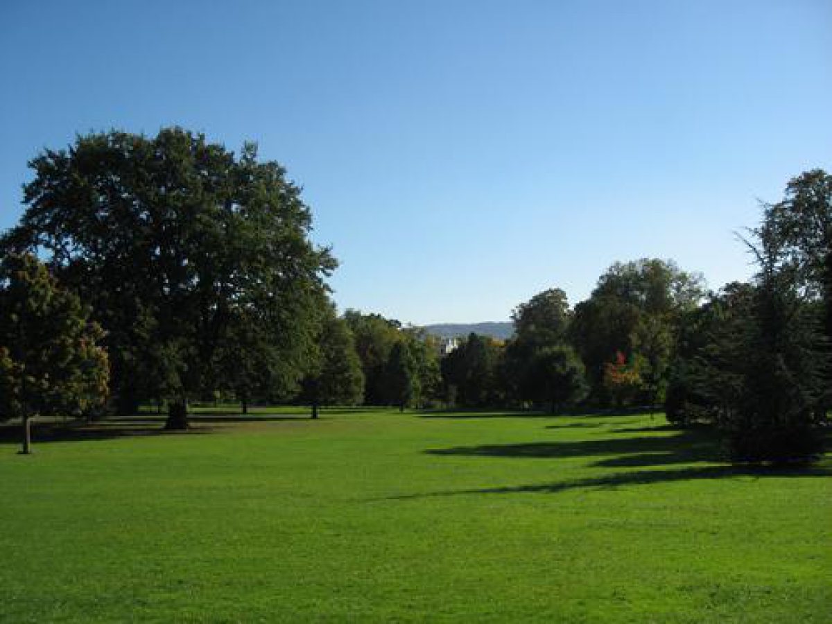
The ground slopes gently south to the lakes, then continues level to the southern boundary.www.historicengland.org.uk/listing/the-list
Pittville Gardens, designed by Richard Ware for Joseph Pitt, form the centrepiece of the Regency estate of Pittville on the outskirts of Cheltenham. The Gardens were laid out 1825-42 to provide walks for those taking the waters at Pittville Pump Room or living in the estate. The Marle Hill Annexe (the grounds of Marle Hill House) was incorporated by 1913, to form Pittville Park.
DESCRIPTION
LOCATION, AREA, BOUNDARIES, LANDFORM, SETTING
Pittville Park lies in the suburb of Pittville, to the north side of the town of Cheltenham, c 1km south of Cheltenham racecourse. The registered area is c 33ha. The park extends west to Tommy Taylor's Lane and east to Albert Road, and is divided into unequal halves by the north/south running Evesham Road. Much of the park is unfenced but wrought-iron railings extend around part of the boundary east of the lake in the eastern part and east of the recreation ground in the western part. Late C20 metal railings separate Evesham Road from both parts of the park. A low brick wall and a wooden fence (continuing north of the wall) enclose the east side of the park, between the Pump Room and the lake. Garden walls form the boundary south of the recreation ground. Presumably the whole park would have been enclosed until 1954, when entrance charges were dropped. The ground slopes gently south to the lakes, then continues level to the southern boundary.
ENTRANCES AND APPROACHES
The drive to the Pump Room enters the park between gothick gate piers (listed grade II) at the east end of the lake in the eastern half of the park and continues over a stone bridge, north to the Pump Room. The 2m high, octagonal, stone, gothick piers with peaked caps are connected to a smaller outer pair, c 1.5m high, by a low stone wall topped by wrought-iron railings. The double gates, between the larger pair of piers, are also of wrought iron, with flattened spearhead bars and dogbars. Railings probably once continued north and south from these gates, but today (1999), although the northern run still stands, no railings remain south of the gates. Other, formal, pedestrian entrances to the park are via the Eastern and Western Approach Drives and from Evesham Road. Another set of former entrance gates stands at the corner of Prestbury Road and Pittville Lawn c 900m south-south-west of the Pump Room (outside the area here registered).
The Eastern and Western Approach Drives enter the park to either side of the Pump Room. Both roads appear to have retained most of their Regency houses. Only the north gate of the original pair at the west end of the Western Approach Drive remains. It is now (1999) in a state of collapse and no longer in use but the decorations, including fleurs-de-lys, are still visible. The original wrought-iron railings attached to it would presumably have once extended further but now (1999) only continue for c 4m along Evesham Road.
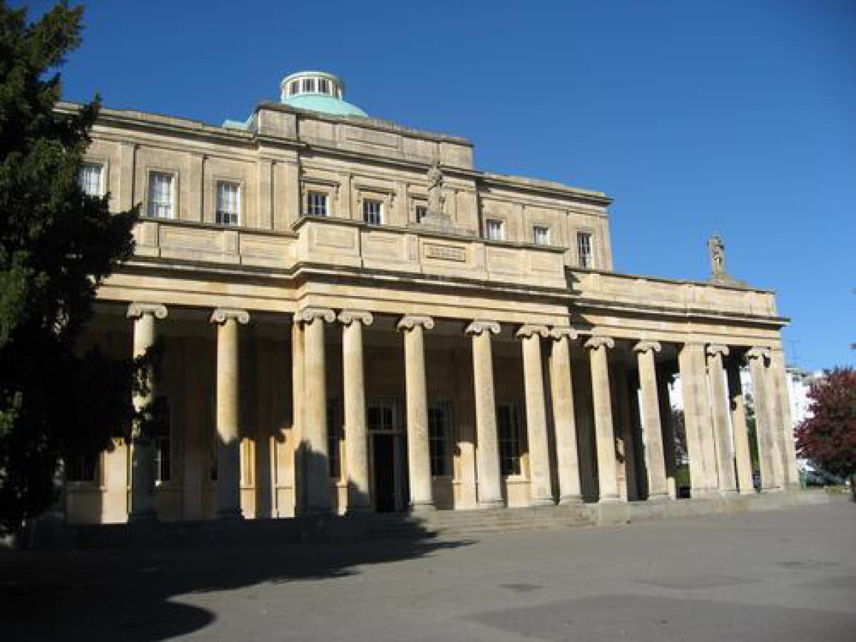
PRINCIPAL BUILDING
Pittville Pump Room (listed grade I) stands to the east of Evesham Road, in the north part of the original park (Pittville Gardens). Built 1825-30 for Joseph Pitt, by the architect John Forbes, it is a square, two-storey ashlar building in the Greek Revival style, based on engravings of the Temple of Illissus, near Athens. The roof is of slate and has a central copper dome. The east, south, and west sides are faced by Ionic columns. The main, central entrance is in the south face of the building.
GARDENS AND PLEASURE GROUNDS
Pittville Park is divided into two sections by Evesham Road. The original part, Pittville Gardens (8ha), was laid out by the nurseryman Richard Ware from 1825 to 1842, to the east of the road. Pittville Lake, a rough oval of c 1ha (built 1825-7 as a venue for boating and aquatic events) divides this part into two equal areas, with the Pump Room standing in the north part of the northern half. South of the lake is a thin strip of ground, c 450m long and 50m wide, running north/south. This is divided by the public road, Central Cross Drive, into two areas of broad lawn, edged by mainly mature deciduous trees, including planes, holm oaks, yews, and cedars. The park to the south of the lake is open to the public roads which enclose it on all but its north side. Many of the large Regency villas and terraces on the opposite sides of these roads are visible from the park.
Just north of Central Cross Drive is a small timber-framed former refreshment kiosk known as Essex Lodge or the Little Spa. The original building, at which medicinal waters were available, was demolished and replaced with the present structure, before 1910.
South of Central Cross Drive, a tarmac path runs around the edge of the lawn; north of the Drive there are both central and side paths. As they approach the lake, the central and east side paths both divide, one branch of each leading to each end (west and east) of the lake. Iron railings enclose the south side of the lake and a branch of the central path passes between a gap in the railings and leads to a narrow unsurfaced path around the southern edge of the lake. The lake is edged by a dense planting of shrubs and mixed, mature trees, including willows, holly, yew, ash, plane, and ornamental cherry. The planting is less dense on the northern bank, where the lakeside path is of tarmac and a small rockery has been built at the north-west edge of the lake. A path leads to the eastern of a pair of twin bridges (both listed grade II): of stone, with horizontal rustication and balustraded parapets, built 1830-40 to the designs of John Forbes. Some 10m to the south-east of the eastern end of the lake are the gates (listed grade II) marking the entrance to the drive of Pittville Gardens (which passes between a further pair of simple wrought-iron gates before continuing over the eastern bridge); these form a significant streetscape feature.
The paths leading to the west end of the lake come to the westernmost of the two bridges. Some 10m south-west of the bridge, another tarmac path leads down to a brick-built arched pedestrian underpass, which passes under Evesham Road to the western half of the park. The paths around Pittville Gardens were once more serpentine and the tree and shrub areas more extensive.
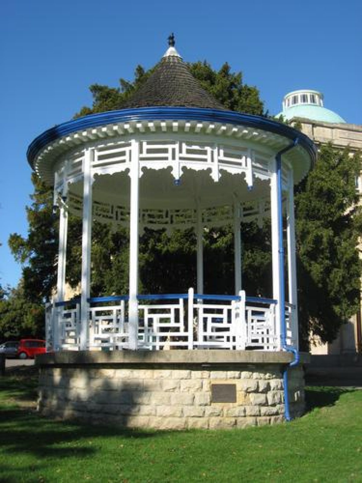
The section of the park to the east of Evesham Road and north of the lake is enclosed first by a low brick wall, then a wooden fence to the east and iron railings to the west. Broad tarmac paths (the eastern one of which is the original approach drive) lead north, along each side of the lawn, and converge on the Pump Room from which there are views south to the lake. The paths broaden into a car park surrounding the Pump Room on its west, north, and east sides and occupying an area which was originally part of the pleasure gardens. Some 10m from the south-west corner of the Pump Room is a small wooden bandstand, present by c 1940 (Blake 1996) and restored in 1995.
To the north-west of the lake a roughly square area of c 1ha is fenced off by C20 iron railings from Evesham Road and the rest of the park. The fence encloses a late C20 children's play area and a small zoo and aviary ('Peacock's Palace', built 1994). A small black and white toilet block, of timber and render, stands by the play area.
The western part of the park (25ha), known as the Marle Hill Annexe, is accessed via the underpass. Wyman's Brook, fed by Pittville Lake, flows west and is crossed by two small footbridges (concrete and wood on the original stone supports) before widening into Marle Hill Lake. Together, the brook and lake extend for c 600m. A broad gravel path leads around the edge of the lake. The small area of land between the park boundary and the south side of the east end of the lake is well-wooded, with mature trees including horse chestnut, yew, pines, and sycamore. A recently laid (late 1990s) beech hedge, in front of iron railings, separates the park from the allotment gardens to the south. A wooden footbridge crosses the lake c 15m from its east end and, c 10m east of the bridge, on the lake's north bank, is a timber and render boathouse, painted black and white.
South of the main body of the lake lies the Agg Gardner recreation ground: a c 3ha area of grass football pitches and a basketball court, which had been added to the site by 1913 (Plan). The recreation ground is screened from the lake by earthwork mounds planted with mature trees (mainly pines and birches). It is bounded by park railings and beech and horse chestnut trees to the east and by the walls of domestic back gardens to the south. A late C20 sports complex has been built at the western corner of this part of the park. It stands outside the boundary of the park as here registered and is partially fenced off from it.
At the west end of the lake is a small, densely wooded island with three mature small-leaved lime trees and younger, scrubby growth of sycamores and willows. The western end of the lake is dammed by a concrete edge. A small outlet stream flows over the edge, down a small rockwork cascade, parts of which have collapsed (1999). A small late C20 concrete footbridge crosses the stream c 50m from the western end of the lake; the stream disappears underground c 100m west of the bridge.
The eighteen-hole pitch and putt Approach Golf Course (c 8ha) occupies the park to the north of the lake, extending west to Tommy Taylor's Lane and east to c 150m from Evesham Road. It was laid out by the Council in 1952, on an earlier C20 landfill site (Cheltenham Borough Council pers comm, 2000). There are no barriers between the golf course and the road to its west and a late C20 housing estate to its north. From the course, there are views to the hills (including Cleeve Hill) on the north-east skyline. A single mature Wellingtonia stands to the east of the golf course and to the north-west of a group of tennis courts.
Pittville Gardens were laid out by Richard Ware from 1825 to 1842. The Marle Hill Annexe (the grounds of the C19 Marle Hill House) was probably joined to Pittville Gardens between 1885 and 1913, with Marle Hill Lake, also called Cappers Fish Pond (present by 1853, Harper, 1853-4), being the first part of it to be incorporated.
REFERENCES
L Griffiths, History of Cheltenham (1838)
G Hart, A History of Cheltenham (1965)
B Little, Cheltenham in pictures (1967)
Victoria History of the County of Gloucestershire VIII, (1968), pp 70-1
Cotswold Life, (January 1972), p 44
Gloucestershire Historical Studies VI, (1974-5), pp 58-60
D Verey, The Buildings of England: Gloucestershire The Vale and the Forest of Dean (2nd edition 1976, reprinted 1980)
Gloucestershire and Avon Life, (July 1980), pp 66-7
S Blake and R Beacham, The Book of Cheltenham (1982)
S Blake, Cheltenham: a pictorial history (1996)
Maps
Plan of the Pump Room at Pittville Spa and of the Drives, Promenades, Pleasure Grounds, Crescent, Squares and Buildings on his Estate near Cheltenham, 1826 [copy on EH file]
Plan of Pittville at Cheltenham, around 1830 (D3933/1), (Gloucestershire Record Office)
S C Harper, Plan of the town of Cheltenham and its vicinity, around 1853-4 (D3893/2/2), (Gloucestershire Record Office)
Pittville Gardens, Cheltenham, 1887 (Gloucestershire Record Office)
Large-scale plan of Cheltenham, 6" to 1 mile, 1913 (MA 14), (Gloucestershire Record Office)
OS 6" to 1 mile: 1st edition surveyed 1884-5, published 1887; 1924 edition
Description written: November 1999
Amended: February 2001
Edited: April 2003
- Visitor Access, Directions & Contacts
Telephone
01242 862352Access contact details
The park has free admission for the general public. The pump room is also a conference and wedding venue.
Directions
The park lies east of the A435 north of Cheltenham.
Owners
Cheltenham Borough Council
Municipal Offices Promenade, Cheltenham, Gloucestershire, GL50 9SA
- History
The following is from the Register of Parks and Gardens of Special Historic Interest. For the most up-to-date Register entry, please visit the The National Heritage List for England (NHLE):
www.historicengland.org.uk/listing/the-list
HISTORIC DEVELOPMENT
Pittville Pump Room and Gardens were built as a centrepiece for the town of Pittville, a development undertaken for the wealthy lawyer, banker, and MP for Cricklade, Joseph Pitt (who also built Cheltenham's Royal Crescent) from 1825 to 1842. Pitt obtained the land under the 1801 Enclosure Act which enclosed Cheltenham's common fields. Pittville's spa water was recommended for treating skin complaints and patients would take the waters, then promenade around the pleasure gardens. The year 1825 was a poor one for private bankers and property venturers and Pitt's plans for the town and spa of Pittville were checked, never subsequently coming fully to fruition (the villas and crescents shown on the plan of 1826 were never constructed). By the time the Gardens had been completed in the 1840s, the fashion of drinking English spa waters was beginning to wane and the distance from the town was an additional handicap to its success. Pitt died in about 1843, and by 1889 the spa had ceased to be profitable.
In 1838, the neighbouring Marle Hill was the seat of Lewis Griffiths Esq and the house was described as being 'delightfully situate on a gentle eminence, at the base of which is formed an extensive lake' (Griffiths 1838). In 1890, by which time part of the Marle Hill Annexe had been added to the Gardens, Cheltenham Borough Council bought the Pump Room and Gardens and laid out flower beds near the main entrance. By 1924 the Gardens were known as Pittville Park (Ordnance Survey). During the Second World War, the Pump Room was used as an American army depot and Nissen huts were erected on the lawns to its south. Damage and neglect almost caused the Pump Room to be demolished but it was restored and reopened in 1960, since when it has been used mainly for private functions.
The outer walks, as far as the bridges, were freely accessible to the public but up to 1954, an admission charge to the interior of the pleasure grounds was levied, and only patients and residents of the estate had free access. Today (1999), the Pump Room and Park remain in the ownership of the Borough Council; the waters can still be taken in the Pump Room.
- Associated People
- Features & Designations
Designations
The National Heritage List for England: Register of Parks and Gardens
- Reference: GD1103
- Grade: II
Features
- Pump Room (featured building)
- Description: The pump room was almost demolished in the 20th century, but was restored and re-opened in 1960. It is now a venue for weddings and other events.
- Earliest Date:
- Latest Date:
- Railings
- Description: Wrought-iron railings extend around part of the boundary east of the lake.
- Boundary Wall
- Description: A low brick wall and a wooden fence enclose the east side of the park.
- Lake
- Aviary
- Key Information
Type
Park
Purpose
Recreational/sport
Principal Building
Recreational
Survival
Extant
Hectares
33
Open to the public
Yes
- References
References
- Verey, David {The Buildings of England: Gloucestershire 2: The Vale and the Forest of Dean} (London: Penguin, 1970) The Buildings of England: Gloucestershire 2: The Vale and the Forest of Dean
- {English Heritage Register of Parks and Gardens of Special Historic Interest}, (Swindon: English Heritage, 2008) [on CD-ROM] Historic England Register of Parks and Gardens of Special Historic Interest
- Elrington, C.R. {Victoria County History: Gloucester, Volume 8} ([n.p.]: Oxford University Press, 1968), pp. 70-1 Victoria County History: Gloucester, Volume 8
- The Landscape Agency {Pittville Park Conservation Management Plan} (2008) Pittville Park Conservation Management Plan