Introduction
Packwood House dates from the 16th century, and stands in grounds occupying about 43 hectares. The formal gardens, which date from the mid-17th and early-18th centuries, cover about 2 hectares and feature yew topiary. The gardens are surrounded by 19th-century parkland.
Terrain
The site rises gently from the House towards the north, east and south.www.historicengland.org.uk/listing/the-list
Late 17th- and early 18th-century formal gardens with 18th- and mid-19th-century topiary, restored in the early 20th century, set in 19th-century parkland.
DESCRIPTION
LOCATION, AREA, BOUNDARIES, LANDFORM, SETTING
Packwood House is situated c 1.5km north-east of the village of Lapworth and c 10km north-west of Warwick, to the north of the B4439 road which runs north-west from Warwick to Hockley Heath. The c 43ha site comprises some 1.5ha of formal gardens, and c 41.5ha of parkland. To the north-west the site is bounded by a minor road, Grove Lane, which runs from Lapworth to Knowle; the road is separated from the park by a timber paling fence. The site adjoins agricultural land to the south-west, east and north-east, and is enclosed by hedges, while to the south the grounds of The Mount, an early C20 house, adjoin the park. A minor road, Grove Road, passes from north to south through the site, immediately to the east of the House. The site rises gently from the House towards the north, east and south, allowing views north-east across agricultural land from the north-east avenue. There are significant views west from Two Pits Park to the House and gardens, while from the west park there are internal views north and east. The west park adjoins the grounds of The Dower House, an early C20 house, which is visible some 500m south-west of the House.
ENTRANCES AND APPROACHES
Packwood House is today (1999) approached from Grove Road, the minor road which runs from north to south through the site. The road passes through a forecourt to the east of the House which is enclosed to the south and north by brick walls which flank tall, rusticated brick piers surmounted by pyramidal brick caps. To the east the forecourt is enclosed by a buttressed brick wall which retains Two Pits Park at a higher level to the east. The park is approached by a flight of semicircular brick steps aligned on the east facade of the House. At the top of the steps a simple wrought-iron gate set in a wrought-iron screen c 10m long leads to a footpath within the north-east avenue which extends through Two Pits Park to join Chessetts Wood Road c 1km north-east of the House. The forecourt is enclosed to the south-west by the mid C17 walls of the south garden (listed grade II), while to the north-west it adjoins mid C17 barns, stables and outbuildings (listed grade I). On the east side of the road are further stables (listed grade II), while the gravelled yard to the north, which adjoins kennels (now visitors' toilets) and a barn to the north-west, is used as the late C20 visitors' car park. Within the forecourt the road is flanked by wide grass verges edged with short oak posts; to the east-north-east an early C20 semicircular yew arbour (OS) is aligned on the entrance doors leading to the C17 stables north-east of the House. A gravelled carriage turn with a central octagonal lawn lies to the west of the road, below a pair of early C20 ornamental wrought-iron gates which are supported by a pair of mid C17 rusticated brick piers surmounted by stone ball finials (listed grade II). The gateway is placed centrally in a mid C17 brick wall (listed grade II) which forms the eastern boundary of the east garden, and is aligned on the front door of the House. A stone-flagged walk flanked by standard bay trees in wooden tubs leads through the east garden to a shallow flight of stone steps which ascends to the door.
To the north of the stables north-east of the House, an elaborate wrought-iron gate surmounted by an overthrow incorporating an heraldic device is set in a high, mid C17 brick wall, and is flanked by tall brick piers with brick and stone pyramidal finials. The gate gives access to a gravelled drive which leads through the north garden to a pair of tall brick piers with pyramidal caps. Turning south along the west front of the House the north-east drive approaches a gravelled carriage court which today (1999) forms the west garden. The west garden or carriage court is bounded by yew hedges to the south, west and north-west which enclose a gravelled turning circle with a central octagonal lawn which is ornamented with a mid C17 stone column sundial (listed grade II).
An entrance from Grove Lane c 450m south-west of the House is closed by level-topped wrought-iron gates which are supported on rusticated brick piers with pyramidal brick and stone finials similar to those in the forecourt. The entrance leads to a grass track which passes north-east across the west park through an avenue of oaks. Crossing the brick-lined dam at the north-west end of the lake, the track enters the gardens west of the House. In the C18 the western avenue formed the principal approach to the House, with what is today (1999) the west garden forming the entrance court.
PRINCIPAL BUILDING
Packwood House (listed grade I) stands towards the centre of the site, immediately to the west of Grove Road. The late C16 house is roughly square on plan with projecting full-height gabled porches on the east and west facades. To the north-east is an extensive range of mid C17 brick outbuildings which form a U-shaped range open to the north (listed grade I). The east range of the outbuildings contains an arched carriage entrance to stables, above which is a painted sundial. There is a further sundial on the south facade of the south range, and the roofs of both ranges are ornamented with louvered turrets. The house is of two storeys with attic gables, while the outbuildings are principally of one storey with attic gables. The house is of timber-framed construction, but the framing has been covered with cement render since the early C19 (Tyack 1994); its former appearance is shown on a drawing of c 1756 (private collection). Packwood House underwent an extensive restoration programme in 1925-32 which was supervised by Edwin Reynolds (CL 1989; Tyack 1994). This included alterations to the interior, replacement of C19 fenestration with timber mullion and transom windows, and the construction of the single-storey Gallery which linked the north-west corner of the C16 house to a C17 or C18 barn to the north, which was converted into a Great Hall.
GARDENS AND PLEASURE GROUNDS
There are formal gardens on all sides of the House, with areas of informal pleasure grounds adjacent to the lake to the south-west and west.
The east garden lies between the forecourt and the entrance to the House, and is enclosed to the north by the mid C17 brick outbuildings, and to the south by a high, mid C17 brick wall (listed grade II) which contains heating flues for wall-trained fruit trees. A central stone-flagged walk flanked by rectangular panels of lawn leads west from the entrance gates to the front door of the House. There are perimeter flower borders with climbing plants trained against the House, outbuildings and east wall; mature cherries grow against the north face of the heated south wall. A stone-flagged walk leads south from the front door to a wrought-iron gate set in the brick wall at the south-west corner of the garden, which gives access to the south garden.
The south garden comprises a rectangular lawn which is enclosed by high, mid C17 brick walls (listed grade II) to the east and west, and by a mid C17 raised terrace walk to the south which is approached by a flight of semicircular brick steps flanked by brick piers with carved stone urns. The steps are aligned on the south door of the House. To the north of the south garden a small stone-flagged terrace enclosed by low brick walls covered with climbing roses to the south-east and south-west lies immediately below the south facade of the House; a small niche containing a pool and wall fountain is set into the east wall. Each corner of the south garden is marked by a brick gazebo of square plan (all listed grade II) ornamented with corner pilasters. The mid C17 north-east and north-west gazebos have pyramidal tiled roofs and are of two storeys with ground- and first-floor timber doors facing the garden. The south-west gazebo is believed to be mid C17, while that to the south-east was rebuilt in the early C20 as part of Baron Ash's restoration of the garden. The southern gazebos terminate the raised south terrace to east and west, and have flat roofs with arched entrances facing along the terrace, and north to semicircular brick steps which descend to the garden. The south-west gazebo contains a painted timber bench and a circular stone table supported on a brick pedestal; an oval window in the south wall is surrounded by shells. The south-east gazebo contains a timber bench seat. The south terrace walk comprises a stone-flagged walk flanked by herbaceous borders, and a low parapet wall to the south allows views across the topiary garden.
Climbers and flowering shrubs are trained against the west wall, in the centre of which is set an elaborate wrought-iron gate and overthrow which is supported by rusticated brick piers surmounted by stone vase finials. The west gateway, which leads to the informal pleasure grounds by the lake and which formerly allowed a view of the early C20 Victory Vase (vase missing, 1999) c 50m south-west of the House, was installed in 1935 to commemorate the Silver Jubilee of King George V. There are flower beds below the north-east and east walls, that to the east being a rose border which is edged with a low yew hedge and divided by yew buttresses; it was created by Baron Ash in the early C20. The eastern third of the south lawn is occupied by a rectangular, yew-hedged sunken garden. The sunken garden is entered from the north, with brick steps descending to a sunken rectangular lawn which surrounds a stone-edged rectangular lily pool with a lead figure-group fountain at the southern end. The sunken lawn is enclosed by low brick and stone coped walls which retain herbaceous borders. The sunken garden formed part of Baron Ash's developments in the early 1930s. Other features which were added in the 1920s and early 1930s, including a gravel walk flanked by herbaceous borders which linked the south door of the House to the steps ascending to the south terrace, yew topiary and specimen trees were removed after the Second World War (Lady Rockley 1935; guidebook).
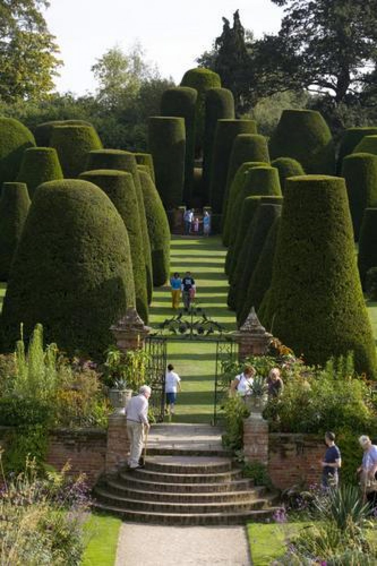
The topiary garden to the south of the south garden is entered through an ornamental wrought-iron gate with an overthrow which is supported on rusticated brick piers with pyramidal caps (listed grade II). This is situated on the raised south terrace on an axis with the south facade of the House. Semicircular brick steps descend from the gate to the level of the topiary garden, and at the base of the south face of the terrace retaining wall are fifteen pairs of arched recesses for bee skips. These are shown on the drawing of 1756 (private collection). The topiary garden comprises a gently sloping rectangular lawn which ascends south to a low, raised transverse walk. The lawn is enclosed to the east and west by box hedges and is planted with clipped yew cones c 5m high which are arranged in a symmetrical pattern. The lawn is divided into quarters with the perimeter of each quarter being marked by a single row of yews. The east/west axis is aligned to the east on a square clipped yew arbour which shelters a stone-flagged terrace and a stone bust supported on a stone plinth. The north/south axis forms the central walk through the topiary garden which leads to semicircular brick steps ascending to the box-hedged, brick transverse walk. To the east and west of the steps the transverse walk is lined with two rows of four tall yews which alternate with low box domes. Beyond the transverse walk, on the central axis of the garden, rises a mount which is ascended by a clockwise spiral gravel walk retained by brick walls and enclosed by low, wide box hedges. The summit of the mount forms a level gravelled area in which grows a single tall yew cone, sometimes known as the Master or Pinnacle of the Temple (guidebook). The mount and transverse walk are shown on estate plans dating from 1723 (Fish) and 1783 (Wedge), but in the C18 the lower topiary garden was an enclosed orchard. The yews in the lower topiary garden were planted in the mid C19 (Elliott 1989), probably by George Arton after he acquired the property in 1869. Blomfield (1901) suggested that the whole topiary garden was a late C17 or early C18 survival, and reported that the gardener, 'who was pleaching the pinnacle of the temple' explained the garden as a representation of the Sermon on the Mount.
The north garden is enclosed by high brick walls to the west and east, and by a lower brick wall to the north which allows views through an area of trees and shrubs to the park. To the south a screen wall links the north-west corner of the outbuildings and the north-east corner of the Great Hall and encloses the service court. The north drive is adjoined by lawns to the north and south, and box topiary figures are placed along its edge in wooden tubs. A brick-lined rectangular pool extends south from the mid-point of the north wall of the garden, and is fed by a lead lion-mask spout. To the north-west of the House an area of informal lawns is separated from the park by an L-shaped pool which is fed by the outflow from the lake; this is shown on the 1723 estate plan. Some 30m north-west of the House a late C17 plunge pool (listed grade II) is enclosed by yew hedges with a pair of brick piers surmounted by terracotta finials to the south-west and north-west. The brick-lined, stone-edged plunge pool is rectangular on plan with stone steps descending at the south-west corner. To the west a square, stone, ogee-roofed faucet is ornamented with a carved coat of arms. The informal lawns extend south-west to the west of the House and the south garden, on the east side of the lake. Some 50m south-west of the House an early C20 square brick pedestal formerly supported the Victory Vase (vase missing, 1999).
PARK
The park lies to the east and west of the House, and is divided from north to south by Grove Road. Two Pits Park to the east remains grazed meadow and is crossed from west-south-west to east-north-east by a mixed avenue of deciduous trees. To the east, south-east and south the park is enclosed by mixed woodland. Two square ponds flank the gate leading from the park to the eastern avenue c 400m north-east of the House, while an L-shaped pond lies in Brick Kiln Coppice c 240m south-east of the House. Two further parkland enclosures lie to the north of Two Pits Park, rising gently to Pavis Cottage, an early C20 estate worker's cottage c 450m north of the House. The eastern park is shown as agricultural land on the 1723 and 1783 estate plans, but a path following the line of the present eastern avenue, and the three ponds, are shown in 1723. The eastern parkland had assumed its present form by 1886 (OS).
The west park is today (1999) a series of large meadow enclosures divided by fences with scattered mature deciduous trees, some of which survive from earlier field boundaries. The north-west boundary adjacent to Grove Lane is screened by a plantation of pines which to the south-west broadens into a mixed wood, The Grove, which was recorded on the 1723 estate plan. A marshy pool on the eastern fringe of The Grove, c 200m north-west of the House, survives from two pools shown in 1723. Between The Grove and the west avenue the park is characterised by scattered oaks, some of which survive from an C18 avenue which extended c 270m south-south-east from the south-east corner of The Grove to the south-west corner of the lake (estate plan, 1723). Remains of this avenue are shown on the 1783 estate plan, but no trace survives to the south of the point at which it crossed the west avenue. The L-shaped lake c 50m south-west of the House is the principal feature of the parkland to the south of the west avenue. To the south-south-east the lake merges with an area of marshy woodland, Pool Tail Coppice, which adjoins the grounds of The Mount (outside the site here registered). Some 130m south-west of the lake the park is crossed from west to south-east by a ditch which marks the course of a track or road which, until the late C18, ran east from Lapworth to Rising Lane (estate plans, 1723, 1783). In the late C19 the west park extended south-west towards Lapworth, taking in ground which was used c 1925 for The Dower House (outside the site here registered) (OS).
KITCHEN GARDEN
The kitchen garden lies to the east the stables and barn on the east side of Grove Road, c 100m north-east of the House. It is enclosed by high brick walls to the north and east, with lower brick walls to the south and south-west, and the east facade of the stables to the west. Arched timber doors are set in the north, west and south walls, and the interior of the garden is laid out with a central north/south gravel walk and a series of box-edged beds separated by transverse gravel walks. The beds are planted principally with herbaceous plants, while standard apple trees grow parallel to the western boundary, and espalier pears are trained against the east wall. An early C20 brick and timber lean-to glasshouse survives against the north-west wall, while a late C20 metal-framed glasshouse stands against the north-east wall, replacing an earlier timber-framed house. A range of brick frames survive to the south of the glasshouses, while a brick bothy stands against the outer face of the north-east wall. The late C20 arrangement of walks and beds within the kitchen garden reflects that shown on the 1723 estate plan.
REFERENCES
West, Directory of Warwickshire (1830)
R Blomfield, The Formal Garden in England (3rd edition 1901), pp 72, 111, 182
Country Life, 11 (4 January 1902), pp 16-24; 56 (9 August 1924), pp 218-24; (16 August 1924), pp 250-7; 183 (19 October 1989), pp 108-13
C Holme, Gardens of England in the Midland and Eastern Counties (1908), pl 96
G Jekyll, Garden Ornament (1918), p 71
G Jekyll and L Weaver, Gardens for Small Country Houses (4th edition 1920), pp 200, 206
Landscape and Garden 2, no 2 (1935), pp 61-4
Lady Rockley, Historic Gardens of England (1938), p 128
N Pevsner and A Wedgewood, The Buildings of England: Warwickshire (1966), pp 370-1
R Strong, The Renaissance Garden in England (1979), pp 211-14
B Elliott, Victorian Gardens (1989), pp 120-1, 227
G Tyack, Warwickshire Country Houses (1994), pp 158-61
Packwood House, guidebook, (National Trust 1981, revised edition 1998)
Maps [all held in Warwickshire County Record Office]
J Fish, The Survey of part of the Manours of Packwood & Knowle in ye County of Warwick being the Lands of ye Worshipful Thomas Leigh Fetherston Esqr, 1723 (Z230u)
T Wedge, Survey of the Packwood Estate, 1783 (Z233u)
Tithe map for Packwood parish, around 1840 (CR328/33)
Tithe map for Lapworth parish, around 1843 (CR328/30)
OS Maps
OS Old Series 1" to 1 mile, published 1831
OS 6" to 1 mile: 1st edition published 1886; 2nd edition published 1906; 3rd edition published 1926; 1938 edition
OS 25" to 1 mile: 1st edition published 1886; 2nd edition published 1905; 3rd edition published 1918; 1925 edition
Illustrations
Watercolour, The South View of Packwood House in the County of Warwick, around 1756 (private collection)
Photographs, Packwood House and gardens, 1930s (National Trust Collection)
Archival items
Fetherston family papers, including inventory of 1634 (DR12/27), (Shakespeare Birthplace Trust Record Office)
Description written: December 1999
Amended: May 2000
Edited: January 2001
- Visitor Access, Directions & Contacts
Telephone
01564 782024Access contact details
The site is open from March to October, Wednesday to Sunday. Core hours 11am to 4.30pm. Please check for variations: http://www.nationaltrust.org.uk/place-pages/255/pages/opening-times-calendar
Directions
North of Lapworth, to the north-east of the M40 junction 16.
- History
The following is from the Register of Parks and Gardens of Special Historic Interest. For the most up-to-date Register entry, please visit the The National Heritage List for England (NHLE):
www.historicengland.org.uk/listing/the-list
HISTORIC DEVELOPMENT
The Fetherston family were established as yeomen farmers in the parish of Packwood in the 15th century, and gradually built up a small estate. Packwood House was built in the late 16th century by William Fetherston (died 1601), and while it was not the manor house, it became the most important house in the parish because the lords of the manor were non-resident. It was described as the 'great mancient house' in 1599 when William Fetherston transferred his property to his son, John. At John's death in 1634 the estate was inherited by his son, also John Fetherston, who had trained as a lawyer and had married a local heiress. John Fetherston II built the stables and farm buildings adjacent to the house in the mid-17th century, and either he, or his son Thomas, who inherited in 1670, was responsible for creating garden enclosures and a cold bath (Tyack 1994). Thomas Fetherston (died 1714) left the estate to his sister, who was married to Thomas Leigh of Aldridge, Staffordshire; it subsequently passed to their daughter, Catherine, who died a spinster in 1769. After Catherine's death, Packwood was inherited by her half-nephew, Thomas (born 1761), younger son of William Dilke of Maxstoke Castle, Warwickshire. Thomas Dilke died in 1814 leaving the estate to his brother Charles, who was described as living in 'the true style of an English gentleman' (West 1830). The house was modernised in the early 19th century, but the gardens remained largely untouched. Packwood remained in the Dilke family after Charles' death in 1831, but from 1851 it was let.
In 1869 it was sold to George Arton who developed the gardens and created the parkland from surrounding agricultural land in the 1870s (OS). Reginald Blomfield (1856-1942) included a description of Packwood in The Formal Garden in England and in the late 19th century and early 20th century Packwood became noted as an example of an 'old English garden' (Country Life 1902; Jekyll and Weaver 1920). At Arton's death in 1904 Packwood was sold to Alfred Ash, a Birmingham metal manufacturer, who was described as viewing life 'from the sunny side - and from the interior of a gorgeous Rolls-Royce' (obituary, 1925). Ash bought the estate for his son, Graham Baron Ash, known as Baron Ash, who made a thorough restoration of the house in 1925-32 under the supervision of the Birmingham architect Edwin Reynolds (1875-1949). Ash housed his extensive collections of furniture and other 16th- and 17th-century artefacts, many acquired in the 1930s from neighbouring Baddesley Clinton Hall (see description of this site elsewhere in the Register), at Packwood; he also sought to 'rescue' features from old properties which faced demolition in the inter-war period. Baron Ash entertained lavishly at Packwood, particularly in 1938 when he served as High Sheriff of Warwickshire. In 1941 he gave the estate to the National Trust, and in 1947 moved to Wingfield Castle, Suffolk, which he also restored. Baron Ash died in 1980 and today (1999) Packwood remains the property of the National Trust.
- Features & Designations
Designations
The National Heritage List for England: Register of Parks and Gardens
- Reference: GD2199
- Grade: II*
Features
- Bee Bole
- Topiary
- Herbaceous Border
- Walk
- Lake
- House (featured building)
- Description: Packwood House was built in the late 16th century by William Fetherston. It was restored in the 1920s under the supervision of the Birmingham architect Edwin Reynolds.
- Earliest Date:
- Latest Date:
- Key Information
Type
Garden
Purpose
Ornamental
Principal Building
Domestic / Residential
Survival
Extant
Hectares
43
Open to the public
Yes
Civil Parish
Lapworth
- References
References
- Jekyll, G., {Garden Ornament} (London: Country Life, 1918), p. 71 Garden Ornament
- {English Heritage Register of Parks and Gardens of Special Historic Interest}, (Swindon: English Heritage, 2008) [on CD-ROM] Historic England Register of Parks and Gardens of Special Historic Interest
- Elliott, B., {Victorian Gardens} (London: Batsford, 1986), pp. 120-1, 227 Victorian Gardens
- Strong, R. C., {The Renaissance Garden in England} (London: Thames and Hudson, 1979), pp. 211-4 The Renaissance Garden in England
- Pevsner, N. and A. Wedgwood, {The Buildings of England: Warwickshire} (Harmondsworth: Penguin Books, 1966), pp. 370-1 The Buildings of England: Warwickshire
- Tyack, G., {Warwickshire Country Houses} (Chichester: Phillimore, 1994), pp. 158-61 Warwickshire Country Houses
- Holme, C. G., {The Gardens of England in the Midland and Eastern Counties} ([n.p]: Studio, 1908), plate 96 The Gardens of England in the Midland and Eastern Counties
- Nicholas Pearson Associates {Packwood Parkland Plan} (2011) Packwood Parkland Plan