Introduction
Baddesley Hall is a medieval moated manor house with a courtyard garden of about 0.2 hectares, and surrounding lawn, fields, orchard and woodland occupying 33 hectares in total. The earliest surviving details in the gardens are a series of fishponds dug in 1444. Other features include a Victorian lakeside walk, a nature trail, and a late-19th-century formal garden.
Terrain
The parkland rises gently from the house to the north, east and south, while to the west and south-west of the house the ground falls towards a stream and three medieval fishponds.www.historicengland.org.uk/listing/the-list
An 18th-century walled garden with medieval fishponds and 19th-century pleasure grounds, and 16th- and 19th-century parkland, surrounding a moated medieval manor house.
LOCATION, AREA, BOUNDARIES, LANDFORM, SETTING
Baddesley Clinton Hall is situated c 1.25km south-west of the village of Baddesley Clinton and c 10km north-west of Warwick. The c 33ha site comprises some 4ha of gardens, pleasure grounds and ponds, and c 29ha of parkland. To the north the site is bounded by a minor road, Rising Lane, which leads west from Baddesley Clinton to Kingswood, while to the east, south and west the site adjoins agricultural land and is enclosed by fences and hedges. The parkland rises gently from the house to the north, east and south, while to the west and south-west of the house the ground falls towards a stream and three medieval fishponds. There are significant views from the gardens north and south-east across the park and farmland, and from the northern park in a westerly direction across surrounding agricultural land towards Kingswood.
ENTRANCES AND APPROACHES
Baddesley Clinton Hall is approached from the minor road which forms the northern site boundary at a point c 0.75km west of Baddesley Clinton village. The tarmac and gravel drive ascends south-south-east between timber paling for c 30m to reach a late C19 single-storey lodge which stands to the west of the drive. The lodge is constructed in stone with Tudor-gothic mullioned windows below half-timbered gables ornamented with coloured shields, and was constructed for Edward Dering c 1890. Immediately south of the lodge the drive passes through a timber five-bar gate and enters an avenue of limes which extends c 190m south-south-east through the park. Turning south-east the drive continues for c 260m along the north-east boundary of the park before turning sharply south adjacent to a copse known as Badger's Dell, in which is located the medieval quarry from which stone for the house was dug. The drive extends c 350m south-south-west through the park to reach a pair of C19 ornamental timber gates supported on timber posts with ogee finials and set in a timber pale fence which encloses the pleasure grounds around the house. Some 20m north of this gateway an C18 brick-lined carriage wash lies to the west of the drive. A service drive turns south-east to reach the late C20 car park and visitors' entrance, while the principal drive turns south-west and passes between lawns to reach the gravelled forecourt which lies to the north-east of the house. To the south-east of the forecourt a further service drive leads to the C18 stable and farmyard (all listed grade II) which replaced late medieval stone barns and farm buildings c 50m north-east of the house. These buildings were destroyed by fire, and their earthwork remains are visible in the lawns north of the drive. The forecourt is enclosed to the north-east by a C19 low, coursed stone wall (listed grade II) which flanks a pair of late C19 rusticated gate piers surmounted by acorn finials (all listed grade II). The present walls and gate piers replaced early C18 panelled piers surmounted by urns and flanked by low walls and a painted timber palisade, the remnants of which are shown in the early C19 watercolour in the Aylesford Collection. The C18 walls in turn replaced an early C15 timber gatehouse which guarded an outer moat, the line of which is visible in the lawn north of the drive. To the south-west the forecourt adjoins the inner moat, which is crossed by an early C18 two-arched brick bridge (listed grade I) which leads to the C15 and late C16 gatehouse. The south-east side of the forecourt is formed by the early C18 brick stables (listed grade II) which have attic dormers and a C19 ornamental cupola set in the tiled roof.
A further drive, today (1999) a footpath, approaches the house from a minor road, Hay Lane, to the south-east. Now known as Church Walk, the footpath extends c 160m north-west from Hay Lane to reach the churchyard of St James' church which stands c 320m east-south-east of the house. Passing through the churchyard adjacent to its southern boundary, the path leads through a timber gate and continues for c 270m north-west to reach the service drive east of the farmyard. To the west of the churchyard the Church Walk has views south-west across the park, while to the north-east it is enclosed by mature trees and shrubbery. This path formed the principal approach to the medieval house, while the present principal approach was developed from a medieval drove track in the early C18 (estate map, 1699; guidebook).
PRINCIPAL BUILDING
Baddesley Clinton Hall (listed grade I) is a C15 moated courtyard house which stands on the site of an earlier moated dwelling. The walls of the house rise directly from the water, and today (1999) the central courtyard is surrounded by ranges to the east, south and west; the north range, probably containing the great hall, was demolished in the early C18 when Edward Ferrers made various improvements to the house. The east range contains the gatehouse and dining room, while the south range contains the hall. The west or family range contains service rooms on the ground floor. The house is constructed in stone quarried in the park (guidebook), and is principally of two storeys under pitched tiled roofs. The south range was re-faced in brick by Edward Ferrers in the early C18, while the west range was extended into the courtyard by Edward Dering to his own design in 1890. The inner west range is built of concrete blocks and imitation timber framing which echoes that of the adjacent gables on the inner facade of the south range. The entrance is set in the gatehouse on the east facade, which was built in the C15 and altered in the early C17 when Henry Ferrers the Antiquary built the Great Parlour on the first floor. Originally gabled, the gatehouse received its present crenellated parapet in the early C19 (Tyack 1994).
GARDENS AND PLEASURE GROUNDS
Informal pleasure grounds lie to the north and west of the house, while a formal walled garden lies to the south. The central courtyard of the house is also laid out as a formal garden.
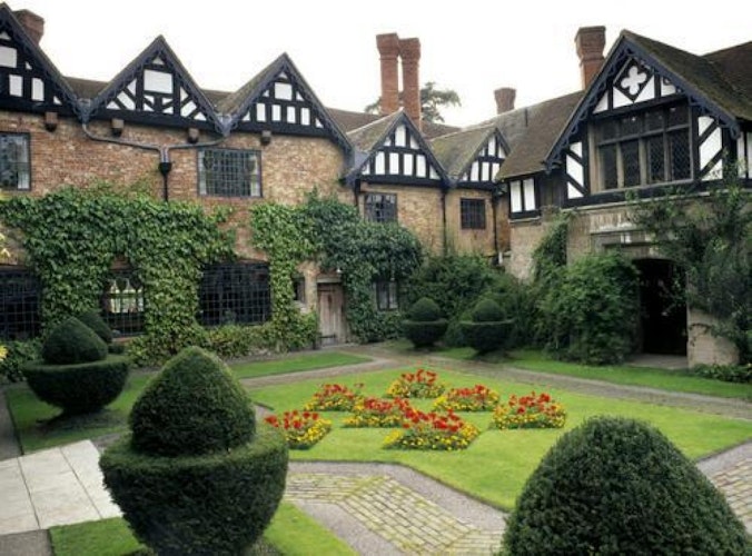
The courtyard garden comprises a central geometrical lawn in which are cut seven closely spaced diamond-shaped beds which are planted with yellow- and red-flowered seasonal bedding. The shape and colour represent the main charge of the Ferrers arms. The lawn is enclosed by brick and gravel-edged paths, while narrow outer lawns are planted with topiary yew acorns. The walls of the courtyard are lavishly planted with climbing subjects. The courtyard garden was laid out in its present form by Edward Dering in 1889 (guidebook).
The walled garden is enclosed to the north-east by the west facade of the early C18 stables and farm buildings (listed grade II), and to the south-west by an C18 brick wall c 3m high. The south-east boundary is formed by a lower brick wall, partly rebuilt in the mid C20, which allows views out across the south park and fields on rising ground beyond. To the north an ivy-covered bank descends from the walled garden to the moat, beyond which stands the south facade of the house. A simple stone, square-section pedestal supports a sundial (restored late C20), which stands at the centre of a large rectangular lawn which occupies the central area of the walled enclosure. The sundial is flanked by four segmental rose beds, while late C20 standard apple trees in traditional varieties are planted towards the outer edges of the lawn. A gravelled perimeter walk encircles the lawn. To the south-west the walk passes between herbaceous borders, while to the north-east the walk is flanked by mixed borders and a series of matching stepped, square-section topiary shapes in clipped box. The north-east walk is aligned to the south-east on a brick arch-fronted alcove, known as the Donkey House but in the C19 used as a peacock roost (ibid), which today (1999) contains an ornamental late C19 timber seat. The south-east walk is flanked by a narrow bed below the garden wall, while at the south-west and north-east corners of the garden late C20 raised brick-paved platforms allow views across the parkland. The raised platforms are adjoined by segmental beds planted with herbs. The present layout of the walled garden has been developed by the National Trust in the late C20, and is based on early C20 watercolours by A E Lilley (National Trust Collection). In the late C19 the walled garden was developed as an ornamental kitchen garden with herbaceous borders, a perimeter pergola and high yew hedges to the north (guidebook).
An ornamental wrought-iron gate set in an arched opening at the south-west corner of the walled garden leads to the pleasure grounds to the west of the house. Three C19 brick and timber lean-to glasshouses, one planted as a vinery, stand against the outer face of the south-west wall of the walled garden overlooking a sloping lawn which descends west towards the lake. Adjacent to the hedge which separates the pleasure grounds from the south park, the Undine Walk, named in memory of Mrs Thomas Ferrers (d 1962), comprises an avenue of flowering cherries underplanted with pampas grass. This replaced a further area of C19 kitchen garden which was abandoned c 1970 (ibid). The nuttery to the north-west, comprising four rows of cob nuts, was planted c 1980 and adjoins a mid C19 rustic timber hut. Mown grass paths encircle a sloping lawn which was planted as a wildflower meadow by Thomas Ferrers-Walker in the 1950s. Some 130m south-west of the house the lake or Great Pool is an irregular-shaped artificial pond which is retained by a dam to the west. Informal woodland walks follow the banks of the lake, passing beneath mature broadleaf trees underplanted with rhododendrons and evergreen shrubs. To the north the walk is carried over the inlet to the lake on a rustic timber bridge with saltire-patterned balustrades which was constructed in 1996 following a C19 pattern (ibid). The lake may have originated as a mill pond, but by 1699 the associated mill did not remain (estate plan, 1699). In 1748 Thomas Ferrers made 'the Loer garden' which contained new turf walks and, by 1751, a cold bath, which appear to have formed a lakeside walk (guidebook). The cold bath does not survive, but c 1860 Rebecca Ferrers developed the surviving northern section of the lakeside walk as an informal carriage drive (ibid). Two medieval fish ponds are situated on higher ground to the north-east of the lake, some 30m north-west of the house. The larger, southern pond extends c 50m from north-east to south-west, while the smaller pond lies to the north and extends c 30m from north-west to south-east. The fishponds were excavated for John Brome in 1444 (ibid). The ponds lie at the west end of the Shrubbery, which extends north-east between the forecourt and park boundary, and to the north of the east lawn. Evergreen shrubbery growing below mixed mature trees survives from the C19 shrubbery, which was simplified and reduced in the mid and late C20. Some 50m north-north-west of the house a circular stone seat ornamented with four animal figures carved by Jonathan Protheroe was installed in 1994 to commemorate Mary Fitter.
PARK
Parkland lies to the north and south-east of the house. The north park is today (1999) meadow with scattered deciduous trees, and is divided into four enclosures which correspond to those shown on the estate plan of 1699. The present north park includes the late C17 Milking Yard north of the house, the 'Hithermost Peece of ye Parke', 'The Lane Peece' which adjoined Rising Lane to the north, and the 'Barne Field' to the east of the drive (estate plan, 1699). Barn Field today accommodates the late C20 visitors' car park adjacent to its southern boundary. The late C17 north park included two further enclosures to the north-east: 'Midle Peece of the Parke', and 'Further Peece of the Parke' which adjoined Park Farm at the junction of Rising Lane and Hay Lane c 1km north-east of the house. These enclosures had ceased to form part of the park by the late C19 (OS), and are agricultural land today. The north park was enclosed in the early C16 by Nicholas Brome, and was marked on Speed's map of Warwickshire (1610). It assumed its present form in the early C18 when Thomas Ferrers planted oaks and developed the present approach from an earlier track (guidebook). Further improvements, including the planting of the lime avenue c 670m north of the house, were made in the late C19 by Edward Dering.
The south-east park comprises a meadow enclosure on rising ground to the south-east of the walled garden. To the north-east the south-east park is bounded by the Church Walk and the parish church, while to the south-east and south-west it is separated from adjacent agricultural land by hedges. A clump of ornamental trees including pines grows c 100m south of the house, while extensive areas of ridge and furrow survive in the park. The 1699 estate plan describes the south-east park as 'Churchfield', and it appears to have remained as agricultural land until the C19 when it was developed as parkland by Marmion Ferrers and Edward Dering.
KITCHEN GARDEN
The walled garden to the south of the house was used as an ornamental kitchen garden in the late C19 (guidebook; watercolours by A E Lilley), but fell into disuse in the 1920s. A further area of kitchen garden to the south-west of the walled garden was similarly abandoned in the 1970s. Today (1999) there is no kitchen garden at Baddesley Clinton.
REFERENCES
W Dugdale, The Antiquities of Warwickshire, (2nd edn 1730), p 970
W Niven, Illustrations of Old Warwickshire Houses (1878)
Trans Birmingham Archaeological Society 17, (1891), pp 74-99
Country Life, 1 (8 January 1897), pp 20-2; 18 (30 December 1905), pp 942-52; 71 (30 April 1932), pp 498-500; 163 (22 June 1978), pp 1802-5; (29 June 1978), pp 1866-9; 167 (3 April 1980), p 1005
H Norris, Baddesley Clinton (1897)
C Holme, The Gardens of England in the Midland and Eastern Counties (1908), p 23, pl 8
Victoria History of the County of Warwick IV, (1947), pp 13-17
N Pevsner and A Wedgewood, The Buildings of England: Warwickshire (1966), pp 81-2
G Tyack, The Making of the Warwickshire Country House 1500-1650 (1982), pp 19-21, 57-8
G Tyack, The Country Houses of Warwickshire 1800-1939 (1989), pp 13, 51, 57
M Hall, The English Country House (1994), p 8
G Tyack, Warwickshire Country Houses (1994), pp 23-7
Baddesley Clinton, guidebook, (National Trust 1998)
Maps
J Speed, The Countie of Warwick, 1610
W Clark, A Mapp of the Lordshipp of Badsli, 1699 (Z234L), (Warwickshire County Record Office)
H Beighton, A Mapp of Warwickshire, 1" to 1 mile, surveyed 1722-5, published 1729
H Beighton, A Map of Barlichway Hundred, surveyed 1725, published 1730
W Yates and Sons, Map of Warwickshire, surveyed 1787-9, published 1793
C and J Greenwood, Map of Warwickshire, 1822
OS Old Series 1" to 1 mile, published 1831
OS 6" to 1 mile:
1st edition published 1886
2nd edition published 1906
1938 edition
OS 25" to 1 mile:
1st edition published 1886
2nd edition published 1905
1925 edition
Illustrations
Watercolour, Baddesley Hall, c 1800 (Aylesford Collection, Birmingham Reference Library Archive)
A E Lilley, Views of the walled garden, c 1915 (National Trust Collection)
Archival items
Ferrers family papers including estate accounts are held at the Shakespeare Birthplace Trust Record Office.
Description written: December 1999 Amended: May 2000
Register Inspector: JML
Edited: December 2000
- Visitor Access, Directions & Contacts
Telephone
1564783294Access contact details
01 564 783294 Core opening hours for grounds: March to November, 12 noon to 4pm. Check for variations.
Directions
5 miles south-east of Solihull. 6 miles south of M42 exit 5.
Owners
The National Trust
- History
The following is from the Register of Parks and Gardens of Special Historic Interest. For the most up-to-date Register entry, please visit the The National Heritage List for England (NHLE):
www.historicengland.org.uk/listing/the-list
HISTORIC DEVELOPMENT
Baddesley Clinton originated as a clearing in the Forest of Arden, named after the Saxon Baeddi (guidebook). The manor was acquired through marriage by Sir Thomas de Clinton in the late 13th century, and he or one of his immediate successors first constructed a moated house on the site. In 1438 Baddesley Clinton was sold to John Brome, a wealthy lawyer from Warwick, who was subsequently under-treasurer to Henry VI (Tyack 1994). Brome built much of the present house from stone quarried on the estate, and created fishponds in the grounds. John Brome's son, Nicholas, a wealthy sheep farmer, imparked the site of the former village of Baddesley Clinton. Dying in 1517 without a male heir, the estate passed to Nicholas Brome's daughter, who was married to Sir Edward Ferrers. Sir Edward's great-grandson, Henry, known as 'the Antiquary', inherited in 1564 and remodelled much of the earlier house. An enthusiastic antiquary who collected much of the material later used by Dugdale in his Antiquities of Warwickshire (1656, 1730), Henry Ferrers was also a London lawyer and a Roman Catholic. Partly as a result of financial difficulties, Baddesley was let in the 1590s to Eleanor and Anne Brooksby, who sheltered Jesuits in the house. When Henry Ferrers the Antiquary died in 1633 the estate was heavily encumbered by debt, and neither his son Edward (1585-1651), grandson Henry (1616-82), nor great-grandson George (1647-1712) was able to make any significant alteration to the house or grounds.
Edward Ferrers, who inherited in 1712, married an heiress, and rebuilt the farm buildings and walled garden in the early 18th century. His son, Thomas (1713-60), also made changes to the house in the mid 18th century, but by the late 18th century the estate was again in financial difficulties, with the house being unoccupied until Edward Ferrers (1790-1830) married Lady Harriet Townshend in 1813. Edward's son, Marmion Edward, inherited in 1830 and was the last in the direct male line to own the estate. In 1867 he married Rebecca Dulcibella Orpen, and in 1869 Mrs Ferrers' aunt, Georgina, Lady Chatterton (died 1876), and her second husband, Edward Heneage Dering, came to live with the Ferrers at Baddesley Clinton. Following Marmion Ferrers' death in 1884, his widow and Edward Dering married in 1885. Dering paid off all the mortgages and debts on the estate in 1890, and also built a new service wing, laid out the inner courtyard, and planted trees in the park. After his death in 1892, Rebecca Dering continued to live at Baddesley Clinton until her own death in 1923. In the early 20th century the house became widely known and was featured in the first issue of Country Life in 1897, and again in 1905. The estate was inherited in 1923 by Marmion Ferrers' great-nephew, Edward Ferrers (1881-1934), who in turn left it in 1934 to his younger brother Cecil (died 1957). In the 1930s much of the original furniture was sold from the house, some being bought by Graham Baron Ash for neighbouring Packwood House (see description of this site elsewhere in the Register). Finding the financial difficulties of the estate too great, in 1940 Cecil Ferrers sold Baddesley Clinton to his distant relation Thomas Walker, who later adopted the name Ferrers. Thomas Ferrers and his son, Thomas Weaving Ferrers-Walker, who inherited the estate in 1970, together with their respective wives, undertook the restoration of the house and opened it to the public. In 1980 Mr Ferrers-Walker sold the estate to the Government, which subsequently conveyed it to the National Trust.
- Features & Designations
Designations
The National Heritage List for England: Register of Parks and Gardens
- Reference: GD2191
- Grade: II
The National Heritage List for England: Listed Building
Scheduled Ancient Monument
Features
- Moat
- Fishpond
- Description: Stew pond.
- Lawn
- Topiary
- Walk
- Manor House (featured building)
- Latest Date:
- Key Information
Type
Garden
Purpose
Ornamental
Principal Building
Domestic / Residential
Survival
Extant
Hectares
33
Open to the public
Yes
Civil Parish
Baddesley Clinton
- References
References
- {English Heritage Register of Parks and Gardens of Special Historic Interest}, (Swindon: English Heritage, 2008) [on CD-ROM] Historic England Register of Parks and Gardens of Special Historic Interest
- {Victoria History of the County of Warwickshire Volume 4} ([n.p.]: [n.pub], 1947), pp. 13-7 Victoria County History: Warwick, Volume 1
- Pevsner, N. and A. Wedgwood, {The Buildings of England: Warwickshire} (Harmondsworth: Penguin Books, 1966), pp. 81-2 The Buildings of England: Warwickshire
- Holme, C G, {The Gardens of England in the Midland and Eastern Counties} ([n.p]: Studio, 1908), p. 23, plate 8 The Gardens of England in the Midland and Eastern Counties
- Nicholas Pearson Associates {Baddesley Clinton Parkland Plan} (2011) Baddesley Clinton Parkland Plan