Introduction
Nineteenth-century gardens surround the 15th-century moated house, which is set in a wider landscape of 7.5 hectares of parkland. The gardens feature a walled orchard, parterre and kitchen garden.
Terrain
The land is virtually flat.www.historicengland.org.uk/listing/the-list
DESCRIPTION
LOCATION, AREA, BOUNDARIES, LANDFORM, SETTING
Oxburgh Hall lies in the small rural Norfolk village of Oxborough, c 12km south-west of Swaffham and 12km east of Downham Market. The 121ha registered site, of which 5ha is gardens, is bounded to the north by a red-brick turreted wall beyond which lies the village street. To the east is a long plantation, Park Belt, which borders a minor village road. To the west the boundary is more open to a small road connecting Oxborough to Oxborough Hithe and this boundary adjoins the Old Rectory and a string of small water meadows. To the south My Lord's Wood encloses the site, beyond which lie further water meadows. The land is virtually flat, with the Hall and gardens sitting just within the northern boundary such that the main view is to the south, over the open parkland. Oxburgh lies on the edge of the Norfolk fenlands and its surrounding landscape is characterised by small fields, woodlands, drains, and water meadows.
ENTRANCES AND APPROACHES
The main gates to Oxburgh Hall lie at the end of a straight drive which connects the village street to the north-west front of the Hall, crossing a brick bridge over the moat to enter the inner courtyard. The gates hang on the turreted boundary wall which incorporates a large square tower c 80m to the north-east (gates, wall, turrets, and tower all listed grade II*). Both wall and tower are late medieval with early C19 remodelling. Forming part of the boundary wall, c 80m to the south-west of the gates, stands Chapel Lodge (listed grade II), a single-storey building of brick with a black pantile roof and rendered gable end painted with imitation timber frame. This lodge is possibly of late C17 origin refurbished in the late C19 and there is currently (1999) no entrance through the boundary wall at this point. At the north-east end of the boundary wall stands the East Lodge (listed grade II), a two-storey, flat-roofed brick building with crenellated parapet built by J C Buckler c 1835. This stands beside the visitors' entrance into the site, the drive turning south-west past the stables before passing through brick gate posts (listed grade II) to join the main drive north of the Hall.
PRINCIPAL BUILDING
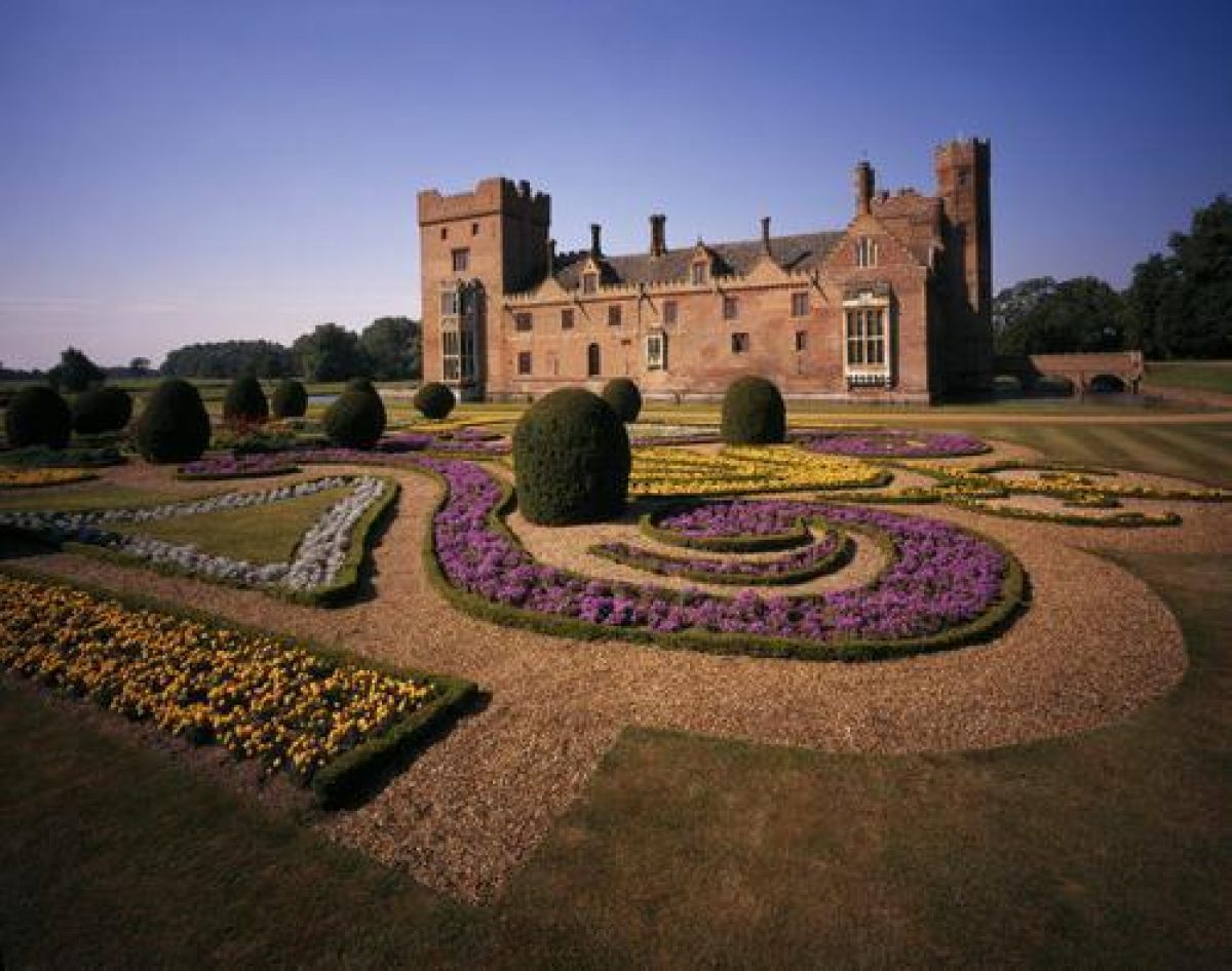
Oxburgh Hall (listed grade I) is a fortified country house built of red brick with stone dressings under a pantile roof. It is a square, moated building constructed as four wings arranged around an inner courtyard. The north-west front has a central three-storey C15 gatehouse with vaulted archway flanked by turrets and wings with C19 gothic crenellated facades. The north-east facade has a four-storey tower at the south-east corner and two crow-stepped attic gables. The south-west facade is decorated in a similar fashion to the north-east facade. The Hall was originally completed in 1482 by the Bedingfield family. In 1778 Sir Richard Bedingfield undertook major remodelling to three of the four wings and in 1835 the architects J C Buckler and A W N Pugin carried out refurbishments.
Approximately 100m to the north-east of the Hall stands the stable block and coach house (listed grade II). These are arranged as three blocks around an open-sided courtyard to the north-west and in contrast to the other buildings on the site are constructed of gault brick with slate roofs. The stables were originally constructed on this site early in the C19 but in 1887, Sir Henry Bedingfield, the seventh Baronet had them pulled down and the present buildings erected (UEA 1993). On the north side of the drive opposite the stables stands Stable Cottage, a two-storey cream brick and pantile building with leaded lights and decorative bargeboards. The north gable forms part of the boundary wall and is of red brick with a stepped gable.
GARDENS AND PLEASURE GROUNDS
The gardens and pleasure grounds lie to the south-east and north of the Hall. To the east is the French Parterre made of box scroll work and yew spheres filled with lavender. The Parterre was laid out for Sir Richard Bedingfield in c 1845 following a design from Dezalliers d'Argenville's La Thorie et la pratique de jardinage (1709). Beyond the Parterre to the east is a yew hedge and long herbaceous border, planted against the outer wall of the walled garden. To the south of the walled garden is a late C20 shrub area known as the Chelsea Garden which leads across a watercourse into My Lady's Wood, a woodland garden filled with box and yew and containing a small rustic summerhouse (late C20). This area was developed in the early C19 and further embellished in the early C20.
To the north of the Hall is the long terrace walk running from an arched brick gateway (listed grade II) c 70m to the north-east, along the face of the building, south-west to a small gate into the Oak Yard. Beyond the terrace to the north are lawns planted with mature trees of beech, cedar, and yew, and the Stable Bank (also laid to lawn with trees) to the north-east. Some 90m to the north-west of the moat, beyond the lawn, stands St Mary's Chapel (listed grade II*), a brick and ashlar private chapel built in 1838 and attributed to A W N Pugin. Around the Chapel, and mainly to the west of it, lies the pleasure ground or Wilderness planted with trees and spring bulbs and cut through by meandering paths. A lime avenue runs through the area towards a small rustic bridge (late C20). The Wilderness was laid out during the C19 and restored in the 1970s.
PARK
The park lies to the south of the Hall, beyond a brick ha-ha. The area immediately to the south and west is pasture with scattered trees, most of which lie to the west. The west section contains some very ancient oak trees and was labelled as the Oak Yard on an early C18 map (Map of the parish of Oxburgh, 1722), whilst the southern section contains earthworks which may be partly the remains of C16 formal garden features (UEA 1993). Beyond the pasture area to south and west the remainder of the park is under arable production with few surviving parkland trees. Perimeter belts survive to the east and south and these date from the mid C19 when the landscape park was created. To the south-west of the Hall is a further block of woodland known as Home Covert. This area is currently (1999) being restored to hardwoods from conifer plantations and it contains a long raised walk lined with beech. Home Covert is an older piece of woodland, having been in existence since at least 1801 (estate map).
KITCHEN GARDEN
The walled kitchen and flower garden (listed grade II) lies c 70m to the north-east of the moat, beyond the French Parterre. It covers c 0.5ha and is surrounded by a red-brick crenellated wall with four square towers, three along the north-east face and the fourth in the north-west corner. One tower serves as an entrance porch and another as a dovecote and all are decorated with stepped crenellations. The garden is divided into two compartments, the largest of which has been newly planted as a mixed orchard (1999). The small northern compartment is used for vegetable production with a range of old garden stores and modern glasshouses. The walled garden was constructed in c 1835 by J C Buckler for Sir Richard Bedingfield. It is thought to stand on the site of a much earlier kitchen garden which was originally built to accompany the early hall (UEA 1993).
REFERENCES
Dezalliers d'Argenville, La Thorie et la pratique de jardinage (1709)
Country Life, 1 (22 May 1897), pp 548-50; 13 (11 April 1903), pp 470-7; 66 (17 August 1929), pp 224-32; 167 (26 June 1980), pp 1480-2
N Pevsner, The Buildings of England: North-west and South Norfolk (1962), pp 282-3
Oxburgh Hall, Norfolk, guidebook, (National Trust 1978)
G S Thomas, Gardens of the National Trust (1979), pp 191-2
Oxburgh: A report on the history of the park and gardens, (University of East Anglia report 1993)
Maps
The Manor of Oxburgh, no date (around 1650-1722), (National Trust Collection)
Map of the Parish of Oxburgh, 1722 (National Trust Collection)
W Faden, A new topographical map of the county of Norfolk, 1797 (Norfolk Record Office)
A Bryant, Map of the county of Norfolk, 1826 (Norfolk Record Office)
Tithe map for Oxborough parish, 1845-6 (864), (Norfolk Record Office)
OS 6" to 1 mile: 1st edition published 1891; 2nd edition published 1907; 1950 edition
OS 25" to 1 mile: 1st edition published 1883; 2nd edition published 1905
Archival items
Sale particulars, 1951 (MC 288/7, 697x9), (Norfolk Record Office)
The main body of archives concerning Oxburgh Hall are held in a private collection.
Description written: March 1999
Edited: March 2001
- Visitor Access, Directions & Contacts
Telephone
441366328258Access contact details
http://www.nationaltrust.org.uk/place-pages/254/pages/opening-times-calendar
Owners
The National Trust
Heelis, Kemble Drive, Swindon, SN2 2NA
- History
The following is from the Register of Parks and Gardens of Special Historic Interest. For the most up-to-date Register entry, please visit the The National Heritage List for England (NHLE):
www.historicengland.org.uk/listing/the-list
HISTORIC DEVELOPMENT
The building of Oxburgh Hall, a fortified manor house, was started by the Bedingfield family in 1476 and completed by Sir Edmund Bedingfield in 1482. His son, also Edmund, entertained King Henry VII and Queen Elizabeth of York in 1497, demonstrating the importance of the family both locally and nationally. Earthwork remains suggest that gardens were laid out by the mid-16th century. In 1646, during the Civil War, Sir Henry Bedingfield was confined to the Tower of London and Oxburgh was pillaged and partly fired (Country Life 1903). In the later years of the 17th century, following the Reformation, Sir Henry was made a baronet and work began on repairing the Hall and grounds, including the construction of a walled kitchen garden and the laying out of Walks to the south of the Hall (University of East Anglia 1993). At the end of the 18th century, Sir Richard, fourth Baronet, demolished part of the Hall and rebuilt the south-east and south-west facades which looked out over the new, more natural landscape he created at that time. The fifth Baronet, Sir Richard II made small alterations to the gardens but for much of the first half of the 19th century the Hall was leased. When however it was inherited by Sir Henry Richard Paston-Bedingfield, sixth Baronet in 1829, the family retook possession and made substantial changes to both the Hall and the estate. The architects J C Buckler and A W N Pugin were commissioned in about 1835 to restore the Hall. They also added a stable block and a chapel and rebuilt the walled kitchen garden and flower garden. A French Parterre was laid out east of the moat, the pleasure ground was created west of the new chapel, and a landscape park laid out to the south and west. After 1902, under the eighth Baronet further alterations were made to the layout of the drives, with the addition of a new east lodge, and to the planting in the park (UEA 1993). After almost 500 years of continuous ownership, the Bedingfields sold the estate in 1951 to the Ashdale Property and Estate company who split the estate into portions which were offered for sale individually. The Dowager Lady Bedingfield, together with two other family members, bought back the Hall and immediate grounds which were given to the National Trust in 1952, in whose ownership it remains (1999). The Trust have subsequently purchased Home Covert to the south-west of the Hall.
- Associated People
- Features & Designations
Designations
The National Heritage List for England: Register of Parks and Gardens
- Reference: GD2012
- Grade: II
Features
- Manor House (featured building)
- Description: The building of Oxburgh Hall, a fortified manor house, was started by the Bedingfield family in 1476 and completed by Sir Edmund Bedingfield in 1482.
- Earliest Date:
- Latest Date:
- Parterre
- Orchard
- Boundary Wall
- Description: The site is bounded to the north by a red-brick turreted wall.
- Plantation
- Description: To the east is a long plantation, Park Belt.
- Gardens
- Parkland
- Kitchen Garden
- Key Information
Type
Park
Purpose
Ornamental
Principal Building
Domestic / Residential
Survival
Extant
Hectares
121
Open to the public
Yes
Civil Parish
Oxborough
- References
References
- {English Heritage Register of Parks and Gardens of Special Historic Interest}, (Swindon: English Heritage, 2008) [on CD-ROM] Historic England Register of Parks and Gardens of Special Historic Interest
- Thomas, G. S., {Gardens of the National Trust} ([London]: Weidenfeld and Nicolson, 1979), pp. 191-2 Gardens of the National Trust (1979)
- Pevsner, N., {The Buildings of England: North-west and South Norfolk} (Harmondsworth: Penguin, 1962), p. 282-3 The Buildings of England: North-west and South Norfolk
- Taigel, Anthea {Oxburgh: A report on the history of the park and gardens (UEA)} (1993) Oxburgh: A report on the history of the park and gardens (UEA)