
Introduction
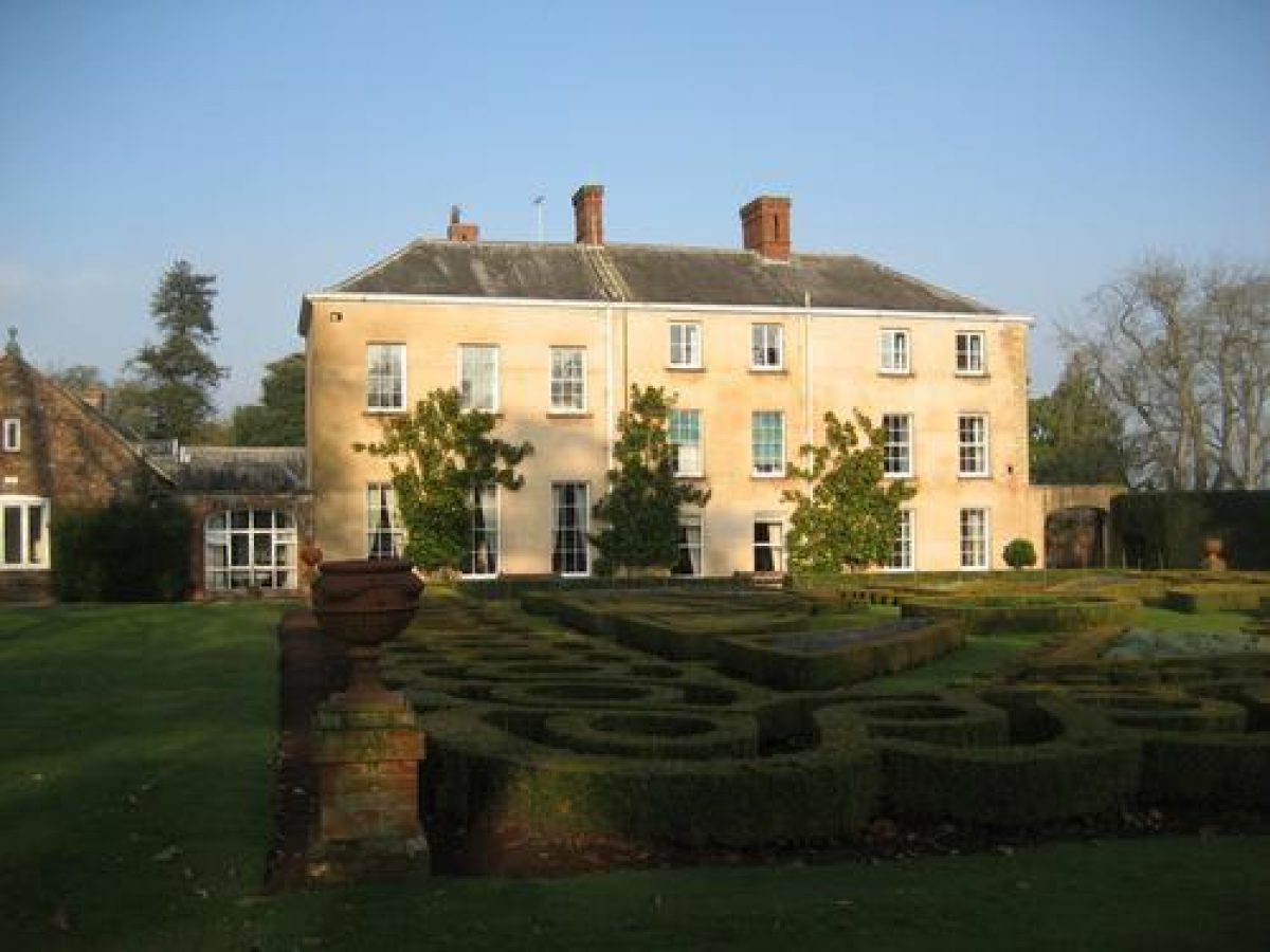
Nynehead Court is a remarkable early example of the classical style in Somerset, with a dated internal keystone of 1675, marking the enlargement and rebuilding of the house with earlier Tudor doorways and walls. The house is built on a courtyard plan with rendered rubble walls grooved to represent ashlar. Nynehead Court has an ornamental 19th-century parterre and an extensive 18th-century landscape park to the south, south-east and south-west of the house, covering approximately 119 hectares. The Estate is composed of lawns, parkland, a knot garden, a pinetum and many venerable and interesting trees.
Terrain
Nynehead Court is situated on a south- and south-west-facing slope which drops down to the River Tone. The land to the south of the river is relatively level.
The following is from the Register of Parks and Gardens of Special Historic Interest. For the most up-to-date Register entry, please visit The National Heritage List for England (NHLE):
Location, Area, Boundaries, Landform and Setting
Nynehead Court is situated c 1.5km north of Wellington, to the west of Nynehead Road and immediately north-west of the parish church of All Saints. The c 119ha site comprises c 7ha of formal gardens, walled gardens, and informal pleasure grounds, and c 112ha of parkland. To the east the site is bounded by Nynehead Road, from which it is separated by a variety of fences, hedges, and walls. To the north-east the site adjoins All Saints' Church, and to the north-east of the Court, Nynehead Court Cottages.
The northern boundary is marked by a stone wall which separates the park from a minor road which continues Nynehead Road north-west towards Chipley. To the west the site adjoins agricultural land, while the southern boundary is marked by the remains of the Grand Western Canal. Nynehead Court is situated on a south- and south-west-facing slope which drops down to the River Tone. The land to the south of the river is relatively level, allowing wide views towards Wellington, where the tower of the parish church serves as an eyecatcher, and beyond to the Blackdown Hills and the Wellington Monument.
Entrances and Approaches
Since 2002, Nynehead Court is approached from Nynehead Road to the east at a point immediately north-east of the parish church. The entrance is marked by a pair of square piers constructed in rubble stone with ashlar dressings under flat stone caps (rebuilt late C20), which are flanked by stone walls. The entrance leads to a tarmac drive which extends c 40m south-west between grass banks planted with specimen trees.
The drive divides, with one branch leading south-east to the church, and another turning sharply north and west to pass round a walled enclosure below the north façade of the house, to reach the stable yard, now used as a car park, to the north of the house. The drive is separated from the walled court to the east of the house by an C18 or C19 rubble-stone wall in which a simple opening allows access to a carriage turn. Within the court a central circular lawn is planted with a mature lime, while to the south-east a grass bank ascends to the level of the churchyard which is here open to the gardens.
The north side of the court is enclosed by a high brick wall (listed grade II), probably of C18 origin. A large rectangular recess in this wall, now paved and approached from the level of the court by a broad flight of stone steps, is the remains of a conservatory or greenhouse, probably constructed in the early C19. A bothy (restored 2002) survives on the outer face of this wall, accessed from the stable yard. An arch in the wall at the north-east corner of the house links through to the stable yard. Nynehead Court was originally approached from the south, as shown on the Tithe map of 1839, with a drive passing through the pleasure grounds to approach a carriage turn below the east façade of the house. The present access appears to have been developed in the mid C19 when the parterre was planted below the south façade, and the south drive was modified, taking it round the west and north sides of the pleasure grounds.
The south drive survives in part as a track and footpath (2002). The drive enters the south-east tip of the site from Nynehead Road at a point c 190m north of its junction with the A38, Taunton Road. The entrance is marked by a pair of early C19 stone piers (listed grade II) which support metal gates, and leads to a drive which extends c 250m north and north-west through a plantation, passing to the east of an early C19 stone lodge. Sweeping north-west, the drive passes beneath a stone bridge carrying the Great Western Railway which was constructed in 1844 (Pevsner 1958) and continues for c 50m north-west through a cutting lined with stone walls (listed grade II) before passing beneath the former aqueduct built c 1830 to carry the Grand Western Canal over the drive. Beyond the aqueduct the drive passes between a further pair of stone piers to emerge into the park.
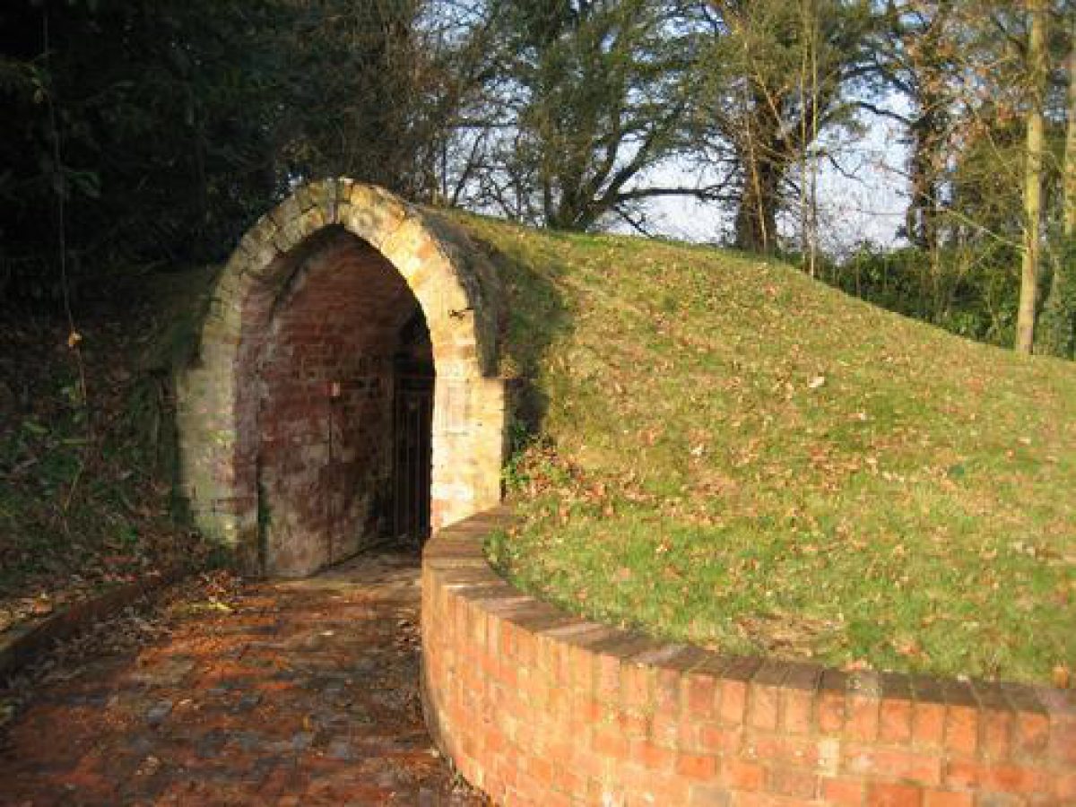
The drive, now reduced to a track, sweeps c 800m north-west, dropping gently down to cross the River Tone on the bridge built by Thomas Lee in 1817. Beyond the river the course of the drive sweeps north and north-west round the shoulder of higher ground on which the house and pleasure grounds are situated. The drive passes through a C19 entrance comprising stone piers with pyramid caps c 130m west of the house to enter the pleasure grounds. Crossing a drive leading west from the house to Court Farm and the kitchen garden, it continues to sweep north and north-east to reach the north side of the stable yard to the north of the house. The stable court is entered through a gateway flanked by rusticated stone piers, adjacent to which is the late C18 or early C19 icehouse.
While the arrangement of the drive to the south-east of the River Tone remains substantially as shown on the Tithe map (1839), its course to the north of the river was altered significantly during the second half of the C19. Prior to c 1850 the bridge formed the effective entrance to the pleasure grounds, with the drive leading directly north from the bridge through a thin sleeve of pleasure ground and continuing through the pleasure grounds to emerge into the east court at the south-east corner of the house. The mid or late C19 drive sweeping round the west side of the pleasure grounds was developed from a track which is shown on the Tithe map (1839) leading north-west from the bridge. A similar track led north-east from the bridge to join the southern end of a track which survives (2002) on the eastern boundary of the pleasure grounds. The avenue shown lining the drive to the south-east of the River Tone on the Tithe map (1839) and the 1905 OS map does not survive.
Principal Building
Nynehead Court (listed grade II*) stands on a terrace towards the north-east corner of the site immediately north-west of the medieval parish church of All Saints (listed grade I). Constructed in partly rendered rubble stone, the Court comprises two and three storeys under pitched and hipped slate roofs and is predominantly lit by sash windows and attic dormers. The house is built around a central courtyard with kitchens and service quarters to the north and north-east, and the principal apartments to the south and west. As originally constructed, the medieval hall is believed to have been situated to the east of the courtyard, with an entrance from the west. This structure was largely rebuilt in 1675 and extended to the west in the late C18. The south range was further altered in the early C19, presumably as part of a scheme of improvements undertaken by W A Sandford.
Gardens and Pleasure Grounds
The gardens and pleasure grounds are situated to the south and west of the house, with a formal parterre immediately below the south façade of the house, a walled pinetum to the south-east, and more informal areas of pleasure ground to the south and west of the parterre. The gardens and pleasure grounds are enclosed from the park to the south and west by C19 spiked metal fences.
A gravel walk leads from the east court to the gardens south of the house. The walk sweeps south-east through a yew tunnel which is backed to the north-east by a curved brick and rubble wall (listed grade II) connecting the south-east corner of the house and the tower of the parish church. Probably of C18 origin and altered in the C19, this wall screens the churchyard from the gardens, and has on the outer, churchyard side unusual semicircular buttresses thought to be bee holes. These were originally intended to provide wax for church candles.
To the west of the yew tunnel, a level lawn below the south façade of the house is laid out with an elaborate parterre comprising a series of geometrical box-edged beds radiating from a central circular bed and divided by grass paths. The outer edges of the parterre to the east, south, and west are marked by clipped box guilloche patterns, while to the south late C20 terracotta urns by Jim Keeling stand on low brick piers marking the central north to south axis of the parterre, and its south-east and south-west corners. The central axis of the parterre is projected southwards through an area of lawn by a late C20 avenue of Irish yews which leads to a seat overlooking the park, the town of Wellington, and the Blackdown Hills beyond.
To the east and west of this avenue mature specimen trees, including sweet chestnuts of some considerable age, appear to survive from an C18 or earlier formal scheme. One group of trees appears to extend in a southerly direction, perhaps corresponding to those shown flanking the south drive on the Tithe map (1839), while another group adjoins a mown grass path which sweeps north-west through an area of informal pleasure ground comprising lawn and scattered trees and shrubs to the south-west of the house. Returning east, this path enters a rectangular garden enclosed to the east, south, and west by clipped yew hedges and laid out on a terrace at the south-west corner of the house. To the north the garden is enclosed by a wall which supports a range of C19 timber-framed glasshouses (derelict 2002). A gravel walk extends from west to east through the garden, passing beneath a series of late C19 or early C20 metal rose arches, to reach a flight of steps descending to the parterre.
The gardens and pleasure grounds underwent significant alteration during the C19: the early C19 pleasure grounds were informal in character, incorporating mature trees from an earlier, formal layout. The area included within the pleasure grounds extended further south than the present park boundary, partly to accommodate the drive ascending from the bridge across the River Tone. It appears that the area of the pleasure grounds was slightly reduced in the mid C19 when the alignment of the drive was altered, and the parterre laid out beneath the south façade. Both the designer, and the date of planting, of the parterre remain unknown.
To the south-east of the house and immediately south of the churchyard a rectangular pinetum is enclosed by brick walls (listed grade II). This area is laid to grass and planted with specimen trees and shrubs, many being now mature and probably of late C19 origin. The garden is shown on the Tithe map (1839) as a productive garden and was probably constructed in the late C18 and altered in the mid C19.
Park
The park is situated principally to the north, west, and south of the house, with a further, detached area of park to the east of Nynehead Road. Today (2002) the park is in mixed agricultural use, with significant areas to the south of the house being in arable cultivation, while areas to the north remain predominantly pasture. The park retains scattered specimen trees although the number surviving is significantly reduced from those shown on the Tithe map (1839) and the 1905 OS map. To the north the park is enclosed by stone walls, while to the north-west a boundary plantation screens Lynch Cottage and the site of the C19 kennels.
The western boundary is generally open, allowing views to the agricultural landscape beyond, while to the south the course of the Grand Western Canal is marked by a strip of woodland, including, to the south-east, Long Copse which returns north-east to screen the park from Nynehead Road. The principal feature of the park landscape is the River Tone which flows from west to east c 350m south of the house, and which is crossed by a three-arched bridge constructed in sandstone ashlar. The bridge was designed and built in 1817 by Thomas Lee for W A Sandford, the design being exhibited at the Royal Academy in 1818.
To the east of the bridge, and south of the River Tone, a mixed plantation, Laurel Covert, controls views north from the south-east drive towards the house, and views south and south-east across the park from the pleasure grounds. This plantation corresponds to one shown on the Tithe map (1839). The small area of parkland to the east of Nynehead Road and c 350m east of the house is situated on rising ground visible from the east court and the eastern park. The ground, which remains as pasture (2002), rises east-north-east to a mixed plantation, Burrows. The configuration of park and plantation remains as shown on the Tithe map (1839).
The park appears to have assumed its present form as part of the scheme of improvements undertaken by W A Sandford in the early C19, probably developing an existing park of C18 or earlier origin. It remains substantially unchanged from the scheme recorded on the Tithe map (1839).
Kitchen Garden
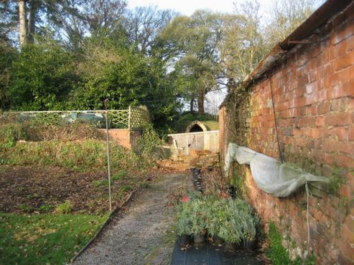
The kitchen garden is situated in the park c 350m west-south-west of the house, immediately adjacent to Court Farmhouse (listed grade II), and is approached from the house and pleasure grounds by a straight, partly tree-lined drive which corresponds to one existing in 1839 (Tithe map). The garden is rectangular on plan and enclosed by brick walls c 3m high surmounted by Ham stone coping (listed grade II). The garden is adjoined to the north-east by the farmhouse, a two-storey house constructed in rendered rubble stone under a thatched roof with dormer windows lighting the upper floor.
The farmhouse was originally built in the C17 and was incorporated into the scheme for the kitchen garden in the late C18. The present condition of the kitchen garden is unknown, but its plan appears to have been modified during the C19 (Tithe map, 1839; OS 1905). The glasshouses shown on the Tithe map adjacent to the north wall of the garden do not appear to survive (OS 1905); in the C19 the garden was used for the cultivation of exotics, including fifteen pineapple plants in three varieties, supplied by Dodds of Salisbury in 1837 (Bond 1998).
In 1839 (Tithe map), and 1905 (OS), areas of orchard existed to the north of the house and stable court, and to the east of the pleasure grounds. These areas today (2002) merge with the adjacent park, but retain some mature standard fruit trees.
Maps
- Tithe map for Nynehead parish, 1839 (M5301/1), (Somerset Record Office)
- OS 6" to 1 mile: 2nd edition published 1905; 1938 edition
Archival items
- Aerial photograph of Nynehead Court from the west, 1953 (Cambridge University Collection) [reproduced in Binney and Hills 1977)
Survey by Somerset Gardens Trust - 1998-1999
The history has already been outlined in the Taunton Deane Research Project, Phase 2, September 1994.
Continuing work
Work in the garden continues with the Ice House has been restored, with a grant from the Taunton Deane Council and AGS.
The Orangery site, which has one wall remaining, now consists of terraced steps up to a grassed area (the turf being only 3" deep) and a paved area nearer the house. It was probably built after 1792 judging by the brick work, and was used for Church services in 1869. The framework was still in position in 1946, with the tiled floor, but no glass.
The Apple Orchard, which was planted as a war effort in the 1939-45 war is now being replanted as a Pinetum. A grant was obtained in 1993 for the trees to be treated by the tree surgeon Adrian Morris. The present trees include Scots Pine, Corsican Pines, a Wellingtonia, Cedars of Lebanon and a Douglas Fir.
In 1993 three Magnolia grandiflora were planted on the South wall of the house to replace the existing one which had been there for 130-140 years but had to be removed in order to repair the foundations of the house. A heating channel was found under the roots of the old Magnolias. The replacements were the largest available plants, by order of English Heritage, and came from Holland.
A Yew allee was planted in 2000 AD prolonging the central axis of the knot garden into the park.
The Knot Garden with its guilloche pattern is being lovingly maintained. The square where it exists is shown on the 1885 map but it was
Glasshouses
The west end of the glasshouse beyond the west end of the house was rebuilt in the 1970's with unseasoned timber and is now completely rotten. The east end is original and in reasonable condition.
Trees
- The Tulip Tree in middle of front drive. No tulip tree can be seen in 1792 drawing. In 1892 PC the tulip tree looked not much less than 100 years old.
- Black Mulberry
- Chestnuts. Castanea sativa. Thought to be 200 years + old. November 1834: Account showing credit for 10 bushels Chestnut seed (£2.10.00) allowed off a bill of £6.40 from James Veitch, Killerton. Chestnuts must have been in full bearing. 1836: Hammond & Stephens, nurserymen of Taunton, paid £1.1.0 for 3 bushels of Chestnut seed.
- 1835: cherry trees bought in for £2.7s.6d. Dec 1836: Webber & Peirse of Crewkerne supplied 1 large Magnolia grandiflora for £3.12.6 (normally 5 shillings at that time).
- Luccombe Oak planted 1775-1800. Ref. R Whittaker, Notes on Nynehead Court 1979.
- Ginkgo: 1754 in this country but not in catalogues till 1775-1800.
- Historical Interest: Catalogue of Trees 1896 (ref. 3503 DD/SF). For sale Jan 30th 1896 at Squirrel Hotel, Wellington, from estate 5 …… from rear Kitchen Garden. Survey and valuation of Oaks n.d. 333 oaks cost £148.1.0 in Carkars wood. 1838: James Veitch supplied fruit trees and 5 vines ref: James Bond, Somerset Parks and Gardens, PP 107, 115, 121. New formal gardens continued to be made. 16 Pineapple plants in 3 varieties from Dodds of Salisbury, 5 shillings.
- 1981: Nine trees given by the Director and Individual Residents of Nynehead Court Nursing Home (Year of the Tree).
- 1977: Queen Elizabeth II Jubilee - Scarlet Oak (Quercus coccinea) planted. Fee paid by BBC for broadcast.
- Mid-19th-century formal gardens incorporating elements from earlier gardens, together with 18th-century walled gardens and a park of 18th-century origin which was further developed in the early 19th century.
Description written: December 2002
Edited: October 2021
- Visitor Access, Directions & Contacts
- History
The following is from the Register of Parks and Gardens of Special Historic Interest. For the most up-to-date Register entry, please visit The National Heritage List for England (NHLE):
In the medieval period, Nynehead was held by the Wyke family, who were responsible for building the house which remains at the core of the present Nynehead Court.
16th - 17th Century
In 1590 the estate was sold to Martin Sandford, whose descendants remained in possession of Nynehead until the 1920s. In 1675 the late medieval hall house was largely rebuilt and considerably extended, while in the late 18th century further additions were made.
19th Century
In 1810, W A Sandford commissioned Thomas Lee to build a new bridge across the River Tone in the park, as part of a new approach to the house. The landscape developed by W A Sandford in the early 19th century is recorded on the Tithe map (1839).
In 1827, plans were brought forward to extend the Grand Western Canal from Loudwell to Taunton, passing along the southern boundary of the park and crossing the new drive on an aqueduct at the south-east tip of the park. Opened in 1838, this section of canal incorporated eight vertical lifts and one inclined plane making it expensive to run. Following the sale of the canal to the Bristol & Exeter Railway in 1863, the canal was closed to traffic and fell into disuse (Rolt 1969).
In the mid-19th century the Great Western Railway line was constructed parallel to the old canal, with a further bridge built in 1844 crossing the drive at the south-east tip of the park. At about the same time, a formal parterre appears to have been laid out to the south of the house, necessitating the removal of that section of the south drive which led through the pleasure grounds to the carriage court east of the house.
20th Century
The south drive remained in use however into the early 20th century, with a branch sweeping round the west and north sides of the house serving as an extended approach (OS 1905).
The Nynehead Court estate was divided and sold on several occasions in the mid-20th century, the Court becoming a residential nursing home in 1949. Today (2002) the site remains in divided ownership, with the Court continuing in institutional use.
Trees of Historical Interest
- Tulip Tree in middle of front drive. No tulip tree in 1792 drawing. In 1892 PG the tulip tree looked not much less than 100 years old.
- Black Mulberry
- Chestnuts Castanea sativa, thought to be 200 years + old. November 1834. Account showing credit for 10 bushels Chestnut seed (£2.10.00) allowed off a bill of £6.40 from James Veitch, Killerton. Chestnuts must have been in full bearing.
- 1836 Hammond & Stephens, nurserymen of Taunton, paid £1.1.0 for 3 bushels of Chestnut seed.
- 1835 Cherry trees bought for £2.7s.6d. Dec 1836 Webber & Peirse of Crewkerne supplied 1 large Magnolia grandiflora for £3.12.6 (normally 5 shillings at that time).
- Luccombe Oak planted 1775-1800. Rev R Whittaker Notes on Nynehead Court 1979. Ginkgo 1754 in this country but not in catalogues till 1775-1800.
- Catalogue of Trees. 1896. (ref 3503 DD/SF). For sale Jan 30th 1896
Period
18th Century (1701 to 1800)
- Associated People
- Features & Designations
Designations
The National Heritage List for England: Register of Parks and Gardens
- Reference: GD1508
- Grade: II*
Plant Environment
- Environment
- Walled Garden
Style
- Formal
- Informal
- Picturesque
Features
- Parterre
- Earliest Date:
- Latest Date:
- Bee Bole
- 3. Good condition Brick
- Description: Fronts now filled in under Yew arch
- Icehouse
- Description: Restored late 20th century with a grant from Taunton Deane Council and AGS.
- Croquet Lawn
- House (featured building)
- Description: The late-medieval house was largely re-built in 1675, and added to in the late-18th century.
- Earliest Date:
- Latest Date:
- Canal
- Description: The southern boundary is marked by the remains of the Grand Western Canal.
- River
- Description: The River Tone
- Boundary Wall, Parkland
- Bridge
- Description: Now outside the boundary over River Tone
- Coach House
- Remnants
- Description: Previously behind Orangery
- Drive
- Tarmac
- Fence
- Iron railings around parkland
- Arch
- Good condition
- Description: Either side of main entrance. Five around Mulberry Garden
- Bird Bath
- Description: Reconstituted Stone
- Gate Piers
- Stone Blocks
- Description: At back drive near Ice House. Hinges on one side. No gate. At front entrance ends of walls strengthened but no piers (upper gate hinge each side)
- Greenhouse
- East end - reasonable West end rotten
- Description: The west end of the glasshouse beyond the west end of the house was rebuilt in the 1970's with unseasoned timber. The east end is original.
- Ironwork
- Description: Park fencing. Hooped arches.
- Patio, Paving
- Description: Made on site of old Orangery
- Steps, Stable
- Original wood and iron bars. 20th century breeze block & plank
- Description: 1. Old stables with looseboxes. 2. 20th century stables
- Summerhouse
- Good condition. Wood
- Description: Erected in 1993, donated by residents
- Tunnel arbour
- Yew
- Wall
- Reasonable condition
- Description: 1 side wall of old Orangery and 2 end walls. Wall around arboretum and in back courtyard
- Finial
- Stone
- Description: On old servants' wing facing south
- Garden Seat
- 15 wood
- Urn
- 4 terracotta and fruit swags and 2 smaller
- Description: 1 being mended, broken in attempted burglary; 3 pedestals and 2 urns at top of old Orangery steps. 3 stone urns in front of East front entrance. 1 smaller urn on corner of steps possibly 19th century made in Weston super Mare at brickworks.
- Water Tank
- Old water tank near boiler house with outlet to latter in case of fire
- Alley
- Description: New Yew planting beyond knot garden in 2000 AD prolonging the central axis of the knot garden into the park
- Arboretum, Bedding
- Description: New planting
- Espalier
- Description: Fruit in Courtyard behind boiler house
- Hedge
- Description: Yew leading to Church. Box.
- Herb garden
- Description: In walled garden N of Mulberry
- Orchard
- Description: Planted in 1939-45 war. Keeping some of old apple trees. Replanted as a Pinetum. A grant was obtained in 1993 for the trees to be treated by a tree surgeon. Trees include Scots Pine, Corsican Pines, a Wellingtonia, Cedars of Lebanon and a Douglas Fir.
- Shrub Border, Walled Garden, Vista, Pinetum
- Description: 2 Walled Gardens. Pinetum replacing part of orchard.
- Wilderness
- Description: By back drive
- Fountain
- No longer
- Description: Pipes in existence feeding fountain originally in centre of knot garden
- River
- Description: Now outside boundary
- Knot garden
- Description: The knot garden with its Guilloche pattern is being lovingly maintained. The square where it exists is shown on the 1885 map but it was
- Orangery
- Description: The Orangery site which has one wall remaining now consists of terraced steps up to a grassed area (the turf being only 3" deep), and a paved area nearer the house. It was probably built after 1792, judging by the brick work, and was used for church services in 1869. The framework was still in position in 1946, with the tiled floor, but no glass.
- Trees
- Railings
- Description: Around Park.
- Herbaceous Border
- Kitchen Garden
- Description: Being converted to herb garden.
- Walkway
- Well
- Two
- Description: 1 beside old Coach House. 2 in internal courtyard covered over.
- Key Information
Type
Garden
Purpose
Ornamental
Plant Environment
Environment
Principal Building
Domestic / Residential
Period
18th Century (1701 to 1800)
Survival
Extant
Hectares
119
Civil Parish
Nynehead
- References
References
- {English Heritage Register of Parks and Gardens of Special Historic Interest}, (Swindon: English Heritage, 2008) [on CD-ROM] Historic England Register of Parks and Gardens of Special Historic Interest
- Bond, J., {Somerset Parks and Gardens} (Tiverton: Somerset Books, 1998), pp. 107, 115, 121-2 Somerset Parks and Gardens
- Pevsner, N., {The Buildings of England: South and West Somerset} (Harmondsworth: Penguin, 1958), p. 265 The Buildings of England: South and West Somerset
- Nynehead and District Local History Society {The book of Nynehead : a village on the River Tone} (Tiverton: Halsgrove Press, 2003) 38-58 The book of Nynehead : a village on the River Tone
- Sanford files, DD/SF Somerset Record Office
- Ruth Whittaker 1979 Notes on the History of Nynehead Court
- Binney, M, and Hills, A., (1977), p 22 Elysian Gardens
- Rolt, L, T, C., (1969), pp 127-8, 139, 142, 145 Navigable Waterways
Contributors
Alec Reed, Former Head Gardener and his Assistant