Introduction
Newton Park features landscaped pleasure grounds, set within a park of around 120 hectares.
An C18 park, laid out by Lancelot Brown with later advice from Humphry Repton, around a country house, now used as a college of higher education.
Terrain
Generally rising ground
The following is from the Register of Parks and Gardens of Special Historic Interest. For the most up-to-date Register entry, please visit The National Heritage List for England (NHLE):
Location, Area, Boundaries, Landform and Setting
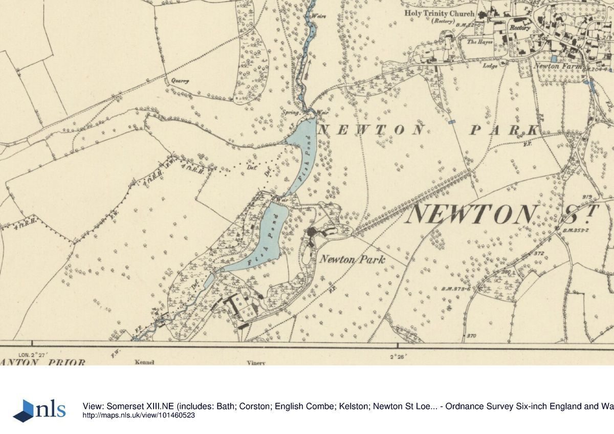
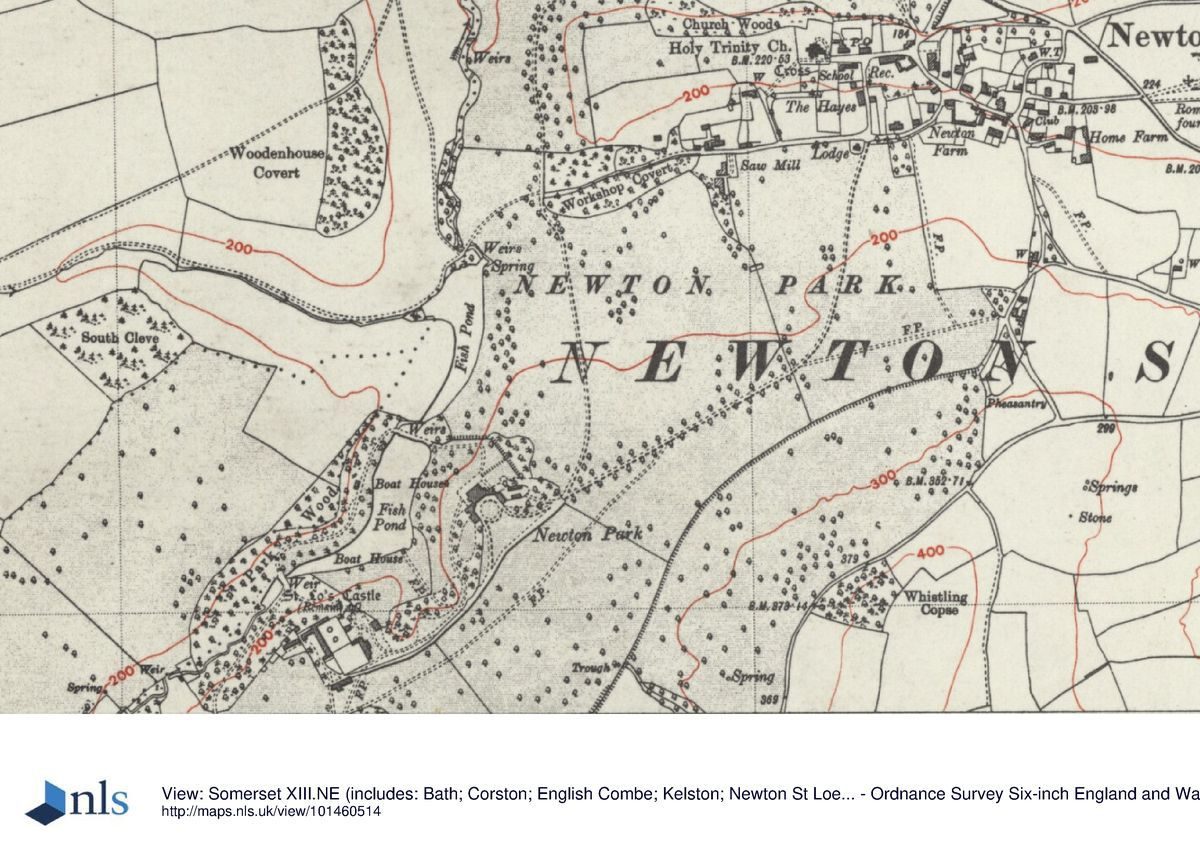
Newton Park (120ha) is situated c 5km west of the centre of Bath on generally rising ground south of the main A4, Bath to Bristol road and the Avon Valley, between the villages of Corston and Newton St Loe. The northern boundary is formed by the A39, Bath to Shepton Mallet road between Corston and the junction with the A4, and the eastern boundary by minor roads and the village of Newton St Loe. The southern and western boundaries are less well-defined being marked by hedge and fence lines, generally at the summit of the views from the park. The central north/south axis of the park rises gently to the south but is generally flat. Parallel to the central axis, c 100m to the west, is the incised but flat-bottomed valley of Corston Brook which is joined by the valley of a stream from the west at the Lower Lake, 300m north of the house. To the east the land rises smoothly to a ridge. The land to the west rises more steeply and is more undulating around the valley of the watercourse. Despite a proliferation of buildings erected for education use in the central area the park retains its pastoral appearance.
Entrances and Approaches
The main drive (c 1760s) from the north enters the park through an ornamental gateway next to a lodge (c 1902) 1.2km north-north-east of the house on the A39 road, 500m east of Corston village. North of this entrance is a disused 100m section of a drive cut through woodland to join the Bath to Bristol road, marked by stone gate piers, as recommended by Humphry Repton (1797). The drive heads 500m in a south-westerly direction across parkland with mature trees and clumps, and then turns south for 700m to run above, and parallel to the valley of Corston Brook to the west. It takes on a wooded character where it passes west of Workshop Covert, with views to the west over the valley to woodland beyond, and of the planting around the lower of the two lakes. The drive crosses more open parkland before emerging into the college campus, finally turning west to approach the house from the east. A second drive runs south and south-west from Newton St Loe village. It enters the park through a gateway (early-mid C19, listed grade II) next to a single-storey lodge (mid-late C19, listed grade II) 800m to the north-east of the house. The drive runs through fairly level and open parkland, its south-west half being flanked on either side by a replanted avenue of lime trees (1990s) on the line of an avenue shown on Hinde's survey (1763), and joins the north drive at the entrance to the college campus 100m north-east of the house.
Principal Building
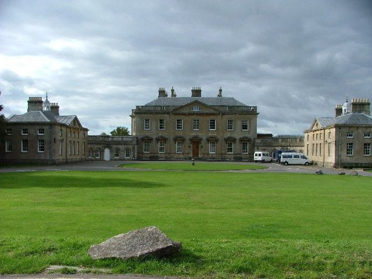
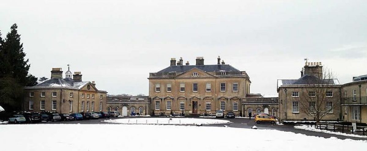
Newton Park (listed grade I) is the administrative centre and music rooms of Bath Spa University College and a former country house, built 1761-5 by Stiff Leadbetter for Joseph Langton. It occupies a position in the centre of the park, overlooking the Upper Lake to the west and Lower Lake to the north and with views to the south-east of parkland rising to a tree-lined ridge c 500m away. The house is constructed of Bath stone ashlar with a hipped and mansard slate roof behind a balustraded parapet. The central block has two storeys on a basement with attics in dormers and a central pediment. There are two projecting service wings, with central pediments, which curve forwards from the south-east front. The west wing has a clock in the tympanum and the east a compass, while both have octagonal bell turrets surmounted by ball finials and a windvane. The north-west and south-west elevations of the central block are similar to the south-east front but have full-height canted bays to the centre and pediments over the central windows only. Pevsner (1958) described the house as 'one of the finest country mansions of the C18 in Somerset'.
Gardens and Pleasure Grounds
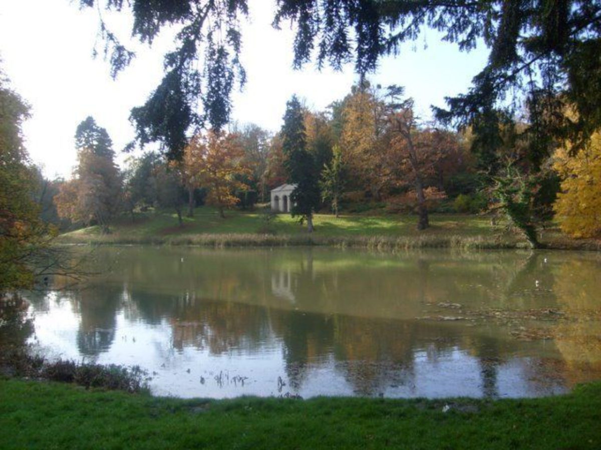
The pleasure grounds of c 2.5ha are located principally around the Upper Lake, 100m to the west of the house. This is the second of three lakes separated by dams, weirs, and cascades made by Lancelot Brown (1716-83) in 1761. The small former top lake is now completely silted and has partially reverted to scrub. The Upper Lake, restored 2000, is 250m long and c 75m wide and is partly visible from the principal rooms of the north-west, garden front of the house. There is a gravel circuit walk, ornamented with specimen trees and shrubs, providing a variety of views across the water to features of interest. These are the Garden Temple, restored 2000, backed by clipped yews, on the west bank 200m west of the house; the boathouse on the east bank 120m south-west of the house; and the Castle keep on its mound to the south, 200m south-west of the house. An C18 urn on a pedestal, restored 2000, is placed on the west bank, c 30m south of the Temple. The Lake circuit walk passes through the ornamental woodland of Park Wood to the south and west.
The eastern arm of the circuit connects with the ruins of St Loe's Castle (late C14/early C15, scheduled ancient monument, listed grade I), c 200m south-west of the house. A walled courtyard garden north-east of the stable block (C15-C19, listed grade II*) and 280m south-west of the house is entered through the Castle gatehouse and is laid out in a simple formal layout around rectangular lawns with two circular ponds and an open summerhouse built into the north-west wall. The garden circuit proceeds north-east from St Loe's Castle to approach the south-west front of the house alongside a lawn and shrubbery 50m south-west of the house. Between the east bank of Upper Lake and the house is a 100m steeply sloping grass bank with scattered mature oak trees dating from the Brown period. Recent research (Pearson Assocs 1993) indicates that Brown retained much of the pre-existing landscape in his reworking. As well as keeping most of the radiating avenues, he preserved the Castle gatehouse and keep as eyecatchers and incidents on the circuit walk, while demolishing the rest of the Castle's outbuildings and walls.
Park
The parkland of c 120ha runs southwards from the villages of Newton St Loe and Corston encompassing the valley of the Corston Brook, a tributary of the River Avon, on land which rises in all directions to the park's boundaries. The park consists of ten main sections: Old Park in the south; Upper Park to the south, south-east, and east of the house which is above Lower Park, south and south-east of the house; East Park to the north-east of the house; New Park beyond East Park to the north-east; Lodge Hill Park in the north, to the east of Corston Drive; Brook Park in the north, to the west of Corston Drive; Coombe Croft to the north-west of the house; West Park to the west of the house; and Lower Lake Park to the immediate north of the house and east of Lower Lake. An almost continuous but thin belt of trees marks the skyline above the Upper Park and Old Park. Old Park is undulating sloping pasture with two mature walnuts and two oak trees. Upper Park is a sloping hillside containing some mature trees and three gullies with dense scrub.
The west boundary with Lower Park is marked by the line of an C18 limestone ha-ha which partially survives. Lower Park is permanent pasture 100m to the south-east of the house, separated from the drive by an iron rail fence. This area contains old oak pollards and mature ornamental trees. West Park, to the west of Upper Lake, is C20 arable fields with a few surviving trees. The northern part of the park, including Brook Park and Lodge Hill Park, is pasture but has been used for arable in the recent past (late C20) and retains only a few scattered trees, except for the southern end of Lodge Hill Park which has retained permanent pasture on the slopes. This area contains many mature trees from the C18 including beech, lime, oak, sweet and horse chestnut. East Park and New Park contain the drive to Newton St Loe village. A plan by Pryce of 1789 provides the most complete record of Brown's parkland and shows the park planted with individual, groups, and clumps of trees.
The formal avenues, aligned on the Castle mount, appear to have been largely cleared around the new (1760s) mansion but remained intact beyond the house precincts. In 1796, Humphry Repton (1752-1818) was consulted and concerned himself with 'the further improvement of the beautiful scenery at Newton Park'. Despite his admission that 'it would appear presumptuous to suggest improvement in a spot which Mr Brown is supposed to have finished with great attention' (Repton 1797), he made recommendations for substantial alterations, including the replacement of a pair of entrance lodges with a single lodge, further thinning of the formal avenues, construction of a mausoleum as a focal point from the mansion, felling of conifers on the dams, construction of a third and larger lake, and realigning the approach drive to create a picturesque route from Corston across a bridge over the new lake. None of these proposals were implemented (Pearson Assocs 1993). The park, pleasure grounds, lakes, and woodlands have been undergoing continuous restoration since 1994 by the Duchy of Cornwall and Bath Spa University College with funding from the Countryside Commission, Countryside Stewardship, Forestry Commission, and the Heritage Lottery Fund.
Kitchen Garden
The late C18 kitchen garden lies c 500m south of the house and includes garden walls, greenhouses, and bothies, all generally intact, as well as beds and a few trained fruit trees. There are also some late C20 features including greenhouses and a central garden with circular pool. An external grass area with a few fruit trees and a grass paddock follows the west and south walls. Former external lean-to greenhouses have been lost.
Maps
[all reproduced in Pearson Assocs 1993]
- J Hinde, A survey of part of the manor of Newton, 1763
- P Pryce, Survey Plan of The Parish and manor of Newton St Loe, 1789
- Greenwood, County map of Somerset, 1822
- Tithe map for Newton St Loe parish, 1840
- OS 6" to 1 mile: 1930 edition
Illustrations
- S H Grimm, View of the castle keep, 1790 (reproduced in Pearson Assocs 1993, 1998)
- S H Grimm, View of Newton Place, 1790 (reproduced in Pearson Assocs 1993, 1998)
- S H Grimm, The Inner Gateway of the Old Mansion of the St Loes, 1790 (reproduced in Pearson Assocs 1993, 1998)
- J Collinson, View of Newton Park, c 1791 (in Collinson 1791)
Archival items
- H Repton, Red Book for Newton Park (1797) (in Rachel Mellon Collection, Oak Spring Garden Library, Virginia, USA)
- Avon Gardens Trust, Repton in Avon: booklet for Seminar (1989)
Description written: September 2002
Register Inspector: SH
Edited: October 2021
- Visitor Access, Directions & Contacts
Telephone
01225 875875Access contact details
The grounds are now a campus for Bath Spa University.
Directions
The site is on the A39, which can be reached from the A4.
Owners
Duchy of Cornwall
- History
The following is from the Register of Parks and Gardens of Special Historic Interest. For the most up-to-date Register entry, please visit The National Heritage List for England (NHLE):
14th Century
Newton Park was laid out on land containing the C14 keep and gateway of St Loe's Castle, a fortified medieval manor house, Elizabethan farm buildings, and various enclosed gardens. The manor was separated from the village of Newton St Loe by an enclosed park in the late C17.
18th Century
During the early C18 the estate was enlarged by the purchase of several neighbouring manors and land acquired through marriages. A survey of 1763 (Hinde) shows the positions of 'The New House' and 'The Old House' in a predominantly agricultural landscape divided into fields and with a few small woods, but with evidence of an extensive formal design in the form of seven avenues radiating from the core of the landscape around the mount of St Loe's Castle (Pearson Assocs 1998). The C18 house was built for Joseph Langton who commissioned Lancelot Brown in 1761 to improve the grounds.
The surviving C15 stable block was enlarged, in the style of the late C17, at about the time of Brown's involvement (ibid). Langton died in 1779 and was succeeded by his daughter Bridget, who in 1783 married William Gore, of Barrow Court, Avon (qv). Gore subsequently changed his name by royal assent to William Gore-Langton. Bridget died in 1793 but William continued to improve the grounds, calling in Humphry Repton in 1796.
19th - 20th Century
The C19 saw little change but further improvements were carried out between 1902 and 1914 by Algernon Gore-Langton. In 1914 Newton Park became the Countess Temple Hospital for wounded soldiers and was owned by Lord Temple until his death in 1940. The estate was purchased by the Duchy of Cornwall and the core built area was let on a long lease to Newton Park College, now Bath Spa University College (Pearson Assocs. 1993, 1998).
- Associated People
- Features & Designations
Designations
The National Heritage List for England: Register of Parks and Gardens
- Reference: GD1555
- Grade: II*
Features
- House (featured building)
- Latest Date:
- Key Information
Type
Park
Purpose
Ornamental
Principal Building
Education
Survival
Extant
Hectares
120
Open to the public
Yes
Civil Parish
Newton St. Loe
- References
References
- Harding, S and Lambert, D. {Parks and Gardens of Avon} (1994) pp 43-44; 83-84 Parks and Gardens of Avon
- Pevsner, N. {The Buildings of England: North Somerset and Bristol} (Harmondsworth: Penguin, 1958) pp 233-234 The Buildings of England: North Somerset and Bristol
- {English Heritage Register of Parks and Gardens of Special Historic Interest} (Swindon: English Heritage 2008) [on CD-ROM] Historic England Register of Parks and Gardens of Special Historic Interest
- Nicholas Pearson Associates {Newton Park Conservation Management Plan} (2010) Newton Park Conservation Management Plan
- Nicholas Pearson Associates {Newton Park Historic Landscape Survey} (1998) Newton Park Historic Landscape Survey
- Collinson, J., (1791) History and Antiquities of the County of Somerset
- Carter, G, et al., (1982), p 161 Humphry Repton
- Nicholas Pearson Associates, (1993) Newton Park Historic Survey and Restoration Plan
- Avon Gardens Trust Newsletter 22 (pp 11-32, 2000) Avon Gardens Trust Newsletter,
Contributors
Avon Gardens Trust