Introduction
Kelston Park has a terraced garden and landscape park of around 75 hectares.
An C18 park laid out by Lancelot Brown around a country house.
Terrain
The park is on a gently north-west to south-east sloping plateau which ends in steep slopes down to the Avon Valley to the south and east.The following is from the Register of Parks and Gardens of Special Historic Interest. For the most up-to-date Register entry, please visit The National Heritage List for England (NHLE):
Location, Area, Boundaries, Landform and Setting
Kelston Park (c 75ha) is located c 6.5km west of Bath in the last remaining area of open countryside between the Bath and Bristol conurbations. The parkland extends in a gentle sweep to the Avon Valley for c 1.2km along the south-west side of the A431, Upper Bristol Road, which forms its north-east boundary. The parkland descends a steep escarpment towards the River Avon to the south. The south-east and south-west boundaries run through the steep banks of Fir Wood, Summerhouse Wood, and Tennant's Wood. The western part of this boundary is marked by the Bristol to Bath Cycleway, formerly the London Midland Railway's route between the cities which closed to rail traffic in the 1970s. The short east boundary is marked by a fence line and small stream which runs south down an incised coombe to join the River Avon.
The north-west boundary is marked by a fence line connecting Tennant's Wood to Manor Farm and by the boundary walls of Kelston church and other properties in Kelston village c 800m to the north. The park is on a gently north-west to south-east sloping plateau which ends in steep slopes down to the Avon Valley to the south and east. To the north and north-east, beyond the A431, the land climbs steeply to Kelston Round Hill, a landmark hilltop crowned with a group of beech trees and visible for many miles around. To the north of Kelston Park is Kelston village which contains Manor Farm, close to the site of the former manor house, Kelston church, and a fine collection of historic vernacular buildings.
Entrances and Approaches
A small two-storey lodge in Italianate style, built by the Inigo-Jones family in 1857 and recently restored (1990s), marks the drive which enters the park from the Upper Bristol Road c 600m north-east of the house. The drive is unfenced and crosses open parkland to the house within a fenced enclosure, cattle grids protecting both openings. Laid out by Brown in the 1760s, the route is unusual for his design in taking the shortest distance between the house and the public highway. A pedestrian entrance leads from the village of Kelston, north of the church, and crosses the park in a straight line running c 800m from north-north-west to south-south-east to the house, approximately on the line of a former double avenue and on the low crown of the plateau (Pearson Assocs. 1994).
Principal Building
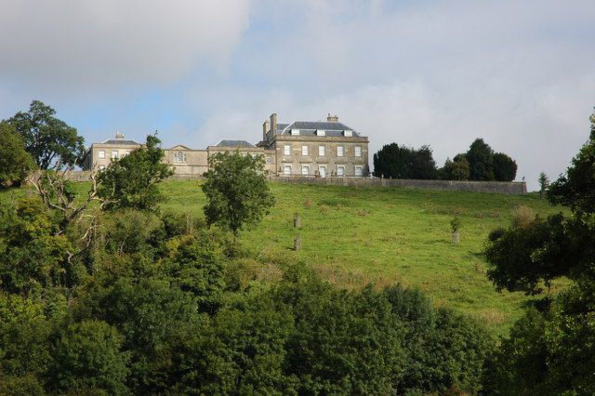
Kelston Park (1765-70, listed grade II*) is a former country house built of Bath stone with a hipped slate roof (now tarred) behind a parapet to a design by John Wood the younger for Sir Caesar Hawkins. It occupies a prominent position on the eastern end of a ridge, overlooking the city of Bath to the east and the valley of the River Avon to the south. The original 1760s mansion was a compact and restrained, almost severe design in the Classical style comprising two storeys, attic, and basement, the ground floor being reached from a terrace which has a rusticated retaining wall pierced by four arches. The house was later extended, Joseph Neeld erecting new buildings in 1828 in the yard which connects to the house with a two-storey corridor, forming an enclosed courtyard. In the mid C19 the central projecting porch of paired Tuscan columns was added and alterations to the windows were made by the Inigo-Jones family. To the west of the house, across an open yard, stands Wood's small coach house and stable block in the same style as the house (1760s, listed grade II*).
Gardens and Pleasure Grounds
Kelston Park house is separated from the park on the north side by a ha-ha (mid-late C19) which contains all the domestic buildings and the gardens to the south. On the south side of the house is a raised terrace (Inigo-Jones family, mid C19), enclosed by a balustrade with a flight of steps down to a broad, lower, dog-leg terrace with a stone parapet running 130m, continuing west beyond the length of the south façade of the house. The lower terrace has flower beds cut into the lawns. A ramped path, with a flanking wall, leads c 100m west from the lower terrace to Summerhouse Wood which contains a network of C18 paths and rides with C18 holm oaks, yew, and holly and exotic planting from the early C20, including Japanese maple and Persian ironwood. Just off a track in Summerhouse Wood is a circular red-brick icehouse (mid C18), reached via a limestone tunnel, c 400m west of the house. A stone-lined pool (mid C18) which lies above the icehouse is now dry.
Park
The undulating parkland occupies a plateau which slopes gently towards the Avon Valley to the south and east. The park is a wide sweep of land to the north and north-west of the house, subdivided into a number of fields. Internal field boundaries are of post and wire fencing, with continuous iron rails around the house and lodge. There are two small agricultural ponds and a larger one, formerly the Harrington reservoir, 800m north of the house, with two adjacent mature oaks. Tree cover is of three distinct types: open-grown parkland trees, clumps, and a mix of woody scrub and trees. Parkland specimens are mostly English oak, Turkey oak, sweet chestnut, walnut, and beech dating from c 1880 to 1900 with some beech and lime from c 1770. There are several clumps (c 1850) composed of beech, hornbeam, common lime, and oak with some sycamore and ash, with an understorey of hawthorn and game-cover plants, such as Butchers' Broom.
The north-east boundary of the park along the road has a margin thickly lined with woody scrub containing the regrowing stumps of lime trees dated to c 1780 (Pearson Assocs. 1994) and elm suckers. The steep slopes of the Avon Valley to the south are thickly wooded with the exceptions of a grassy hillside, called Old Park, c 500m west of the house in a gap between Tennant's Wood and Summerhouse Wood, and the turf banks below and to the south and east of the house. Both these grass slopes have specimen parkland trees. Old Park, which extends uphill from c 500m west of the house to c 700m north-west of the house, is a former deer park and rabbit warren of C16/C17 date and contains multiphase ornamental tree planting and the remains of a lime kiln. Tennant's Wood, c 700m west of the house, contains a walk linked to the park circuit and relic ornamental planting, but is mostly overgrown. Most of the timber in the rest of the parkland was felled in the inter-war period. During the mid to late C20 the park was in arable cultivation but was converted to pasture under a Countryside Stewardship agreement in 1995 which included the resumption of tree planting. The northern end of the park is divided into three fields down to grass containing the archaeological remains of extensive Elizabethan formal gardens associated with the former Manor House in Kelston village.
An estate plan (Thorp, 1744) shows a wide double avenue of trees leading from the old manor garden in a south-easterly direction towards the River Avon and a summerhouse, on the site of the house, commanding wide views of the Avon Valley. Another double avenue is shown crossing the main avenue at right angles, running from south-west to north-east across the northern third of the park, at that time a largely agricultural landscape. It is not possible to determine whether the avenues were part of the Elizabethan gardens or later additions. A field survey of the site found no trees surviving from this period, but two great elms which survived north and south of the present house until c 1970 may have formed the ends of the double avenue at the summerhouse (Pearson Assocs. 1994). No documentary evidence has been found to show how the layout of the gardens and park evolved during C17. The formal crossing avenues formed a backdrop to the northern boundary of the area of the park laid out by Brown and continued to be shown on plans until the late C19. The main avenue running south-south-east, on the route from the village to the house, bisected Brown's design, but was left intact. The remains of formal terraces and parterres associated with the old house were similarly untouched by Brown.
Kitchen Garden
An irregularly shaped, eight-sided stone-walled garden (late C18, listed grade II) with small farm buildings in a yard stands 50m to the north-west of the house. West of the farm buildings is an orchard, bounded variously by stone walls, hedges, and post and wire fences. The orchard contains a variety of early C20 apple and pear trees, a walnut, and a cherry tree.
Other Land
A track 850m north of Kelston Park leads 500m south-east through Sandpit Shrubbery and Shagbear Wood and runs for c 1km in an easterly direction before turning north-west on the Cotswold Way for 1km over Dean Hill to the ornamentally planted 218m summit of Kelston Round Hill. This route was an C18 ride from the park to take in the unbounded views available from the high ground to the north.
Maps
- Saxton, Map of the County of Somersetshire, 1575
- Speede, County of Somersetshire, 1610
- Thorp, Survey of the Harrington Estate, 1744 (private collection)
- Greenwood, County map of Somerset, 1822
- Estate Plan, c 1840 (reproduced in Pearson Assocs 1994)
- J Edgar and R Iles, Plan of the Harrington Manor and Gardens, 1981 (in Bristol Archaeology Research Group Journal 1981)
- OS Old Series, 1" to 1 mile, published 1817
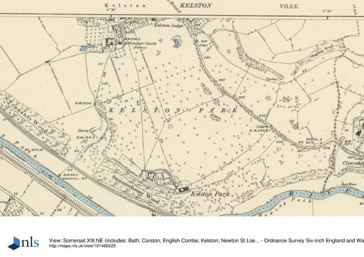
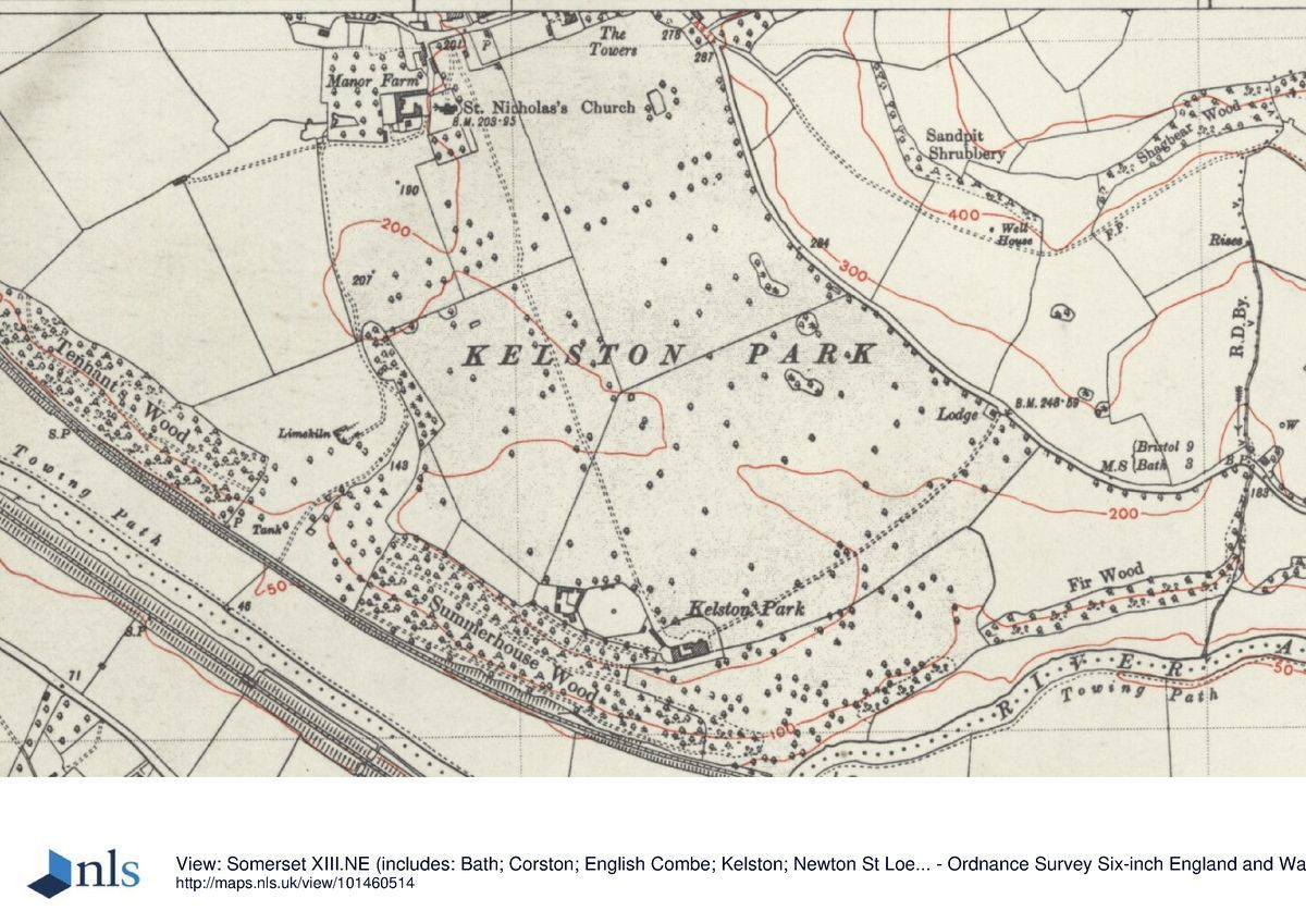
- OS 6" to 1 mile:
- 1933 edition
- 1938 edition
- OS 25" to 1 mile: 1st edition published 1888
Illustrations
- Bonner, Engraving of Kelston, 1788 (in Collinson 1791)
Description written: September 2002
Register Inspector: SH
Edited: September 2021
- Visitor Access, Directions & Contacts
Website
https://www.bath-preservation-trust.org.uk/planning-application/kelston-park-kelston-road-kelston-2/Access contact details
Kelston Park is a large public open space located in a residential area of north Keynsham. There is no charge for admission and the park is open throughout the year.
For more information visit the Bath and North East Somerset Council website.
Directions
Parking
On street parking on the roads surrounding the park. Please observe any local parking restrictions.
Disabled access
The park is flat and there is a good network of surfaced paths linking it to the surrounding streets.
Public Transport
Good bus services to Charlton Road.
Owners
Alliance of Religions and Conservation
Kelston Park, BA1 9AE
- History
The following is from the Register of Parks and Gardens of Special Historic Interest. For the most up-to-date Register entry, please visit The National Heritage List for England (NHLE):
13th - 16th Century
By the C13 Kelston was part of the possessions of Shaftesbury Abbey, Dorset. The Manor Farm barn and Old Park, formerly conygear, may date from this period. At the Dissolution the estate passed to Henry VIII's natural daughter, Ethelreda, through whom it passed by marriage to the Harrington family. Early maps of Somerset (Saxton, 1575; Speede, 1610) show the village of Kelweston but no manor house or park. Nevertheless, some time between 1567 and 1574, John Harrington began building a house close to the church. The house was finished by his son, Sir John, a courtier, poet, and godson of the Queen, and was intended to be one of the grandest houses in the county. Of the formerly numerous outbuildings, two remain, one of which has become the village hall.
17th Century
During the late C17 and early C18 the Harrington family became progressively impoverished and the Kelston estate was sold in 1759 to Sir Caesar Hawkins, a leading surgeon, for £1600. Hawkins created a new mansion (1765-70) and landscape (1767-8), locating the house on the site of a summerhouse on the lip of the southern scarp to exploit the views, and demolished the old manor house.
18th - 19th Century
Lancelot Brown (1716-83) was employed by Hawkins to landscape the park around the mansion, for which he was paid £500 (Pearson Assocs. 1994). The Hawkins family continued to live at Kelston until 1828 when it was sold to Joseph Neeld who began a programme of building works around the house. In 1844, the estate passed to the Inigo-Jones family, relatives of the Neelds, who erected an entrance lodge and the porch over the main entrance to the house.
20th Century
In 1967 the Neeld Family Trust leased Kelston Park to the Methodist Church for use as a training centre. In 1993 the estate was purchased, in poor condition, by the Andrew Brownsward Collection to be developed into corporate headquarters. Since then the house and lodge have been restored and the restoration of the parkland has begun.
In 1992 the property was purchased to become the headquarters of The Andrew Brownsword Collection, which made greeting cards and other businesses used the building.
21st Century
In 2019 using the estate for offices and business use became economically unviable. Approval for a 30-bedroom hotel was granted in 2021. This was supported by Bath Preservation Trust.
Period
- 18th Century (1701 to 1800)
- Late 18th Century (1767 to 1800)
- Associated People
- Features & Designations
Designations
The National Heritage List for England: Register of Parks and Gardens
- Reference: GD1519
- Grade: II*
Features
- Terrace
- Description: Terraced garden.
- Mansion House (featured building)
- Earliest Date:
- Latest Date:
- Gate Lodge
- Key Information
Type
Park
Purpose
Ornamental
Principal Building
Health And Welfare
Period
18th Century (1701 to 1800)
Survival
Extant
Hectares
75
Civil Parish
Kelston
- References
References
- Harding, S and Lambert, D. {Parks and Gardens of Avon} (1994), pp 18, 43, 54, 110, 121 Parks and Gardens of Avon
- Stroud, D. {Capability Brown} (1975), p 230 Capability Brown (Country Life article)
- {English Heritage Register of Parks and Gardens of Special Historic Interest} (Swindon: English Heritage 2008) [on CD-ROM] Historic England Register of Parks and Gardens of Special Historic Interest
- Nicholas Pearson Associates {Kelston Park Historic Landscape Survey/Restoration Plan} (1994) Kelston Park Historic Landscape Survey/Restoration Plan
- Collinson, J., (1791), p 128 The History and Antiquities of Somersetshire Volume 1
- (1994), pp 37-42; 22 (2000), pp 11-13 Avon Gardens Trust Newsletter, 14
- Journal 2, (1981), pp 66-72 Bristol Archaeology Research Group Journal 2
Contributors
Avon Gardens Trust