Introduction
Walsall Memorial Gardens were opened in 1952, having been designed by Geoffrey Jellicoe. The gardens are a memorial to the dead of the two World Wars and said to mark a significant stage in the evolution of Jellicoe's principles of design.
Terrain
Hilltop.www.historicengland.org.uk/listing/the-list
A public garden, opened in 1952, designed by Geoffrey Jellicoe as a memorial to the dead of the two World Wars and said to mark a significant stage in the evolution of his principles of design.
DESCRIPTION
LOCATION, AREA, BOUNDARIES, LANDFORM, SETTING
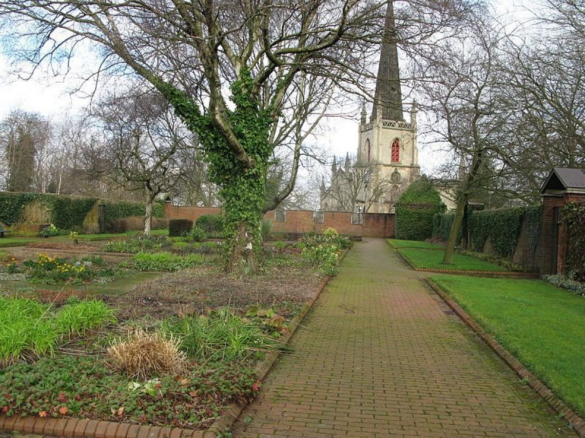
The Memorial Garden, as here defined c 2ha, lies immediately south of St Matthew's church, at the south-east end of High Street, on Church Hill at the heart of the medieval town. The hill is bounded by Church Hill to the north-east, Peal Street to the north-west and New Street to the south-west, while to the east the site is bounded by a hedge which defines the west boundary of an open grass space connecting Hill Street and Birmingham Street.
ENTRANCES AND APPROACHES
There are several approaches to the hilltop garden, the main one from the north-west, via the steep and cobbled Church Hill. At the top of this, along the south side of the churchyard and convenient for its lych gate entrance, is a small car park.
GARDENS AND PLEASURE GROUNDS
Jellicoe's scheme comprises three separate elements: the Memorial Garden, the Terrace, and St Matthew's Close and its flats.
The Memorial Garden itself is rectangular, 70m long from south-west to north-east and 25m wide. It lies within a 3m tall wall of handmade red brick in Flemish garden wall bond capped with artificial stone copings. This wall has a number of distinct architectural features. Equidistantly spaced down the south-east side are three doorways with open, concrete pediments. The doors themselves are steel grilles. Along the north-west side are three shallow bays for benches. The north-east, end wall is pierced by high, square, window-like openings edged with artificial stone which give glimpses of St Matthew's church and the sky. Either side of the north corner is another open-pedimented doorway, each opening onto a small, semicircular railed balcony. That to the north-east provides a view towards the church, that to the north-west a panoramic view (now somewhat obscured by London planes on the hillside below) over the Terrace below and across the town. Both exploit the Garden's position, along the west edge of the summit of Church Hill. At the east corner of the Garden is a brick, pavilion-like memorial chapel with undercroft. This projects north beyond the corner of the Garden as an artificial stone structure with full height mullion and transom windows supported on two round columns with walkway beneath. The two bays of the chapel are covered with a roof in the form of twin, copper-sheathed, truncated pyramids.
The interior of the Garden is divided up by a grid-like arrangement of paths, relaid c 1994 with red-brick paviours. Narrow lawns run down the two long sides of the garden while the interior, divided up by paths laid in Greek key pattern, is occupied by beds with shrubs and irregularly spaced silver birch trees. At the north-east corner of the garden, close to the memorial chapel, is a circular pool, 8m in diameter and with a simple jet fountain. In the south-west corner is a raised circular slate slab bearing the dates of the two World Wars and also that of 1 May 1951 when work on the garden began.
Attached to the outside of the south-west corner of the Memorial Garden is a two-storey Modern Movement gardener's house with small balconies on each of the four, rough-cast sides of the upper floor. This stands at the head of the Terrace, which runs along and slightly below the north-west wall of the Memorial Garden and was designed by Jellicoe as a viewing terrace or promenade walk with sweeping views over Walsall towards Wolverhampton. The north-east side of the house projects forward, with its first floor supported on four round columns, originally providing an open verandah-like area for seating looking down the Terrace. The Terrace is now surfaced with red-brick paviours divided into bays by small buff-coloured flagstones. Two rows of six low, square, planting compartments run down the interior. This scheme, of the 1990s, replaced the original one which comprised gravel within the bays and a staggered avenue of whitebeam planted in pre-cast concrete planting boxes. From the north-east corner of the Terrace a flight of shallow steps leads down to Church Street, close to the point where it joins Church Hill.
In 1998 the gardener's house, previously derelict, was being renovated as a private house. A short section of the Terrace had been sold off with the house.
The gardener's house occupies a tower-like position on the corner of Church Hill. West of it the ground falls sharply away; adjoining the house are mature shrubs, while to the north, running down to the railings along Church Street which runs around the base of the hill, is a grassy slope.
East of the Memorial Garden is St Matthew's Close, an undulating square c 100m across. It is bisected by a road also called St Matthew's Close, which runs north-east to south-west across its centre connecting New Street to the south with the parking area south of St Matthew's church. The rest of the Close is mown grass with shrubs and some mature trees, notably a row of London planes alongside the Memorial Garden. Along the south side of the Close, and abutting the south-east corner of the Memorial Garden, is a terraced row of two-storey flats, brick with low, pitched tile roof, through which St Matthew's Close road passes through a two-storey opening. The flats have open balconies opening on to the Close, and were constructed to designs prepared by Jellicoe. Immediately north-east of the east end of the flats is the Brotherhood or Church Hall, again by Jellicoe, under the projecting east end of which is a balcony-like platform giving views east. This lies on a curving path with hedge which defines the east side of the Close, connecting Birmingham Street with the churchyard. The Church Hall, which replaced one on the Memorial Garden site, was originally intended to be aligned north/south rather than, as now, east/west, further to enhance the cathedral close-like feel of St Matthew's Close.
REFERENCES
J Lovie, Memorial Garden, Walsall, (site report for English Heritage 1998)
Description written: July 1998
Register Inspector: PAS
Edited: October 1999
- Visitor Access, Directions & Contacts
Access contact details
This is a municipal park for general public use.
Owners
Walsall Council
The Civic Centre, Walsall, WS1 1TP
- History
The following is from the Register of Parks and Gardens of Special Historic Interest. For the most up-to-date Register entry, please visit the The National Heritage List for England (NHLE):
www.historicengland.org.uk/listing/the-list
HISTORIC DEVELOPMENT
The area south of St Matthew's church (until the late C18 All Saints) was at the heart of the medieval town of Walsall, and by the C18 was heavily built-up. By the C19, however, the commercial centre of the town had moved west to the area around The Bridge and Park Street and many of the properties on Church Hill had become dilapidated. There was some demolition south of the church in the middle of that century, and further slum clearance in the 1930s when the area's inhabitants were moved to new council houses.
Church Hill was left largely open, and after the Second World War was declared an 'Area of Special Development' with a high priority for reconstruction. In 1947 Geoffrey Jellicoe (kt 1979) was awarded a contract to design an ambitious scheme whereby the hilltop would be left open as a garden, to include a memorial to the town's war dead, which would be linked to the town by bridges. Jellicoe's final scheme was slightly less ambitious. The initial phase of the project included the construction of the greater part of the Memorial Garden and the Terrace, opened in 1952. The second phase, comprising the building of the memorial chapel in the Memorial Garden, and the flats and Brotherhood or Church Hall to the south of the open space known as St Matthew's Close, was completed c 1960. The buildings were intended to preserve, to some extent, the church's urban setting. The Memorial Garden and Terrace were restored c 1994 when some changes were made to the materials used for paths and surfacing. In 1998 the gardener's house was under restoration.
- Associated People
- Features & Designations
Designations
The National Heritage List for England: Register of Parks and Gardens
- Reference: GD4178
- Grade: II
- Key Information
Type
Garden
Purpose
Commemorative
Principal Building
Parks, Gardens And Urban Spaces
Survival
Extant
Hectares
2
Open to the public
Yes
- References
References
- {English Heritage Register of Parks and Gardens of Special Historic Interest}, (Swindon: English Heritage, 2008) [on CD-ROM] Historic England Register of Parks and Gardens of Special Historic Interest