Introduction
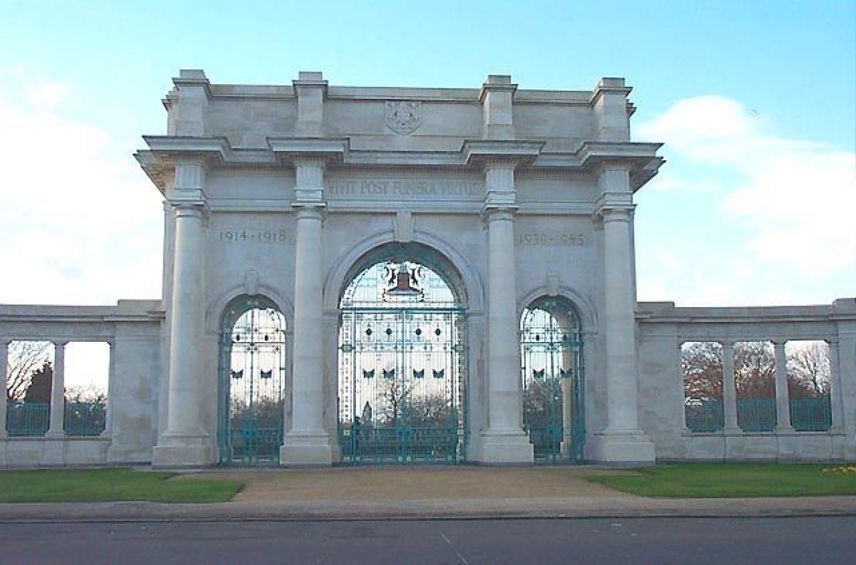
The Memorial Gardens, commemorating the dead of World War 1, are early 20th-century gardens laid out on land donated by Sir Jesse Boot. They lie on the Victoria Embankment of the River Trent and incorporate the city's war memorial in the form of an arch and terrace.
The following is from the Register of Parks and Gardens of Special Historic Interest. For the most up-to-date Register entry, please visit The National Heritage List for England (NHLE):
A public garden donated by Sir Jesse Boot and laid out by Mr J Parker, the Superintendent of the Nottingham Public Parks Committee; the site was completed in 1927 and remains a public garden.
Location, Area, Boundaries, Landform and Setting
The Memorial Gardens are c3ha in size and are located c2km south of Nottingham city centre and c450m south-west of Trent Bridge. The Gardens are enclosed and gated. The east boundary is against the Victoria Embankment carriage drive and is marked by a wrought-iron fence on a concrete plinth. The fence continues to form the boundary around the southern tip, including the bandstand area. The west margin is set against recreation grounds that formed the remainder of Jesse Boot's gift of land and is marked by a hedge and railings. The perimeter of the Gardens in the north is marked by the boundary with the King's School, and a public footpath that leads to Fraser Road. The boundary is formed by a hedge and railings. The Gardens are sunken in the centre where they sit below the Terrace and rise to the north and south to reach the level of the Embankment.
ENTRANCES AND APPROACHES
The Gardens are designed to be approached from Victoria Embankment in the east. The main entrance is marked by the Memorial Arch which overlooks the river and dominates the area. Pedestrian and service access is provided by two modest entrances to the north and south; the latter now (2000) has late C20 gates of utilitarian design. Pedestrian access is also provided from the recreation grounds to the north-west corner of the Gardens.
PRINCIPAL BUILDINGS
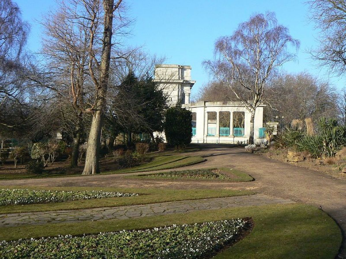
There are two principal buildings within the garden. The classical triumphal arch known as the Memorial Arch (listed grade II). Designed by the city engineer and surveyor, Mr T Wallis Gordon, the Portland stone memorial consists of a three-span archway flanked by colonnades, with a terrace overlooking the Gardens and the River Trent. The foundation stone was laid by the Prince of Wales on 1 August 1923 and the Arch was unveiled and dedicated on Armistice Day 1927. To the south is a bandstand with terracing designed in 1937 in the Moderne style and is listed at Grade II.
GARDENS AND PLEASURE GROUNDS
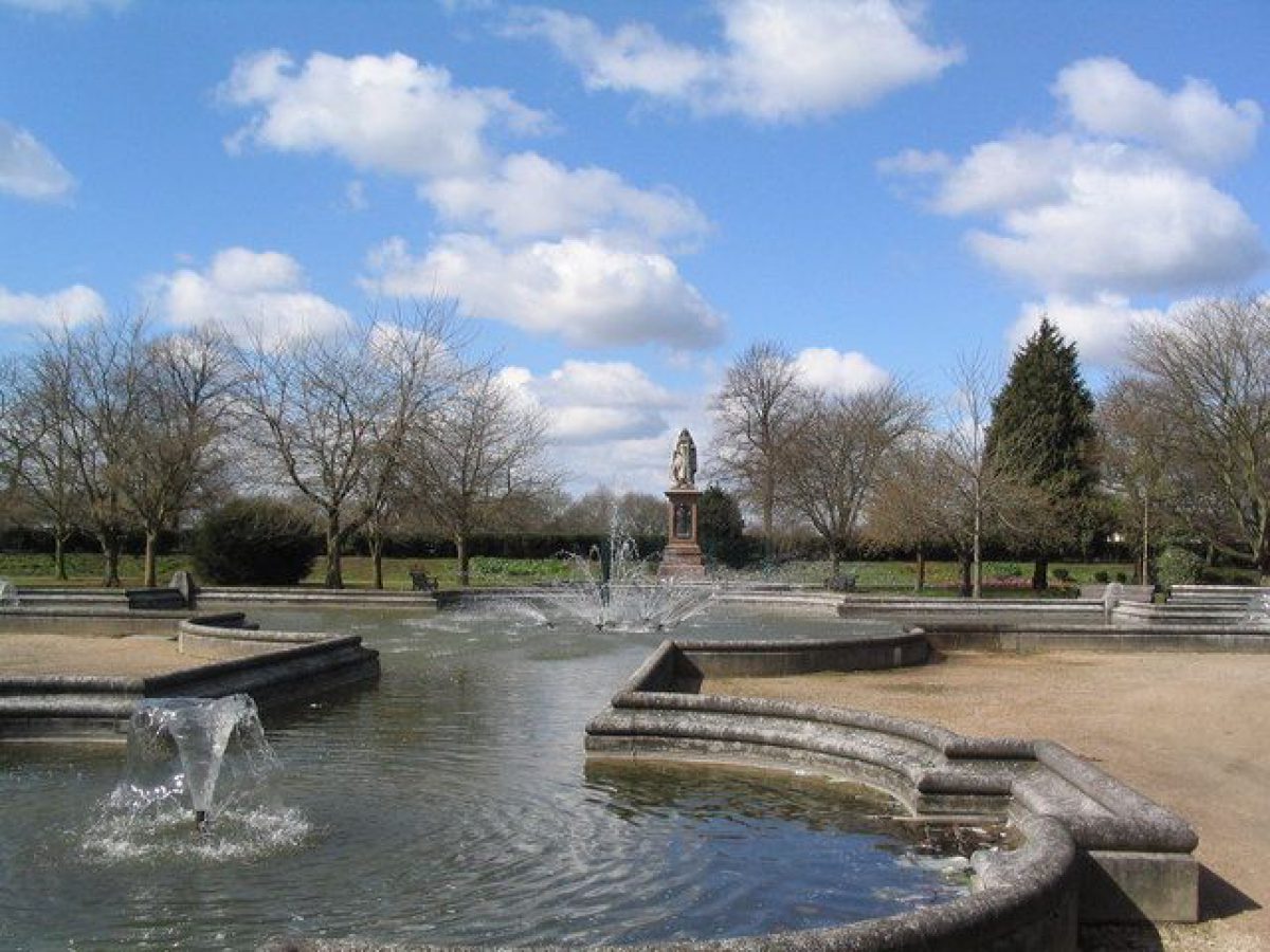
The Memorial Gardens are laid out on a formal axial plan. Aligned in a north/south direction, the Gardens are dominated by the Memorial Arch and Terrace (listed Grade II). The Terrace, immediately to the west of the Arch, is c3m high and houses three shelters (pump room) and toilets as well as affording good views over the central features of the Gardens: a statue of Queen Victoria (listed Grade II) and a cross-shaped ornamental pool (listed Grade II). The pool surround is formed from white pre-cast concrete elements, similar in material to that used for the Terrace balustrade.
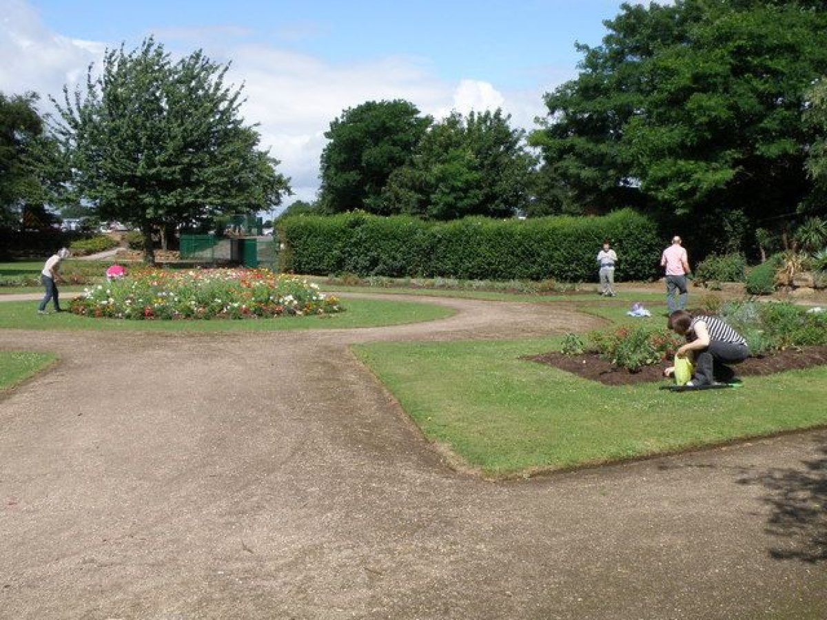
Paths are laid around the Gardens' perimeter and along the principal south/north axis. The north/south path is c180m long. A rockery occupies the north-east area c85m north of the Arch. Paths through the rockery converge on a geometric circular rose garden in the northwest of the Gardens. The rose garden also serves to terminate the principal north/south path. A works depot is located immediately to the north of the rose garden, with access from the recreation grounds. To the south, the Gardens are laid out with a series of geometric island beds and lawns. Photographs from c1927 show the paths in the Gardens, including those around the formal pool, surfaced in stone crazy paving. This has now (2000) been replaced by gravel throughout the Gardens except for the rockery paths, which retain their stone paving.
At the southern extreme is a fan-shaped piece of land that has an approximate area of 0.29 hectares and is laid out in asymmetrical arrangement. The area is enclosed by evergreen hedges that are approximately 1.4m high, along the south-west and north-east boundaries. Iron railings of similar height continue along the south-eastern boundary. Inside the boundary are rectangular beds that are planted with specimen shrubs and mature deciduous trees. A fan shaped area of lawn sweeps from the south corner across to the east corner, with footpaths along the sides allowing access to Victoria Embankment. Terraced hardstanding follows the line of the lawn to the north-west corner, descending gently towards the Art Deco bandstand (listed Grade II) which terminates the view at the north east extreme.
The planting throughout most of the Gardens comprises specimen trees and shrubs on slightly raised lawns. Floral planting is reserved for the east border and areas at either end of the north/south path. Photographs from c1930 indicate that the south circular beds were richly bedded out. They are now (2000) rose beds or set to lawn.
Maps
- OS 6" to 1 mile: 1st edition surveyed 1879/82, published 1886; 2nd edition published 1901; 3rd edition published 1920; 1938 edition
- OS 25" to 1 mile: 1st edition surveyed 1880, published 1884; 2nd edition published 1901; 3rd edition published 1914; 1930 edition
Archival items
- Minutes of the Parks Committee 1917/19 and 1928 (Nottinghamshire Archives)
- City of Nottingham, Public Parks Committee Minute Books 9/11 (Nottinghamshire Archives)
- Public Parks and Burial Ground Committee Annual Report, 3 October 1938 (Nottinghamshire Archives)
- Early to mid C20 photographs (Nottingham Local Studies Library)
Reasons for designation
The Memorial Gardens, Victoria Embankment, Nottingham is designated at Grade II for the following principal reasons:
- History: For its association with Jesse Boot, founder of Boots the Chemist, who gifted the land to the citizens of Nottingham so that it could be preserved as open space and a memorial site in perpetuity.
- Group value: The landscaping provides a dignified setting for the triumphal arch and the statue of Queen Victoria, which are both listed at Grade II.
- Intactness: The original layout and design remains intact including plant beds, footpaths and many of the mature trees.
Description written: December 2000
Edited: May 2001
Amended: Feb 2011, December 2021
- Visitor Access, Directions & Contacts
Access contact details
The Memorial Gardens are a public open space.
Owners
Nottingham City Council
The Guildhall, South Sherwood Street, Nottingham, NG1 4BT
- History
The following is from the Register of Parks and Gardens of Special Historic Interest. For the most up-to-date Register entry, please visit The National Heritage List for England (NHLE):
19th Century
The Memorial Gardens was the final phase of developments that took place on the north bank of the River Trent, which runs c2km south of Nottingham city centre. The river between Trent Bridge in the east and Wilford Bridge in the west is characterised by a large meander c2km in length. At the end of the C19 much of the land enclosed within the bend was in private ownership and prone to flooding. The land-owner, Mr H R Clifton, donated c9ha to the Nottingham Corporation so that flood defences could be built. Mr Arthur Brown, the Nottingham Corporation Engineer, was responsible for the earthworks and construction, which took place between 1898 and 1901 when the Victoria Embankment was opened. The north bank of the river was secured with concrete steps which, in combination with the raised bank, served to provide a flood defence and a public walk of c2km which linked the Trent and Wilford Bridges. As a result of the Victoria Embankment securing the north bank of the Trent, work was undertaken on filling and levelling the hinterland to create recreation and sports grounds in the western section of the meander; the Meadows Recreation Ground was opened in May 1906.
20th Century
In 1920 the Clifton Estate offered for sale a piece of land that was situated in the eastern section of the meander. It was bought by Sir Jesse Boot, the founder of Boots the Chemist whose home, the Plaisaunce, lay almost opposite the purchased land on the south bank of the Trent. The land was given to the Corporation of Nottingham in 1920 so that it could be preserved as open space and a memorial site in perpetuity. At the time it was called New Park. The gift in total comprised c14.7ha, of which c12ha were dedicated to recreation grounds and playing fields for the adjacent Mundella Secondary School, Collygate School, and Trent Bridge School. The eastern edge of the site, overlooking the Victoria Embankment and River Trent, was laid out as the Memorial Gardens to commemorate those who had lost their lives in the First World War.
Mr J Parker, the Superintendent of the Public Parks Committee, was responsible for laying out the park, and the City Engineer's Department, under the leadership of the City Engineer and Surveyor, Mr T Wallis Gordon, designed the Memorial Arch and Terrace. In 1926, the rock gardens in the north of the Memorial Gardens were considered to be sufficiently advanced to admit the public but although the Arch's foundation stone was laid by the Prince were officially opened on Armistice Day of that year. The bandstand, terracing, and landscaping were added to the south extreme, and opened to the public on 12th May 1937, the Coronation day of King George VI.
The Memorial Gardens and the Victoria Embankment have retained their names but the name New Park is no longer used, all the playing fields being known simply as the Meadows Recreation Grounds.
Period
- 20th Century (1901 to 2000)
- Early 20th Century (1901 to 1932)
- Features & Designations
Designations
The National Heritage List for England: Register of Parks and Gardens
- Reference: GD4750
- Grade: II
Features
- War Memorial
- Description: The Nottingham War Memorial, Trent Embankment
- Ornamental Fountain
- Statue
- Description: Statue of Queen Victoria by Albert Toft.
- Rockery
- Description: A rockery occupies the north-east area.
- Entrance
- Description: The main entrance is marked by the Memorial Arch.
- Terrace
- Description: The Terrace, immediately to the west of the Arch, is around 3m high and houses three shelters and toilets.
- Fence
- Description: Wrought-iron fence.
- Drive
- Description: Victoria Embankment carriage drive.
- Arch
- Description: The classical triumphal arch known as the Memorial Arch. Designed by the city engineer and surveyor, Mr T Wallis Gordon, the Portland stone memorial consists of a three-span archway flanked by colonnades.
- Earliest Date:
- Latest Date:
- Bandstand
- Description: The bandstand is in the Moderne style.
- Earliest Date:
- Latest Date:
- Pool
- Description: A cross-shaped ornamental pool.
- Path
- Description: Paths are laid around the Gardens' perimeter and along the principal south/north axis.
- Rose Garden
- Description: Paths through the rockery converge on a geometric circular rose garden in the north-west of the Gardens.
- Island Bed
- Description: To the south, the Gardens are laid out with a series of geometric island beds and lawns.
- Lawn
- Specimen Tree
- Description: The planting throughout most of the Gardens comprises specimen trees and shrubs on slightly raised lawns.
- Key Information
Type
Park
Purpose
Commemorative
Principal Building
Parks, Gardens And Urban Spaces
Period
20th Century (1901 to 2000)
Survival
Extant
Hectares
2.7
Open to the public
Yes
- References
References
- {English Heritage Register of Parks and Gardens of Special Historic Interest}, (Swindon: English Heritage, 2008) [on CD-ROM] Historic England Register of Parks and Gardens of Special Historic Interest
- Pevsner, N. and E. Williamson, {The Buildings of England: Nottinghamshire} (Harmondsworth: Penguin, 1979), p. 248 The Buildings of England: Nottinghamshire
- Nottingham Evening Post, July 1906 'Opening of the Embankment, Nottingham'
- Nottingham Evening Post, 31 May 1906 'Meadows New Recreation ground: Opening by the Mayor'
- Mellors, R., (1914) Old Nottingham Suburbs: Then and Now
- Nottingham Guardian, 9 September 1927 'Sir Jesse Boot's Generosity'
- Mellors, R., (1926) The Gardens, Parks and Walks of Nottingham and District
- Weir, C., (1994), pp 64/5 Jesse Boot of Nottingham
- Nottingham Guardian, 12 November 1927 'Unveiling of War Memorial Arch'
- Nottingham Journal, 11 November 1927 'Unveiling Day