
Introduction
Levens Hall has a medieval deer park which was converted into a landscape park in about 1700. An oak lined avenue was also added at this time. Garden features include a late-17th and early-18th century topiary garden beside the hall. There is also an orchard, nuttery, herb garden, bowling green, rose garden and fountain garden.
Terrain
In the valley of the River Kent.The following is from the Register of Parks and Gardens of Special Historic Interest. For the most up-to-date Register entry, please visit The National Heritage List for England (NHLE):
A park and gardens laid out by Guillaume Beaumont between 1689 and 1712 which retain almost all of the essential elements of the completed scheme as shown on maps of the park and gardens of 1730.
Location, Area, Boundaries, Landform and Setting
Levens Hall is situated c 5km south-west of Kendal. The c 45ha site is situated in the valley of the River Kent in a setting which is rural and agricultural. The parkland consists of two separate areas of land, one to the north-east of the Hall on the far side of the A6, and the other to the west. The boundary to the north-eastern park is formed by a stone wall which completely encloses it. The boundary of the gardens and western park is formed by a stone wall on the east side, and a stone wall on the western boundary for a length of c 130m. The remainder of the southern and the western boundary is formed by a C20 fence, and the northern boundary is formed by the River Kent.
Entrances and Approaches
The main entrance is marked by a gateway with stone gate piers with pineapple finials (probably mid C19, listed grade II) on the west side of the A6. A drive leads westwards across the north front of the Hall and continues south-westwards to a service courtyard to the west of the Hall. A secondary entrance to the Hall is formed by gate piers and gates (listed grade II) aligned with the north front of the Hall. There is another entrance with gates and stone gate piers with ball finials from a lane running west then south-west from the A6. This leads to the extreme south-west corner of the gardens and was formed in the C20. Entrances to the north-eastern park are formed by a set of stone gate piers and gates, one on each side of Levens Bridge (listed grade II) which carries the A6 over the River Kent. There is another entrance on the north-east side of the park from a minor road between Hincaster and Sizergh. This is called Park End and is shown, with the other entrances, on a plan of the park by Russell of 1816. There is an informal entrance from a footpath via a stile on the north-west side of the park.
Principal Building
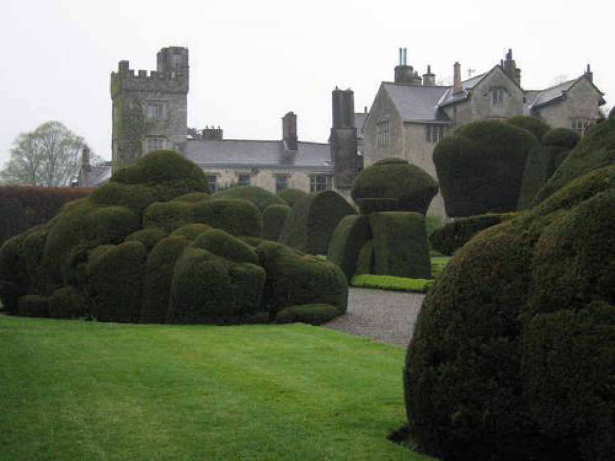
Levens Hall (listed grade I) originated as a pele tower and is probably of C13 date. The building was altered and refurbished c 1580 by James Bellingham. It is the largest Elizabethan house in the county and retains a fine contemporary interior. An L-shaped service block is attached to the south-west of the Hall enclosing a cobbled courtyard. Some 70m north-east of the Hall there is a stable range (C17, listed grade II*), now converted for residential use, to which is attached, at the southern end, a small house built for Guillaume Beaumont and used as the Head Gardener's residence since that time.
Gardens and Pleasure Grounds
The gardens are situated on the north, east and south sides of the Hall. A walled forecourt to the north has gates leading to a drive aligned with the Hall's main entrance which ends in a semicircular gravelled area. There are lawns on either side of the drive and a grassed terrace between the gravelled sweep and the front of the Hall, with stone steps leading up to the entrance. This is much as shown on Skyring's 1730 plan of the gardens except that the wall dividing the stables and gardener's house from the forecourt has disappeared.
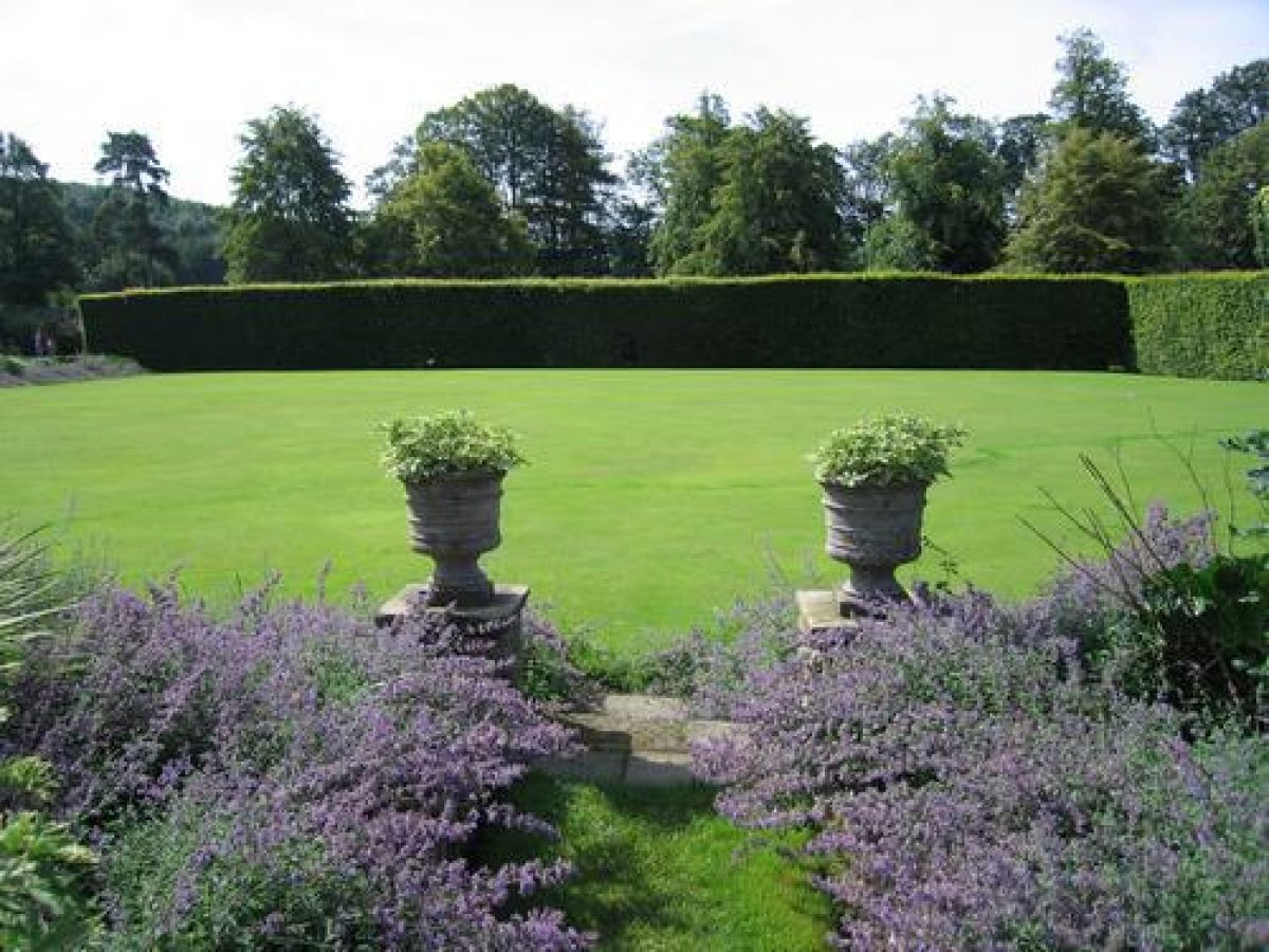
The gardens to the east and south of the Hall are entered from a gate in the south-east forecourt wall. They consist of a central square of four compartmental gardens of equal size. To the south, beyond a beech hedge, is an irregularly shaped area called The Wilderness; to the north there is a rectangular area in the angle formed by the south side of the gardener's house and the east side of the Hall. On the east side the East Walk runs the full length of the gardens. Another axial path runs eastwards along the south side of the Hall to join East Walk. On the west side there is a path running south along the edge of a ha-ha, with a semicircular bastion (listed grade II) c 35m south of the Hall giving views into parkland. The ha-ha is one of the earliest known examples in the country and is mentioned in family papers from 1695 onwards. The garden area is walled on the east and south sides, enclosed by the Hall and the gardener's house on the north side, and separated from parkland by the ha-ha on the west side.
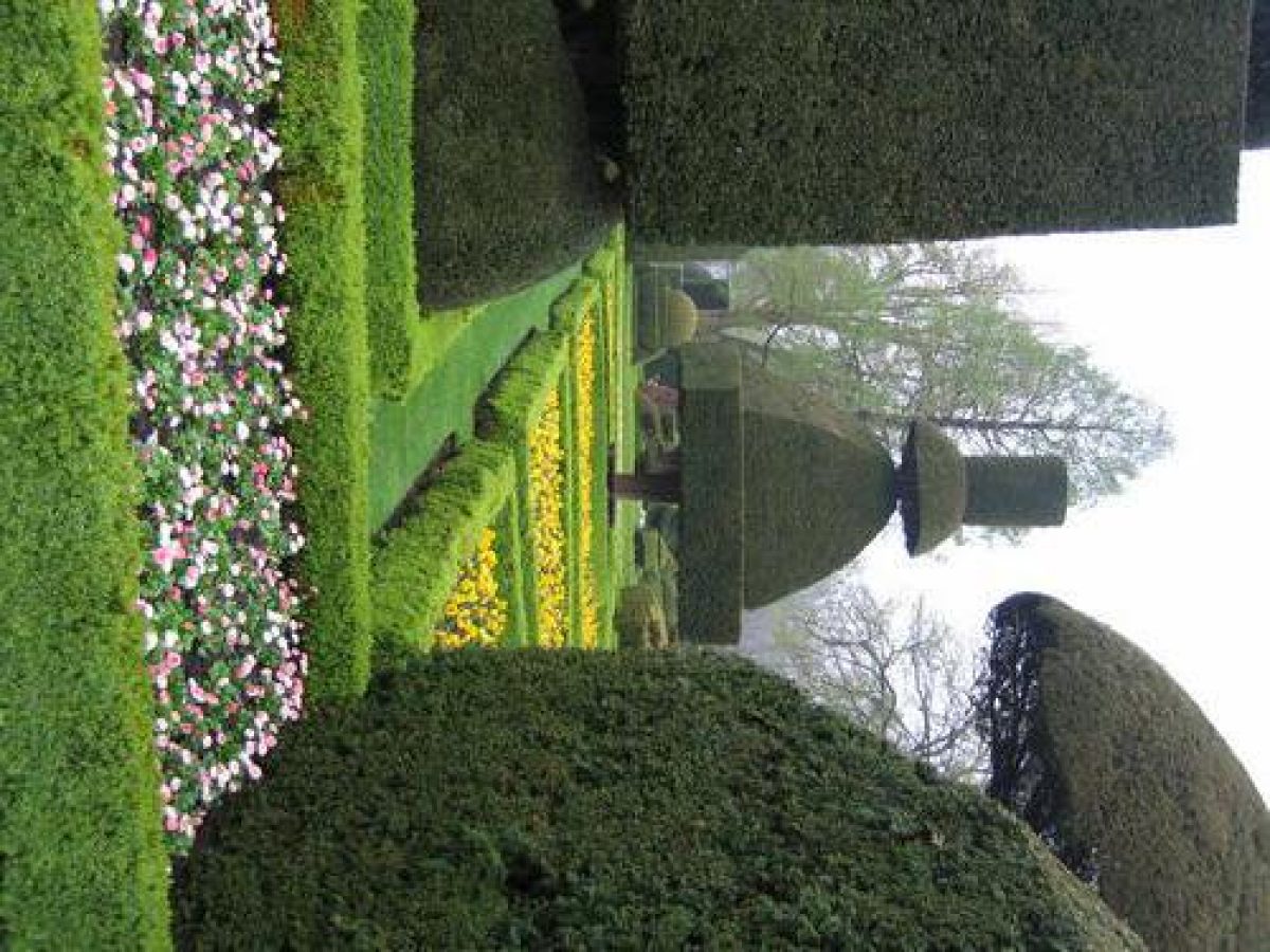
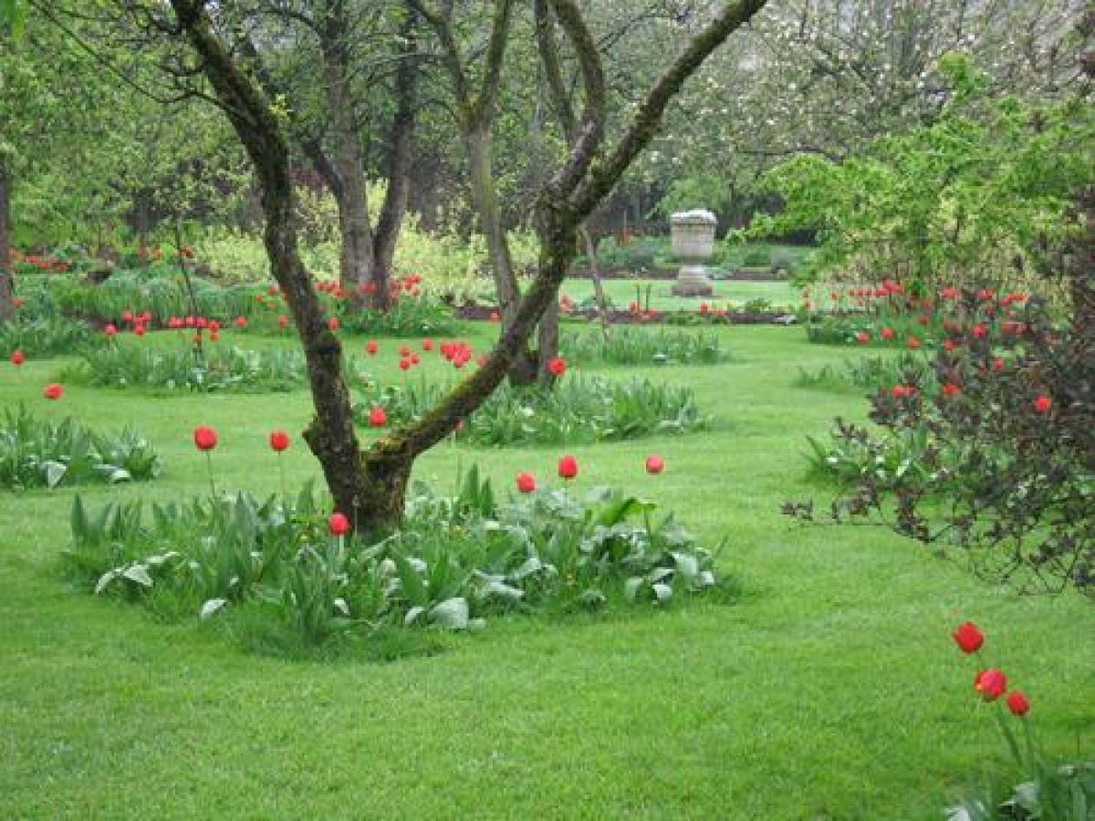
The four central gardens are divided from one another by a hedged walk called the Beech Walk. This runs from north to south and has a circular central area from which grass walks lead off to the east and west. The north-west compartment has a central circular area and quartering axial paths. It is used as a vegetable garden and nuttery. The north-east garden, known as the Orchard, is laid out with a circular central area and cross paths mirroring the design of its neighbour; it is planted with fruit trees. Both of these gardens conform to the layout shown on the 1730 garden plan. The south-eastern garden is called the Bowling Green, and has a level close-clipped lawn; it is shown with a game of bowls in progress on the 1730 plan. A bowling green is thought to have existed before this part of the garden was laid out in its present form because bowls marked with the Bellingham arms (ie pre 1688) are preserved in the Hall. The south-west garden, called the Fountain Garden, has quartering axial paths bordered by pleached limes leading from a central circular fountain. This garden was laid out during the 1990s recreating the plan of the garden as shown on the 1730 plan and introducing the fountain in the position of what is shown as a circular area. The earlier layout, shown in slightly modified form on the 1816 map, was obliterated by tennis courts during the early C20. The southern part of the garden, called The Wilderness, has a small building called the smoke house (C17, modified C19, listed grade II) at the southern end of the East Walk in the angle of the east and south walls. This is shown on the 1730 plan. The south side of The Wilderness has a path running alongside the wall which is lined with mature lime trees on the garden side. The 1730 plan shows that the line now planted as the Beech Walk continued through The Wilderness to the southern wall, and that there was a garden with radiating walks on the east side of this line and a garden with a pattern of straight east/west walks between circular plots planted with trees on the west side. The 1816 map shows the area planted with trees. The southern wall has a centrally positioned ornamental arch which forms the termination of a vista looking south down the Beech Walk. This appears to have been constructed during the C20 incorporating a pediment of earlier date.
The north-east corner of the garden, called the Topiary Garden, is divided into four rectangular areas by paths, also as shown on the 1730 plan. These are divided into geometrical shapes with low box hedges and the area is planted with yew and golden yew topiary in a wide variety of forms. Beaumont created the topiary garden and it was restored by Alexander Forbes, Head Gardener from 1810-62, who recut the surviving yews, planted anew, and introduced box hedging.
On the west side of the Hall a plot has been laid out with geometric beds edged with box in the style of a C17 garden. This was created during the 1990s.
Park
There are two distinct areas of parkland at Levens Hall. To the north-east a c 33ha stretch of parkland is situated on either side of the River Kent. It is divided from the Hall, gardens and remaining parkland by the A6 which was constructed as a turnpike during the 1750s. The Kent runs south-westwards through the centre of the park; at the south end there is a small flat-bottomed valley and the banks of the river become steeper to the north, becoming precipitous in places towards the north-eastern boundary. The banks are generally wooded apart from a more open area at the southern end of the park. An avenue, called The Avenue, runs eastwards along the southern edge of the park for a distance of c 500m from the entrance on the south side of Levens Bridge, then turns and runs north-eastwards to the edge of the park. From it there are views of the winding River Kent. Shown on Skyring's 1730 plan of the park as well as Russell's plan of 1816, it consists almost wholly of oak trees which vary from ancient specimens through to recently planted saplings reflecting a programme of management in the centuries following planting. The trees are planted at approximately regular intervals of c 10-12m.
On the north side of the river a line of mature trees, mainly limes, runs eastwards from a point c 100m north of the entrance for a distance of c 150m. This is the remains of an avenue shown on the 1st edition OS map surveyed 1858. It is approximately on the line of an avenue shown on Skyring's map of the park of c 1730, when it was related to two other short avenues, one running south along the park boundary and another running north-eastwards from the park entrance along the banks of the Kent for a distance of c 100m. The 1816 map shows a slightly different disposition of the three avenues suggesting that the line which survives was replanted after 1816. Some of the scattered mature trees in this corner of the park may be survivors of the early C19 arrangement.
Some 450m north-east of the northern park entrance, on the slopes of Deer Hill, there is a group of three clumps of mature trees which are probably the survivors of a range of platoons along the west side of the Kent shown on the estate map of 1816. In one of the clumps a mature beech tree is carved with a seemingly authentic date and the letters 'RS 1760'.
With the exception of the western boundary and that part of the southern edge bounded by The Avenue, there are belts of planting along the perimeter of the park. This is much as shown on the 1858 OS map. In 1730 the most significant planting was on the north-west side of the site in an area which is called Lily Wood. A lesser plantation on the north-west edge of the park is also shown. The 1816 map shows that Lily Wood had rides cut through it along the south-western and north-western edges.
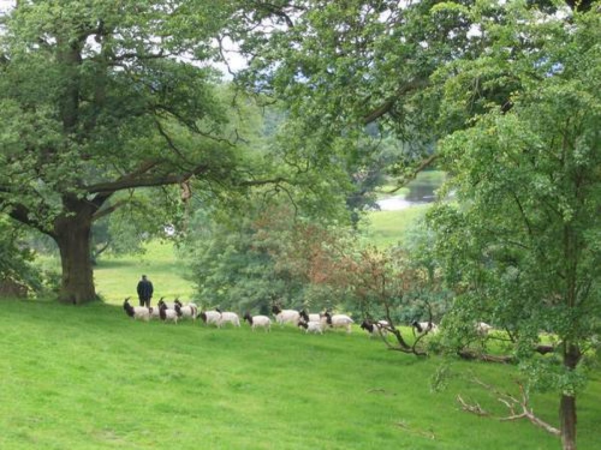
The park was laid out by Beaumont during the period 1689-1712 and remains much as shown on the plan of 1730. It was visited by William Gilpin in 1776 who described it as 'a happy combination of everything that is lovely and great in landskip' (Batey and Lambert 1990, 92). It is currently (1997) used for pasture and supports a herd of black fallow deer.
Parkland situated to the west of the Hall and gardens covers an area of c 12ha. It consists of a level area of land with some scattered trees which is used for pasture. Aligned with the ha-ha bastion there is an avenue of trees. This is shown on the 1816 map as platoons and the vestiges of that arrangement are shown on the 1858 OS map. This area is shown on Jeffreys' county map of 1770 occupying a larger area than it does at present, but it is not covered by the plans of the gardens and park of 1730.
Maps
- R Skyring, A Map of Leavens Garding, c 1730
- R Skyring, A Mappe of Leavens Park, c 1730
- T Jeffreys, The County of Westmorland, 1770
- J Russell, A Plan of Levens Park belonging to R. Howard Esq., 1816
- C & J Greenwood, Map of the County of Westmorland, 1824
- OS 6" to 1 mile: Westmorland sheet XLII, 1st edition surveyed 1858
- OS 25" to 1 mile: Westmorland sheet XLII.11 (B), 1st edition surveyed 1858
Archival items
- Typescript notes on Beaumont taken from family papers at Levens Hall, nd (private collection)
Description written: July 1997
Amended: June 1998
Edited: March 1999
- Visitor Access, Directions & Contacts
Telephone
015395 60321Website
https://www.levenshall.co.ukAccess contact details
The site is open from April to September, Sunday to Thursday, 10am to 5pm. Please see: http://www.levenshall.co.uk/visiting-levens/admission-details-levens-hall.html or telephone 01 539 560321
Directions
From the M6 junction 36, follow A590/A6 south. The site is signed. http://www.levenshall.co.uk/visiting-levens/finding-levens-hall.html
- History
The following is from the Register of Parks and Gardens of Special Historic Interest. For the most up-to-date Register entry, please visit the The National Heritage List for England (NHLE):
www.historicengland.org.uk/listing/the-list
HISTORIC DEVELOPMENT
A pele tower was erected on the site by the de Redman family in about 1250-1300. The de Redmans sold the site to Alan Bellingham in 1562 and it remained in the Bellingham family until 1688 when it was sold to Colonel James Grahme. Grahme invited Guillaume Beaumont (d 1727) to design the park and gardens. Beaumont remained at Levens until his death in 1727 and a portrait dated about 1700 has the inscription: 'Monsieur Beaumont Gardener to King James 2 & to Col Ja Grahme. He laid out the Gardens at Hampton Court Palace and at Levens.'
The estate remained in the Grahme family, passing through marriage to the Howard family and subsequently to the Bagot family. It remains (1997) in private ownership.
- Associated People
- Features & Designations
Designations
The National Heritage List for England: Register of Parks and Gardens
- Reference: GD1658
- Grade: I
Features
- Tree Avenue
- Description: An oak avenue.
- Earliest Date:
- Latest Date:
- Topiary
- Earliest Date:
- Latest Date:
- Orchard
- Bowling Green
- Rose Garden
- Boundary Wall
- Description: The boundary to the north-eastern park is formed by a stone wall which completely encloses it.
- River
- Description: River Kent
- House
- Description: Levens Hall (listed grade I) originated as a pele tower and is probably of C13 date.
- Stable Block
- Description: stable range (C17, listed grade II*), now converted for residential use
- House
- Description: Head Gardener's residence
- Walled Garden, Gardens
- Description: The gardens to the east and south of the Hall are entered from a gate in the south-east forecourt wall. They consist of a central square of four compartmental gardens of equal size
- Ha-ha
- Description: One of the earliest known examples in the country
- Smoke House
- Description: small building (C17, modified C19, listed grade II)
- Parkland
- Description: To the north-east c 33ha of parkland on either side of the River Kent. To the west of the Hall and Parkland and gardens of c 12ha.
- Fountain, Formal garden
- Description: Levens Hall, Fountain Garden was created in 1994. It has pleached limes around its borders.
- Key Information
Type
Park
Purpose
Ornamental
Principal Building
Domestic / Residential
Survival
Extant
Hectares
45
Open to the public
Yes
Civil Parish
Levens
- References
References
- Pevsner, N {The Buildings of England: Cumberland and Westmorland} (London: Penguin, 1967) pp 268-270 The Buildings of England: Cumberland and Westmorland
- {English Heritage Register of Parks and Gardens of Special Historic Interest} (Swindon: English Heritage 2008) [on CD-ROM] Historic England Register of Parks and Gardens of Special Historic Interest
- Estate office {Levens Hall Historic Landscape Management Plan} (1990) Levens Hall Historic Landscape Management Plan
- Morris, F. O., (1866-1880), p 49 A Series of Picturesque Views 6
- 18 November 1899), pp 624-628; (25 November 1899), pp 656-659; 60 (9 October 1926), pp 538-546; (16 October 1926), pp 578-586; (23 October 1926), pp 610-617; 145 (9 January 1969), pp 62-63; 147 (26 March 1970), pp 782-784 Country Life, 6
- Triggs, H I., (1902) pp 27-28 Formal Gardens in England and Scotland
- Holme, C., (1911), pp 72-80 The Gardens of England in the Northern Counties
- Elliott, B., (1986), pp 58-59 Victorian Gardens
- Batey, M, and Lambert, D., (1990), pp 90-94 The English Garden Tour: a view into the past
- Crowder, C., (nd, c 1995) Levens Hall Garden Guide