Introduction
Leonardslee is a 'collectors garden' set in a designed landscape of 92 hectares (86 hectares registered). The garden was started by Sir Edmund Loder in 1889 although many trees on the site pre-date this. Leonardslee is noted for its rhododendrons and azaleas and features seven lakes, an alpine house, a temperate greenhouse and a rock garden.
Terrain
A deep, sheltered, north to south stream valley, its slopes rising steeply on the west side to level ground.www.historicengland.org.uk/listing/the-list
An early 20th-century landscaped plantsman's garden with early 19th-century origins and with mid- to late 20th-century addition and development.
DESCRIPTION
LOCATION, AREA, BOUNDARIES, LANDFORM, SETTING
Leonardslee lies on the east side of the A281 Cowfold to Horsham road, in the village of Lower Beeding. The 86ha site, which comprises 32ha of ornamental gardens and a further 54ha of parkland and woodland, lies within a deep, sheltered, north to south stream valley, its slopes rising steeply on the west side to level ground alongside the A281 and on the east side, on more gentle contours, towards the crest of Hogstolt Hill. The site is bounded on its west side by clipped hedging and an intermittent internal tree fringe along the A281, on the west side of which are the C19 landscaped gardens of South Lodge and Selehurst. The cottages and farm buildings of Crabtree abut the south-west corner. To the north, east and south the site merges beyond its enclosing agricultural fencing into the surrounding landscape of small-scale valleys and crests occupied by well-wooded farmland.
ENTRANCES AND APPROACHES
The site is entered on the west side from the A281 beside a small, octagonal, two-storey lodge known as the Round House (listed grade II), moved to its present position from Horsham in the 1820s (owner pers comm, 1997). The drive follows an easterly, then a south-easterly, gently downhill course, flanked by trees and shrubbery, to the principal, west front of the mansion. En route, on its east side, the drive passes a two-storey brick and tile-hung house, built in 1985 as the Loder family home and some 75m further on (20m north of the mansion), the U-shaped range of the carriage house and stables surmounted by a clock tower, built during the 1850s (guidebook 1993) and converted to a restaurant in 1988. Immediately to its west a brick outbuilding, formerly housing generators for the electrical supply to the house, now contains a bonsai collection (opened 1991) and a collection of Victorian motor cars; an adjacent Alpine House was built and opened in 1992. A further drive to the west front of the house enters from the A281 at the Lower or South Lodge in the extreme south-west corner of the site.
PRINCIPAL BUILDING
The mansion of Leonardslee (listed grade II) sits on a natural terrace above the steep west side of the valley, commanding extensive views east and south over the gardens to Hogstolt Hill and to the South Downs some 15-25km distant. The two-storey Italianate house, built in ashlar with a slate roof, sash windows and an entrance porch supported on four rusticated Tuscan columns, was designed and built from 1853 to 1855 by T L Donaldson (1795-1885). It replaced an earlier, stone-built house on the same site, designed by John Johnson (1732-1814) c 1801 for Charles Beauclerk and known as St Leonards Lodge, the name soon being changed to Leonardslee with Donaldson's new house. The present house was reduced in size c 1971 and then renovated and converted to office accommodation by Eurotherm International in 1984.
GARDENS AND PLEASURE GROUNDS
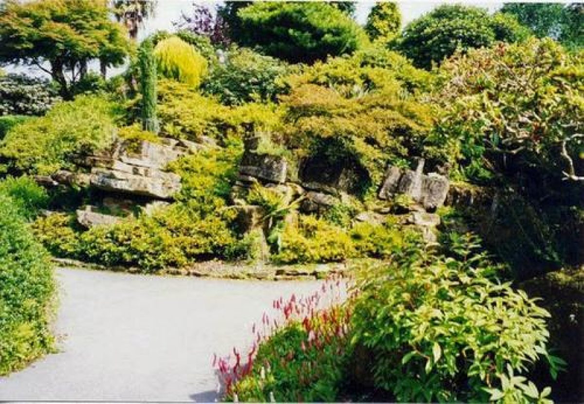
The ornamental gardens lie largely on the east- and west-facing slopes of the valley, to the north, east and south-east of the mansion and with further smaller areas to its immediate west and south-west. On the east side, the garden front of the mansion opens onto a series of steep, grassed terraces with a central flight of steps leading down to a lower lawn, enclosed on its south-east side by shrubbery and along its south side by a ha-ha (the line of which is shown on the sale plan of 1852). On the south front, the mansion opens onto level lawns with islands of shrubbery and the Camellia Walk, while on its west side, beyond the forecourt car park and enclosed by a fringe of trees and shrubs, is the Rock Garden. Constructed in c 1900 by Messrs Pulham (guidebook 1993) and roughly oval in shape, it is laid out as a series of stratified, rocky outcrops which combine natural sandstone with artificial Pulhamite rock and which are intensively planted with hummocks of azaleas, dwarf rhododendrons and dwarf conifers. Paths weave around the outcrops and set within them on the west side end of the garden is a small pool, adjacent to which is the site of a former fernery (Garden Hist 1989), now demolished. North-west of the rock garden is a large temperate greenhouse used for plant sales.
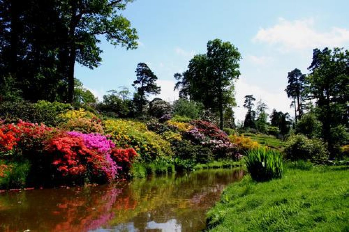
North of the mansion, two parallel main routes, an upper and a lower lakeside path, lead northwards through the gardens covering the western slope of the valley, the routes being interconnected by secondary paths criss-crossing the slope. Some 100m north of the mansion, the upper path runs along the broad, gravelled New Terrace, laid out below the new (1985) Loder house, which overlooks grassy slopes framed with azaleas, specimen maple and cherry trees and hybrid rhododendrons and from which there are glimpses of the lakes in the valley below. Northwards beyond the Terrace and above the upper path is the Loderi Garden, planted with a wide range of species rhododendron beneath a light canopy of mature trees including fir and larch and containing original plants of Rhododendron loderi raised by Sir Edmund in 1901. Northwards again, on slopes shown planted with trees and shrubs in 1874 (OS 1st edition), Middle Walk passes through further glades of rhododendron and other exotic shrubs and small trees growing beneath mixed exotic trees including gingko, Dawn and Californian redwoods. At its far northern end, the upper path opens into the Dell, from which there are fine views southwards to the chain of lakes in the valley below. The Dell, laid out as an American garden by the Beauclerk family before 1852 (sale particulars), is planted with trees and shrubs of mixed ages, some surviving from the early C19, including rhododendron, dogwood, magnolia, cedar, redwood, fastigiate beech and oak. A focal point of the Dell is the Memorial Table, a Sussex millstone with an inscription in memory of Sir Edmund Loder.
From the Dell, the upper path descends open grassy slopes to the Clapper bridge spanning a pond on the northern boundary, before joining the main, lower path which winds the length of the valley alongside the chain of four major lakes and several smaller ponds. Of these, only the southernmost New Pond (a former hammer pond) is shown on the sale plan of 1852, the remaining ponds being constructed in the late C19 and in some cases enlarged in the late C20. Southwards from the Clapper bridge pond are the Top Ponds, constructed between 1874-5 and 1909 (OS editions) and planted with shrubs and waterside plants, and Mossy Ghyll Pond, established at the same period but enlarged in the late C20. A dam containing the south end of Mossy Ghyll Pond gives access to the lower slopes of the east side of the valley and to the deep Ghyll itself, these areas being planted with hybrid rhododendrons and azaleas beneath a light canopy of pine and oak. Towards the top of the Ghyll, on its north side, is the Top Garden, planted with varieties of Rhododendron loderi in 1952.
South of Mossy Ghyll Pond is Engine Pond, constructed between 1852 and 1874, which is fringed with Scots pine and which was extensively planted with deciduous azaleas in 1992. At its southern end is a small brick pump house, shown on the 1st edition OS map and formerly housing pumps to supply the estate's water. Southwards below its dam is Waterfall Pond, with water entering over a rocky fall in its north-east corner. This lake was created in its present, enlarged form in the late C20 and incorporates the former Beaver Pond which housed beavers from 1899 to 1947 (guidebook 1993). The lake surrounds were extensively cleared and remodelled in 1992-3, the immediate banks planted now for autumn colour and the eastern slopes with azaleas and above with large collections of species and varieties of oak and maple. The grassy western banks are now open in character and dotted with trees. On the upper slopes to the south-west of Waterfall Pond is the Camellia Grove, planted in 1957-8 by Sir Giles Loder mainly with several hundred cultivars of Camellia japonica. To its north is a collection of sorbus on the Sorbus Bank. South of Waterfall Pond the lakeside path continues southwards to complete a circuit around the shores of New Pond which was created in the mid C18 from two older ponds (ibid).
A complete and detailed description of the planting in Leonardslee Gardens is contained in the current guidebook.
PARK
The park lies above the valley, on the south-west-facing slopes of Hogstolt Hill and in a belt to the west and south of the house. Hogstolt Hill, known as the Old Park and in use as a deer park for most of the C19 (ibid) is now (1997) grazed by deer and wallabies, its turf scattered with a light cover of clumps and individual mature native trees including oak, beech, sweet chestnut and pine. The woodland increases in density towards the north-west side of the hill, on the slopes above the Waterfall Pond. South Hanger Wood, its mature beech trees badly damaged in the storm of 1987, forms a boundary belt along the lower, east end of the hill. The parkland above the valley to the south-west, known as the New Deer Parks, and a connecting strip running northwards parallel to the main road, are both open in character and laid to pasture dotted with occasional mature individual trees or small clumps. This pattern of landscape is shown established on the OS 1st edition surveyed in 1874.
REFERENCES
Country Life, 8 (1 September 1900), pp 282-5; 125 (23 April 1959), pp 876-8; 161 (17 March 1977), pp 630-2
T Wright, Gardens of Britain 4, (1978), pp 155-61
Garden History 12, no 2 (1989), p 150
Leonardslee Gardens, guidebook, (1993)
Victoria History of the County of Sussex 6 part 3, (1986), pp 15, 21-2
Maps
OS 6" to 1 mile: 1st edition surveyed 1874-5, published 1879; 3rd edition published 1913
OS 25" to 1 mile: 1st edition surveyed 1874; 3rd edition published 1911
Archival items
Sale particulars and map of 1852 (private collection)
Description written: November 1997
Amended: January 2000
Edited: June 2000
- Visitor Access, Directions & Contacts
Telephone
0871 8733 389Access contact details
The site is open daily between April and October.
- History
The following is from the Register of Parks and Gardens of Special Historic Interest. For the most up-to-date Register entry, please visit the The National Heritage List for England (NHLE):
www.historicengland.org.uk/listing/the-list
HISTORIC DEVELOPMENT
The land of St Leonards Forest was granted by Charles II to his physician, Sir Edward Greaves, from whom it passed to the Aldridge family. In 1801, some 400 hectares of the Aldridge estate in the south of the parish were sold to Charles George Beauclerk who built a house called St Leonards Lodge on the site and began to lay out the gardens and park. In about 1852 the estate was bought by William Egerton Hubbard who built the present mansion and continued to develop the gardens, selling the estate to his future son-in law Sir Edmund Loder. From 1889 until he died in 1920, Sir Edmund greatly expanded the gardens and created a large collection of rare wild animals including unusual species of deer, wallabies and a colony of beavers. The gardens suffered a period of neglect during the 1930s and early 1940s but were restored and improved by Sir Edmund's grandson, Sir Giles Loder, from 1946 (Victoria County History). On his retirement in 1981, management of the gardens was taken over by his son, Robin Loder, and they remain (1997) in private ownership while the mansion, known as Leonardslee, and a narrow surrounding band of land is in separate, commercial ownership.
- Features & Designations
Designations
The National Heritage List for England: Register of Parks and Gardens
- Reference: GD1056
- Grade: I
Features
- Pulhamite
- Mansion (featured building)
- Description: The present house was built by William Egerton Hubbard.
- Earliest Date:
- Latest Date:
- Hedge
- Description: The site is bounded on its west side by clipped hedging.
- Gardens
- Trees
- Greenhouse
- Rock garden
- Lake
- House
- Key Information
Type
Garden
Purpose
Ornamental
Survival
Extant
Hectares
92
Open to the public
Yes
Civil Parish
Lower Beeding
- References
References
- {English Heritage Register of Parks and Gardens of Special Historic Interest}, (Swindon: English Heritage, 2008) [on CD-ROM] Historic England Register of Parks and Gardens of Special Historic Interest
- Wright, T., {The Gardens of Britain 4: Kent, East & West Sussex and Surrey} (London: Batsford, 1978), pp.155-61 The Gardens of Britain 4: Kent, East & West Sussex and Surrey
- Hudson, T.P, {Victoria County History: Sussex, Volume 6 (Part 3)} (Oxford: Oxford University Press, 1987), pp. 15 and 21-2 Victoria County History: Sussex, Volume 6 (Part 3)
- Hitching, C {Rock Landscapes: The Pulham Legacy} (Garden Art Press, 2012) Rock Landscapes: The Pulham Legacy