Introduction
Leeds Castle has a medieval deer park which was landscaped in the 18th century. There was later 20th-century development associated with the moated castle. The gardens are now used for cultural events and historical displays.
Since 1978 more attractive and ‘historic' gardens have been created in the form of kitchen garden areas, notably a Culpeper Garden of 15th and 16th century design and planting. A vineyard has also been planted on the site of one recorded in the Domesday Book.
Visitor numbers have dramatically increased since regular opening in 1977, and the development of the gardens and grounds is planned to provide a greater diversity of interest to the visitors. This is continuing with the construction of an elaborate and remarkable grotto and maze complex in the former fruit gardens area on sloping ground overlooking the Great Water. Simon Verity was the architect of the Grotto 1985-7. The Duckery and Wood Garden have also been further developed. Elaborate shop and restaurant facilities are provided at the Castle.
The landscape character of the site is outstanding, making a valuable contribution to the area. The A20 and Hollingbourne to Leeds zone of the M20 extension has had a serious impact. A tree survey is needed.
There has been very considerable and severe loss and damage in the parkland area due to storm damage. Many important trees have been lost. Screen belts along the A20 have been largely destroyed, causing visual and noise intrusion. A consultant's survey was undertaken in summer 1988 as a basis for a major restoration and replanting programme in 1989-90.
The following is from the Register of Parks and Gardens of Special Historic Interest. For the most up-to-date Register entry, please visit the The National Heritage List for England (NHLE):
www.historicengland.org.uk/listing/the-list
A park of medieval origin surrounding a 13th-century moated castle, further landscaped in the early 18th century and significantly replanted in the early 19th century; additional mid- and late 20th-century ornamental gardens by Russell Page.
DESCRIPTION
LOCATION, AREA, BOUNDARIES, LANDFORM, SETTING
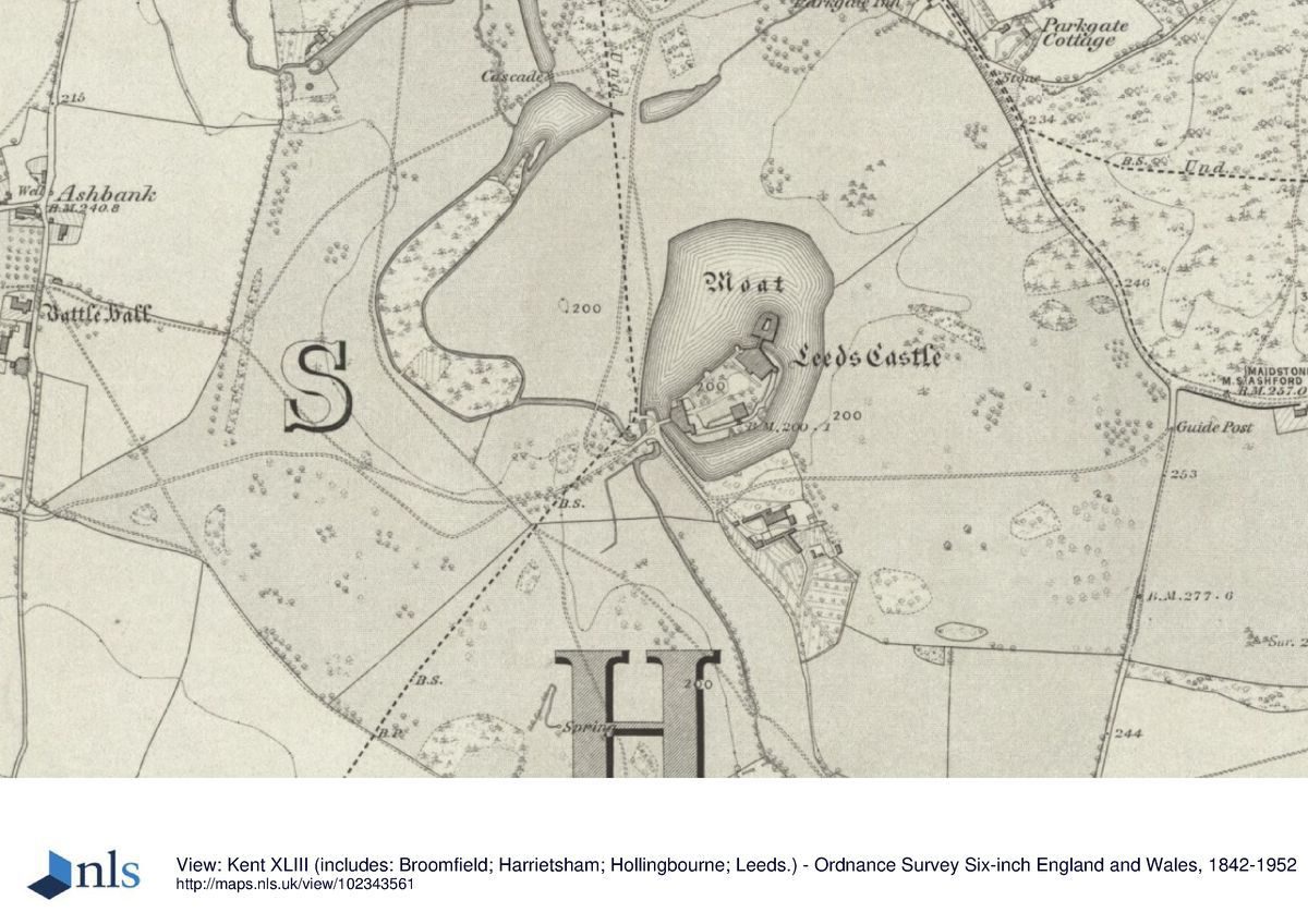
Leeds Castle lies c 6km to the south-east of Maidstone, on the immediate south side of the A20/M20 roads and on the eastern edge of Leeds village. The registered site comprises c 6ha made up of the moated castle, ornamental gardens, lake and ponds, surrounded by c 140ha of parkland and woodland. The River Len flows through the centre of the site from south-east to north-west, the valley sides rising immediately to the south-west and west of the river, forming to the west a high, steep, bowl-shaped bank. East of the river the ground rises to a lesser height and in more gentle undulations. The site is bounded to the north by the A20 and, c 100m further north, by the M20 on an embankment visible from the park. The ridge of the North Downs lies some 2km beyond and parallel to the roads. To the west and east minor roads form the boundary: the B2163 to the west and Broomfield Road to the east. To the south the park landscape merges with mixed farmed and wooded land, also owned by the Foundation, which surrounds the site to the west, south, and east.
ENTRANCES AND APPROACHES
The present main vehicular entrance to the Castle, which is also the public entrance, is from the B2163, 230m south of its junction with the A20. This entrance was created in the late C20, with the addition of the brick gate piers in the late 1980s. The drive runs due east before joining a drive running south from an entrance off the A20, shown established on Thomas Hogben's map of 1748 and flanked by twin, two-storey stone lodges (built to designs by Owen Little FRIBA in the 1920s, listed grade II). The drive follows a straight south-easterly course for c 950m, passing after 250m the present ticket office and shop buildings, from which a footpath leads visitors southwards to the Castle along the river valley. The drive turns southwards along the west side of the moat, crossing the narrow channel of the River Len on a stone bridge. It then loops north-eastwards and crosses the dam controlling the south end of the moat which is guarded by the remaining walls of the C13 Inner and Outer Barbican, the latter incorporating the ruins of a pre-1086 mill and constructed originally with three gates to serve approaches from the north-west, west, and south-east (dam and Barbican ruins listed grade I). Approaches from these directions appear to have been in continuous use from the C13 and are shown on Hogben's map (1748), the present drive following the north-west approach shown lined with avenue trees along the first 600m from the A20 (these had gone by 1865-6, when the OS 1st edition was surveyed). The present entrance from Broomfield Road is flanked by twin lodges (Owen Little, listed grade II) of similar appearance and date to those on the A20.
PRINCIPAL BUILDING
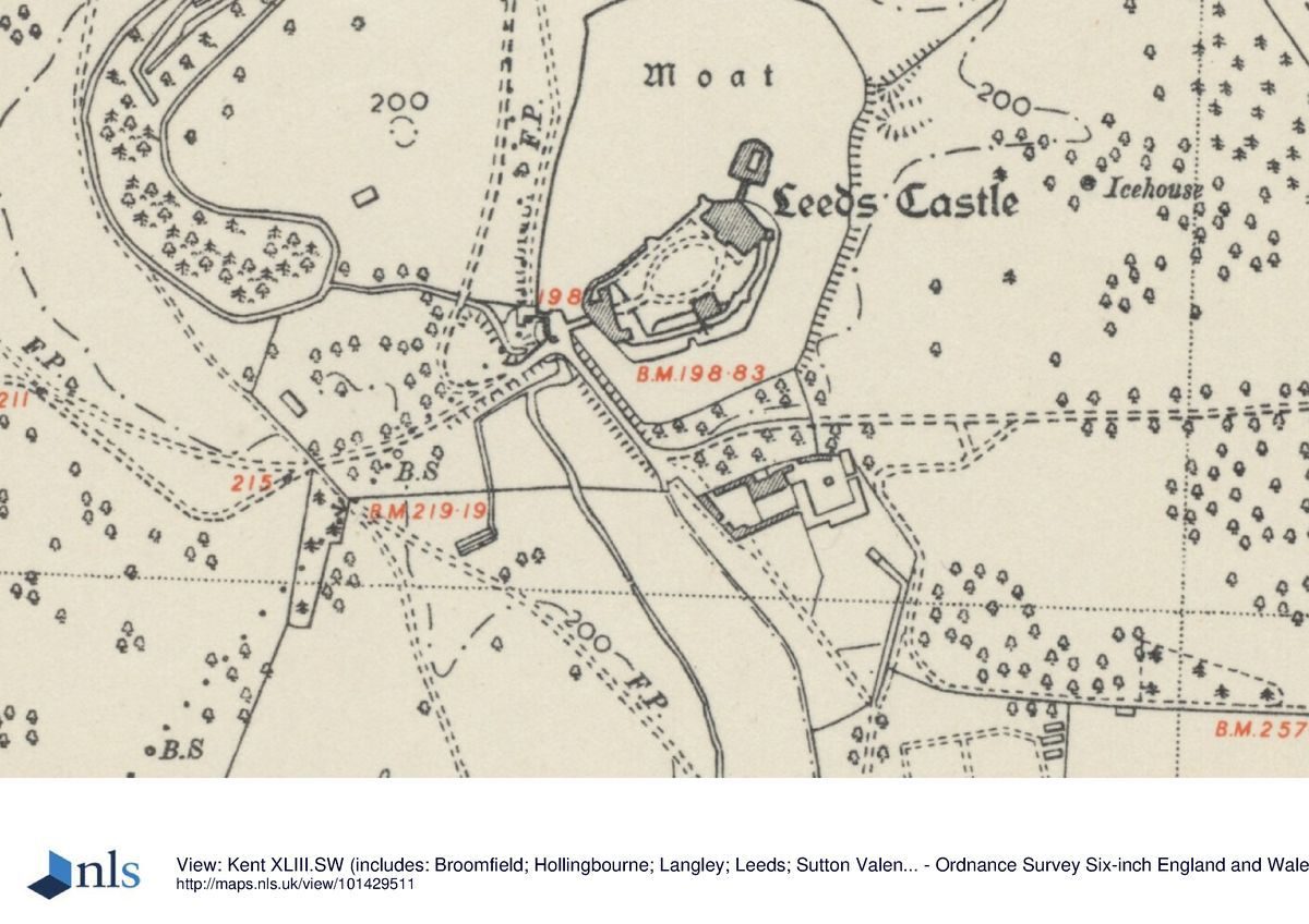
Leeds Castle (listed grade I) lies virtually at the centre of the registered site and consists of an ensemble of four separate, major buildings: the main Castle, the Gloriette, the Maiden's Tower, and the Gatehouse. All are situated on islands in a moat which is probably of C13 origin (guidebook). The main castle, begun in 1119, is a two-storey, rectangular, ragstone block with battlements and octagonal angle-turrets. It sits at the north-east end of the larger island which is surrounded by 5m high stone revetment walls added in the C13 and strengthened by D-shaped turrets, the one to the south-east surviving complete. The Castle was further improved in the C16 by Henry VIII and then rebuilt by the Smythe family in the early C17 as a Jacobean house (anonymous illustration, guidebook) which was altered in the Strawberry Hill Gothick manner by Robert Fairfax from the 1750s. Fiennes Wykeham Martin demolished this house and, with William Baskett of Camberwell as his architect, built the present Castle in 1822-3. On a small island to its north-east and connected by a two-storey stone bridge (an 1822 replacement of a former timber structure) is the Gloriette, built from 1119 in an extended D-shape as apartments ranged around a narrow courtyard with a fountain. Its upper floor was probably added in the C16. It was restored to its present appearance as part of the restoration of 1822. The south-west front of the Castle opens onto an oval, grassed forecourt, on the south side of which stands the two-storey, rectangular Maiden's Tower, of C14 origin but with Tudor alterations and battlements added in the late C18. At the south-west end of the island and connected to the Barbican by a two-arched stone bridge is the low, square, ragstone gatehouse block with ranges to north and south. It is of C12 origin with C13 and C14 alterations.
GARDENS AND PLEASURE GROUNDS
The ornamental gardens lie both to the north-west of the Castle, along the winding floor of the River Len valley, and to its south-east, on the rising eastern slopes of the Great Water. From the Barbican a broad path leads south-eastwards along the causeway above the dam separating the moat from the north-east shore of the Great Water. Although known to have been flooded as an additional defence measure in the medieval period, the present 450m long lake was formed as part of Russell Page's landscape proposals for Lady Baillie in the mid C20. South-eastwards beyond the causeway the path diverges slightly eastwards away from the shore of the Great Water to lead through a courtyard formed by the Fairfax Hall, formerly a barn and of C17 origin in part, and by associated C19 and C20 stable and garage buildings, now (1997) in use as conference accommodation, restaurants, and shops. An archway in the south-east side of the courtyard leads into a wedge-shaped, south-west-sloping garden overlooking the Great Water and enclosed by brick walls which supported former glasshouses (OS 1897). Created by Russell Page (1906-85) in 1980 and known as the Culpeper Garden, it is laid out in a pattern of geometric, box-edged beds abundantly planted with a mixture of English cottage garden and exotic plants. The main path leads along the lower, south-west side of the garden and is lined with a row of twelve yews in the form of truncated pyramids and a yew hedge. Beyond the yews, on the east bank of the Great Water and on the site of former mid C20 aviaries, a new terraced garden with an Italian Mediterranean theme, known as the Lady Baillie Garden, was built and planted in 1998-9.
South-east of the Culpeper Garden is the Aviary, built as a series of five-sided, pitch-roofed mesh enclosures surrounded by brick walls on the site of late C19 kitchen garden land (OS 1870) and opened in 1988. Some 100m further south-east is a large square maze, also opened in 1988, its plan, forming a queen's crown, laid out with yew hedges set within trellis-work frames. Its centrepiece is a rocky mound beneath which, and reached by stone steps, is a grotto with several rooms, its varied decoration in stone, brick, and minerals based on mythological themes (CL 1988). Immediately south of the maze is a range of glasshouses and nursery buildings, the central range established by the mid C20 and in use for plant and fruit production. East of the nursery, part of the land abutting the Broomfield Road boundary is laid out as a vineyard, replanted in 1980 on the site of a vineyard recorded in Domesday Book (guidebook).
Some 50m west of the moat, on the north side of the River Len, the Pavilion Garden, designed by Francois Goffinet in 1986, is laid out as a level lawn framed by flowering shrub borders and trees and overlooked on the west side by a two-storey, rustic timber-clad pavilion. The garden was largely replanted in the late 1990s. Beyond the Pavilion Garden the path follows a winding course north-westwards along the narrow valley floor between the two parallel streams of the River Len. At its south end, where the western stream flows into a long pond, the valley is planted as a Woodland Garden with a light cover of native and exotic trees underplanted informally with shrubs and waterside plants. Further north a second, smaller pond forms the focus of a Water Garden with colourful, moisture-loving herbaceous planting and scattered trees. The ornamental landscaping of the valley was begun in the 1920s by Lady Baillie and created as a spring garden from c 1936 by Russell Page. Its present (1997) planting was designed by Francois Goffinet in the late 1980s.
North of the Water Garden the eastern stream feeds into the Cedar Pond which is also fed, via a cascade, from a further pond on its east side. These ponds, open on their south sides to the expanse of lawns sweeping north-westwards down the slope from the moat, are known to have existed since at least 1086 (guidebook, Domesday Survey). Two mature cedars close to the north and south sides of the large pond survive from a group planted between 1865-6 and 1898 (OS). Replacement cedars were planted in the late 1980s. At its north end the pond flows over a 5m deep, stepped cascade built by William Baskett in 1827 (Wykeham-Martin papers) into the 150m long canal of the Duckery. Enclosed by grassy banks and ribbons of shrubbery and trees and containing a collection of wildfowl, the Duckery was created in the 1960s for Lady Baillie by the designers Stéphane Boudin and Russell Page. From the north end of the Duckery, the course of the Len flows westwards through a further canal (shown on Hogben's 1748 map), on the north bank of which (300m from the western site boundary) is Weir Cottage (early C19, listed grade II).
PARK
The park surrounds the Castle on all sides, the present open parkland, which is grazed, lying to its north-west, west, and south-west. South-west of the Great Water the land rises as an open, treeless slope with woodland plantations, largely of C20 origin, in both the southern and extreme eastern corners of the registered site. On the slopes west of the Great Water and above the River Len there is a light scatter of loose groups and individual trees, some planted as replacements following the storm of 1987. North-west of the Duckery and Weir Cottage, the park is well wooded around the perimeter, the central area of open grass dotted with tree clumps incorporating picnic sites and, on the east side of the main drive, hard standings for cars. The remainder of the east side of the park is occupied by a golf course, laid out in the 1930s, the fairways interspersed with both tree belts and scattered trees and with the main entrance adjacent to the Park Gate Inn (listed grade II) on the A20.
Thomas Hogben's map shows that in 1748 the designed parkland extended to the present northern and eastern site boundaries and southwards to the line of the approaches to the Castle from Leeds village (to the west) and from Broomfield Road (to the east). Its western limit lay some 200m to the west of the river, on the line of a present north to south avenue of mixed age trees. Hogben shows the parkland open in character but with well-developed formal planting in the form of strategically placed clumps, avenues, and several small woods. Although described in c 1750 as being 'beautifully adorned with wood and ...improved by the present owner' (Bishop Pococke, with reference to Robert Fairfax, in Cartwright 1808), the work was more probably that of the fifth Lord Fairfax in the early C18 (guidebook); no evidence exists for Lancelot Brown (1716-83), who worked at neighbouring Leeds Abbey in 1771-2, having done so at Leeds Castle. The park received little attention until the Wykeham-Martins undertook restoration and improvement works in 1823-5 (Cleggett 1994). The OS 1st edition shows an increase in imparked land with planting extending south of the east and west approach drives; although the avenues had gone, the late C19 tree pattern otherwise appears little changed from that shown on Hogben's map of 1748. An icehouse, of which no trace now (1997) survives, lay c 300m east of the Gloriette.
REFERENCES
J Cartwright, The Travels through England of Dr R Pococke, (Camden Society 1808)
C Wykeham-Martin, The History and Description of Leeds Castle, Kent (1869)
Country Life, 1 (24 April 1897), pp 435-6; 34 (6 December 1913), pp 806-14; (13 December 1913), pp 856-62; 80 (28 November 1936), pp 568-74; no 18 (5 May 1988), pp 166-7
J Newman, The Buildings of England: West Kent and the Weald (1969), pp 355-8
Kensington Hortorium, Masterplan for Leeds Castle (1989)
M Schinz and G van Zuylen, The Gardens of Russell Page (1991), pp 118-19
D Cleggett, A History of Leeds Castle and its Families (1994)
Leeds Castle, guidebook, (revised edn 1994)
Maps
J Andrews, A Dury and W Herbert, A Topographical Map of the County of Kent, 2" to 1 mile, 1769
Thomas Hogben, The Topographs and Mensuration of Leeds Castle, 1748 (U825 P7), (Centre for Kentish Studies, Maidstone)
OS 6" to 1 mile: 1st edition surveyed 1865-6, published 1870; 2nd edition 1898; 3rd edition 1909; 1946 edition
OS 25" to 1 mile: 2nd edition 1897; 3rd edition 1908
Archival items
The Wykeham-Martin papers are held by the Leeds Castle Foundation.
Description written: August 1997
Amended: June 1999
Edited: November 2003
- Visitor Access, Directions & Contacts
Access contact details
The site is open throughout the year, with earlier closing in the winter months. Please see: https://www.leeds-castle.com/Visit?id=rge_tabs
Directions
The site is 1 mile south-east of Leeds village, 5 miles south-east of Maidstone off the A20. Please see: https://www.leeds-castle.com/Visit/Getting+To+Leeds+Castle
- History
The first Saxon Castle was sited here on the green, fertile, and well-watered valley of the River Len, running from the North Downs ridge to the north-east. The castle grew in size and importance with particular enlargements under the Royal Direction of Edward I and Henry VIII. Edward built the lower storey of the ‘Gloriette' while the Tudors added the upper storey. The building history is disjointed. Much building took place in the early-16th century, but it was in 1822 that extensive rebuilding and additions took place under Fiennes Wykeham-Martin. He added turrets and battlements as well as restoring the main castle.
The park was probably landscaped at that time. Many trees have been planted that are magnificent today, especially cedars, beeches and oaks. No formal gardens of any note were created. In the 1920s Leeds was purchased by the Honourable Lady Baillie who, from 1926 onwards, carried out a full and careful restoration of the castle fabric as well as developing ornamental water gardens and estate parkland.
The Wood Garden was her creation with the help of the garden architect Russell Page, where she was able to introduce unusual wildfowl as a special interest. A nine-hole golf course was also laid out. Very extensive walled kitchen gardens were developed to the south-east of the castle and ranges of glasshouses.
On the death of Lady Baillie in 1976, the castle and a considerable endowment were bequeathed as the Leeds Castle Foundation - a charitable Trust for medical research and the arts.
The following is from the Register of Parks and Gardens of Special Historic Interest. For the most up-to-date Register entry, please visit the The National Heritage List for England (NHLE):
www.historicengland.org.uk/listing/the-list
HISTORIC DEVELOPMENT
The present castle was begun in about 1119 by Robert de Crèvecoeur. It was ceded to Edward I in 1278 and remained a royal castle until granted to Sir Anthony St Leger in 1552. In 1618, financial ruin forced Sir Anthony to sell Leeds to his wife's uncle, Sir Richard Smythe, who built a Jacobean house on the main island. The Smythe family sold the estate to Sir Thomas Culpeper of Hollingbourne in 1632. His son, Sir Cheney, died intestate and Leeds was bought by a cousin, Thomas, second Lord Culpeper, whose father, the first Lord Culpeper, had been rewarded for political services with large landholdings in America. Through the marriage in 1690 of his daughter, Catherine, to Thomas, fifth Lord Fairfax, Leeds passed to the Fairfax family. The sixth Lord Fairfax emigrated to America in 1745 to manage his estates, giving Leeds to his brother Robert, later to become the seventh Earl, who made alterations and gothicised Sir Richard Smythe's house. Leeds passed to Fairfax's nephew in 1793 and then to the latter's brother, General Philip Martin who left Leeds and the fortune from the sale of his American estates to a distant relative, Fiennes Wykeham (who took the additional name of Martin). He largely rebuilt the Castle to its present appearance and laid out the park between 1822 and 1825. Leeds remained in the Wykeham-Martin family until the death of Cornwallis Wykeham-Martin in 1924. It was bought in 1926 by the Hon Mrs Wilson Filmer, later to become Lady Baillie. She reconstructed the interior of the Castle and created the present ornamental gardens. After her death Leeds Castle and the parkland were transferred in 1974 to the Leeds Castle Foundation, a charity founded by Lady Baillie's will to preserve the estate for public benefit. It remains (1999) in private charitable ownership.
Period
Medieval (1066 to 1540)
- Associated People
- Features & Designations
Designations
The National Heritage List for England: Register of Parks and Gardens
- Reference: GD1089
- Grade: II*
Features
- Moat
- Maze
- Description: A yew maze planted and trimmed to resemble a topiary castle.
- Castle (featured building)
- Description: Leeds is a superbly-sited historic moated castle in one of the finest landscape settings in Britain.
- Earliest Date:
- Latest Date:
- Aviary
- Description: An aviary housing rare and endangered bird species.
- Vinery
- River
- Description: River Len
- Lake
- Pond
- Deer Park
- Gardens
- Key Information
Type
Park
Purpose
Ornamental
Principal Building
Domestic / Residential
Period
Medieval (1066 to 1540)
Survival
Extant
Hectares
146
Open to the public
Yes
Civil Parish
Leeds
- References
References
- Smithers, David Waldron {Castles in Kent} (Chatham: John Hallwell Publications, 1980) Castles in Kent
- {English Heritage Register of Parks and Gardens of Special Historic Interest}, (Swindon: English Heritage, 2008) [on CD-ROM] Historic England Register of Parks and Gardens of Special Historic Interest
- Wright, Tom {The Gardens of Britain 4: Kent, East & West Sussex and Surrey}(London: Batsford, 1978) The Gardens of Britain 4: Kent, East & West Sussex and Surrey
- Kent County Council Planning Department {The Kent Gardens Compendium} (Canterbury: Kent County Council, 1996) 103 The Kent Gardens Compendium
- Newman, J. {The Buildings of England: West Kent and the Weald} (London: Yale University Press, 1976) The Buildings of England: West Kent and The Weald
- Oswald, Arthur {Country Houses of Kent} (London: Country Life, 1933) Country Houses of Kent
- Igglesden, Charles {A Saunter Through Kent with Pen and Pencil} (Ashford: Offices of the Kentish Express, 1913) A Saunter Through Kent with Pen and Pencil
Contributors
Kent Gardens Trust
- Related Documents
-
CLS 1/277/1
Landscape Conservation Plan, final draft - Digital copy
Colvin and Moggridge - 2001
-
CLS 1/277/1