Introduction
The remnants of this site were extensively examined by archaeologists in 1973-5 but the rest of the site has lain undisturbed for 200 years and is likely to have potential for further investigation. Despite the fact that the site is overgrown, the form of the land and the appearance of the lake can be appreciated especially during the winter months when there are no leaves on the trees. Some idea of the views across the lake can be imagined and, in particular, that from the north end of the lake south-westwards towards the pigeon houses (‘chapel’). There is no public access to the grounds.
STATEMENT OF SIGNIFICANCE
The buildings of the priory of Leeds were destroyed in C16 following the Dissolution and a mansion house built on the site; known as Leeds Abbey, it was, in turn, pulled down c.1790. The remnants were extensively examined by archaeologists in 1973-5 but the rest of the site has lain undisturbed for 200 years and is likely to have potential for further investigation.
Lancelot ‘Capability' Brown is known to have worked there c.1765-72, redesigning the landscape for John Calcraft who also owned Ingress where Brown was carrying out work during the same period. The scheme resulted in the removal of the early C18 gardens of the Meredith Family, to be replaced by a typical Brownian landscape, parkland with a curving lake and woodland planted as boundaries and clumps.
Despite the fact that the site is overgrown, the form of the land and the appearance of the lake can be appreciated especially during the winter months when there are no leaves on the trees. Some idea of the views across the lake can be imagined and, in particular, that from the north end of the lake south-westwards towards the pigeon houses (‘chapel'). There is no public access to the grounds.
SITE DESCRIPTION
LOCATION, AREA, BOUNDARIES, LANDFORM, SETTING
The site of Leeds Abbey, in the centre of the village of Leeds, stands in a shallow bowl of ground, the land rising gently to the south. It is situated approximately 1.5km south of Hollingbourne and junction 8 of the M25, on the B2163 at a point where the road is named Upper Street. The 10 hectare site is c.1.5km north-east of the village of Langley on the same road and 6km south-east of Maidstone, the county town of Kent.
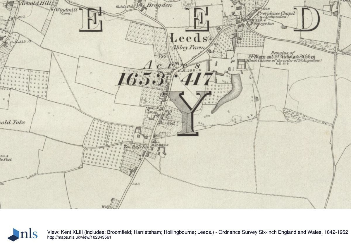
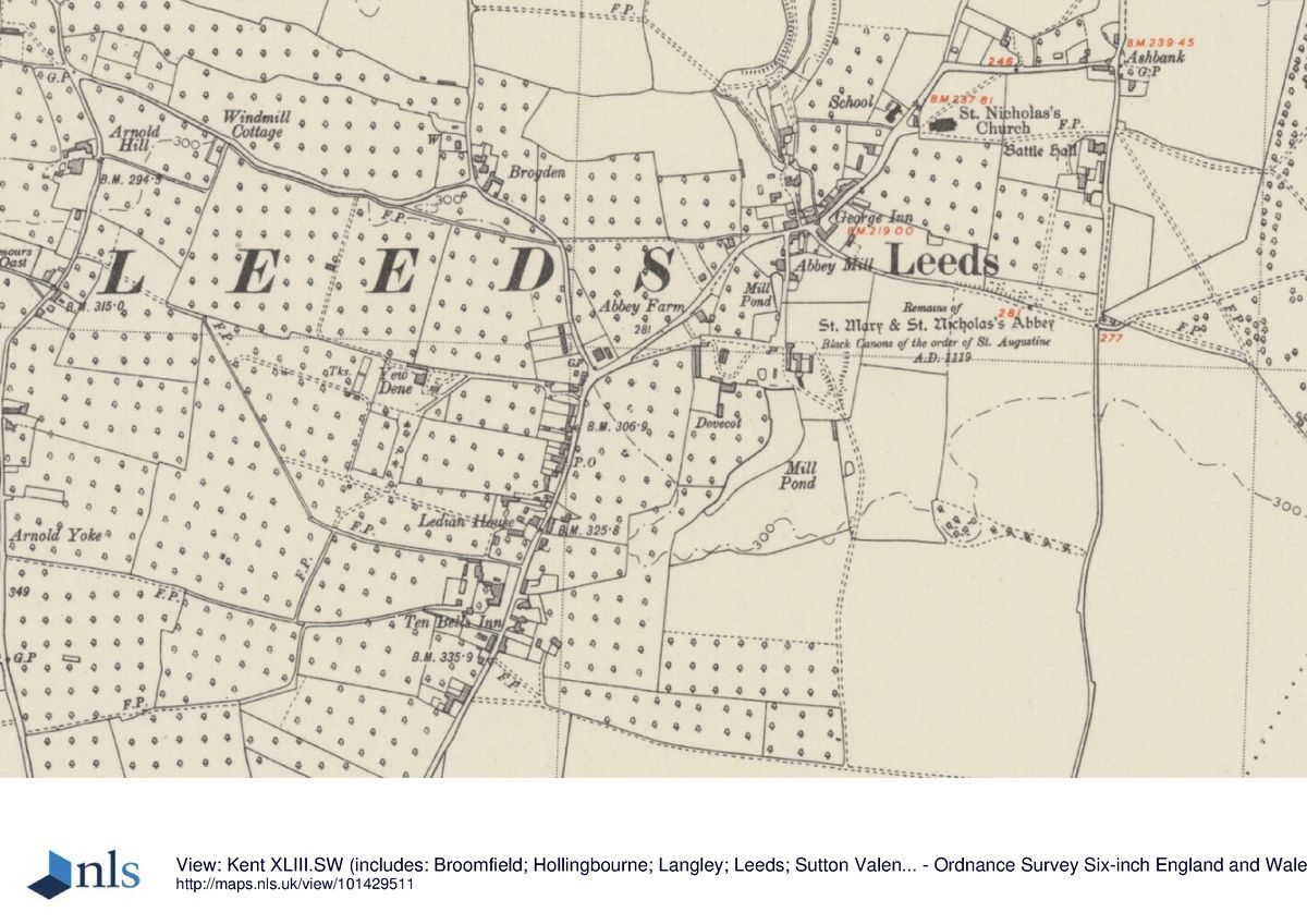
The very roughly rectangular area (c.250m wide x 400m long) is surrounded by farmland to the east and south. To the west are the village playing fields and to the north of this, land belonging to Abbey Farm House. The northern boundary is formed by the garden and pasture adjoining Leeds Mill House. The site, now largely covered with scrub and woodland, slopes gently down on all sides to the small central lake (c.200m in length) which drains northwards from the greensand ridge to form a stream which drove the village mill in medieval times. The remains of the buildings of the priory and the later domestic house lie buried in the north-eastern part of the grounds while disused farm buildings lie to the north-west near the entrance.
ENTRANCES AND APPROACHES
The only entrance to the site at present is through a wooden five-barred gate and along a farm track which opens off the eastern side of Upper Street (B2163) opposite its junction with Forge Lane. The compacted track, following the same line shown on the Hasted map of 1790, runs through rough grassland north-eastwards for 150m to a grassy area surrounded by disused farm buildings.
PRINCIPAL BUILDINGS
The remaining foundations of the priory were investigated by Kent Archaeological Society in three successive summers from 1973-5 (Arch. Cant. vols. 89,91,92,93 and 94) following which Tester commented that it was very difficult to know exactly where the post-dissolution house had been built but the Jacobean front probably stood just south of the position of the nave of the priory church. At the end of the excavation, the site was covered over with earth and the only significant buildings to be seen now (2015) are the two pigeon houses (grade II listed) standing 75m west of the lake and the slype, the sole remnant of the priory and mansion house left above ground (a scheduled ancient monument and grade II listed) standing 30m north-east of the northern end of the lake.
The slype which has a medieval or late medieval core and is rectangular in shape, lies north-south and is approximately 4m x 15m in size. The structure, which appears unstable, is built of coursed ragstone on the western side while the east is of brick on a stone plinth. There are three windows to the east, a doorway in the southern wall and another in the north end of the western wall (Historic Listing). Inside, the brick barrel vaulted ceiling is intact and a photograph of the building (the function of which is not clear) which was published in 1911 shows the roof to have been thatched at that time (The Invicta Magazine).
The pigeon house appears at first sight to be one building but is in fact two, now in a very poor state of repair, no longer with a roof and with large parts of the upper floor missing. The larger northern half was built in the C17 and altered in the late C18. Constructed of brick with ashlar quoins, it is about 6m x 15m with two windows in the eastern wall and a doorway to the north (Historic Listing). The southern end is of similar construction but built in the early C16 and smaller, being only some 6m x 6m with a doorway in the eastern wall and the interior walls lined with nesting areas. It is in a similar state of dilapidation with trees growing inside.
Caiger concluded that the second pigeon house was needed in the C17 when the new mansion was built and there were more mouths to feed. He points out that the Badeslade engraving of 1719 shows no windows in the eastern side of the building and considers that these were later insertions with the addition of a rendering of mortar to suggest stone quoins, a process also used for the northern window and still visible in a photo of 1974 (KAS). He suggests that this was part of the work carried out by Capability Brown in order to disguise the building as a chapel, the name by which it came to be known, which would have stood on the skyline above and to the west of the lake. At the same time this impression was further enhanced by partially separating the two buildings with the creation of a recess in order to improve the proportions which can be seen in a photograph of 1911 (The Invicta Magazine).
GARDENS AND PLEASURE GROUNDS
Access to the site is difficult because it has become so overgrown with scrub and seedling trees which have grown to 10-15m. However the nettles and brambles die down in the winter making access easier at that time. Immediately inside the entrance gate is an area of grass and seedling trees (50m x 50m) surrounded on three sides by disused farm buildings. The southernmost building contains a C16 rubble ragstone wall (grade II listed), 12m long x 1.5m high, which has been built into the wall of the present building. It is suggested that this was part of the priory outbuildings (Historic Listing). Walking through this building and further southwards for 50m across rough ground, the pigeon houses can be reached.
Returning to the entrance, an overgrown track can be found which passes to the north of the farm buildings and leads eastwards for 50m beside a 2m ragstone wall, not listed, that is disintegrating and covered in ivy, marking the way towards the site of the mansion house, priory and the central lake. To the north of the wall an area of rough pasture 200m x 50m extends towards the northern boundary of the site. Continuing further eastwards along the track only the foundation of the wall remains and this extends for a further 100m. At this point, the track meets a path running south-north from the lake which lies 150m to the south. Alongside the western side of the path runs a small stream which formerly carried water from the lake to drive the village mill of Leeds, 120m further northwards. At the junction of the two paths the stream disappears underground through a culvert constructed of ragstone. Neither the line of the stream nor the path can be explored to the north because the area is completely overgrown but the track leading south to the dam is easily followed.
This path follows the western side of the priory site. The excavations of this area during the 1970s were back-filled and are now covered with brambles and seedling trees through which occasional scattered stones are seen. After a further 100m the track passes the slype to the east. This is the only visible remnant of the priory and mansion house and lies at the southernmost point of the archaeological site. 30m beyond the slype, the path reaches the north-east corner of the lake.
The original C18 form of the northern end of the lake survives. It has been formed by digging out the soil and reinforcing the edge with a considerable ragstone wall, c.50m long, forming a dam running east to west from which the land level slopes gently to the north. From roughly the mid-point the stream which flows north to the former mill leaves the lake through a broken sluice. The edge of the lake is fringed with rushes, mature alder and willow beyond which the whole area of Brown's former parkland is covered with a mix of tree species, mostly deciduous. Through these the pigeon houses can just be seen on rising ground to the south-west of the dam.
The lake extends for 200m in a gentle curve to the south-west, eventually narrowing to a point but this is concealed by the western bank thus making it look bigger than it is; a device frequently used by Brown. Although the park has become overgrown, the lake appears to have remained largely unchanged since Brown's time. This can be confirmed by following the historic series of OS maps from the 1799 drawings which show open land surrounding the central lake, with the priory to the north-east, agricultural buildings to the north-west and the pigeon house to the west. Even in 1946 an aerial map (KCC) shows that there was still considerable open land to the east of the lake and that it was only during the second half of the C20 that the trees have grown over the whole site.
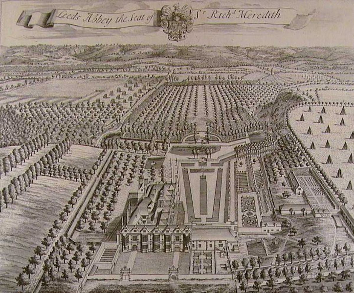
A very different appearance of the landscape is shown in the earlier map of 1769 by Andrews, Dury and Herbert. The buildings of the priory, the house and farm are shown the same position as the C19 maps but the lake is not there. Instead, the elaborate water features shown in both Badeslade's plates occupy centre place. Both images look south to the greensand ridge and differ only in the detail of that part of the garden, a half octagonal pool being replaced by a larger rectangular area of water and the three canals, running north to the house through a sunken garden, have been reduced to a single central one. It was from the southern end that the water features were fed by springs, as the lake continues to be today and as the fish ponds of the earlier monks would have been in medieval times.
Today (2015), to the east of Brown's lake is a plantation of poplar planted perhaps 1940-50, and further east, nearer the edge of the site, are scattered ash, oak, beech and conifer, none of any great age. On the southern perimeter is a belt of beech and to the west a considerable clump of scots pine between the lake and the playing fields. There are, however, five tall sweet chestnuts to the east and north of the lake close to the priory site, perhaps dating from the mid C19 but no older than that. In the same area, the 1911 photograph of the slype shows a large scots pine; probably the same tree which is visible in a photograph in 1974 (KAS). No longer there, this species of tree was used very frequently by Brown as an eye-catcher and perhaps this had been planted as part of his design. It is possible that some of the scots pines scattered about the site are descendants of this tree.
Despite the covering of trees, the shape of the landscape created by Lancelot Brown can still be seen while the lake with its dam is a solid reminder of his skills. Should this land be cleared for further development, much more detail is likely to be revealed.
Detailed description contributed by Kent Gardens Trust 11/05/2016
REFERENCES
Maps
25 inch Ordnance Survey maps, 1st edn. 1868. Sheets 43/9, 43/10, 43/13 and 43/14.
25 inch Ordnance Survey maps, 2nd edn. revised 1895 Sheets 43/9, 43/10, 43/13 and 43/14.
Tithe map, parish of Leeds. 1844. KHLC
Tithe apportionment. 1844. KHLC
Andrews, Dury and Herbert map, 1769. KHLC
Ordnance Survey drawings, 179, British Library
Published Material
Hasted W, The History and Topographical Survey of the County of Kent
Harris J, History of Kent
Archaeologia Cantiana (Arch. Cant.)
Leeds Priory Excavations, 1974 vol. 89, 1975 vol. 91, 1976 vol. 92 (Arch. Cant.)
Tester PJ, The Church, vol. 93. The Claustral Buildings, vol. 94 (Arch. Cant.)
Caiger JEL, Two Pigeon Houses, vol. 89 (Arch. Cant.)
Newman J. The Buildings of England, Kent: West and the Weald.
Fielding CH, Leeds Priory, Invicta Magazine, vol. 2, no. 4, pp. 239-51.
Taylor WS and Pringle JH, eds. Correspondence of William Pitt, Earl of Chatham
Archival Material
Ryder of Rempstone Archive [D/RWR], Dorset History Centre
Roebuck v Calcraft copy bill in Chancery. 1790. D/RWR: L6
Rental of Calcraft estates, Undated, c.1770 D/RWR: E4
Copy will of John Calcraft. 1772 D/RWR: E24
Inventory Leeds Abbey, 1678 U274 F6 Kent History and Library Centre
Description of Leeds Abbey estate, 1739 U274 T89, KHLC
Illustration
Aerial view, 1946, KCC Heritage Conservation Group.
Hugh Vaux,
Virginia Hinze, edit 21 Aug 2015
- History
CHRONOLOGY OF THE HISTORIC DEVELOPMENT
The priory of Leeds in Kent was endowed endowed in the 41st year of Edward III's reign (1367-8) by Robert de Crevequer for the black canons (of the order of St Augustine), ‘giving them a site to build their church upon with other convenient buildings, the former to be dedicated in honour of St Mary and St Nicholas'. The archdeacon of Canterbury claimed the privilege of installing the prior of Leeds and stayed two nights, receiving victuals and drink (Dugdale).
By the reign of Henry VIII the priory was deep in debt but was relieved by James Goldwell, bishop of Norwich, who founded a chantry in the south part of the nave. For his generosity, he came to be looked on as the second founder and, by 1534, the clear revenues of the priory were £362.7s. In this year, the prior, Arthur St Leger, signed the Act of Supremacy and five years later the priory was surrendered to the Crown. ‘The Church, which was equal to some of our Cathedrals in size, was noted for a figure of the Virgin Mary. It had altars to St Katherine, St Martial and St Anne' (Dugdale).
Anthony St Leger, a relative of the earlier prior who had been pensioned off, was granted a lease of the priory lands in the parish of Leeds for 21 years but, at the same time, the king ordered the priory and all the buildings within the precinct to be pulled down. Eventually the site of the priory, with its demesne lands, was settled on St Leger, a total of 229 acres, to be held in capite of the king. The remainder of the estates were settled on the dean and chapter of Rochester, a new foundation of Henry VIII's (Hasted).
For the 50 years following the death of Sir Anthony, as he had become, the estate passed from the St Legers, to the Nordens and then to William Covert. Hasted says that Covert's son who lived there, ‘new built the front of the house, as it now remains, and rebuilt much of the rest of the ancient buildings of the priory'. At the time of writing in the second half of C18, Covert's initials, WC and the date 1598, were still to be seen.
Ten years later (1608), the estate, now known as Leeds Abbey, was bought by Sir William Meredith whose family remained in possession for the next 150 years. More adjoining lands were acquired from the St Leger family in Leeds and the surrounding parishes (Hasted). By 1742, some 750 acres (304 hectares) lying immediately west of the Leeds Castle estate and in the parishes of Leeds and Langley were in their possession (U274 T89, KHLC), of which 30 acres (12 hectares) were the house and gardens.
Sir William's son, also William, was created baronet of Leeds Abbey in 1622 and his son, Richard, eventually succeeded. The latter was a lawyer, Member of Parliament for Kent in the Second Protectorate Parliament of 1656 and member for Sandwich in 1659, becoming second baronet in 1675. On Sir Richard's death in 1679, a detailed inventory of the house was carried out, room by room (U274 F6, KHLC). This is the house whose front was new built by Covert and is shown in a plate drawn by Badeslade, engraved by Kip and included in Harris's History of Kent (1719). This plate is dedicated to Roger Meredith (5th baronet, 1723-1739) but another version of it is dedicated to Sir Richard Meredith (4th baronet) who was Sir Roger's older brother and who died in 1723. The latter plate is probably the older version and shows a different layout to the central part of the garden. Sir Richard had been declared lunatic in 1681 (C211/16/M7, TNA) and, presumably, was incapable of managing his affairs. As it was customary for the owner to pay the expense of preparing the plate, it was probably Roger who paid the bill for the version in Harris, only assuming his title three years later.
Sir Roger, who was a Member of Parliament for Kent 1727-34, married Maria Gott but, following his death in 1738, the baronetcy became extinct because they had no children. Leeds Abbey passed to his niece, Susanna, who continued to live there remaining unmarried. Legal complications and the lack of a direct heir resulted in the estate passing through several hands before being bought by John Calcraft in 1765.
John Calcraft (c.1726-72) had made a fortune first as a pay clerk to the War Office and then as an agent to the army. He was already owner of Rempstone in Dorset and another estate in Kent, Ingress, which he had bought in 1760. While living mainly in London, he was responsible for major works both at Ingress and Leeds which were carried out by Lancelot ‘Capability' Brown. The entry in Brown's account book in the Lindley Library shows that the sums of £300 and £500 were paid by Calcraft for work at Leeds in 1771 and a further £1000 paid the next year by his executors, following his premature death.
Barely 19 years old, Calcraft had married Barbara Ashburn in 1744 only to abandon her shortly afterwards. Although he had two children by George Anne Bellamy, the actress with whom he lived for nine years, his acknowledged heir was his eldest son, John, by his subsequent mistress, Elizabeth McBride. John was only seven years old at the time of his father's death and the estate was managed by Calcraft's executors who included his brother, Thomas, an army officer. The mansion and garden were assessed at a rent of £50 in 1770 by John Calcraft's agent (D/RWR: E4) but seem to have fallen into disrepair and by 1787, when subject of a case in Chancery, the house was said to be ‘worth little more than keeping in repair' (D/RWR: L6). A memorial in the parish church at Leeds was said to have recorded that it was pulled down shortly afterwards in 1790 (Brayley). The lands were subsequently purchased by Charles Wykeham-Martin of Leeds Castle c.1790 for agricultural use before being sold to the present owners, the Rochester Bridge Trust in 1993. The only buildings surviving from C18 or earlier are the two pigeon houses, the slype and a wall incorporated into a present day barn (20C) which is now, in turn, disused.
Detailed history contributed by Kent Gardens Trust 11/05/2016
Period
- 18th Century (1701 to 1800)
- Late 18th Century (1767 to 1800)
- Associated People
- Features & Designations
Designations
Scheduled Ancient Monument
- Reference: The Slype
Features
- Building (featured building)
- Description: The slype which has a medieval or late medieval core and is rectangular in shape, lies north-south and is approximately 4m x 15m in size. The structure which appears unstable, is built of coursed ragstone on the western side while the east is of brick on a stone plinth.
- Pigeon Loft
- Description: There are two pigeon houses standing 75m west of the lake.
- Lake
- Description: The original C18 form of the northern end of the lake survives. It has been formed by digging out the soil and reinforcing the edge with a considerable ragstone wall, c.50m long, forming a dam running east to west from which the land level slopes gently to the north.
- Plantation
- Description: Today (2015), to the east of Brown’s lake is a plantation of poplar planted perhaps 1940-50.
- Wall
- Description: The southernmost disused farm building contains a C16 rubble ragstone wall (grade II listed), 12m long x 1.5m high. It is suggested that this was part of the priory outbuildings (Historic Listing).
- Key Information
Type
Park
Purpose
Agriculture And Subsistence
Period
18th Century (1701 to 1800)
Survival
Part: ground/below ground level remains
Civil Parish
Leeds
- References
References
- Newman, John {The Buildings of England: West Kent and The Weald } (London: Yale University Press, 1976) The Buildings of England: West Kent and The Weald
- Hasted E {The History and Topographical Survey of the County of Kent, Vol. 2} (1782) The History and Topographical Survey of the County of Kent, Vol. 2
- Kent Gardens Trust {Capability Brown in Kent} (Kent Gardens Trust, 2016) Capability Brown in Kent
Contributors
Kent Gardens Trust
Hugh Vaux