Introduction
Hesleyside has a landscape park with the remains of an early formal layout. There is also a walled garden and a mid to late C18 park and designed landscape incorporating features from an early C18 formal layout. .
Terrain
Steep southern range of hills along the North Tyne valley.The following is from the Register of Parks and Gardens of Special Historic Interest. For the most up-to-date Register entry, please visit The National Heritage List for England (NHLE):
Location, Area, Boundaries, Landform and Setting
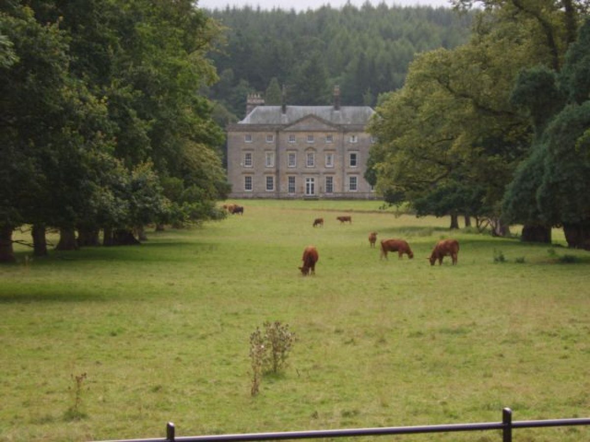
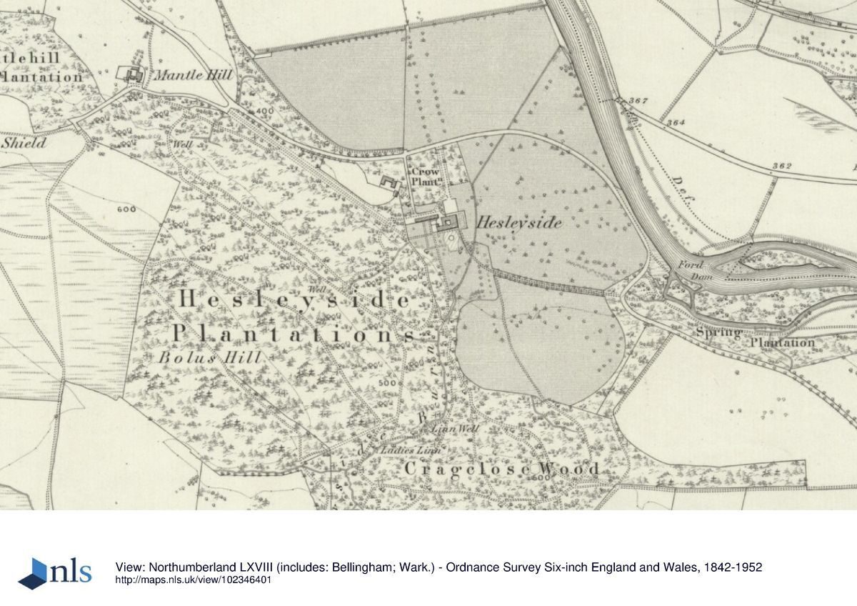
Hesleyside is situated 3km to the north-west of Bellingham, on the south bank of the River North Tyne within the Northumberland National Park. The 85 ha parkland is bounded on the north by the River North Tyne. The inner park, directly to the north-east and north-west of the Hall is marked by remnants of iron parkland fencing along the Bellingham to Kielder road which follows the course of the River North Tyne, and to the south-east by riverside pastures which stretch from the outskirts of Bellingham.
Looking from the park northwards there are contrasting views along the base of the river valley out onto the upper moorland and areas of rough pasture on the north side of the Tyne. To the west and south Hesleyside is sheltered by Hesleyside Plantation and higher moorland.
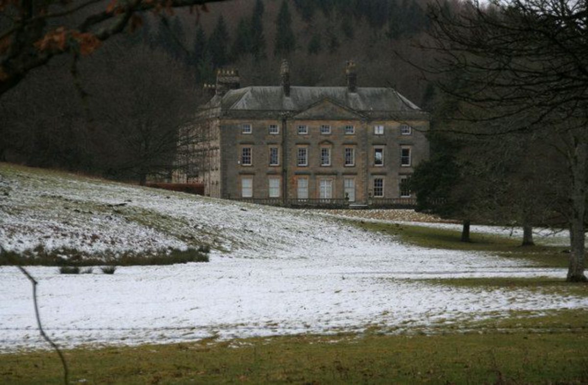
One of the principal views of Hesleyside Hall is from the east when, passing along the public road on the south bank of the river at Spring Plantation, the east front of the Hall appears framed by the east avenue. This east front also forms the view, framed by the avenue and with water in the foreground, as seen from the public road on the north bank of the Tyne when passing along the Bellingham Road, at Cuddies Loup.
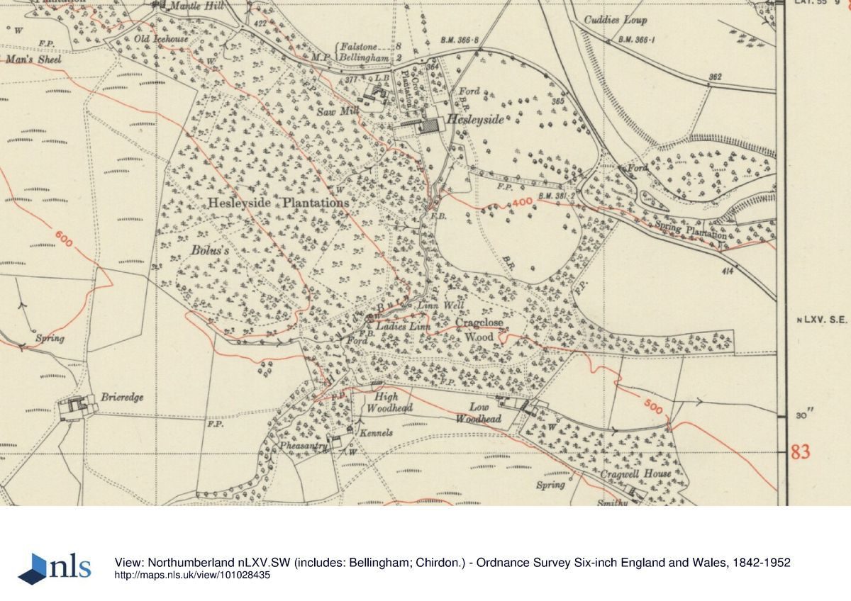
Hesleyside Hall sits directly at the foot of the steep southern range of hills along the North Tyne valley, to the west of the Hesleyside Burn, and is sheltered by higher land on its south-west side. The Burn rises to the south-west of the Hall, falling down through Ladies Linn, and entering the parkland to the south of the Hall. The designed landscape leads radially out from the Hall to the north-west, north, and east, with early C18 formal elements extending towards the river. Views to the south of the Hall extend up the wooded slopes of Cragclose.
Entrances and Approaches
The principal entrance to Hesleyside Hall is 120m to the north of the Hall, where a short drive leads off the public road leading through ashlar gate piers hung with wrought-iron gates set in ashlar walls (early C19, listed grade II), directly to the forecourt at the north, entrance front. The ashlar walls form a formal roadside boundary to the two platoons of trees which flank the drive on its east and west sides, the latter being called Crow Plantation. The short drive leads into the forecourt through ashlar forecourt walls and gate piers (C18, listed grade II) standing 40m to the north of the entrance door.
Further west along the public road, 400 m from the principal entrance there is a secondary entrance to the east of Mantle Hill which leads south-east along a lime avenue (shown on the 1776 plan), then past the south front of the stables to arrive at the gardens on the west front of the Hall.
Principal Building
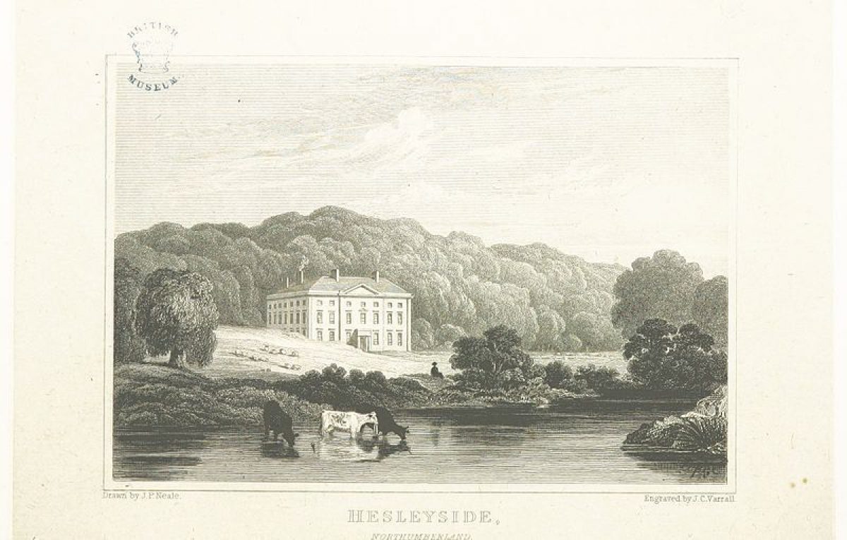
Hesleyside Hall (listed grade II*) is centred on a C14 pele tower, which was extended as a country house in the C17, the remnants of an early C17 loggia arcade with heavily rusticated arches being visible in the courtyard wall. The south front of the mansion dates from c 1719, with the east wing extended by William Newton in 1796-1800. This east wing was then extensively altered in the mid C19.
To the north-west of Helseyside Hall stand the stables (date stone of 1747, remodelled mid C19, listed grade II) and a mill, slightly downslope, on the north side of the Lime Avenue.
Gardens and Pleasure Grounds
The forecourt lies directly against the north front of the Hall; it is screened on its west side by a thick shrubbery set on a raised bed, with stone retaining wall. The formal gardens and lawns around the Hall to the south and east are enclosed within the Hesleyside Burn which has been diverted to lead around the south and east fronts, like a ha-ha.
To the east there is a formal terrace set on a drystone retaining wall, capped by a balustrade with vase balusters and stone urns set at the corners of the terrace (late C18, re-sited mid C19, listed grade II). The balustrade is broken in the centre of the east side to form steps flanked by stone urns on plinths. These steps lead down to a lawn which terminates at the canalised Hesleyside Burn, diverted along a stone-walled channel which separates the formal gardens from the formal avenue which leads out eastwards across the park.
At the south corner of the west lawn (see below) there is a small bridge across the Burn, which is accessible from a path which follows a beech hedge. This appears to have been an earlier formal path leading from the south-east corner of the Hall and across the park in a south-easterly direction to Spring Plantation and then out onto the Bellingham road, set on the shores of the River North Tyne.
A small iron gate leads from the south end of the terrace onto a long paved walk set against the south front of the Hall. A small cascade made along the Hesleyside Burn is visible from the south front of the Hall, terminating the view southwards from the long paved walk. At the west end of the Hall this paved walk rises up along two separate flights of steps to lead out onto the west lawn.
To the south of the Hall a fountain (C18, bought and sited in C20) has been placed centrally on the lawns. The south lawn is enclosed on the east side by the beech hedge and to the west by a yew hedge. As on the east side of the Hall, the lawn is terminated by the canalised Hesleyside Burn and estate fencing is set against the Burn.
To the west of the Hall, two formal garden enclosures laid out against the south side of the offices are used (2000) as flower gardens.
Park
The 1776 plan charts the broad configuration of the landscape as it is today (2000), with three radial avenues focused on the Hall and reaching out into the landscape as follows: on the north front a long formal avenue leading out into the park and forming the central axis to a series of rectangular fields; to the east a broad vista formed through trees focusing on the east front of the Hall; and to the west the Lime Avenue leading up to Mantle Hill. A ride appears to have been laid out parallel to the curving River North Tyne and may represent the course of the unenclosed public road.
The formal avenue on the north front leads through the park which is subdivided into a series of rectangular fields, the present (2000) boundaries matching those shown on the 1776 plan. This avenue leads off northwards from the public road, carrying on the line of the principal entrance drive to the Hall. Nearly mid-way along its length it crosses a deep ha-ha by way of a small stone bridge with ashlar parapet walls and stone coping; views from the bridge leading out westwards focus on the estate farm at Mantle Hill.
The ha-ha (shown on the 1776 plan and probably erected by John Dixon, the Hesleyside agent before 1780) is formed by drystone walling on the south side with a stone-flagged base and silt traps, and also acts as a drainage channel for the marshy ground. This has been cleared and restored (1999).
The east vista leads directly from the boundary of the formal gardens on the east front (the canalised Hesleyside Burn) to the public road, across an area described on the 1776 plan as 'Dovecote Hill'. The vista is lined by an irregular band of mixed deciduous trees and conifers; some replanting has taken place to perpetuate the broad vista.
The Lime Avenue (formed by Tilia europaea), leading from the lawns at the west of the Hall onto the public road at Mantle Hill, has been cleared (1990s) of intrusive species so that it stands out as a major landscape feature.
To the south-west and south Hesleyside Hall is sheltered by Hesleyside Plantation, which extends along the north-east-facing slopes of Mantle Hill to meet Cragclose Wood to the south of the Hall which forms the southern boundary of the park. Much of this area of woodland is made up of old, mature woodland supporting a rich lichen flora, with bryophytes and ferns abundant along the stream.
Spring Plantation, to the south-east of the Hall, is planted along a stream which rises between Hesleyside and Dunterley.
Kitchen Garden
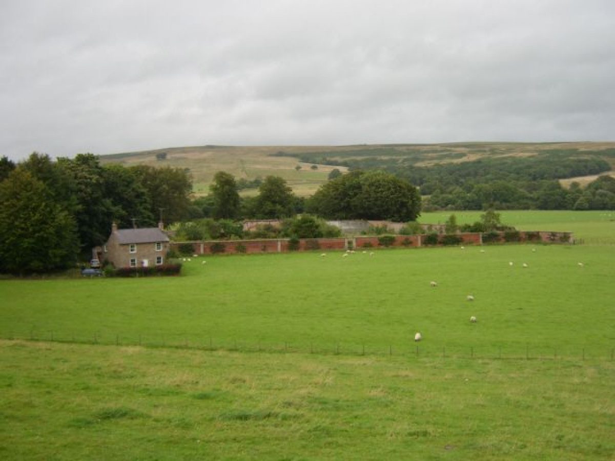
The south-facing walled garden, detached from the main gardens at Hesleyside, is situated to the south of Hesleyside Mill, c 500 m north-west of the Hall. It is associated with the 'Garden House'. This complex is set to the west of the improved fields but is not shown as part of the 1776 improvement plan; it may be C19 in date.
Maps
A Plan of William Charlton Esq's Estate at Hesleyside, 1776 (private collection)
Archival items
The Helseyside Papers are held in a private collection.
Description written: March 2000
Register Inspector: KC
Edited: July 2003
- Visitor Access, Directions & Contacts
Telephone
01434 220 850Website
http://hesleysidehall.co.uk
- History
The following is from the Register of Parks and Gardens of Special Historic Interest. For the most up-to-date Register entry, please visit The National Heritage List for England (NHLE):
17th Century
The park at Hesleyside is laid out around an earlier estate focused on a C14 pele tower owned by the Charlton family. In 1631, during a period of relative peace in the Borders, the pele tower was adapted into a house by adding a two-storey domestic range to the east of the tower.
18th Century
Estate records (private collection) show that Mr William Charlton appointed George Brown to serve as a 'quality' gardener, in October 1715. Their agreement itemises that Brown was to 'put the new modelled garden into good discipline and order according as he shall be directed from time to time, that he shall take especial care of the new planted trees or greens and keep the flower garden neat and handsome'. In addition, under a separate agreement Charlton employed Patrick Ramsay to look after the West Garden, which may refer to a garden to the north of the stables (Estate plan, 1776), to be planted with 'things as may be of most use in the house keeping for the said Mr Charlton's own ' kitchens'. The documents imply that Charlton appears to have been acquiring and enclosing land 'from the tillins' and to have laid out a formal landscape at this time.
Lancelot Brown (1716-83) is traditionally cited as responsible for laying out the gardens and grounds and draining the marshy parks into the Hesley Burn, but there is no firm evidence for this (Archaeologia Aeliana 1960). Family tradition has it that Brown was responsible for the design, but this may be a misconception deriving from the earlier appointment of George Brown in 1715. William Charlton commissioned a plan of his estate in 1776 (unsigned) which shows the estate with a very formal structure and reflects the landscaping done during the early C18 by his predecessor. By 1780 the parkland between the Hall and the river was frequently under water, and a ha-ha had been erected by John Dixon, the Hesleyside agent (Charlton 1949). This series of improvements is probably that shown to the north of the Hall on the 1776 plan, which is still reflected in the field pattern and ha-ha today (2000).
Some late C18 garden features which survive may date to 1796-1800, when the east front of Hesleyside was rebuilt for William Charlton by the Newcastle architect, William Newton (1730-98) (qv Howick Hall, Wallington).
19th Century
Considerable additions to the Hall and gardens were undertaken in the mid C19 when the east range of the Hall was extensively altered and a garden terrace laid out.
The site remains (2000) in private ownership.
- Associated People
- Features & Designations
Designations
The National Heritage List for England: Register of Parks and Gardens
- Reference: GD2049
- Grade: II
Features
- River
- Description: The 85 hectare parkland is bounded on the north by the River North Tyne.
- Plantation
- Description: Spring Plantation.
- Avenue
- Description: East Avenue.
- Burn
- Description: Hesleyside Burn
- Hall
- Description: Hesleyside Hall (listed grade II*) is centred on a C14 pele tower, which was extended as a country house in the C17,
- Formal garden
- Description: Formal gardens and lawns around the Hall to the south and east are enclosed within the Hesleyside Burn which has been diverted to lead around the south and east fronts.
- Fountain
- Description: To the south of the Hall a fountain (C18, bought and sited in C20) has been placed centrally on the lawns.
- Parkland
- Description: Three radial avenues focused on the Hall on the north front a long formal avenue leading out into the park and forming the central axis to a series of rectangular fields; to the east a broad vista formed through trees focusing on the east front of the Hall; and to the west a Lime Avenue
- Kitchen Garden
- Description: South-facing walled garden, situated to the south of Hesleyside Mill, c 500m north-west of the Hall.
- Key Information
Type
Park
Purpose
Ornamental
Principal Building
Domestic / Residential
Survival
Extant
Hectares
85
Open to the public
Yes
Civil Parish
Bellingham
- References
References
- {English Heritage Register of Parks and Gardens of Special Historic Interest}, (Swindon: English Heritage, 2008) [on CD-ROM] Historic England Register of Parks and Gardens of Special Historic Interest
- Stroud, D., {Capability Brown} (London: Faber, 1975) Capability Brown
- Lancelot "capability"; Et Al Brown, (1983) p15 Capability Brown and the Northern Landscape