Introduction
Hartwell House has an 18th-century landscape park, lake and woodland, with 19th-century alterations. The site covered about 85 hectares at its maximum, although parts have now reverted to agriculture. The house is now a hotel. The site was donated to the National Trust by Historic House Hotels in 2008.
Terrain
The land in the garden and inner park close to the house is level, rising slightly to the west, south and east to form a shallow bowl. The land in the outer park is largely level.
The following is from the Register of Parks and Gardens of Special Historic Interest. For the most up-to-date Register entry, please visit the The National Heritage List for England (NHLE):
www.historicengland.org.uk/listing/the-list
Hartwell has an 18th-century landscape park and pleasure grounds, laid out around an early 17th-century country house, with remnants of an early 18th-century formal layout, subsequently naturalised, possibly by Richard Woods. The poet William Mason may have advised on the layout of the flower garden, (now, 1997, gone) in the 1790s.
DESCRIPTION
LOCATION, AREA, BOUNDARIES, LANDFORM, SETTING
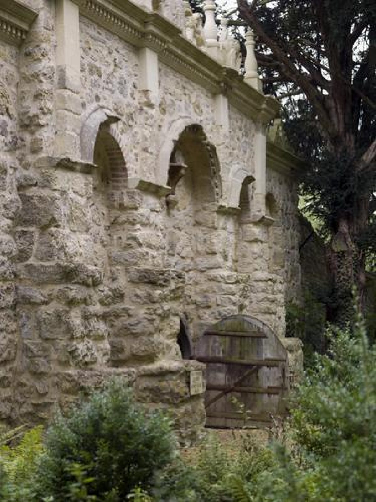
Hartwell House lies in the Vale of Aylesbury, 2km south-west of the centre of Aylesbury, whose suburbs encircle the 85ha site to the north and east. The site's longest, south-east, boundary is formed by a c 2m high rustic stone wall of Portland limestone adjacent to the A418 road. The 2km long wall has large ammonites inserted near the entrance to Lower Hartwell Lane and, nearby, the date 1855 picked out in flint. The area known as Hothouse Piece, containing the kitchen garden and sited at the west end of the site, is entirely surrounded by this wall which also extends north some way down Lower Hartwell Lane, enclosing part of the pleasure grounds. Other park boundaries are mainly defined by fences and hedges bounding adjoining farm land. The park boundary furthest east from the house was originally defined by a brook, but a relief road has been built on the parkland to the west of this feature.
The land in the garden and inner park close to the house is level, rising slightly to the west, south and east to form a shallow bowl. The land in the outer park is largely level. The site is set within agricultural land to the west and south. Immediately between, and covering parts of the two arms of the outer park, is a golf course (c 1995); beyond this are industrial and residential estates of Aylesbury. The pre 1945 agricultural setting to the east, below the high point of Aylesbury and its parish church on the distant hill, has been lost to subsequent development, particularly high rise buildings dwarfing the church spire. Dr John Lee commissioned the Egyptologist Joseph Bonomi Junior to build an alcove called the Egyptian Well (1850, listed grade II) north-west of the house in Lower Hartwell Lane, creating a formal emergence point for the springs which well up here, which is part of the immediate setting.
ENTRANCES AND APPROACHES
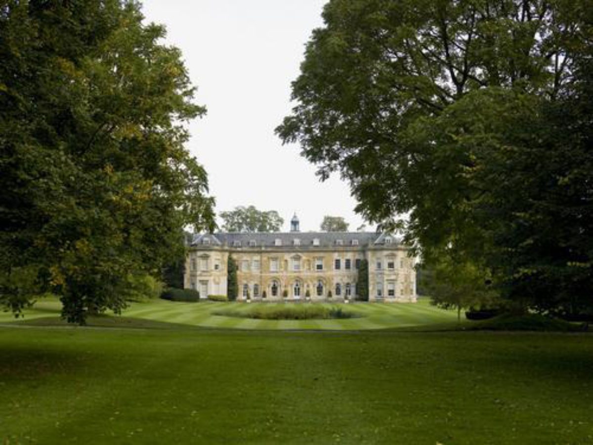
The formal entrance from the A418, south-east of the house, provides access from Aylesbury, and is currently (1997) not in use. The drive leads past the single-storey, rendered Park Lodge (C18, listed grade II) and through a rusticated stone arch flanked by stone piers and short curved screen walls (early C18, listed grade II). The arch was moved twice, in the later C18 and C19, from the gardens en route to its present site; it now heads a straight drive flanked by a lime avenue running north for 300m to give an elevated view west over the inner park to the house. The drive turns west, continuing for 100m and passing over two narrow informal lakes, on either side of part of the old Kew Bridge (James Paine 1782, listed grade II). The Lees installed this central span of old Kew Bridge between the two lakes at the end of the C19, replacing Henry Keene's C18 bridge aligned on the church. The drive turns south-west 100m from the house to approach the north front, with a dominant view of the church to the west and the park to the south, including views of Park Hill column and statue and Gibbs' Ionic Temple. A 1980s' turning circle replaces the earlier forecourt.
The current main approach gives immediate access from the west. This was the service approach before the 1980s, passing through the stable block archway, curving north-east to the north front of the house. In the 1980s the course of this approach was altered to become the main entrance. The drive curves north of the stable block, close to the church, arriving at the north entrance turning circle. The south end of this drive approaches from the A418, along part of Lower Hartwell Lane, dividing the kitchen garden from the pleasure grounds. The lane is largely lined on both sides by a continuation of the stone walls from the main road.
PRINCIPAL BUILDING
Hartwell House (listed grade I) is a rectangular mansion of ashlar stone, with work from various periods from the C17 onwards. It lies towards the southern end of the site, aligned north/south, with the principal entrance on the northern front. This front is the earliest, dating from the early C17. The house was remodelled during successive phases of work in the C18 and C19, with work by Gibbs (c 1740), Henry Keene (c 1760) and possibly James Wyatt (c 1780). It was owned by Dr John Lee from 1829-66, who built an observatory on the south-east corner (now gone), and used the park for festivals of peace and temperance. During the C20 the house suffered some degradation from its institutional occupiers until a major restoration was carried out in the late 1980s and the house became a hotel. The main view east towards Aylesbury parish church, although now somewhat obscured and degraded by modern development around the church, still exists, opening out in the eastern outer park. It is still visible from the upper, east-facing rooms in the house, through the shelter belt between the inner and outer east park.
The rubble-stone and ashlar stable block and attached coach house (C18, listed grade II*) lie 50m south-west of the house; they now contain a fitness centre and accommodation and are prominent in the approach from Lower Hartwell Lane. The building incorporates parts of the menagerie attributed to Gibbs, shown in paintings of 1738 by Balthazar Nebot (Harris 1979), to which the stables were attached, probably by Richard Woods in the 1760s (E Throssell pers comm, July 1998).
GARDENS AND PLEASURE GROUNDS
The garden surrounds the house and is largely laid to lawn. Some garden buildings survive from the early C18 formal phase and several have been moved, including Gibbs' rusticated arch, now at the park entrance adjacent to Park Lodge. Those still within the garden include Gibbs' Gothic Tower (James Gibbs 1730, listed grade II) 150m north-west of the house, once part of The Wilderness, and the church of St Mary (Henry Keene 1753-5, listed grade II*). This Gothic-Revival church lies on a mound 75m west of the house in a dramatic position within the landscape, close to the site of an older church. The new church concluded a vista from the house and was aligned on Gibbs' canal temple and Keene's later bridge (both now gone).
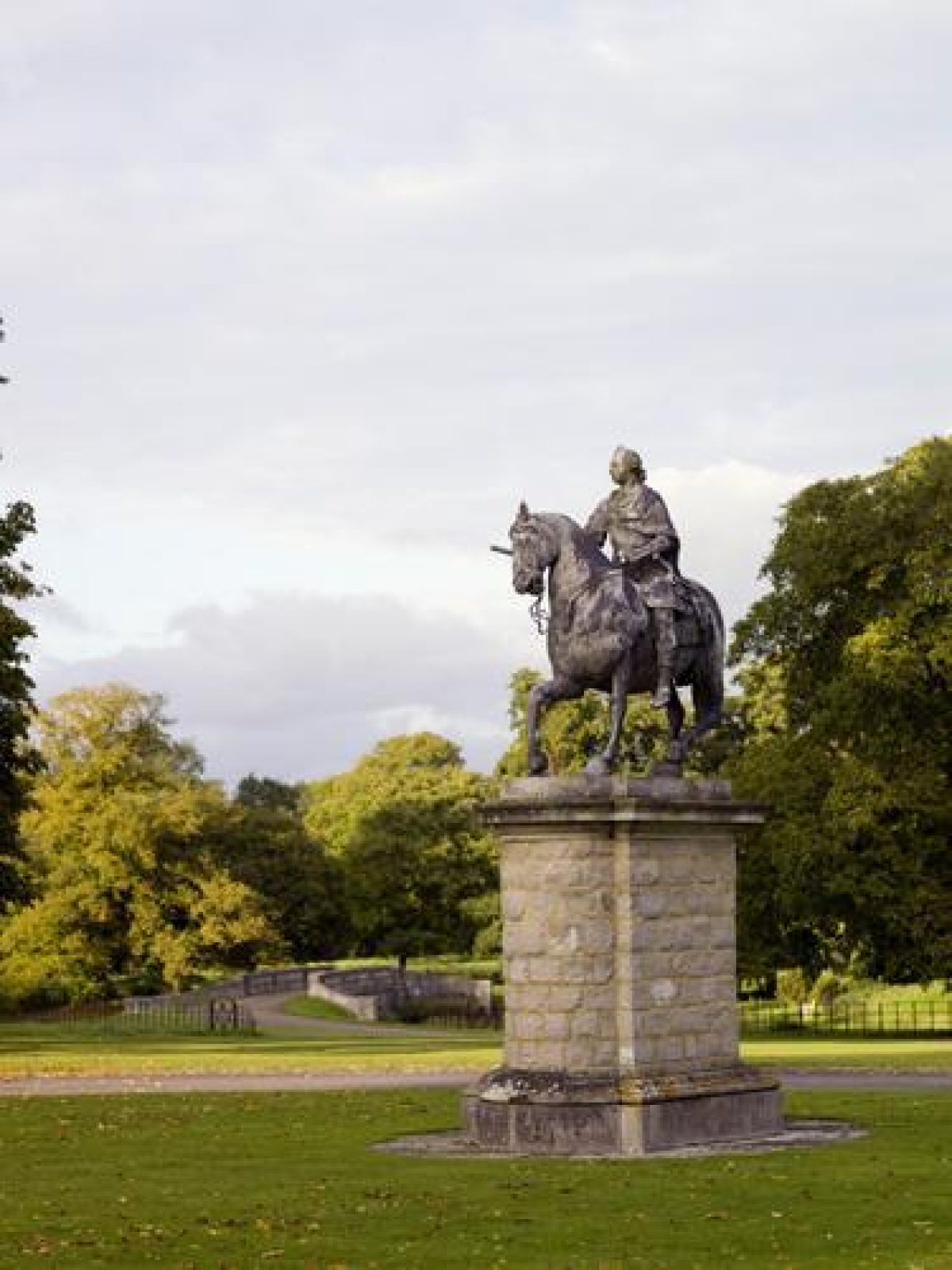
The area north of the house has been extended in the late C20: the ha-ha was moved further north and instead of the brick wall a sunk fence was installed. A turning circle was created in front of the main entrance to the house and the lead equestrian statue of Frederick, Prince of Wales (John Cheere 1757, listed grade II*) was moved from the garden south-west of the house to the middle of the grass turning circle, blocking the long view from the front door along the North Avenue.
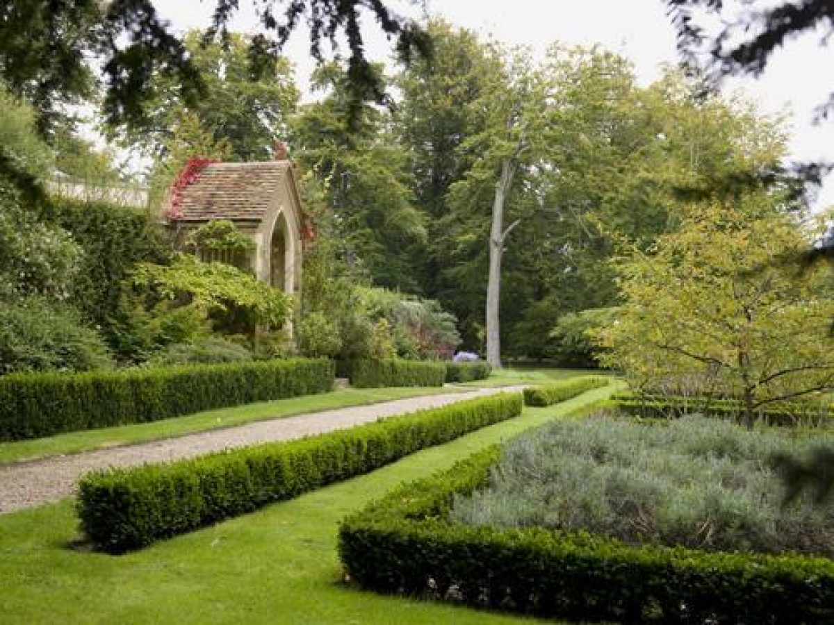
East and south of the house the garden is laid to lawn, with shrub beds and trees. Hartwell was let to the Comte de Provence (later Louis XVIII) between 1809 and 1814, this occupation being commemorated by a group of clipped yews east of the house, originally crown- and mitre-shaped, which survive in modified form. A central circular pond with an island, 75m south of the house, has recently been remodelled and replanted. A ha-ha separates the garden's east and south boundaries from the park. The garden south-west of the house is crossed by paths, with scattered mature trees. A small gothic summerhouse known as the Dairy (C18, listed grade II) is inserted into part of the garden wall south of the stable block. The ha-ha at the extreme south-west garden boundary was moved further south in the 1990s to incorporate part of the park into the garden and create a car park. The new structure contains a sunk fence.
In the 1690s Sir Thomas Lee, second Baronet, created a formal topiary garden in the Dutch style. Work in the gardens seems to have recommenced in 1723 for Sir Thomas, the third Baronet, when one James Neale submitted a proposal for making a reservoir near the stables, to provide a 20' fountain in the gardens, for £40 (BRO). This heralded a major development period. The formal C17 features seem to have been used as a frame for many other buildings and garden features in a formal scheme of gravel and turf allées, avenues, geometrical ponds, hedges, yew arcades and screens cut with tall arches and elaborate topiary. Many of the buildings of this period are derived from Gibbs' Book of Architecture (1728), to which Sir Thomas subscribed. The 1738 series of eight paintings by Nebot shows the garden in minute detail, as it probably existed. A further painting of 1757 (possibly by William Hately) (Harris 1979) shows a transitional period when the garden was in the process of being naturalized. The third Baronet may have commissioned these paintings to commemorate the completion of this phase of the gardens. Lady Elizabeth Lee may have invited the poet William Mason (1725-97) to advise at Hartwell in the 1790s, adding shrubberies and meandering paths to the south-west and south-east of the house (Garden History 18, 1990). A set of sixteen sketch plans for flower beds in the 1790s (in the Bodleian Library, Oxford) may have been influenced by Mason. These beds are not visible.
PARK
The c 20ha inner park surrounds the garden to the north, east and south. It is laid to pasture, with belts and clumps of trees and two lakes, and contains: the Ionic Temple known as The Cott (James Gibbs c 1730, listed grade II*) 200m south-east of the house, with four flanking terms (early C18, listed grade II) which formerly lay by the circular pond south of the house; Park Hill Statue and Column (Thomas Watts early C18, listed grade II) 150m east-south-east of the house; the icehouse (1760s, listed grade II) 150m north-east of the house; and the obelisk (? James Gibbs early C18, listed grade II) 200m south of the house, although the obelisk's two flanking statues (early C18, listed grade II) are now to the east of the stable block. An avenue has been replanted in the 1990s between the ha-ha and the obelisk south of the house. There are still paths through the belt known as Beech Walk adjacent to the A418 boundary to the south-east. The double North Avenue begins c 75m north of the house, running north for c 200m, then continuing north in the outer park for c 1.75km; it was partially replanted in the early 1990s.
The outer park, largely divided from the inner park by fences on its north and east boundaries, consists of two separate areas attached to the north and east edges of the inner park. That to the east has partly become a golf course. Beyond this is pasture with areas of ridge and furrow and park trees. The belt along the A418 boundary to the south-east, a continuation of Beech Walk to the south-west, is important in screening the park during the approach from Aylesbury. Another, narrow, belt of trees flanks the south side of the road, creating an informal avenue. The park north of the inner park contains the North Avenue and is largely agricultural: a mixture of pasture and arable. The double avenue of mixed, largely native species is being restored as part of a long-term replanting scheme, although several portions still consist of mature trees. At the north end of the avenue the line of trees changes direction slightly to run almost exactly north/south. This is aligned on the mill buildings at the far northern end of the avenue, which are not themselves ornamental. Part of the golf course crosses the avenue at the north end and also runs down the east side of it.
The park dates from the mid to late C18. A major reordering of the grounds occurred following the succession of the fourth Baronet, Sir William Lee, in 1754. It is likely that Richard Woods (1716?-93) carried out much of this work, taking the grounds from a formal garden layout to parkland. He is known to have worked at Hartwell for thirty-five days in 1759-60, supplying a large order of ornamental shrubs and trees during this period (Harvey 1974, 204(7). He also supplied a design for the 'New Garden Greenhouse and Pinery' (BRO). During this period a ha-ha was built on all but the west side of the house, the tunnel through the rustic bridge became the route under the main drive to the kitchen garden and surrounding pleasure grounds, and Keene designed his bridge aligned on the church (finished in 1780 by Wyatt).
KITCHEN GARDEN
The kitchen garden, the brick walls of which appear to be Victorian, lies west of the house, within an area of pleasure grounds called Hothouse Piece, isolated from the gardens and park by Lower Hartwell Lane and surrounded by its own section of the 1850s' park wall. It is approached from the south via the garden by a tunnel through a rustic bridge, with rustic stone arches at either end (probably Richard Woods 1765, listed grade II). The bridge seems to have been free-standing when built, although it is now flanked by the park walls. Included within the structure and ornamenting the parapets of the bridge are masonry and stone ornaments removed in the mid C18 from the north front of the house. The kitchen garden is narrowly rectangular and houses tennis courts. A line of yews is planted along the lane adjacent to the rectory. The western half of Hothouse Piece is woodland, enclosing a bowling green, at the east edge of which stands the Bowling Green Pavilion (reconstructed 1997). The gardener's cottage (C17/C18, listed grade II) lies in the south corner of this area.
REFERENCES
Country Life, 9 (8 June 1901), pp 740-747; 35 (14 March 1914), pp 378-384; 165 (15 March 1979), pp 707-709; no 47 (22 November 1990), pp 68-72
J Harvey, Early Nurserymen (1974), pp 204-207
J Harris, The Artist and the Country House (1979), pp 188-189, pl 20
Garden History 14, no 2 (1986), pp 89, 91; 15, no 2 (1987), pp 124, 134; 18, no 2 (1990), pp 103-154
J Garden History 8, nos 2 & 3 (April-September 1988), p 229, pl XIII
N Pevsner and E Williamson, The Buildings of England: Buckinghamshire (1994), pp 374-378
Maps
Vol of Estate papers of Sir William Lee, 1777 (D/X1045/1), (Buckinghamshire Record Office) [14 plans after Inclosure: Map 1 includes mansion house, pleasure grounds and land adjacent]
Inclosure map for Hartwell parish, 1777 (Buckinghamshire Record Office)
Hartwell estate map, 1837 (Buckinghamshire Record Office)
OS 6" to 1 mile: 1st edition published 1885
2nd edition published 1900
3rd edition published 1922
OS 25" to 1 mile: 1st edition published 1881-1882
Archival items
Estate papers at Buckinghamshire Record Office including: Garden proposals by James Neale, 1723 (D/LE/A2/1.p.4); design for 'New Garden Greenhouse & Pinery' by Richard Woods 1759-1760 (D/LE/11.p.10).
Description written: 1997
Amended: April 1999
Edited: June 1999
- Visitor Access, Directions & Contacts
Telephone
01296 747444Owners
The National Trust
Heelis, Kemble Drive, Swindon
- History
The following is from the Register of Parks and Gardens of Special Historic Interest. For the most up-to-date Register entry, please visit the The National Heritage List for England (NHLE):
www.historicengland.org.uk/listing/the-list
HISTORIC DEVELOPMENT
Hartwell House was probably built by Sir Alexander Hampden between 1570 and 1617, around the site of a medieval building. In the early 17th century the house and estate passed to the Lees of East Claydon and Moreton, in whose possession they remained for 300 years.
After his father's death in 1690, Sir Thomas Lee, 2nd Baronet, created a formal topiary garden of which nothing appears to survive. The 2nd Baronet died in 1702, when his 15-year-old son, also Thomas, inherited the estate. The 3rd Baronet developed his father's garden during the second quarter of the 18th century, and development of the landscape continued during the 19th and early 20th century.
Hartwell was acquired by Ernest Cook in 1938, and used as an army billet during the Second World War, subsequently becoming a girls' school. It became the property of the Ernest Cook Trust in 1952. In 1979 Sir Geoffrey Jellicoe produced a landscape renewal scheme. Hartwell is occupied by Historic House Hotels, who were responsible for the restoration of the house and grounds from 1987 to 1992. A golf course has been constructed over part of the outer park and agricultural setting to the north and east.
Period
18th Century (1701 to 1800)
- Associated People
- Features & Designations
Designations
The National Heritage List for England: Register of Parks and Gardens
- Reference: GD1098
- Grade: II*
Style
English Landscape Garden
Features
- House (featured building)
- Description: The house was built on the site of a medieval building.
- Earliest Date:
- Latest Date:
- Temple
- Obelisk
- Column
- Canal
- Exedra
- Description: Yew tree exedra.
- Pavilion
- Arch
- Description: Triumphal Roman arch.
- Orchard
- Kitchen Garden
- Key Information
Type
Park
Purpose
Ornamental
Principal Building
Commercial
Period
18th Century (1701 to 1800)
Survival
Extant
Hectares
85
Open to the public
Yes
Civil Parish
Aylesbury
- References
References
- {English Heritage Register of Parks and Gardens of Special Historic Interest} (Swindon: English Heritage 2008) [on CD-ROM] Historic England Register of Parks and Gardens of Special Historic Interest
- Pevsner, N and Williamson, E {The Buildings of England: Buckinghamshire} (London: Penguin, 1994) pp 374-378 The Buildings of England: Buckinghamshire
- Throssell, Eric {Hartwell: The flower garden of Lady Elizabeth Lee} (2005) Hartwell: The flower garden of Lady Elizabeth Lee
- Related Documents
-
CLS 1/1028
Notes for a seminar on flowers and flower gardens in 18th C landscape garden
unknown - 2006
-
CLS 1/1028