Introduction
Harrington Hall has formal gardens of two hectares, which include a walled kitchen garden and a 17th-century terrace. The house is privately owned but the gardens are open to the public a few times a year.
www.historicengland.org.uk/listing/the-list
Seventeenth- and 18th-century gardens within a 19th-century park form the setting for a country house of medieval origin which was rebuilt and added to in the 17th, 18th, 19th, and 20th centuries.
DESCRIPTION
LOCATION, AREA, BOUNDARIES, LANDFORM, SETTING
Harrington Hall and its park, comprising c 25ha, lie within the village of Harrington, 3km north-east of the village of Hagworthingham, 2.5km south-east of the village of Somerby, and c 7km north-west of the town of Spilsby. Part of the unclassified road from Hagworthingham forms the western boundary of the site. At the north-west corner of the park this road meets the road from Somerby and continues eastwards as part of the northern boundary. The northern boundary of the site here registered continues south of Harrington village and St Mary's church to Hall Wood. The eastern boundary is formed by the outer edge of Hall Wood in the north and abuts farmland in the south-east. The southern boundary is formed by part of an unclassified road running eastwards from the Hagworthingham road. The setting is rural.
ENTRANCES AND APPROACHES
The main entrance is from the north-west, between red-brick gate piers topped with ashlar moulded coping and surmounted with single decorative urns (mid C18, listed grade II), 150m from the Hall. The drive leads south-eastwards and crosses a stream which runs into a small pond 100m west of the Hall. The gravel drive continues to a large turning circle with a central lawn and arrives at the west front of the Hall. To the south-west of the drive and running parallel to it is a brick ha-ha. On the survey map of c 1680 the drive led east off the Old Road, the area west of the Hall that became the present turning circle being shown planted with trees. The line of the present drive matches that on the Tithe map of 1839 and by 1891 (OS) the turning circle is shown.
PRINCIPAL BUILDING
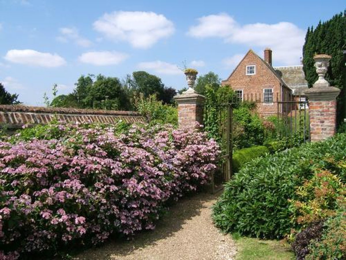
Harrington Hall (listed grade I), built of red brick with a slate roof, has two storeys plus attics, thirteen bays, and a central three-storey porch. Attached to the north end of the main Hall is a two-storey, three-bay wing. The Hall, of medieval origin, was remodelled in the early C16 and rebuilt in the 1680s for Vincent Amcotts whose architect may have been William Catlyn of Hull (Pevsner et al 1989). The north wing, which was added in the C18, was rebuilt in 1902 (J Architectural Conservation 1998). Following a fire in 1991, Harrington Hall was restored in the early 1990s.
Immediately north-west of the Hall are the L-shaped stables, brick built with tiled roofs; these were also rebuilt in 1902 (ibid).
GARDENS AND PLEASURE GROUNDS
The gardens lie to the south of the Hall. They consist of a garden of 0.25ha, walled on three sides, the east wall shared with the kitchen garden, the south wall buttressed on the outer side, and the west wall forming the east wall of a terrace walk. The north side of the garden abuts a gravel path which runs westwards from the south front, south of the turning circle. South of the gravel path is a wide shrub bed. Set in the south wall is a small shelter with a tile roof. The central lawn of the garden is edged with borders planted with shrubs and flowers abutting the walls.
Steps set between ashlar gate piers lead from the gravel path on the north side of the garden westwards up to the raised terrace walk (terrace, garden and court walls, listed grade II), built of red brick and some ashlar and paved with brick. The terrace runs from north to south and is planted on either side with small shrubs and herbs. There are views out west and south-west over the parkland and east into the walled garden.
On the survey map of c 1680 the line of the raised terrace is marked with trees planted east of the terrace and a small building at the east end of the planted area. The terrace could be Elizabethan as at Loseley in Surrey (CL 1974) or C17, and is possibly built with rubble from the old house (Pevsner et al 1989).
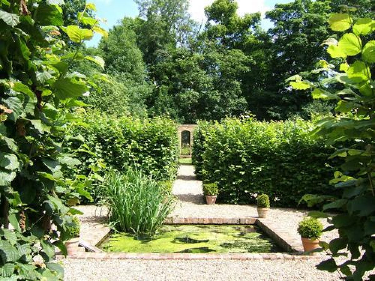
South of the walled garden is an area enclosed by hedges and ornamental trees from which there are views out over the park. It contains a tennis court and is laid out with shrub borders. A path, with a wild flower meadow to the north, leads from the northern end of the enclosed area past the south wall of the kitchen garden and continues north-east through Hall Wood to the southern end of a 180m long canal or pool. This runs from north to south through the east side of the Wood, a path from the kitchen garden crossing the water via a causeway 30m from the southern end. The woodland is a mixture of limes and other deciduous trees of varying ages with wild flowers as ground cover. There are remains of walks around the canal (D Price pers comm, 2000).
The map of c 1680 shows the canal as divided into three pools with Wood Close to their east and a 'Grove' to the west. By 1839 (Tithe map) the two northernmost pools had been joined.
PARK
Harrington Hall is sited in the north-east corner of the park. The park is crossed by a footpath which runs southwards as a spur off the main drive, west of the small pond and west of the forecourt, and continues to the south-east corner of the park following the line (or approximate line) of the 'Old Road' as marked on the c 1680 map. The road was moved westwards to its present line in 1723. East of the footpath the park is scattered with trees and further east is the southern end of the L-shaped Hall Wood.
On the map of c 1680, the area south-west of the Hall and west of the 'Old Road' which was to become the west park, was divided into fields, as was that to the east. This remained the case in 1839 (Tithe map ) but by 1891 (OS) the whole area was imparked.
KITCHEN GARDEN
The walled kitchen garden (mid C18, listed grade II) comprising c 0.5ha lies immediately east of the east front of the Hall. The gate piers and walls are built of red brick and ashlar. There is a low retaining wall between the east front of the Hall and the garden, separated from the Hall by a gravel path. Stone steps lead from the east front up to the garden and a grass path leads eastwards across the garden. The rectangular garden is laid out with a copper beech to the north and beyond it fruit trees on the south-facing north wall. On either side of the path, to the north are quartered plots edged with box and to the south the square plots have a central square also edged with box. The plots are planted out with vegetables and fruit. Prunus hedges run from east to west south of the quartered plots with two conical yews at the eastern end. A high yew hedge runs along the east end of the southern edge of the garden. C20 greenhouses and storage sheds stand on the southern edge of the garden. The gardener's cottage, brick built with a tiled roof, lies 120m south-east of the Hall.
The c 1680 map shows a long canal east of the Hall and west of the Grove, towards the eastern edge of what is now the kitchen garden. By 1839 (Tithe map) the canal had been divided into one long pool and three small ones; by 1891 the canals had gone (OS).
REFERENCES
W White, Directory of Lincolnshire (1856), pp 728-9
Kelly's Directory (1937)
H Thorold and J Yates, Lincolnshire, A Shell Guide (1965), p 75
Country Life, 156 (4 July 1974), pp 18-21; 177 (2 May 1985), pp 1180-2; no 34 (22 August 1996), pp 36-9; no 35 (29 August 1996), pp 26-31
J Anthony, The Gardens of Britain 6, (1979), pp 92-3
N Pevsner et al, The Buildings of England: Lincolnshire (2nd edition 1989), pp 631-2
Evening Telegraph, 7 January 1992 N Field, Harrington Village Survey, preliminary report, (1993)
Journal of Architectural Conservation, no 1 (March 1998), pp 21-41
H Thorold, Lincolnshire Houses (1999), pp 61-4
C Sturman, Arthur Eden and Harrington Hall, (no date)
Maps
J Speed, The Countie and Citie of Lyncolne described with the Armes of them that have bene Earles thereof since the conquest, 1610
A true and exact survey of Harrington in the County of Lincoln for Vincent Amcotts, Esquire, around 1680 (Lincolnshire Archives)
Tithe map for Harrington parish, 1839 (Lincolnshire Archives)
OS 6" to 1 mile: 1st edition surveyed 1886?7, published 1891; 2nd edition published 1906
OS 25" to 1 mile: 2nd edition published 1906
Description written: August 2000
Edited: June 2002
- Visitor Access, Directions & Contacts
- History
The following is from the Register of Parks and Gardens of Special Historic Interest. For the most up-to-date Register entry, please visit the The National Heritage List for England (NHLE):
www.historicengland.org.uk/listing/the-list
HISTORIC DEVELOPMENT
In the Domesday Survey of 1086 Ivo Taillebois had a manor in Archintone which may have been Harrington (Field 1993). In the 13th and 14th centuries the de Harringtons lived at Harrington and by 1346 John de Harrington was the owner. By the late 14th century Harrington had passed by marriage to the Copledykes. The house may have been remodelled in 1535 (Country Life 1974). In 1673 Vincent Amcotts (1625-86) purchased it and he remodelled Harringon in the 1680s (CL 1974). On the death of the last of the Amcotts, Charles, in 1777, the estate passed to his niece, the wife of Sir John Ingleby of Ripley Castle, Yorkshire. Their second daughter, Augusta Amcotts Ingleby married Robert Cracroft (1783-1862) who let the Hall. It continued to be let into the early 20th century until it was sold to Major Thomas Jessop around 1920. After threat of demolition the Hall was sold in 1927 to Major W H Rawnsley of Well. By 1937 Holliday Hartley was the owner (Kelly's Directory). During the Second World War the Hall became a home for Dr Barnardo evacuees from Sheffield (Evening Telegraph 1992). In 1950 Sir John Maitland, MP for Horncastle, purchased the Hall and grounds. The Hall was sold in 1991 and there was a fire later that year. The Hall has since been restored and remains (2000) in private ownership.
- Features & Designations
Designations
Area of Outstanding Natural Beauty
- Reference: Lincolnshire Wolds
The National Heritage List for England: Register of Parks and Gardens
- Reference: GD1981
- Grade: II
Features
- Terrace
- Earliest Date:
- Latest Date:
- Croquet Lawn
- Herbaceous Border
- Kitchen Garden
- Pond
- Manor House (featured building)
- Description: The house was re-modelled in the 17th, 18th, 19th, and 20th centuries.
- Latest Date:
- Key Information
Type
Garden
Purpose
Ornamental
Principal Building
Domestic / Residential
Survival
Extant
Hectares
25
Civil Parish
Harrington
- References
References
- {English Heritage Register of Parks and Gardens of Special Historic Interest}, (Swindon: English Heritage, 2008) [on CD-ROM] Historic England Register of Parks and Gardens of Special Historic Interest
- Anthony, J., {The Gardens of Britain 6: The East Midlands} (London: Batsford, 1979), pp. 92-3 The Gardens of Britain 6: The East Midlands
- Pevsner, N. and J. Harris, {The Buildings of England: Lincolnshire} (London: Penguin, 2nd edition 1989), pp. 631-2 The Buildings of England: Lincolnshire