Introduction
Forde Abbey is an early-18th century formal gardens and landscape, remodelled in the late-19th century with extensive plantings. The gardens, of around 10 hectares, were restored and developed from the mid-20th century onwards. They lie within about 23 hectares of parkland.
Terrain
The ground ascends gently from the River Axe on the northern boundary up to the minor road forming the southern boundary of the site.The following is from the Register of Parks and Gardens of Special Historic Interest. For the most up-to-date Register entry, please visit The National Heritage List for England (NHLE):
Late 19th and 20th century gardens and pleasure grounds incorporating elements surviving from an early 18th century formal scheme.
Location, Area, Boundaries, Landform and Setting
Forde Abbey is situated c 3.5km south-east of Chard, and c 2km north-west of Thorncombe. The c 33ha site comprises some 6ha of formal gardens and pleasure grounds, and c 27ha of parkland. To the east the site is bounded by a minor road, Park Lane, while a further minor road forms the southern boundary. The River Axe forms the northern boundary, and to the west the site adjoins agricultural land. The ground ascends gently from the River Axe on the northern boundary up to the minor road forming the southern boundary of the site, and there are northerly views from the park, across the gardens and pleasure grounds, to agricultural land and woodland to the north of the River Axe. There are also westerly views across farmland which retains elements of ornamental planting from late C19 and early C20 parkland (OS 1890) (outside the registered area).
Entrances and Approaches
Forde Abbey is approached from Park Lane to the east, at a point c 50m south of the bridge which carries the road over the River Axe. The entrance is marked by a pair of late C18 Ham stone piers surmounted by large carved stone urns, which supports a pair of early C20 wrought-iron gates (all listed grade II). The carriage entrance is adjoined on each side by pedestrian gates which are supported by a further pair of stone piers (listed grade II).
Beyond the entrance a straight tarmac drive extends c 190m south-west through an avenue of mature limes, before emerging and continuing for a further 50m south-west between clipped yew hedges. The drive terminates in a gravelled terrace below the eastern end of the south facade of the house, while a spur leading north-north-west below the east façade provides access to the mid C17 stables (listed grade II), which stand c 50m north of the house; the late C20 visitors' car park north of the kitchen garden; and the forge and other estate buildings west of the house. This drive continues c 100m west beyond the forge before turning sharply south and extending c 500m south-south-east parallel to the western boundary of the site, to reach an early C20 lodge and entrance situated on the minor road forming the southern boundary of the site. Opposite this entrance, which is situated at the south-west corner of the site, a further drive and early C20 avenue leads south to Forde Abbey Farm (outside the area here registered).
The north-east drive from Park Lane corresponds to that recorded on the late C19 OS map (1890), while one of Edmund Prideaux's early C18 views shows a straight formal drive and avenue approaching a pair of gates at the south-west corner of the house. This arrangement appears to correspond to the drive which survives today, although the planting has been renewed in the late C19 or early C20.
Principal Building
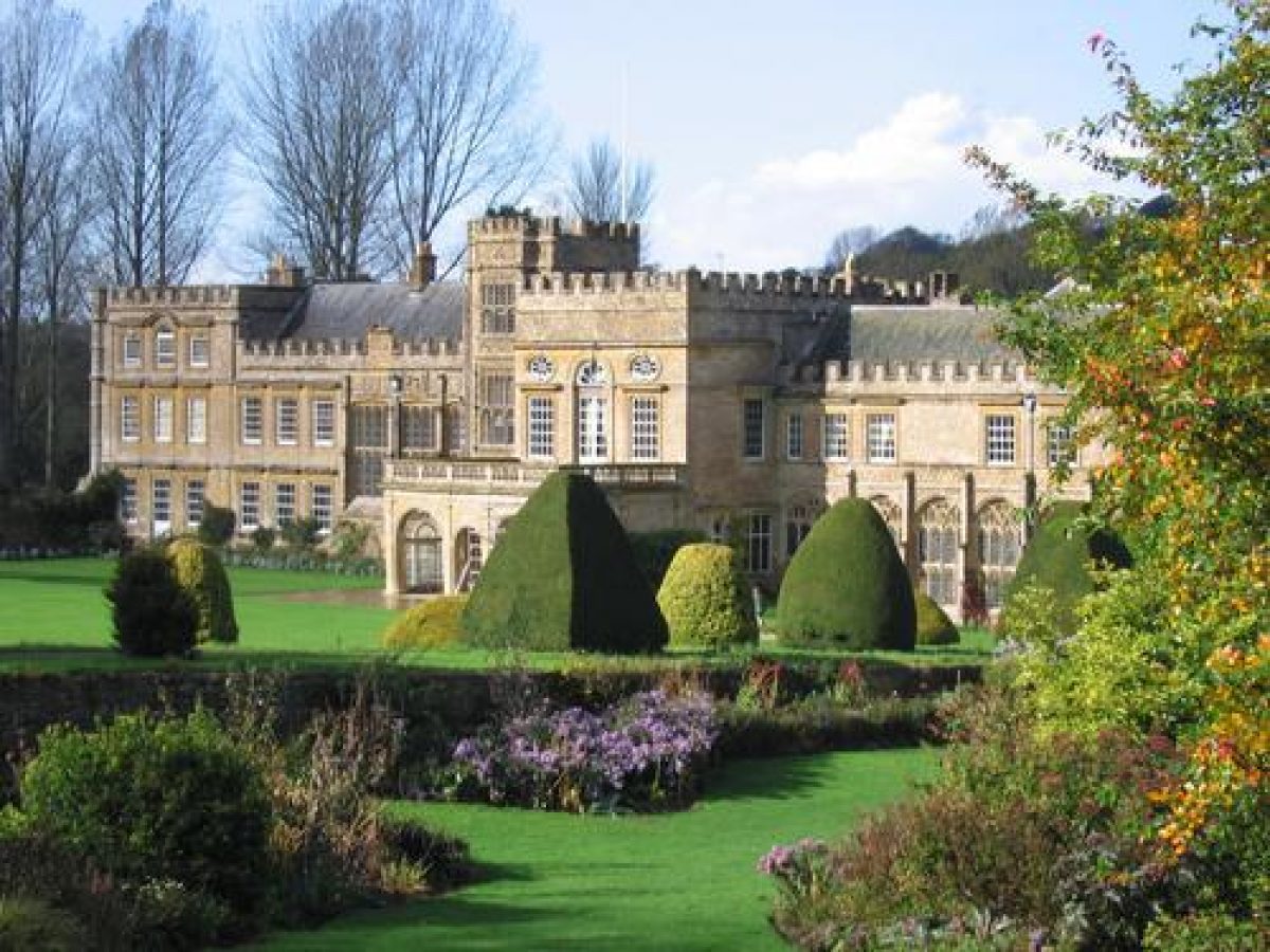
Forde Abbey (listed grade I) stands on level ground c 150m south of the River Axe which forms the northern boundary of the site. The house is constructed in rubble stone with Ham stone ashlar and dressings under slate and lead roofs. It has an irregular plan, with the principal range running north-east to south-west, and a further range to the east of the principal range extending to the north-west and south-east, forming a 'T' shape on plan. The principal or garden facade is to the south, and is terminated at its eastern end by the chapel, which projects forward from the line of the facade. The chapel was converted from the mid C12 monastic chapter house. To the west of the chapel, the north side of the early C16 cloister survives as a glazed corridor, while further west the facade incorporates a three-storey porch tower, and four monumental mullion and transom windows lighting the great hall. These elements, together with the cloisters, were constructed by Abbot Chard, who was forced to surrender the house to the Crown in 1539. The south facade is terminated to the west by a three-storey block which incorporates medieval material, but was remodelled in the late C17 or early C18 to balance the chapel to the east. The north façade is irregular in construction with many short projecting gabled wings, while the projecting north-west wing comprises two storeys and is of plain construction. This wing was converted from the C13 dorter.
The remains of the medieval monastic buildings which were incorporated into Edmund Prideaux's late C17 house range in date from the mid C12 to the early C16. Abbot Chard undertook extensive improvements immediately prior to its dissolution in 1539, some of them remaining incomplete at the surrender (Oswald 1959). The abbey church, together with the east, west, and south ranges of the cloisters, which lay to the south of the present house, were demolished after the Dissolution. The late C17 and early C18 work carried out for Prideaux, and completed for Sir Francis Gwyne, was traditionally attributed to Inigo Jones (1573-1652), but it is now ascribed to a London builder, Peter Mills (d 1670), who worked for several of Prideaux's colleagues holding high office under the Protectorate (Oswald 1959; CL 1963). Few changes were made to the late C17 house until a programme of restoration was undertaken by Mrs Bertram Evans after 1864, and again in the early C20 by the Roper family.
Gardens and Pleasure Grounds
Formal gardens are situated to the south and south-west of the house, with areas of informal pleasure grounds to the south-west, beyond the formal gardens, and to the south-east of the house.
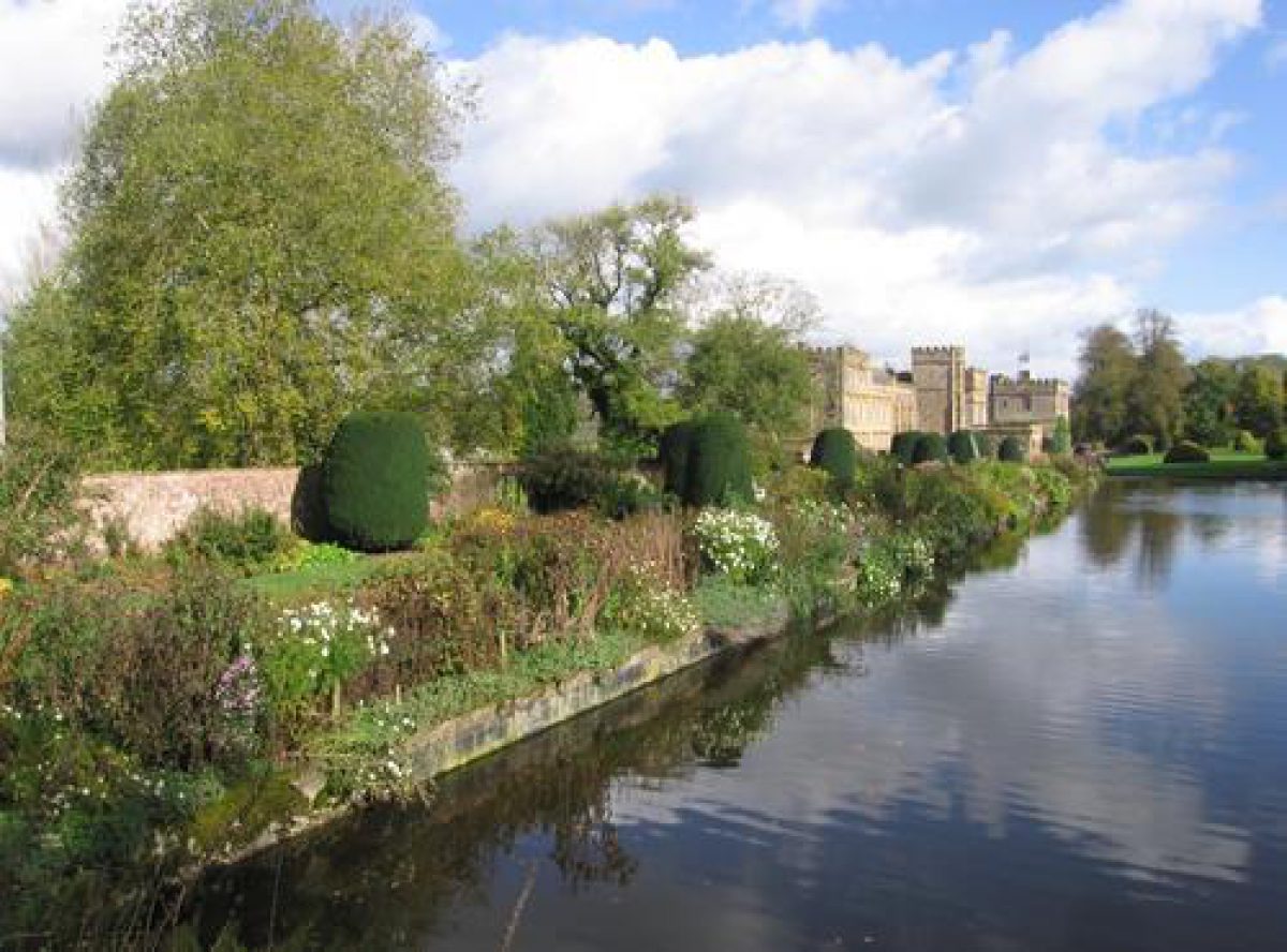
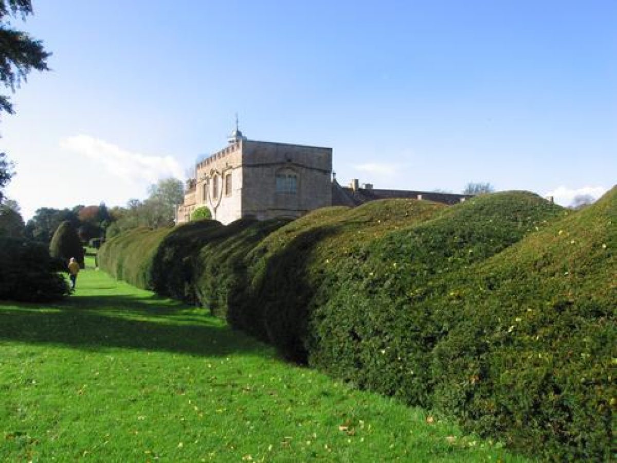
A gravelled terrace continues the axis of the north-east drive, passing below the south facade of the house for c 50m to reach Abbot Chard's C16 entrance porch. To the south of the house an approximately rectangular level lawn extends c 50m, occupying the site of the monastic church and cloister (Oswald 1959). The lawn is enclosed to the south, east, and west by a grass bank and terrace, the terraces to the east and west being planted with alternate drums and cones of clipped green and golden yew. To the south of this lower lawn, a further rectangular lawn extends c 80m to a stone ha-ha which allows a wide view across the park. A gravel perimeter walk encloses the lawn, which is adjoined to the east by an early C20 rock and water garden laid out in a dell which also contains an icehouse (OS 1890), and to the west by the Wilderness. The lawns to the south of the house appear to correspond to those shown by Edmund Prideaux in two of his 1727 views, and criticised by the Rev Swete in 1794 for their 'old style' (Gray 1995). The terraces are recorded on the OS map of 1890, but the specimen topiary, while clearly inspired by Prideaux's views, appears to have been planted in the late C19 or early C20.
The axis of the south terrace is projected further west by a lawn and a grass walk which leads c 200m west to a statue and a C19 or early C20 wrought-iron clairvoie screen. The walk is enclosed to the north by an C18 brick wall, beneath which a C20 herbaceous border extends for c 130m. To the south the walk is adjoined by a rectangular canal extending c 100m from east to west. To the west, the canal is terminated by a bank on which stands a late C20 tempietto, from which a cascade descends to the pool. A further rocky cascade marks the mid-point of the grass bank which forms the south side of the canal. The long walk corresponds to a feature delineated by Prideaux in 1727; it was also noted by the Rev Swete (1794), at which time it was planted with irregularly spaced limes and beech giving the appearance of `a noble avenue¿ (Gray 1995). The canal, and the cascade on its south side, were also recorded by Prideaux in 1727, at which time the canal was adjoined to the south by topiary and high hedges which enclosed the Wilderness. The canal was not mentioned by the Rev Swete in 1794 (ibid), but it is shown on the 1864 sale plan; by the late C19 it had been filled in (OS 1890). The OS map of 1930 shows that the rectangular outline of the canal survived, while the cascade discharged into an octagonal pool. The canal was restored in the mid C20 by Geoffrey Roper (Oswald 1959).
The canal forms the lowest of four linked water features which ascend the north-facing slope to the south-west of the house. Immediately above the canal, an approximately elliptical pool, the Mermaid Pool, is enclosed by scattered specimen trees and evergreen and ornamental shrubbery. To the east, the pool is overlooked by a simple pergola comprising four stone columns supporting timber beams. A cascade, emerging from an C18 ashlar arch, enters the pool at the head of an inlet on its southern side. The elliptical pool and cascade appear to correspond to features of the Wilderness recorded by Prideaux in 1727, while in 1794 the Rev Swete noted `a large piece of water of an oval figure¿, around which `an orangine was formed during the summer months' (Gray 1995).
Above the elliptical pool the gently sloping ground is planted with scattered specimen trees and conifers, and groups of ornamental shrubs. Some 40m south-south-east of the elliptical pool, a small rectangular pool is fed by a stepped cascade which descends a steep, north-facing wooded bank which forms the retaining dam of the Great Pond, an approximately square body of water. A late C20 arbour of clipped hornbeam overlooks the Great Pond from the dam, while to the west of the pond a late C20 bog garden has been developed. The Great Pond is shown in approximately its present form on the 1864 sale plan.
To the east of the Great Pond is an area of lawn planted with scattered specimen trees and conifers. Some 100m north-north-west of the Great Pond, a grass bank appears to indicate a former extension of the ha-ha enclosing the southern side of the south lawn. To the north of this bank is a further area of lawns and ornamental planting, enclosed to the west by a brick wall which extends south-south-east from the clairvoie at the western end of the south terrace walk. To the north of these lawns, a more wooded area south of the terrace walk is planted with a collection of camellias and rhododendrons. An informal grass walk leads north to reach the western end of the terrace walk.
An arboretum has been developed since the mid C20 to the east of the rock garden, c 100m south-east of the house. In 1864 (Sale plan) this area lay within the park.
Park
The park is situated principally to the south of the house, with further areas of paddock located to the north-east, adjacent to the drive.
The south park comprises a gentle north-facing slope which becomes increasingly undulating towards the south-west boundary. The park remains pasture (2004) with scattered specimen trees and ornamental clumps. An early C20 avenue of limes extending c 450m south-south-east through the park is aligned on the south facade of the house. The avenue replicates a feature recorded by Prideaux in 1727, at which time a park, grazed by deer, was separated from the gardens around the house by a post and rail fence. The C18 avenue is not shown on the 1864 sale plan, although the OS map of 1890 appears to show remnants of formal axial planting in the park.
A further area of park or paddock is situated to the north-east of the house and north of the drive. This area, bounded to the north by the River Axe, remains pasture (2004) and is divided into paddocks by fences. It is crossed from east to west by a service drive leading from Forde Bridge to the stables. A slightly curved pool c 50m long is situated immediately south of the service drive, c 20m south-west of the service entrance from Park Lane. The area to the north-east of the house is identified on the 1864 sale plan as the Bowling Green, and is shown enclosed to the north by a much longer pool, identified as the Canal Pond. Edmund Prideaux's 1727 view shows a rectangular level meadow or lawn to the north-east of the house, apparently enclosed by a hedge to the north, with an arbour at its north-west corner.
Kitchen Garden
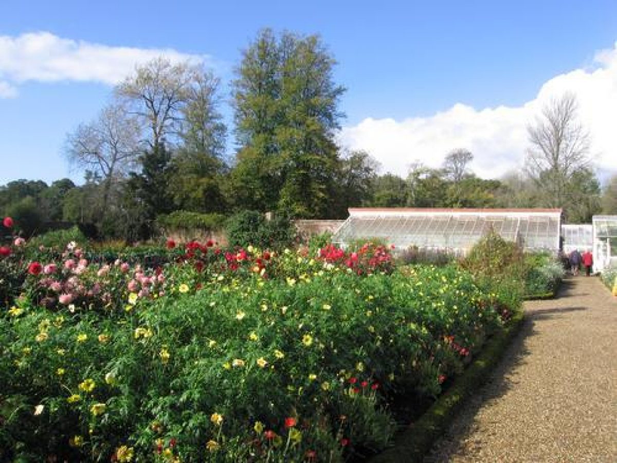
The kitchen garden is situated immediately north of the house, from which it is separated by a narrow yard. The garden comprises two unequal compartments and is enclosed by C18 brick walls c 3m high (listed grade II). The larger, southern compartment has a cruciform arrangement of gravel walks dividing box-edged planting beds. The north to south walk is aligned to the south on a wrought-iron gate which is in turn aligned on a garden door on the north facade of the house. The garden retains some wall-trained fruit trees, together with C19 glasshouses constructed against the inner face of the north-west wall. A C19 lean-to peach house stands to the north-east. The smaller, northern compartment is today (2004) used as a nursery and plant sales area. It retains a further range of glasshouses and frames against the inner face of the north wall. A triangular-shaped walled yard situated to the west of the northern compartment is now used as a visitors' reception area.
The kitchen garden is shown in its present location on the 1864 sale plan. The plan shows a cruciform layout to the southern compartment, together with the range of glass to the north-west. The garden is shown adjoined to the east by a rectangular poultry yard; this area had been incorporated into the kitchen garden by the late C19 (OS 1890). The 1864 plan similarly shows a truncated northern compartment, with a range of glass along its north wall. The plan also shows the triangular-shaped yard to the west of the northern garden. The area of orchard shown on the late C19 OS map (1890) to the north of the kitchen garden was developed in the late C20 as a visitors' car park.
REFERENCES
S and N Buck, Buck's Antiquities I, (1774), pl 63
Country Life, 7 (24 March 1900), pp 368-374; 26 (3 July 1909), pp 18-26; 133 (14 March 1963), pp 540-543; (21 March 1963), pp 596-599; (28 March 1963), pp 656-659; (4 April 1963), pp 714-717; 134 (12 September 1963), pp 586-590
A Oswald, Country Houses of Dorset (2nd edn 1959), pp 113-118
N Pevsner and J Newman, The Buildings of England: Dorset (1972), pp 208-211
T Gray, The Garden History of Devon (1995), pp 106-108
Maps
- Sale particulars, 1864 (DD/CN box 32/9), (Somerset Record Office)
- OS 6" to 1 mile: 1st edition surveyed 1887, published 1890
- 1930 edition
- OS 25" to 1 mile: 1930 edition
Illustrations
- Edmund Prideaux, four drawings of Forde Abbey, September 1727 (private collection) [copies on EH file]
- S and N Buck, engraved view of Forde Abbey, c 1774 (published in Buck 1774)
- Rev J Swete, three watercolour views of Forde Abbey, 1794 (564M, F7, 81, 109), (Devon Record Office)
Archival items
- Estate records, including garden accounts 1728¿1818, and the sale particulars of 1864, are held at the Somerset Record Office (DD/CN).
Description written: June 2004
Amended: December 2004
Edited: May 2005
- Visitor Access, Directions & Contacts
Telephone
01460 221290Website
https://www.fordeabbey.co.ukAccess contact details
The gardens are open daily throughout the year. The house is open with the exception of Saturdays and Mondays from 12 until 4.
Directions
The estate is 4 miles east of Chard, signposted from the A30, A358 and B3165.
Owners
Geoffrey and Diana Roper
Forde Abbey, TA20 4LU
- History
The following is from the Register of Parks and Gardens of Special Historic Interest. For the most up-to-date Register entry, please visit the The National Heritage List for England (NHLE):
www.historicengland.org.uk/listing/the-list
HISTORIC DEVELOPMENT
In 1136, Richard de Redvers, Earl of Exeter founded a daughter house of the Cistercian house at Waverley, Surrey at Brightley, near Okehampton. This community was transferred to Forde in 1141 (Oswald 1959; Pevsner and Newman 1972). The house was dissolved in 1539, and its estate was subsequently granted to Richard Pollard, son of Sir Lewis Pollard of King's Nympton Park, Devon. The estate changed hands several times in the early 17th century, and in 1649 it was sold to Edmund Prideaux, Attorney General under Oliver Cromwell, who incorporated substantial elements of the medieval monastic buildings into a mansion (Country Life (CL) 1963). When Prideaux died in 1702, Forde was inherited by his daughter, Margaret, and her husband, Francis Gwyne, Secretary at War to Queen Anne, who completed the rebuilding of the house and developed formal gardens around the new house. The house and garden were recorded in a series of drawings by Edmund Prideaux (d 1745) in 1727 (private collection). These show formal lawns surrounded by topiary trees to the south of the house, a canal and cascade partly enclosed by high hedges to the south-west of the house, and an axial vista extending through parkland to the south.
Between 1814 and 1817 Forde was let to Jeremy Bentham, the writer on jurisprudence (1748-1832), who entertained J S Mill (1806-1873) in the house (CL 1963). Following the death of the last member of the Gwyne family in 1846, Forde was purchased by G F W Miles, the son of a Bristol merchant and brother of Sir William Miles of Leigh Court, Somerset. It was sold again in 1864 to Mrs Bertram Evans, who bought it on behalf of her two sons. Mrs Bertram Evans was in turn succeeded by her son, Herbert Evans, and, in 1906, by her great-niece, Mrs Freeman Roper. Forde Abbey remains (2004) the property of the Roper family.
Forde Abbey was formerly situated in Devon.
- Features & Designations
Designations
The National Heritage List for England: Register of Parks and Gardens
- Reference: GD1708
- Grade: II*
Features
- Tree Feature
- Description: Arboretum.
- Temple
- Description: Ionic temple.
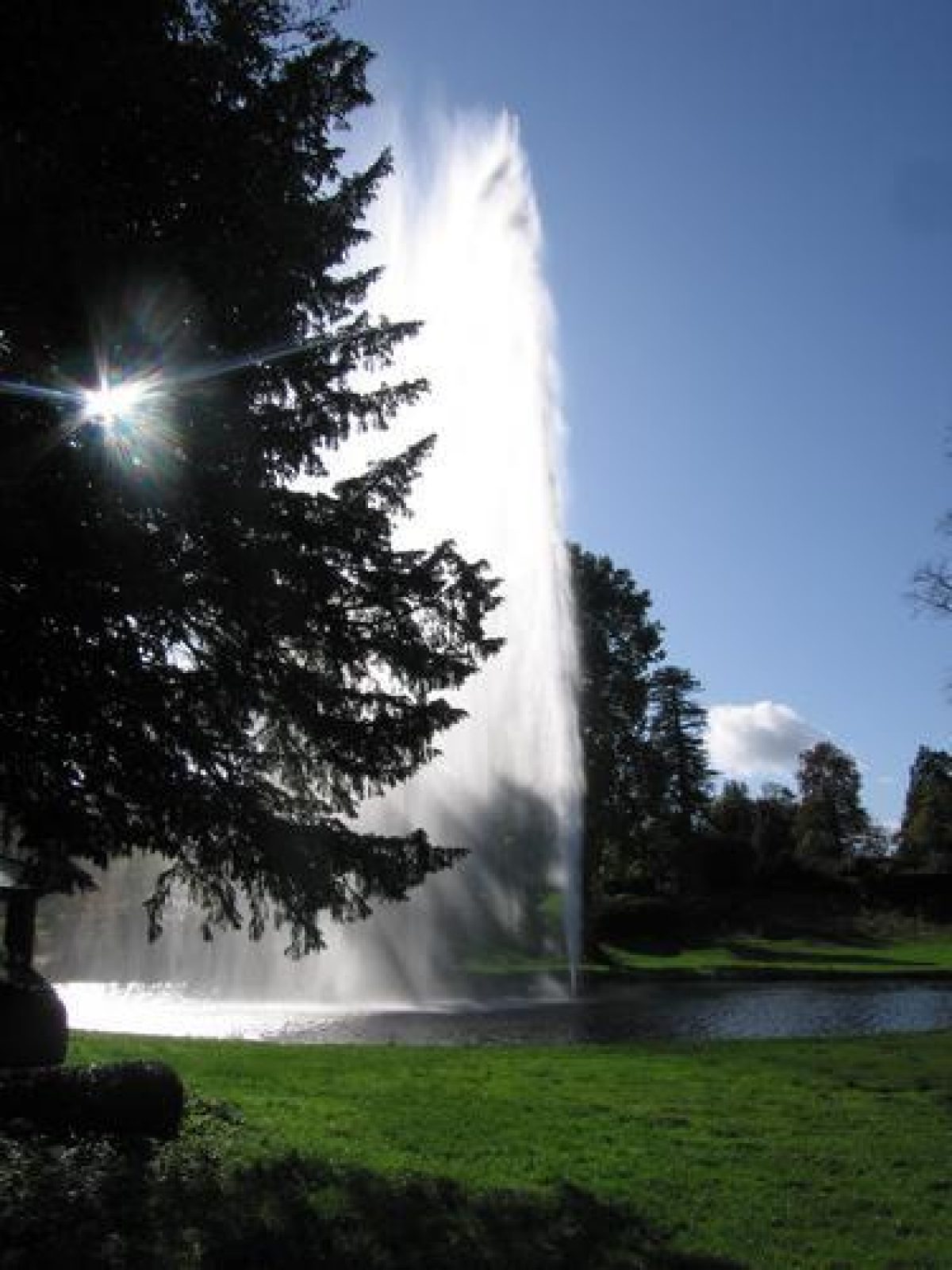
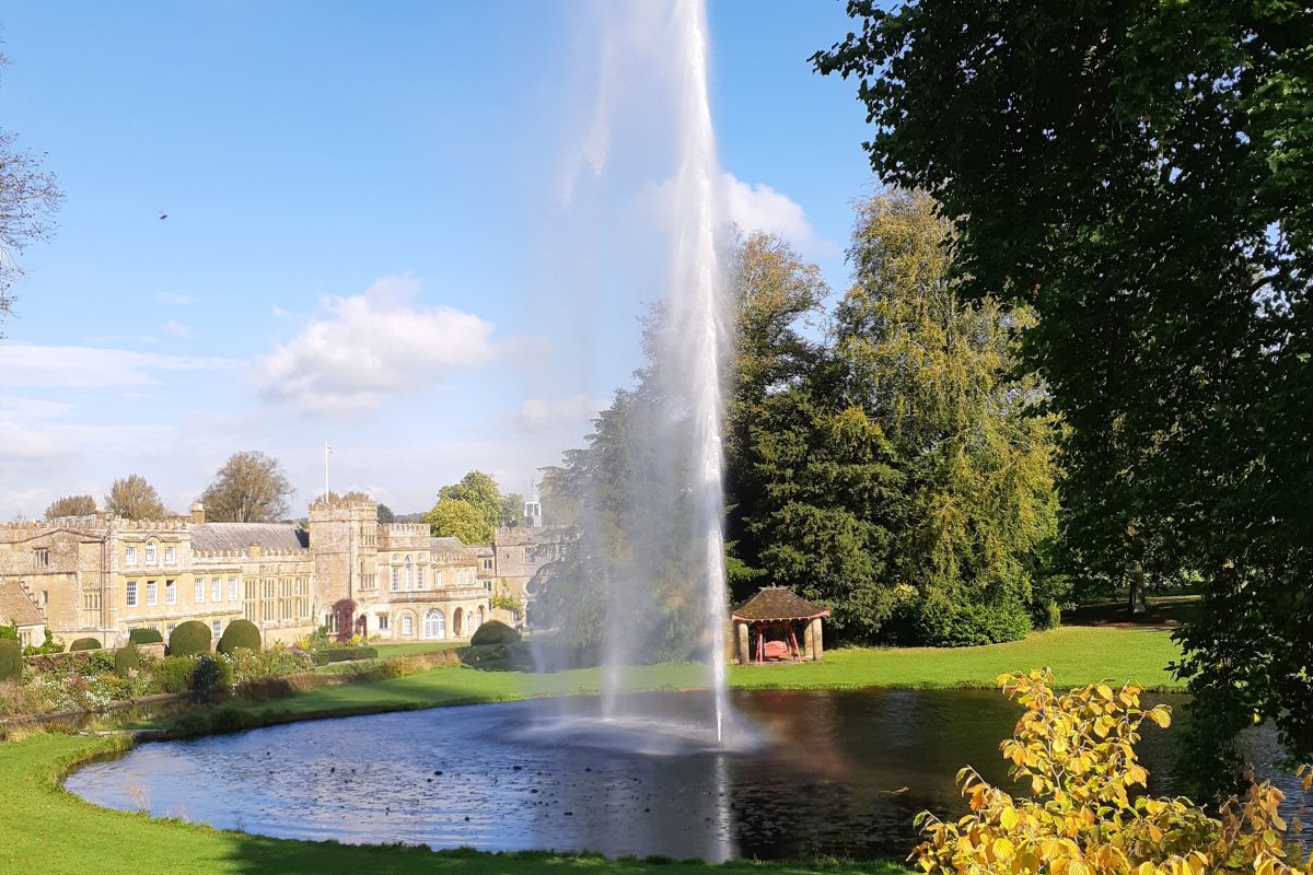
- Fountain
- Description: Centenary fountain.
- Cascade
- Formal garden
- Parkland
- Key Information
Type
Estate
Purpose
Ornamental
Principal Building
Domestic / Residential
Survival
Extant
Hectares
33
Open to the public
Yes
Civil Parish
Thorncombe
- References
References
- Newman, J and Pevsner, N {The Buildings of England: Dorset} (Harmondsworth: Penguin, 1972) pp 208-211 The Buildings of England: Dorset
- Oswald, A {Country Houses of Dorset} (2nd edn 1959) pp 113-118 Country Houses of Dorset
- {English Heritage Register of Parks and Gardens of Special Historic Interest} (Swindon: English Heritage 2008) [on CD-ROM] Historic England Register of Parks and Gardens of Special Historic Interest
- Gray, T {The Garden History of Devon} (1995) pp 106-108 The Garden History of Devon