Introduction
Cricket House has terraced gardens of around half a hectare dating from the late-17th to early-18th centuries. There are also pleasure grounds and a park of around 225 hectares, dating to the late-18th to early-19th centuries. The house is now a hotel and is only open to hotel guests.
Terrain
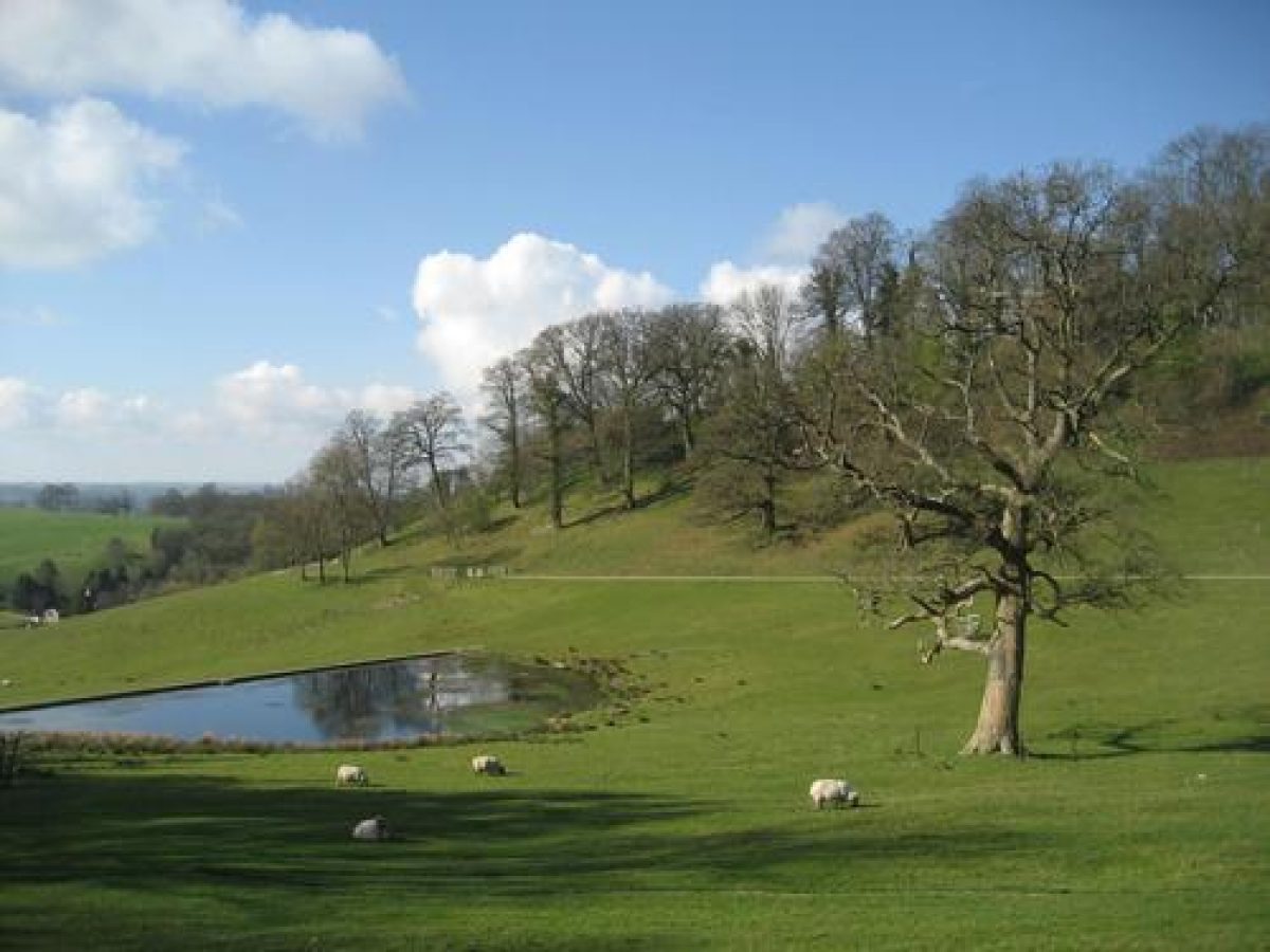
The site comprises the valley of a stream, a tributary of the River Axe, which flows from north-east to south, and which is dammed to form a chain of lakes.
The following is from the Register of Parks and Gardens of Special Historic Interest. For the most up-to-date Register entry, please visit The National Heritage List for England (NHLE):
Late 18th and early 19th-century pleasure grounds and parkland, partly developed on the site of late 17th or early 18th-century gardens which accompany a late 18th-century mansion by Sir John Soane.
Location, Area, Boundaries, Landform and Setting
Cricket House is situated c 4km east of Chard, to the south-east of the A30 road which links Chard and Crewkerne. The c 273ha site comprises c 3ha of formal gardens and informal pleasure grounds, and c 270ha of parkland, lakes, and ornamental plantations. The site is bounded to the north-west by the A30 road, and to the south-west by a minor road which runs south from the A30 to Hollowells. To the east, south, and west the site adjoins agricultural land, from which it is separated by a variety of hedges and fences. The site comprises the valley of a stream, a tributary of the River Axe, which flows from north-east to south, and which is dammed to form a chain of lakes. The valley is open to the south, allowing extensive views from the high ground on the north and north-east sides of the site.
Entrances and Approaches
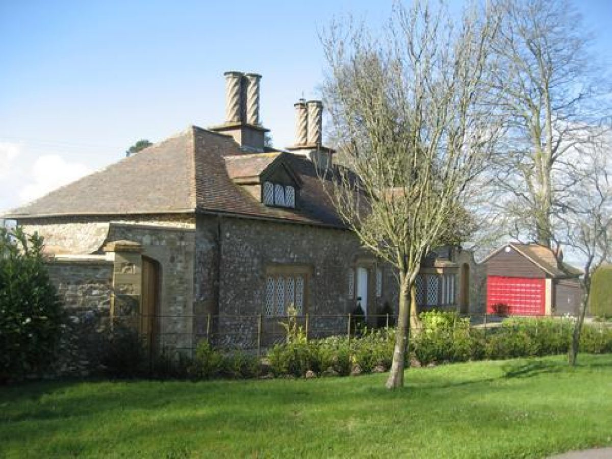
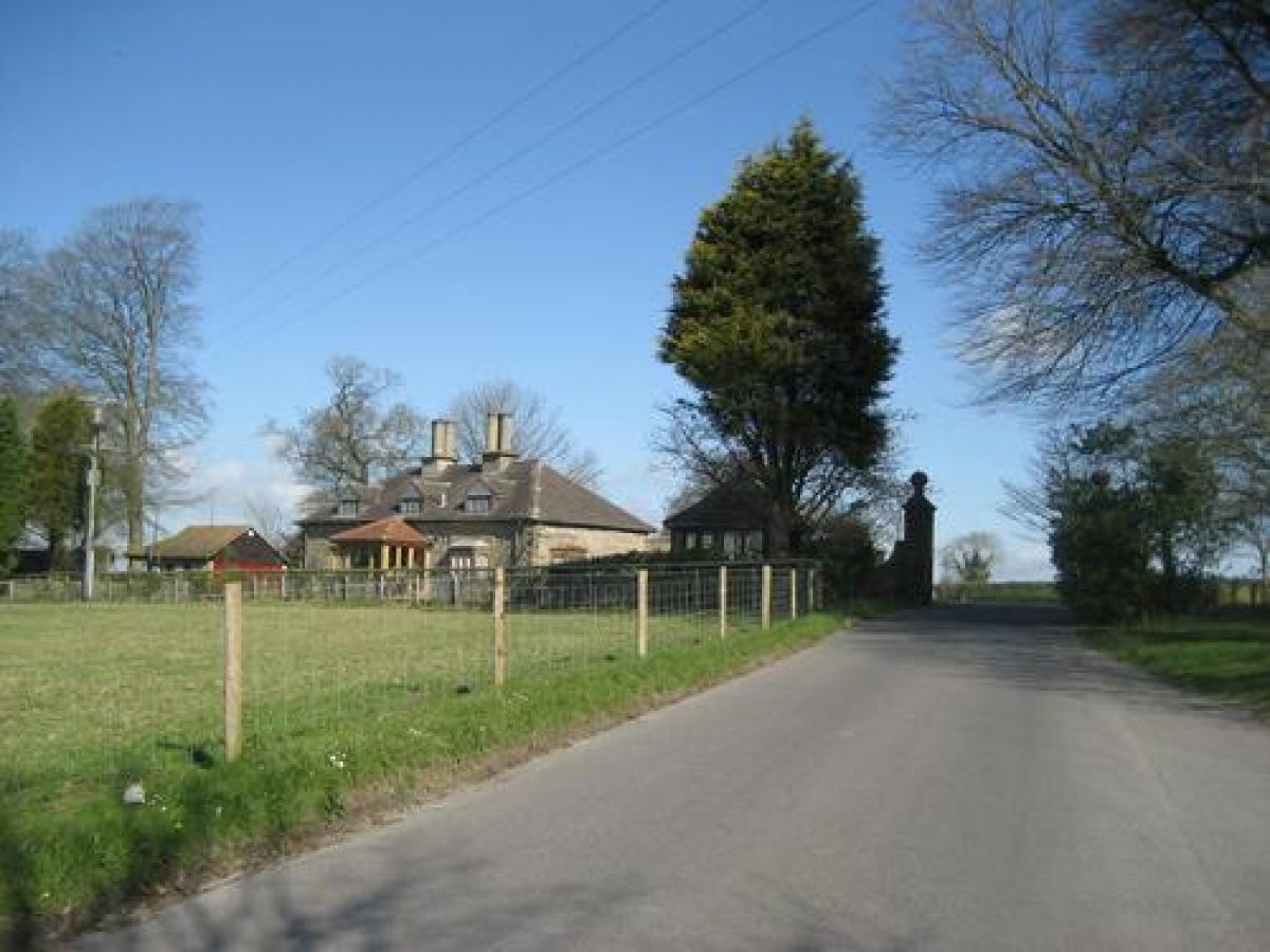
Today (2003) the principal entrance to Cricket House is from the A30 road to the north-west, at a point known as White Down. The entrance is set back from the road beyond a triangular-shaped area of grass and is marked by a single-storey stone lodge, Grosvenor Lodge (listed grade II), built in a Picturesque style in 1834. From the entrance a tarmac drive leads south, parallel to the western boundary of the site, dropping gently down the east-facing valley side and allowing extensive views towards the house and across the park. Sweeping south-east and east, the drive enters the pleasure grounds through a white-painted metal gate of early C19 design. The drive continues through an area of informal lawns and shrubberies to reach a gravel carriage turn beneath the north-west façade of the house. A C20 spur leads north from the north-west drive, parallel to the western boundary of the pleasure grounds, to allow access to an extensive area of mid and late C20 car parks c 160m north-east of the house. A drive leaves the north-east corner of the car park, and following a contoured course climbs gently along the south-facing valley side affording wide views across the site and the surrounding land to the south. The drive continues north-east, passing London Lodge Farm, to leave the site at its northern tip adjacent to a mid C19 single-storey lodge.
A further drive enters the site from the minor road forming its south-west boundary at a point c 400m west of Hollowells. This entrance is marked by Westport Lodge (listed grade II), a single-storey stone lodge, built in a Picturesque style in 1834 and altered in the late C19. A drive leads north-north-east from the entrance, passing through the park to the east of Manor Farm, and to the west of the Old Parsonage, joining the north-west drive at a point c 320m south-west of the house.
Principal Building
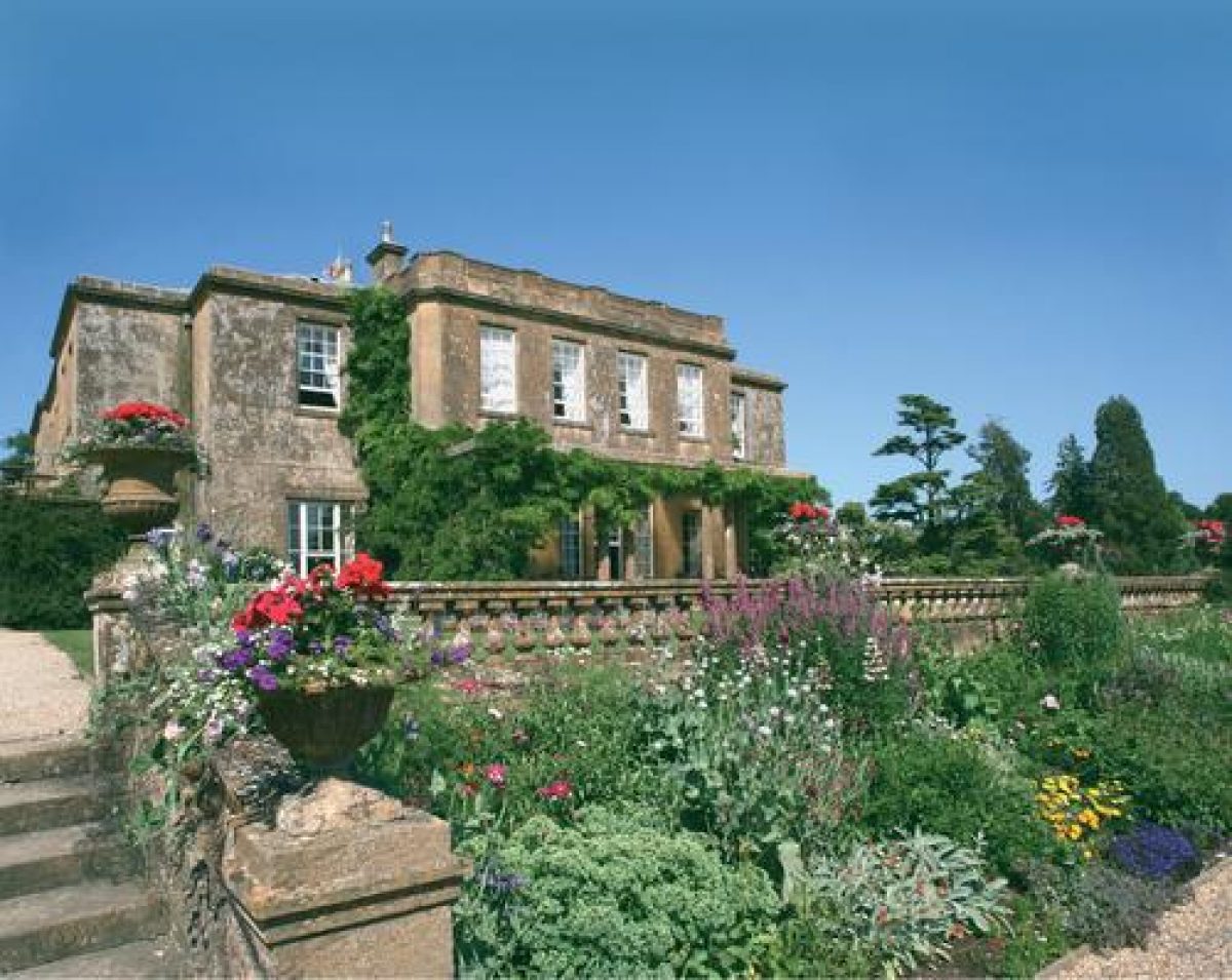
Cricket House (listed grade II) stands on an artificially levelled terrace overlooking the dammed stream, towards the centre of the site. Constructed in Ham stone ashlar under hipped slate roofs, the house comprises two storeys and an attic. The entrance or north-west façade has slightly projecting outer bays, and a centrally placed open portico supported by paired Tuscan columns. The south-west and south-east facades, both of which overlook the gardens, are of similar design, with a projecting central section and a single-storey colonnaded pergola.
The house assumed its present form between 1786 and 1807 when Admiral Hood, Lord Bridport commissioned Sir John Soane to build a new mansion or make extensive alterations to an existing house of C14 origin. The medieval manor house is popularly said to have stood within the area occupied by the late C18 kitchen garden and to have been destroyed by fire in the late C18 (VCH 1987); the present house appears however to relate to the formal terraces which are said to have been developed from the C17 gardens associated with the earlier manor house. Soane's house was altered in the late C19, when the entrance was moved from the south-west façade to its present position (Tithe map, 1831). Cricket House was converted into a hotel in the late C20.
Gardens and Pleasure Grounds
An area of informal lawns and shrubberies is situated to the north-west of the house, with trees and ornamental shrubbery to the east screening the early C19 stables and service quarters which have been incorporated into the C20 hotel. A narrow belt of shrubbery extends north-eastwards to St Thomas church (listed grade II*), which is approached from the C20 car parks by a path lined by a late C20 avenue of cypress trees. A walk leads south-west from the west corner of the churchyard to give access to further areas of shrubbery, through which a walk passes to the formal gardens around the house.
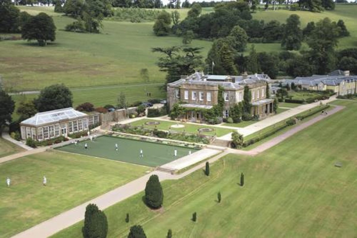
Formal terraced gardens are situated to the south-east and south-west of the house. A gravel terrace below the south-east façade returns beneath the south-west façade, and is edged by panels of lawn with a centrally placed circular pool flanked by circular flower beds to the south-west. The terrace is retained to the south-east by a low stone wall surmounted by regularly placed stone urns on pedestals; the wall may originally have supported a balustrade similar to that on the south-west terrace. The terrace to the south-west of the house is terminated to the west by a stone wall and bench seat. Stone steps descend from the south-west and south-east ends of this upper terrace, the south-east flight terminating the south-east terrace, to reach a second south-west terrace which is laid out as rectangular croquet lawn. The lawn is edged by gravel walks, while to the north-west it is overlooked by a single-storey Classical-style conservatory (listed grade II). The conservatory, although early C19 in style, is not shown on the 1831 Tithe map and may be contemporary with the formation of the terraces in the mid or late C19. The gravel walks to the east and west of the croquet lawn lead to further flights of stone steps which descend to a gravel walk which affords southerly views across the park. To the west, this walk is terminated by a single-storey classical loggia, the roof of which is accessible from the croquet lawn terrace to serve as a belvedere. To the east, the walk leads to a flight of stone steps which descends to a grass terrace extending north-east below the croquet lawn terrace. The grass terrace is planted with an avenue of mature Irish yews. This terrace, and that below the south-east façade of the house, overlook an east-facing sloping lawn which drops down to a gravel walk which leads south-west through the valley above the lakes.
The formal terraced gardens appear to have assumed their present form in the mid C19, and are shown in a watercolour of 1849 (VCH 1978), at which time the croquet lawn was laid out with geometrical flower beds; no designer has yet been identified as being responsible for this work. It is possible that the present terraces derive from the late C17 or early C18 garden terraces associated with the earlier manor house, but no clear evidence for these is shown on the Tithe map (1831). This map shows the house standing in an area of lawns and informal pleasure grounds, with a carriage turn on the site of the present south-west terrace.
Park
The park surrounds the house and pleasure grounds on all sides and comprises a valley extending from north-east to south, through which flows a small stream. The valley sides are undulating, with ornamental plantations articulating some of the projecting shoulders of high ground and framing extensive vistas from the upper slopes. The park is in mixed agricultural use, with the area adjacent to the house being principally laid to pasture. A chain of some seven lakes and pools separated by cascades is situated in the valley to the east and south of the house.
Some 670m north-east of the house, the Admiral's Seat (listed grade II) stands on high ground, backed to the north-east by a mixed plantation. The seat, a gabled stone structure incorporating C16 fragments, perhaps derived from the earlier Cricket House, is dated 1795; its design has been attributed to Soane, while its name commemorates Admiral Hood, Lord Bridport (d 1814). The former Parsonage, an C18 stone house, stands in the park c 240m south-west of the house adjacent to the site of the village of Cricket St Thomas, which was removed in the early C19 (VCH 1978). The early Manor Farm is situated c 670m south-west of the mansion.
The park assumed its present form in the late C18 and early C19, when Admiral Hood, Lord Bridport and his great nephew, Samuel, second Lord Bridport, enclosed the parish, demolished the houses in the village, and imparked the former agricultural land (ibid; Bond 1999) in order to improve the setting of the new mansion. The development of the park appears to have continued into the 1830s, as the chain of lakes is not shown on the Tithe map (1831). It is possible that the early C19 park incorporated a medieval park on the slope to the north-west of the house (VCH 1978).
Kitchen Garden
The kitchen garden is situated c 270m north-east of the house on the south-east-facing slope above the river. The garden is approximately rectangular on plan and is enclosed by stone walls. The interior of the garden was developed as part of the wildlife park created in the mid C20 and today (2003) it is subsumed within the hotel development.
The early C19 Home Farm is situated to the south-east of the former kitchen garden.
Maps
- Tithe map for Cricket St Thomas parish, c 1831 (M5128/1), (Somerset Record Office)
- OS 6" to 1 mile: 1st edition published 1885; 1931 edition
Illustrations
- Watercolour, Cricket House from the south-west, 1849 (reproduced in Victoria County History 1978)
Archival items
- Hippisley family archive, C18 (DD/HI), (Somerset Record Office)
- Hall family archive, 19th and early 20th century (DD/HA), (Somerset Record Office)
- Early 20th-century photographs of the grounds at Cricket House, published in Somersetshire Country Houses and Villages (1931)
Description written: December 2003
Amended (PAS): April 2004
Edited: July 2021
- Visitor Access, Directions & Contacts
Telephone
01460 30111Access contact details
Cricket House is now run as a Hotel and entertainment venue by Warner Leisure Hotels.
Directions
The hotel is off the B3167, which can be reached from the M5 (junction 25), via the A358 and A30.
- History
The following is from the Register of Parks and Gardens of Special Historic Interest. For the most up-to-date Register entry, please visit The National Heritage List for England (NHLE):
11th - 14th Century
In the 11th century, the manor of Cricket was held by a family of the same name, with whom the estate remained until 1328-9 when Michael of Cricket sold it to Walter de Rodney, who subsequently conveyed it to John of Clevedon (Victoria County History 1978).
15th - 18th Century
The manor passed through several ownerships before being sold in 1466 to Stephen Preston, whose great-grandson, John, was succeeded by his daughter Margaret (died 1672), who was married to John Hippisley of Ston Easton, Somerset (see description of this site elsewhere in the Register). Cricket continued in this family until 1775, when Richard Hippisley Coxe sold it to the naval commander, Admiral Alexander Hood (1726-1814), who was subsequently created Baron Bridport (1794) and Viscount Bridport (1800). Lord Bridport commissioned Sir John Soane (1753-1837) to remodel Cricket House in 1786, and further alterations were made by the same architect in 1801-07; it is unclear whether Soane altered an existing house which had its origins in the early 14th century, or whether his building was completely new (VCH 1978).
18th - 19th Century
The remains of the village of Cricket St Thomas were removed in the late 18th or early 19th century, and the majority of the parish was enclosed to form the park as a setting for the new mansion.
Lord Bridport was succeeded in 1814 by his great-nephew, Samuel, who in turn left it to his son, Alexander Nelson Hood, in 1868 (created Viscount Bridport, 1868 and by right of his mother, great-niece of Admiral Viscount Nelson, Duke of Bronte, Italy). By the late 19th century the estate was heavily mortgaged and in 1898 it was sold to the chocolate manufacturer Francis Fry (died 1918) (VCH 1978).
20th - 21st Century
The property passed through several hands in the early and mid 20th century, and a wildlife park was developed in the grounds from around 1967.
The house and immediate grounds were sold for conversion into a hotel in the late 20th century, and today (2021) the house is run as a hotel and entertainment venue by Warner Leisure Hotels.
Period
18th Century (1701 to 1800)
- Associated People
- Features & Designations
Designations
The National Heritage List for England: Register of Parks and Gardens
- Reference: GD2145
- Grade: II*
Features
- House (featured building)
- Earliest Date:
- Latest Date:
- Plantation
- Stream
- Description: A tributary of the River Axe.
- Lake
- Description: Chain of lakes
- Key Information
Type
Park
Purpose
Ornamental
Principal Building
Commercial
Period
18th Century (1701 to 1800)
Survival
Extant
Hectares
273
Open to the public
Yes
Civil Parish
Cricket St.
- References
References
- {English Heritage Register of Parks and Gardens of Special Historic Interest}, (Swindon: English Heritage, 2008) [on CD-ROM] Historic England Register of Parks and Gardens of Special Historic Interest
- Bond, J., {Somerset Parks and Gardens} (Tiverton: Somerset Books, 1998), pp. 119-22 Somerset Parks and Gardens
- Pevsner, N., {The Buildings of England: South and West Somerset} (Harmondsworth: Penguin, 1958), pp. 140-1 The Buildings of England: South and West Somerset
- {Victoria History of Somerset, Volume 4} ([n.p.]: Oxford University Press for the Institute of Historical Research, 1978), p. 133-6 Victoria County History: Somerset, Volume 4
- (1931), pp 91-5 Somersetshire Country Houses and Villages
- Related Documents
-
CLS 1/331
Historic Landscape Management Plan - Digital copy
LUC - 1993
-
CLS 1/331