Introduction
Farnborough Hall is set within a formal and terraced garden area of about 6.5 hectares, surrounded by an 18th-century landscape park. Features include an S-shaped terrace and serpentine walk.
Terrain
The site has a varied topography with hills rising to the north-west, south-east, and east of the Hall.
The following is from the Register of Parks and Gardens of Special Historic Interest. For the most up-to-date Register entry, please visit the The National Heritage List for England (NHLE):
www.historicengland.org.uk/listing/the-list
An extensive mid-18th-century landscape with significant elements designed by Sanderson Miller, together with early 19th-century gardens and pleasure grounds.
DESCRIPTION
LOCATION, AREA, BOUNDARIES, LANDFORM, SETTING
Farnborough Hall is situated c 9km north of Banbury and c 2km north-west of the village of Mollington, to the west of the A423 Oxford road. The c 115ha site comprises some 5ha of gardens and pleasure grounds around the Hall, and a further c 110ha of parkland, lakes, and ornamental plantations. The site is bounded to the north-east by a minor road leading from the village of Farnborough to Burton Dassett, and by the village of Farnborough. The east boundary adjoins agricultural land immediately to the west of the A423 road, while to the south and west the site adjoins agricultural land. The south-east boundary of the site follows the boundary between Warwickshire and Oxfordshire. An avenue extends south-west from the site through agricultural land, while a minor road leading west from Farnborough to Avon Dassett passes through the site to the north-west of the Hall; this road was constructed on its present course by Archdeacon Holbech in the mid C19 (guidebook). The site has a varied topography with hills rising to the north-west, south-east, and east of the Hall. A stream flows from north to south through the site c 200m west of the Hall; this has been dammed to form three lakes (one dry, 2000). A further stream flows from east to west c 80m north of the Hall; this has been dammed to form two rectangular pools. There are significant views west and south from the Terrace Walk across the Vale of the Red Horse and the Warmington valley which are framed to the south-west by the Edge Hill escarpment and to the north-west by the Dassett hills; there is late C18 or early C19 ornamental planting on the south-facing slope north of the minor road leading from Farnborough to Avon Dassett immediately west of the site. Further views extend north and north-east from the park towards Northamptonshire, the boundary of which county lies c 3km north-east of the site.
ENTRANCES AND APPROACHES
Farnborough Hall is approached from the village of Farnborough to the north-east. The entrance is marked by a pair of low stone piers surmounted by ball finials (listed grade II) which support a single early C19 timber and metal gate. The entrance is flanked to north-west and south-east by low saddle-coped stone walls (listed grade II). A gravelled drive flanked by rectangular lawns extends c 80m south-west through the outer forecourt. The outer forecourt is enclosed to the north-east by evergreen shrubbery and mature trees which screen the public road, while to the north-west it is enclosed by stone walls (listed grade II). To the south-east, Lady Pond, a rectangular pond of C17 or earlier origins adjoins the outer forecourt, from which it is separated by a simple railed clairvoie; a mature Liriodendron grows within the forecourt adjacent to the pond.
At the south-west end of the outer forecourt, the drive crosses a service drive which leads south-east to the park, and north-west to the early or mid C18 stables (listed grade II) and the early C19 coach house (listed grade II) which enclose a cobbled yard c 50m north of the Hall. The stables were remodelled and the coach house built by Henry Hakewill for William Holbech IV in 1815-16. A further gravelled drive leads c 50m north-west from the stable yard to the Avon Dassett road. This road was diverted to its present course by William Holbech IV in 1815 (WCRO); in 1772 it passed through the farmyard c 50m north of the Hall and thence along the boundary of the pleasure grounds, c 30m south-east of its present route.
The principal drive passes from the outer forecourt into the inner forecourt below the north-east facade of the Hall through a pair of low, ornamental wrought-iron gates. These are supported on a pair of low stone piers with flat tops which are in turn flanked by low stone walls with flat coping and regularly spaced piers supporting urns (walls listed grade II); the gates, piers, and flanking walls were designed by Hakewill c 1815 (guidebook). The inner forecourt is enclosed to the north-west by a high brick wall which curves down to the north-east wall in two stages; a similar wall encloses the forecourt to the south-east. Doors set in the walls near the Hall lead respectively north-west to the pleasure grounds and south-east to the former service quarters. The drive encloses a central circular lawn, while further panels of lawn to the north-west and south-east separate the carriage turn from herbaceous borders.
PRINCIPAL BUILDING
Farnborough Hall (listed grade I) is situated towards the centre of the site below a north-west- and west-facing slope which rises rapidly to the south-west, and above an area of park which drops away to the lakes to the south-west. The Hall is constructed in local Hornton stone with Warwick stone dressings including window-surrounds, door-cases and parapets. 'U' shaped on plan, the entrance is on the north facade, deeply recessed between projecting wings with rusticated quoins and a pair of round-headed niches on the inner face of the projecting pavilions. The north facade is probably a re-casing of C16 or C17 work undertaken by William Holbech II with the advice of Sanderson Miller c 1749. The west facade comprises seven bays, with a Warwick stone centrepiece rising from a monumental garden door to an attic dormer. This facade was constructed c 1700 for William Holbech I, and has been attributed to William and Francis Smith (guidebook). The south or garden facade is seven bays wide with a shallow projecting central section comprising five bays, and was achieved by in-filling a courtyard on the south side of the C17 house. A Palladian door is set at the centre of the facade, while the first-floor windows are square rather than rectangular. The design of the south facade has been attributed to Sanderson Miller, and formed part of the improvements undertaken by William Holbech II c 1749. An extensive service wing was added to the east side of the Hall by Henry Hakewill in the early C19; this was removed in the mid C20.
The interior of the Hall retains significant mid C18 interiors completed for William Holbech II by leading craftsmen, with important plasterwork by William Perritt.
GARDENS AND PLEASURE GROUNDS
Informal and formal gardens and pleasure grounds lie to the west of the Hall, with further informal pleasure grounds and walks to the south; there is a further detached area of pleasure grounds and walks to the north.
To the west of the Hall a level lawn extends c 50m north-west to an C18 brick ha-ha which allows views to Sourland Pool and Stambra Wood c 160m north-west of the Hall; a narrow flight of brick steps descends from the lawn to a wicket gate leading to the park beyond. The lawn is planted with a mature specimen cedar and a group of rhododendrons; to the north it is enclosed by evergreen shrubbery and trees which serve to screen the early C19 stables. A gravel walk extends along the north and west sides of the lawn to reach a walk which leads south-west from the lawn. This gently sloping gravel walk is separated from parkland south of the Hall by a holly hedge, and is sheltered to the west by mixed ornamental shrubbery and specimen trees. Some 100m west of the Hall the walk reaches a shallow flight of stone steps which ascends to a partly stone-flagged terrace with inset borders planted with lavender and roses. The terrace is enclosed to the west and north by brick walls c 3.5m high, and to the south by a low stone balustrade; a stuccoed niche in the centre of the west wall contains a wooden bench seat. The terrace and walls are the remains of a conservatory constructed in 1776 (guidebook 1963) for William Holbech III. An early C19 brick-lined icehouse (listed grade II) is situated under a mound planted with evergreen shrubs immediately north-west of the site of the conservatory. A flight of stone steps descends south from the terrace to a formal rose garden which is enclosed to the east and south by stone balustrades, and to the west by a higher stone wall. The garden comprises geometric box-edged beds separated by gravel walks which have as their focal point a circular box-edged bed which is divided into quarters by further box hedges. A C19 stone urn stands on a stone pedestal at the centre of the garden, and there are further C20 stone urns arranged on the surrounding balustrades. The rose garden formed part of the early C19 improvements to the pleasure grounds made by Henry Hakewill. To the east of the rose garden the gravel walk continues c 50m south-west to reach a mid C18 cascade (restored late C20) at the head of Rookery Pool. The cascade comprises a high, rustic stone retaining wall with a central waterfall which descends to a stepped base. A level platform on the north side of the cascade is the site of a summerhouse, the foundations of which have been exposed through archaeological investigation. The cascade formed part of William Holbech II's mid C18 development of the pleasure grounds and may have been designed by Miller; it was constructed on the site of an earlier mill (Garden Hist 1997). The pleasure ground walk corresponds to an early C18 yew walk which ran parallel to the west boundary of the gardens. The boundary was moved c 10m north-west in the mid C18 or early C19, when a belt of pines and evergreen shrubbery was planted. A late C20 grass walk bordered by ornamental shrubs has been formed leading north-east past the icehouse to regain the west lawn.
The west lawn returns below the south facade of the Hall, where an early or mid C18 stone baluster sundial (listed grade II) stands c 5m west of the south-west corner of the Hall. The south lawn is separated from the park by box hedges, and rises sharply to the south-east to join the Terrace Walk. The Terrace extends c 700m south and south-east, ascending gently to reach a mid C18 obelisk (listed grade II) which overlooks the Hanwell valley. The Terrace is laid to grass and has twenty-six bastions planted in C20 with specimen limes projecting from its western side; the limes replace the C18 planting of elms. The views west across the Vale of the Red Horse are partly obscured by a tall C20 laurel hedge which separates the Terrace from the park below. To the east, the Terrace is backed by a belt of specimen trees, evergreen shrubbery, and groups of mature beech, through which a serpentine walk extends, providing an alternative return route with glimpsed views east across the park. Beyond the obelisk, the Terrace turns sharply east, revealing further views towards Shotteswell and Banbury, and extends c 350m east and north-east to reach the site of the Pentagon Temple, a mid C18 structure which stood at the highest point of the grounds immediately west of the mid C19 Park Cottage. The Pentagon Temple was described in 1746 as an 'elegant and costly building' (Hypomnemata), while in 1747 Lady Newdigate of Arbury Hall, Warwickshire (qv), commented that it comprised a lower room 'in ye form of a Pentagon without and a Rotunda within' supported on five arches, above which was a further room with a balustrade commanding 'a pretty good prospect'(WCRO). The Temple is marked on Yates' Map of Warwickshire (1793), but had been removed by the mid C19 (OS 1834); no trace of the structure remains above ground (2000). The final section of the Terrace is marked by regularly spaced bastions on the inner side, and semi-mature specimen oaks.
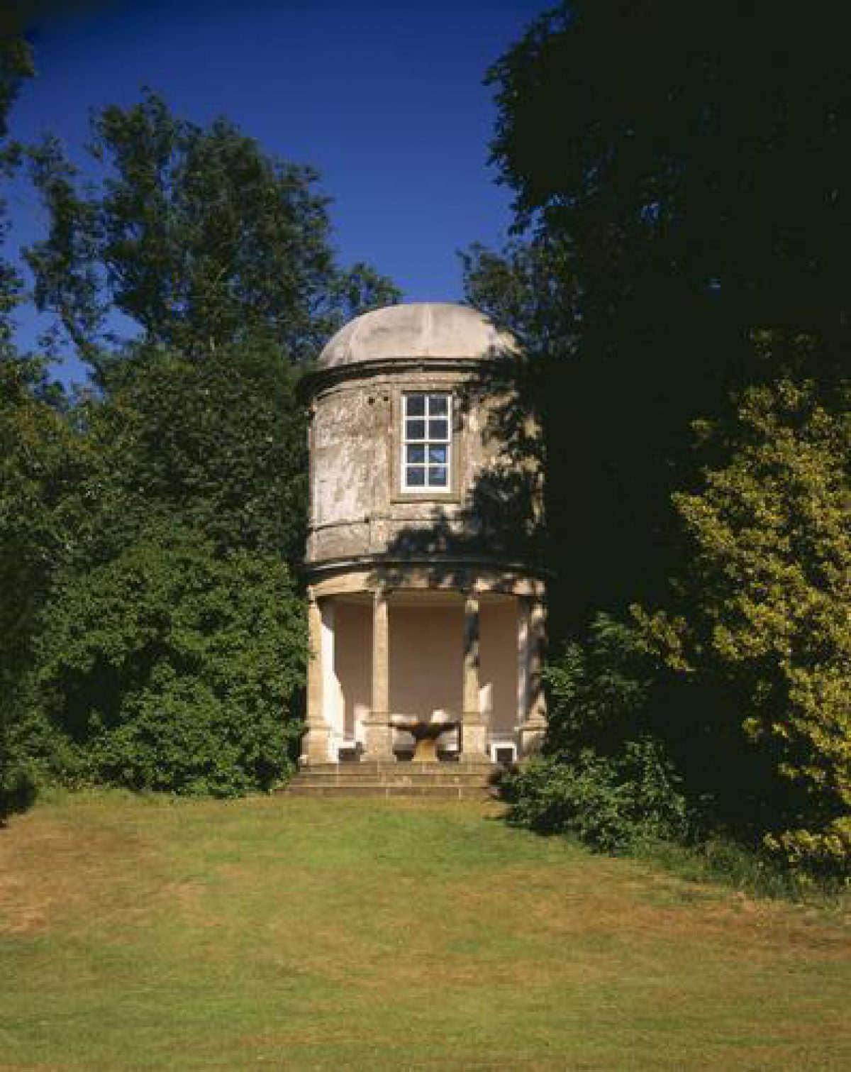
The lower section of the Terrace is ornamented with three structures. Some 320m south of the Hall the Ionic Temple (listed grade II*) stands on a semicircular bastion projecting from the west side of the Terrace surrounded by C19 ornamental shrubbery which today (2000) partly obscures a reciprocal view to the Hall. The Temple comprises an open pediment supported by four Ionic columns fronting a rectangular stone-flagged recess which contains a timber bench seat. The Ionic Temple was constructed c 1750, probably to the design of Sanderson Miller. Some 590m south of the Hall, the Oval Pavilion (listed grade II*) stands on a mound on the east side of the Terrace, marking a change in its direction from south-west to south-east. Oval on plan, the pavilion comprises a ground-floor loggia supported by four Tuscan columns, within which a stone-flagged recess supports an elliptical stone table and a bench seat. A curved flight of stone steps with a wrought-iron hand-rail ascends outside the east facade of the pavilion to reach a first-floor prospect room which is decorated with fine ornamental plasterwork attributed to William Perritt. There are extensive westerly views from this room. The Oval Pavilion was constructed c 1750, probably to the design of Sanderson Miller, inspired by the oval pavilion attributed to Inigo Jones in the grounds of Ecton Hall, Northamptonshire (Garden Hist 1997). The third structure is the mid C18 obelisk which marks the southern end of the principal or lower terrace. The design of the obelisk is also attributed to Miller; it is first noted in a visitor's description of 1746 (Hypomnemata). Some 130m south-east of the Hall a mid C18 Game Larder (listed grade II*) stands to the north-east of the Terrace Walk; it is separated from the Terrace by a mid C18 brick wall c 3m high, and is approached through a door set in the wall. The Game Larder stands on a semicircular grassy bastion enclosed by a holly hedge; a C19 wrought-iron gate leads south-east to the adjoining paddock. The Game Larder comprises an octagonal pavilion surmounted by a pitched roof and a louvered timber cupola. The northern sides of the pavilion are recessed, the roof being supported on Tuscan columns to shelter a bench seat set on a flagged terrace. There are reciprocal views north-east across the paddock, Lady Pond, and Island Pond and orchard towards St Botolph's church and the kitchen garden. The Terrace was in existence by 1742 when John Loveday recorded riding on it (Markham 1984; Garden Hist 1997); its design is attributed to Miller (Miller 1900).
There are two further, detached areas of pleasure grounds to the north-west and north of the Hall. Some 160m north-west of the Hall and separated from the gardens by the road to Avon Dassett and a meadow known in the late C18 as Miller's Close (1772 survey), Sourland Pool is a mid C18 lake of natural appearance which is retained to the south and west by a massive earth dam. A walk planted with mid C18 specimen trees follows the edge of the lake along the top of the dam, affording views south-west across a meadow which is enclosed to the west by a belt of pines and ornamental plantation. An outflow from the lake c 500m north-west of the Hall forms a waterfall feeding a stream which flows through the western boundary plantation. A narrow arm of lake extends north for c 130m north of the waterfall, giving views west to Dassett Field Farm. There are further walks on the north side of Sourland Pool which pass through Stambra Wood, a mixed mid C18 and early C19 plantation. Within the trees large banks and ditches survive which relate to the enclosure of a crescent-shaped plantation and a semicircular plantation shown on Stanborough Hill in 1772 (survey). These plantations were extended in the early C19 and are shown in their present form on the late C19 OS map (1886). Immediately to the south-west of Sourland Pool, and separated from it by the south dam of that lake, the Oval Pool is today (2000) an approximately elliptical-shaped wooded depression enclosed to the south and north-west by further massive earth banks which originated in the mid C18 as dams retaining a further lake. A walk lined with mature deciduous trees follows the top of the dam south-west and north-east to join the walk along the top of the west dam of Sourland Pool. The views south-east towards the park and Terrace Walk from the Oval Pool dam are today partly obscured by scrub, but there are further views south-west and south from a bastion-like area at the south-west corner of the former Pool.
A further area of detached pleasure ground survives as earthworks in fields c 750m north of the Hall. An elongated mound extends c 270m north-east from a mound adjacent to the Burton Dassett road to a further mound planted with a clump of yew trees; this corresponds to the 'Gardeners Hill Shrubbery' shown on the 1772 estate survey. An ornamental clump of trees is planted on the summit of Windmill Hill c 800m north-north-east of the Hall, while a curving terrace extends c 700m from the minor road leading north from Farnborough village to a point c 80m north-west of the northern end of Gardeners Hill Shrubbery. The western section of this terrace corresponds to an approximately semicircular avenue shown on the 1772 plan; tree stumps survive adjacent to it today (2000). There are significant views in all directions from the summit of Windmill Hill, while the early C18 Dassett Field Farm (listed grade II*) c 880m north-west of the Hall acts as an eyecatcher. From the northern terrace there are views across north Warwickshire, and, closer to, of meadows and woodland on Halls Hill. There are also significant views to the mid C18 terrace south-east of the Hall from Gardeners Hill Shrubbery. Windmill Hill and Gardeners Hill Shrubbery are visible from the park and the site of the Pentagon Temple on high ground c 720m south-east of the Hall, and formed a northern circuit of features and walks complementing the southern Terrace Walk and pleasure grounds.
PARK
The park comprises two areas: land to the south of the Hall on the west- and south-facing slopes below the Terrace Walk; and on the high ground to the south-east of the Hall, and east of the Terrace Walk. The park to the south of the Hall comprises pasture with mixed scattered trees on the slope which drops from the Terrace Walk to Rookery Pool, a long, narrow, approximately L-shaped lake which is fed via the cascade by the outflow from Sourland Pool and the Oval Pool. To the west of Rookery Pool a stream is dammed to form a series of serpentine pools separated by the remains of C18 dams and sluices; these are separated from Rookery Pool by an area of woodland. Rookery Pool was adapted in the early C19 from the mid C18 'River' and the 'Canal' (1772 survey). The canal to the south-west was aligned on the south facade of the Hall; a ha-ha at its south-west end separated the park from a formal avenue which extended c 1.2km through farmland. This avenue of oaks (replanted late C19) survives today (2000), extending through the site of the mid C20 College Farm. The serpentine pools west of Rookery Pool, with a shrubbery walk between them and the Pool, is similar to features designed by Miller at Wroxton Abbey, Oxfordshire (qv), and Honington Hall, Warwickshire (qv). The shrubbery walk was reached from the park by a bridge which is shown on the 1772 survey; this does not survive.
A track leads south-west and south from the western (lower) end of the Terrace Walk through the south park, passing to the north of an early C19 picturesque dairy c 320m south-south-west of the Hall. The design of the dairy is attributed to Hakewill; it formed part of the remodelling of the south park and Rookery Pool which was undertaken for William Holbech IV c 1815. In the late C18 the south park was divided into three enclosures. The north-east enclosure was known as the Dairy Ground, while that to the south-west was the Warren. The third enclosure, a low-lying meadow below the obelisk, was known as Markham Hole; by the late C19 it was separated from the Warren by a sunk fence (OS 1886). Trees shown planted in a single line around the north and west boundaries of the Warren and Markham Hole (1722) remained in the late C19, but do not survive today (2000).
The south-east park comprises an extensive single pasture enclosure with scattered trees on a north-east-facing slope, and the summit of Markham Hill south-east of the Hall. There are extensive views north to Gardeners Hill Shrubbery and Windmill Hill, and east to ornamental planting on Oak Hill. To the north the park is separated from the paddock by an C18 brick wall c 3m high, while to the west it is bounded by a C20 fence which separates it from the Terrace Walk. The eastern or upper terrace now (2000) lies within the park. On the summit of Markham Hill, some 530m south-east of the Hall, a late C19 or early C20 single-storey timber and corrugated-iron cricket pavilion survives in a derelict condition. In the late C18 the south-east park comprised three enclosures, of which the northern enclosure was described as the 'Park'. Some of the trees within the present park correspond to the C18 enclosure boundaries; these boundaries were removed in the early C19.
KITCHEN GARDEN
The kitchen garden is situated c 400m east-north-east of the Hall, to the north-east of a minor road which leads south-east from Farnborough village along the east side of the park. The garden is octagonal on plan, and is enclosed by late C18 brick walls c 3m high (listed grade II) under stone coping. Doorways are placed centrally in the west, south, and east walls. Attached to the outer side of the north wall of the garden a late C18 two-storey brick cottage (listed grade II) stands in a former service yard. The garden is today (2000) laid to grass, with the northern section forming a late C20 garden associated with the cottage. Slip gardens survive in an overgrown condition to the west, south, and east of the kitchen garden; dividing walls extending from the south-west and south-east corners of the kitchen garden walls survive, and the slips are enclosed from the adjacent meadow by timber and metal fences. The kitchen garden appears to have been constructed in the late C18 for William Holbech III; it is not marked on the 1772 survey.
The kitchen garden is linked to the grounds around the Hall by a track, which today serves as a drive for the cottage. This extends c 130m south-west across the meadow, crosses the minor road and enters the grounds north-east of the Hall through a timber doorway set in a stone boundary wall. The south-west-facing slope above the rectangular C17 Lady Pond and Island Pond is today laid to grass with scattered mature standard fruit trees; these survive from an orchard which is shown on the 1772 survey and the late C19 and early C20 OS maps (1886, 1906, 1938).
OTHER LAND
Oak or Oakal Hill, a meadow c 530m south-east of the Hall and to the east of the minor road which forms the eastern boundary of the park, forms a knoll of high ground, the summit of which is planted with an ornamental group of trees. Within the field, and parallel to its boundaries, is planted a single row of oaks. Some of these trees are mature, while others are C20 replacements. A belt of ornamental planting including a picturesque group of pines extends along the western boundary of Oak Hill, and, together with the planting on the summit of the Hill, forms a significant feature in easterly views from the south-east park. The boundary and summit planting on Oak Hill is shown on the 1772 survey, and reflects a pattern of planting elsewhere on the site, including the Warren, Markham Hole, the south-east park, and Baker's Hill and Beers Hill which formed part of the detached pleasure ground north of the Hall. A similar method of planting is shown on the late C18 survey of neighbouring Upton House, Warwickshire (qv), where an extensive network of mid C18 rides and walks was created, probably with the advice of Sanderson Miller, through parkland and agricultural land.
REFERENCES
R Jago, Edge Hill (1767), p 129
G Miller, Rambles Round the Edge Hills (1900), p 59
J J Cartwright (editor), The Travels through England of Dr Richard Pococke II, (1888-9), p 260
Victoria History of the County of Warwickshire V, (1949), pp 84-8
Country Life, 115 (11 February 1954), pp 354-7; (18 February 1954), pp 430-3; no 28 (11 July 1996), pp 52-5; no 29 (18 July 1996), pp 50-3
Farnborough Hall, guidebook, (National Trust 1963)
N Pevsner and A Wedgewood, The Buildings of England: Warwickshire (1966), pp 292-3
Farnborough Hall, guidebook, (National Trust 1981)
S Markham, John Loveday of Caversham 1711-1789: the Life and Tours of an Eighteenth Century Onlooker (1984), p 342
Farnborough Hall, Warwickshire, Historic Landscape Survey and Restoration Plan, (Land Use Consultants 1993)
G Tyack, Warwickshire Country Houses (1994), pp 88-91
Garden History 25, no 1 (1997), pp 81-106
Farnborough Hall, guidebook, (National Trust 1999)
Maps
E Linnell, Survey of Farnborough, 1772 (Z403u), (Warwickshire County Record Office) [reconstruction of survey brought to a common scale by J Meir published in Garden Hist 1997, p 99]
W Yates and Son, Map of Warwickshire, surveyed 1787-9, published 1793
Plan of proposed diversion of the road from Farnborough to Avon Dassett on the western boundary of the gardens, 1814-15 (QS47 roll 2 m.26a(c), (Warwickshire County Record Office)
OS Old Series 1" to 1 mile, published 1834
OS 6" to 1 mile: 1st edition published 1886; 2nd edition published 1906; 3rd edition published 1938
OS 25" to 1 mile: 1st edition published 1886; 2nd edition published 1900; 3rd edition published 1922
Illustrations
M Holbech, watercolour views of Farnborough, early 19th century (private collection)
Photographs, Farnborough Hall and grounds, late 19th/early 20th century (private collection)
Archival items
Hypomnemata [anonymous account of a visit to Farnborough, 1746], (British Library Add MS 6230)
Lady Sophia Newdigate's travel journal including a description of Farnborough, 1747 (CR1847/7), (Warwickshire County Record Office)
Sanderson Miller's diaries, 1746-50 (1382/1), (Warwickshire County Record Office)
Personal communication from Jennifer Meir
Description written: June 2000
Amended: September 2000; May 2001; October 2002
Edited: May 2001
- Visitor Access, Directions & Contacts
Telephone
1295670266Access contact details
Open April to September, Wednesday and Saturday, 2pm to 5.30pm.
Directions
6 miles north of Banbury, west of the A423
- History
The following is from the Register of Parks and Gardens of Special Historic Interest. For the most up-to-date Register entry, please visit the The National Heritage List for England (NHLE):
www.historicengland.org.uk/listing/the-list
HISTORIC DEVELOPMENT
The manor of Farnborough was held from 1322 to 1684 by the Raleigh family, who suffered significant financial losses through their support for the Crown in the Civil War. Following the death of George Raleigh in 1683, the manor was sold to Ambrose Holbech, whose father, a wealthy lawyer, had acquired property in the neighbouring village of Mollington. Ambrose Holbech continued to live at Mollington until his death in 1701, but in the late 17th century his son, William, settled at Farnborough following his marriage. William Holbech made alterations to an existing late 16th- or early 17th-century manor house, building a new west wing in about 1700. Holbech died in 1717 and was succeeded by his son, also William Holbech, who spent much of his time between 1730 and 1745 in Italy. On his return, Holbech, advised by his neighbour, Sanderson Miller (1716-80) of Radway Grange (see description of this site elsewhere in the Register), remodelled the house; leading craftsmen were employed on the interiors (Tyack 1994). Holbech also remodelled the park and pleasure grounds with the advice of Miller (Miller 1900; Garden Hist 1997; guidebook 1999); this work began before the remodelling of the house, the Terrace Walk being described by John Loveday in 1742 (Markham 1984). The design of a significant group of mid-18th-century landscape structures is attributed to Miller (Garden Hist 1997), Farnborough Hall being one of a group of sites in Warwickshire at which Miller advised on the development of the landscape. These include Alscot Park, Arbury Hall, Honington Hall, Packington Hall, and Upton House (there are descriptions of all these sites elsewhere in the Register). Richard Jago described the completed pleasure grounds 'Deck'd with no sparing cost of planted tufts, Or ornamental building' and the construction of the terrace by 'jocund labourers' in his poem Edge Hill (1767), and the layout is recorded on a survey of 1772 by Edward Linnell (Warwickshire County Records Office).
William Holbech died unmarried in 1771 and was succeeded by his nephew, also William, who served as MP for Banbury (1792) and Deputy Lieutenant (1796). His son, William Holbech IV, called in the architect Henry Hakewill to make alterations to the Hall, outbuildings, and pleasure grounds around 1815 (Tyack 1994). In 1856 William Holbech's third son, the Rev Charles Holbech, Archdeacon of Coventry, inherited the estate. Archdeacon Holbech made improvements to the village and church, but few changes to the Hall or grounds. The Archdeacon's son predeceased him, and in 1901 the estate passed to his grandson, William, whose uncle, Canon Hugh Holbech administered the property in his minority. William Holbech died of wounds sustained in October 1914, and was succeeded by his brother, Ronald. Ronald Holbech's eldest son, Edward Ambrose, who served in the RAF during the Second World War, was killed in an accident on VJ Day 1945. A settlement had been made on his only child, Anne Holbech, and her uncle, Geoffrey Holbech; in 1960 the Hall and 344 acres (about 143 hectares) of surrounding land was acquired by the Treasury, which subsequently transferred it to the National Trust (guidebook). The site remains (2000) in divided ownership.
- Associated People
- Features & Designations
Designations
The National Heritage List for England: Register of Parks and Gardens
- Reference: GD1003
- Grade: I
Features
- Obelisk
- Temple
- Pavilion
- Lawn
- Border
- Parterre
- Cascade
- Pool
- Fishpond
- Description: Stew pond.
- Garden Terrace
- Serpentine Walk
- House (featured building)
- Description: A late-16th or early-16th century manor house was altered in the late-17th century. Further changes were made after 1745 and around 1815.
- Earliest Date:
- Latest Date:
- Lake
- Stream
- Key Information
Type
Park
Purpose
Ornamental
Principal Building
Domestic / Residential
Survival
Extant
Hectares
115
Open to the public
Yes
Civil Parish
Farnborough
- References
References
- {English Heritage Register of Parks and Gardens of Special Historic Interest}, (Swindon: English Heritage, 2008) [on CD-ROM] Historic England Register of Parks and Gardens of Special Historic Interest
- Pevsner, N. and A. Wedgwood, {The Buildings of England: Warwickshire} (Harmondsworth: Penguin Books, 1966), pp. 292-3 The Buildings of England: Warwickshire
- Tyack, G., {Warwickshire Country Houses} (Chichester: Phillimore, 1994), pp. 88-91 Warwickshire Country Houses
- {Victoria History of the County of Warwickshire Volume 5} ([n.p.]: [n.pub], 1959), pp. 84-8 Victoria County History: Warwick, Volume 5
- Land Use Consultants {Farnborough Hall: Historic Landscape Survey} (1993) Farnborough Hall: Historic Landscape Survey
- Askew Nelson {Farnborough Hall Parkland Plan} (2013) Farnborough Hall Parkland Plan
- Related Documents
-
CLS 1/572
Parkland Plan - Digital copy
Askew Nelson Ltd. - 2013
-
CLS 1/573
Parkland Plan: Volume 2, Maps and Plans - Digital copy
Askew Nelson Ltd. - 2014
-
CLS 1/333
Historic Landscape Survey and Restoration Plan - Digital copy
LUC - 1993
-
CLS 1/503
Historic Landscape Survey and Restoration Plan - Hard copy
Land Use Consultants - 1993
-
CLS 1/520
Parkland Plan - Digital copy
Askew Nelson Ltd - 2013
- CLS 1/448
-
CLS 1/572