Introduction
Only 47 hectares now remain from a late-18th-century landscape park, designed by Lancelot Brown in 1776, which originally covered a larger area. The site is now a golf course, but retains the lake and woodland areas.
www.historicengland.org.uk/listing/the-list
A landscape park improved following submission of a scheme by Lancelot Brown in 1776 associated with a country house.
DESCRIPTION
LOCATION, AREA, BOUNDARIES, LANDFORM, SETTING
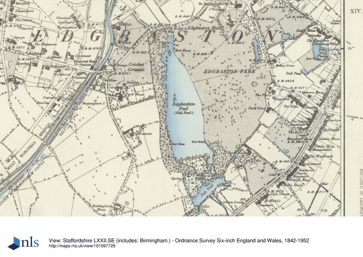
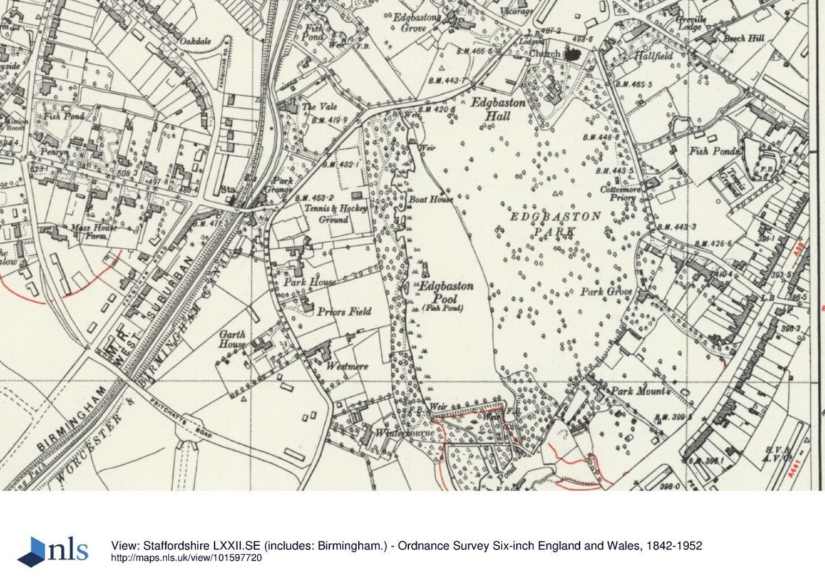
Edgbaston Hall stands c 4km south of the centre of Birmingham. To the south the park is bordered by the A38 Birmingham to Bromsgrove road and to the north and west by Edgbaston Park Road or houses along it. To the east it is bounded by Priory Road (the B4217), part of the old road from Birmingham to Worcester (turnpiked 1726) before the route was altered in the early 1770s to run along the line of the modern Bristol Road. Sir Harry's Road was then cut to provide access from the turnpike road to Edgbaston Hall and church. Beyond the south-west section of the park is the University of Birmingham. The registered area is c 47ha.
ENTRANCES AND APPROACHES
The Hall is approached from the north, via what was originally the back entrance on Edgbaston Park Road to the west of the church, where there is a two-storey brick lodge of C18 and C19 date. From here a short drive leads to car parks behind (north of) the Hall.
In the late C18 and earlier C19 the main approach was via a short drive from the north-east, on the east side of the churchyard.
PRINCIPAL BUILDING
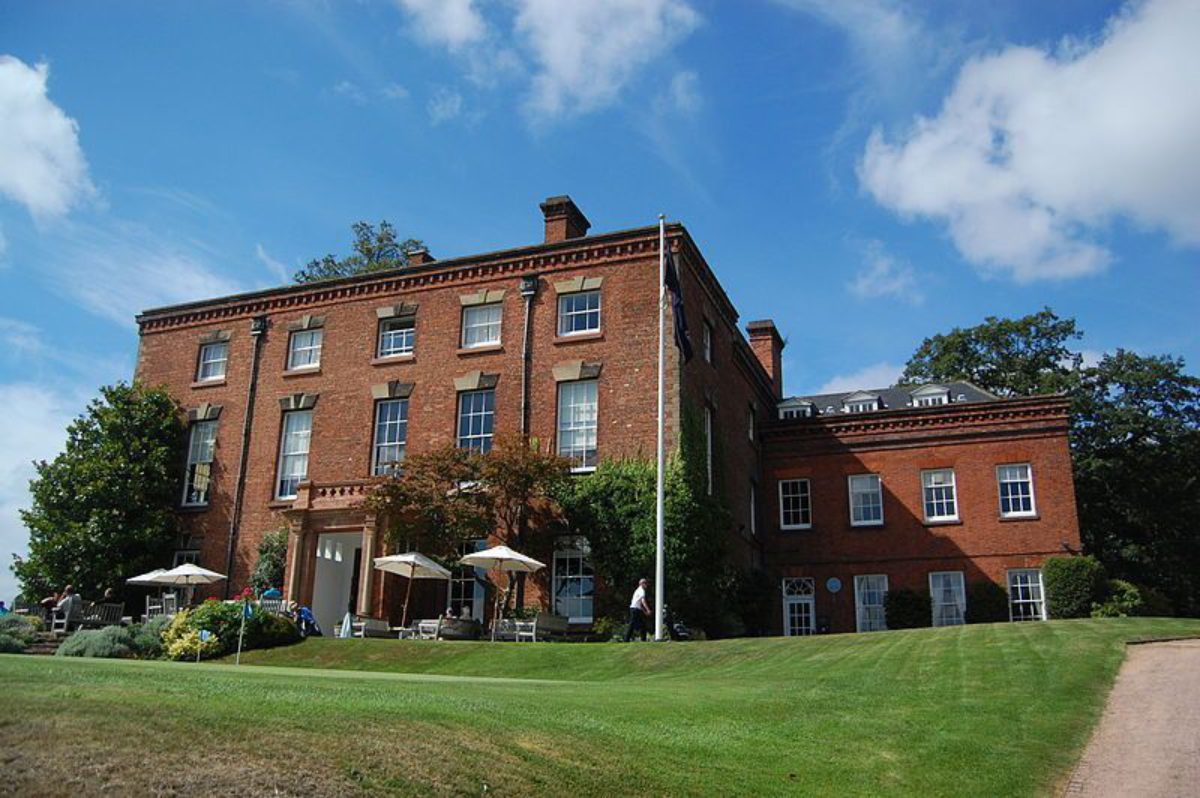
Edgbaston Hall (listed grade II) stands on a slight rise on an already elevated position with panoramic views to the south. The building is of brick with stone detailing, the main south-east front being of two-and-a-half storeys and five bays and with a central door with Tuscan columned porch. This is of 1717, when Sir Richard Gough rebuilt an earlier structure destroyed in 1688. Behind are various additions of later date, including a mid C18 north-east wing (possibly the work accounted for in the 1750s by William and David Hiorne) and some work of 1852 by Sir Charles Barry. Alterations to the Hall for the golf club have been mainly internal.
C18 and C19 stables stand north of the Hall. A brick, flat-roofed building west of the Hall, now used as a trolley store, was built c 1940 as a wireless station.
GARDENS AND PLEASURE GROUNDS
North of the Hall are car parking areas, screened by evergreen shrubberies. Along the south-east front is a paved terrace, giving access directly to the golf course. About 50m west of the terrace, and running along the west side of the Hall, is a brick-walled sunk fence. South and east of the Hall it has been removed.
About 1730 the Hall and its surrounds were depicted by Beighton (reproduced in Dugdale 1730). This shows tree-lined walks, notably to the church, a formal garden on the low ground east of the church, and a lawn before the south-east front, with a flight of steps leading down to the park beyond.
PARK
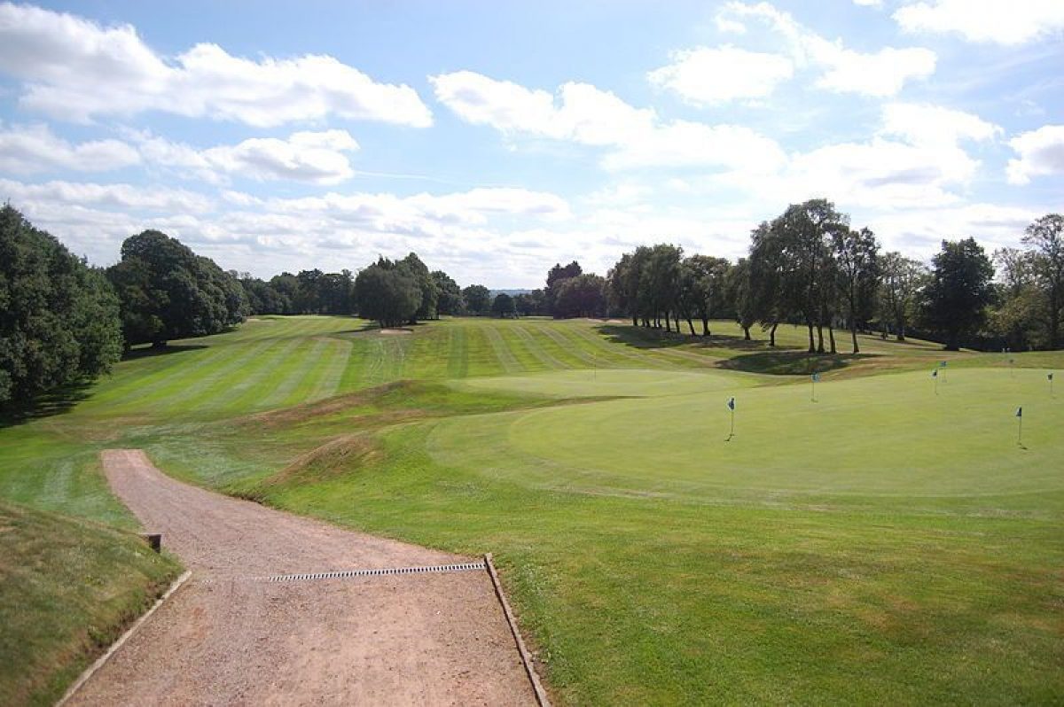
The Hall stands at the north end of the park with panoramic views east, west and south, both across the north-eastern third of the park and to the surrounding suburbs of Birmingham and the city centre beyond. From the Hall the immediate prospect is across the northern part of the park, a tongue of land c 400m long from north to south and 300m wide. Several lines of mainly silver birch run towards the Hall, dividing the managed grass of the fairways and the various greens. From the edges of this tongue the land falls away quite steeply, especially to the west into the valley of the Chad Brook wherein lies the Great Pool. At least at ground level the Great Pool, the main feature of the west side of the park, is invisible until the sunk fence is reached c 50m south-west of the Hall. From this point there was until the C20 a striking view over that lake, now largely screened by trees around its north-eastern fringes.
The Great Pool is c 500m long and 250m wide, and is fed by the Chad Brook. It is retained by a causeway-like, brick-walled dam at its south end. The dam has been more prominent since the lake's water level was lowered in the C20 and the north end of the lake drained to create the thirteenth fairway.
Virtually the whole of the park is given over to the golf course, although various mature parkland trees still survive. There are dense plantation belts, with much oak, around almost all of the perimeter.
Toll Gate House (in 1828 a school) stands at the north end of the park, south-east of the church on Priory Road, the former Worcester to Birmingham turnpike road. It was rebuilt after being destroyed during the Second World War.
On the stream leading south from the lake, 200m from its south-east corner, are the brick ruins of Over Mill. Already in existence by 1557 it later - perhaps before 1624 - became a blade mill. It remained a rolling mill until the later C19. Millstones have been reutilised as steps across the stream on the sixth fairway. To the north of the mill ruins are the remains of Spurrier's Pool, the old mill pool.
A map of 1701 shows that already by that date the 19 acre (c 8ha) tongue of land running south from the Hall was denoted Little Park. By 1718 the Great Pool was in existence, with Blade Mill Pool to the south, and in 1719, two years after purchasing the Edgbaston estate, Sir Richard Gough inclosed Edgbaston park and stocked it with deer. Beighton's view of the Hall and its surrounds c 1730 (in Dugdale 1730) shows an avenue approaching the south-east front, from the park. Lancelot Brown (1716-83) sent Sir Henry Gough 'plans for general alterations' (Stroud 1975, 224) in January 1776. Quite what these were is unknown, and hence the extent to which the C19 and C20 landscape was moulded by him. A map of 1787 showing the Great Pool and individual parkland trees, suggests however that any changes were probably superficial. The only substantial, and undated, C18 alteration was the closure of Priory Road c 400m south-east of the church; in 1701 this had continued around the south-east corner of the park. In the later C18 the demesne and park extended to 101 acres (c 42ha).
In 1936 the tenancy of the Hall and park was taken by Edgbaston Golf Club, who also acquired a 300m wide tract of land along the south-east side of the park including Park Mount, an early C19 villa. A course was laid out to a design by H S Harrison, the Golf Architect of the firm of Colt, Alison & Morrison. The landscaping work included planting trees and shrubs along the Bristol Road boundary, the new southern limit of the park, and the introduction of hundreds of self-seeded silver birches from other golf courses.
KITCHEN GARDEN
On low ground some 100m west of the Hall, against the boundary of the park, are the east, west and north walls of the former kitchen garden, of C18 and C19 date. The area within is now used as a golf practice ground.
REFERENCES
W Dugdale, Antiquities of Warwickshire II, (1730), pp 894-6 and figure
The Victoria History of the County of Warwickshire 7, (1964), pp 67-8, 266
D Stroud, Capability Brown (1975), p 224
P Heath, Towards One Hundred Years. Edgbaston Golf Course 1896-1986, (privately printed 1986)
Maps
Beilby, Knott & Beilby, Map of Birmingham, 1828
OS 25" to 1 mile:
1st edition published 1890
2nd edition published 1904
3rd edition published 1917
1945 edition
Archival items
The following are held at Birmingham Reference Library: maps of Edgbaston Hall and demesnes 1701, 1718, 1787; Calthorpe estate records including (box 3) building accounts of 1750s; list of documents relating to Edgbaston Hall and Park (c 1997 re Lottery Bid)
Description written: 1997
Register Inspector: PAS
Edited: October 1999
- Visitor Access, Directions & Contacts
Telephone
0121 454 1736Directions
The Vale, Edgbaston, south Birmingham
- History
The following is from the Register of Parks and Gardens of Special Historic Interest. For the most up-to-date Register entry, please visit the The National Heritage List for England (NHLE):
www.historicengland.org.uk/listing/the-list
HISTORIC DEVELOPMENT
In the later C14 the Middlemores acquired the manor of Edgbaston by marriage. It remained in their possession for 300 years although they were dispossessed during the Civil War when the Hall was garrisoned for Parliament by Colonel John Fox. At the Restoration the 1700 acre (c 700ha) estate was returned to Mary, the Middlemore heiress, and her husband Sir John Gage, 'a noted Roman Catholic' (quoted in Heath 1986, 67). In 1688 the Gages' religious beliefs lead to the Hall being burnt by a force of northern troops under Lord Delamere. On the death of Lady Gage the Middlemore inheritance was divided between her two daughters, Edgbaston passing to Bridget, the wife of Thomas Belasyse, Lord Fauconberg. In 1717 they sold the manor to Sir Richard Gough, a wealthy merchant and director of the East India Company, who proceeded to rebuild the still ruinous Hall, impark it, and in 1725 reconstruct the adjoining parish church.
The Goughs retained the estate and lived at Edgbaston for most of the C18, and in 1776 Sir Henry Gough, the grandson of the imparker, brought in Lancelot Brown to suggest improvements. Six years later however he married Barbara Calthorpe, and although the Gough-Calthorpes (later the Calthorpe Estate), still retained the estate in 1997, they never again resided at Edgbaston, prefering homes brought to the family by Barbara in 1783. The Hall stood empty until 1786 when a fourteen-year lease was granted to Dr William Withering (d 1799), a physician and botanist who discovered the propitious effects of digitalis. Later tenants included another doctor, a solicitor, and leading local politicians. In 1936 Edgbaston Golf Club took the tenancy; the Hall became the clubhouse, and the park was laid out as a golf course, which it remained in 1997.
Period
- 18th Century (1701 to 1800)
- Late 18th Century (1767 to 1800)
- Associated People
- Features & Designations
Designations
The National Heritage List for England: Register of Parks and Gardens
- Reference: GD2207
- Grade: II
Features
- Lake
- Tree Feature
- Hall (featured building)
- Now Clubhouse
- Earliest Date:
- Latest Date:
- Key Information
Type
Park
Purpose
Recreational/sport
Principal Building
Commercial
Period
18th Century (1701 to 1800)
Survival
Part: ground/below ground level remains
Hectares
47
Open to the public
Yes
Electoral Ward
Edgbaston
- References
References
- {English Heritage Register of Parks and Gardens of Special Historic Interest}, (Swindon: English Heritage, 2008) [on CD-ROM] Historic England Register of Parks and Gardens of Special Historic Interest
- Stroud, D., {Capability Brown} (London: Faber, 1975), p. 224 Capability Brown
- {Victoria History of the County of Warwickshire Volume 7} ([n.p.]: [n.pub], 1964), pp. 67-8, 266 Victoria County History: Warwick, Volume 7