Introduction
Dunorlan Park has a garden of 27 hectares laid out in the 1850s and 1860s by Robert Marnock to surround the Italianate style mansion of the same date. Its features include broad lawns, a cedar avenue, mature trees, a lake and ornamental pool with elaborate fountain and a temple housing a marble statue and several 'Pulhamite' rock features. The house was demolished during the mid-20th century and the gardens were substantially restored in the early-21st century.
Terrain
The pleasure grounds and park are laid out on sloping ground which falls from the ridge along the north end of the site down to the south-east, before rising again to the south-west.The lake at the base of the grassy slopes is used for boating and canoeing, and supports ornamental waterfowl. Its irregular outline supplies an interesting perimeter walk and the islands for the nesting birds provide additional interest. A small cafe near the upper car park provides simple fare during the day-time.
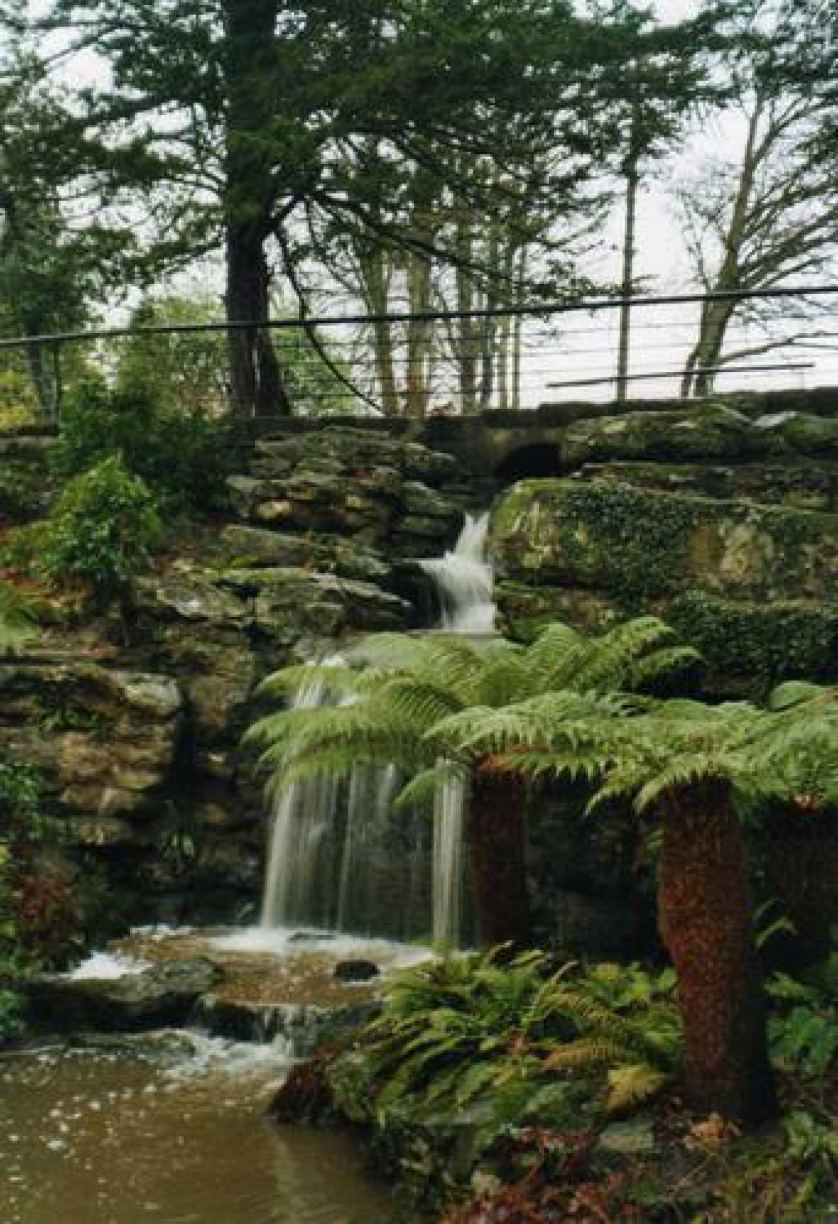
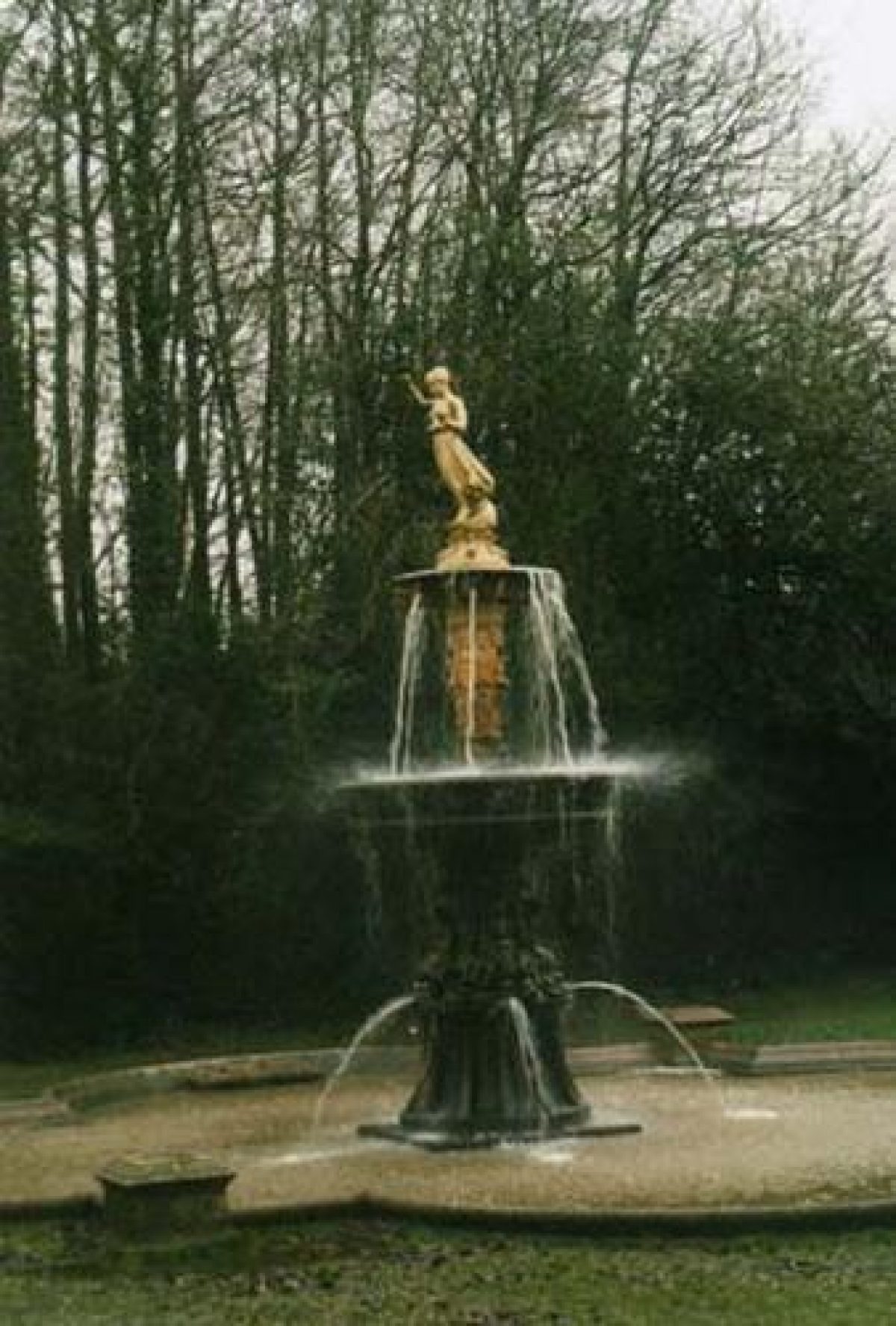
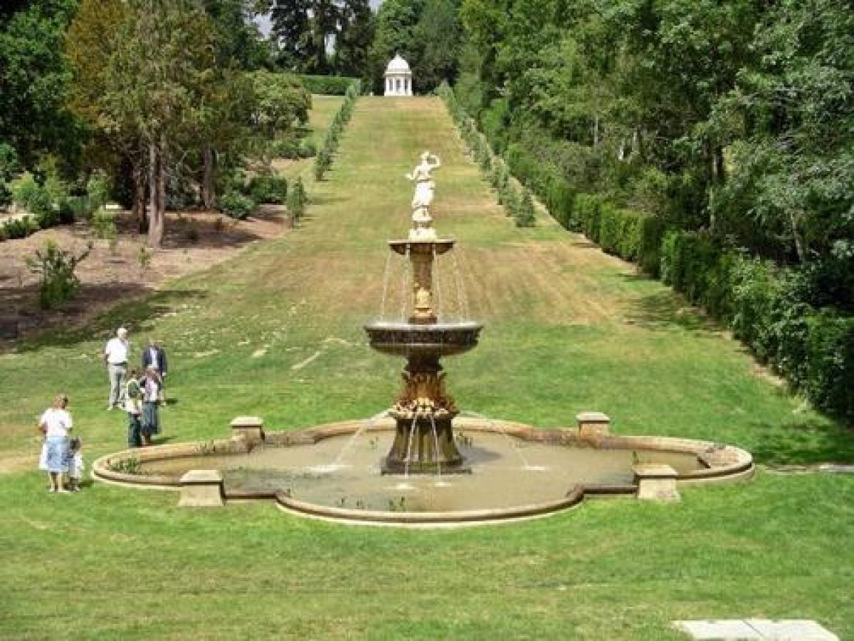
On the eastern side of the lake is a shrubbery/rock garden with small pond and stream and associated walkways. A complete contrast to this informality has been created with a fine avenue of alternate deodars and douglas firs (15 metres wide and 236 metres long). At the bottom end of the avenue is an ornamental pool with a central, elaborate fountain (now in disrepair). At the other end, and at the top of the hill, is a temple housing a marble statue ‘The Dancing Girl'.
The old kitchen gardens and formal gardens associated with the mansion have all been swept away. The upper part of the park is now privately owned and contains some modern housing.
The following is from the Register of Parks and Gardens of Special Historic Interest. For the most up-to-date Register entry, please visit the The National Heritage List for England (NHLE):
www.historicengland.org.uk/listing/the-list
Mid-19th-century pleasure grounds and park laid out by Robert Marnock, with water features by James Pulham.
DESCRIPTION
LOCATION, AREA, BOUNDARIES, LANDFORM, SETTING
Dunorlan Park is situated on the east side of Tunbridge Wells. The c 27ha site is located c 0.75km from the town centre, on the eastern edge of the built-up area, with residential areas to the north and west and the village of Hawkenbury to the south. The area here registered is bounded by Pembury Road (A264) to the north, private houses to the north-west and north-east, the grounds of Beechwood School to the east, Hall's Hole Road to the south-east, and Bayhall Road to the south-west. The pleasure grounds and park are laid out on sloping ground which falls from the ridge along the north end of the site down to the south-east, before rising again to the south-west. There are panoramic views from the north end of the site to the south and south-east. The boundaries are marked by a mixture of fencing types, with hedges along the south-east and south-west boundaries.
ENTRANCES AND APPROACHES
The main approach to the park is from Pembury Road to the north, through a C20 gate into a car-parking area. This approach was made in 2003/4 and lies to the west of the mid C19 approach, which still forms the entrance for the private housing on the site of the former house and kitchen garden. The original drive leads from the recessed entrance through gate piers and past a lodge to the east, and then curves south-eastwards for c 250m to the remains of the entrance forecourt on the north side of the C20 house which occupies the site of the mid C19 mansion (outside the boundary of the area here registered). The drive then turns to the north and returns to Pembury Road, enclosing the former north lawn (now with four mid to late C20 houses and their gardens). This area is outside the boundary of the site here registered. A further approach constructed in 2004 is from Hall's Hole Road to the south-east, from where a short drive leads to a car park.
PRINCIPAL BUILDINGS
The mid C19 Italianate house, Dunorlan House, for which the gardens were laid out, was demolished in 1958, following fire damage in 1946. A late C20 house has been built on the site of the C19 house. Its site lies outside the boundary of the area here registered.
GARDENS AND PLEASURE GROUNDS
The former house was situated on the balustraded Upper Terrace (outside the area registered here), from where there are extensive views to the south and south-east. To the north are the C20 houses built on the former north lawn (outside the boundary of the area here registered). To the east and south-east are the pleasure grounds with mature shrubberies of yew, holly, laurel, and rhododendron, and fine mature trees.
The retaining wall (listed Grade II) for the Upper Terrace has a double flight of steps (listed Grade II) with metal gates; these are now closed but prior to the mid C20 led down from the Upper Terrace and Dunorlan House to a grass terrace, the Lower Terrace, which skirts the foot of the Upper Terrace. A chalybeate spring situated c 10m south of the Lower Terrace is enclosed by grass banks and partly surrounded by planting.
From the east end of the Lower Terrace one path leads north-east to the north end of the pleasure grounds while another, the main north/south path, leads south-east and serpentines down to the lake. At the north end of the pleasure grounds there is a small, octagonal, mid C19 temple built in Grecian style (listed Grade II). During the 2003/4 restoration, the interior of the temple was found to have intricate painted design, based on the design of the ancient Greeks was uncovered. The temple terminates the northern end of a long vista along an avenue which runs along the north-east boundary. In 2004, the mid C19 avenue of alternating cedars and Douglas fir, was replaced by a new planting of 48 cedars. The view leads along the sloping ground down the avenue to an ornamental fountain. Along the avenue are plinths which mark all but one of the sites of the statues that formerly lined it. The fountain (listed Grade II) comprises a Pulhamite quatrefoil basin, pedestal and lower bowl and a terractotta pedestal and upper bowl. The fountain was fully restored in 2004.
To the west side of the avenue is a small rockery (probably by James Pulham; listed Grade II)) and the remains of a rose garden. These adjoin the main north/south path from the Lower Terrace which leads down to the east end of the lake and then continues for c 50m where it divides. One branch turns west and then curves south-west to run parallel with the east bank of the lake, and the other continues south-east and then turns south-west to run along the boundary with Hall's Hole Road. The path around the east bank of the lake runs through a water garden fed by water from the lake. The water flows over a cascade (listed Grade II) constructed on the back face of the dam for the lake, down to a pond which is partly edged with Pulhamite rockwork. At the western end of the water garden, steps lead up alongside the cascade to the lake and at the eastern end there are stepping stones (listed Grade II) set across the outlet from the pond, which lead back to the main north/south path. An octagonal plinth standing c 25m north-east of the cascade is all that remains of a summerhouse which overlooked the water garden. The moulded Pulhamite footbridge at the eastern extremity of the stream is a listed building Grade II.
The pleasure grounds continue to the south-west of the water garden, to the eastern tip of the lake, where the water garden path and the boundary path lead south-west to the car park on the southern boundary. The path partly covers the remains of an icehouse which has been filled in. There is a boatstore constructed from gabions containing Kentish ragstone and having a zinc roof on the path at the point where it joins the east side of the car park.
PARK
A mid C19 park fence is set within the park to the north-west of the terraces. Sloping parkland sweeps around to the west and to the south of the terraces, down to the north side of the lake. The lake is roughly triangular in shape, with a long north-west shore and shorter banks along the south and east sides.
To the south of the lake the land gently rises up to the south-west corner of the park. This area of meadow ground is planted with parkland trees, in scattered groups or old boundary trees. To the north of the small Upper Pond, which flows into the south-west corner of the main lake, is a rectangular area of park which was added to the park by the Collins family; this contains a late C20 putting green.
Parkland sweeps up from the north-west shore of the lake to the southern end of the north car park. A C20 drive leads south-east from the car park for c 160m across gently falling ground, to the edge of the ridge on which the northern part of the grounds are laid out. From the edge of the ridge there are sweeping views south to the lake and beyond, and at this point the drive divides. One branch leads west for c 75m to a mid C20 cafe, and the other branch continues south for c 100m down to the lake edge, where it terminates at a new (2004) wooden building. The cafe is situated on the edge of the ridge and has a broad terrace which rests on piers along the south side, overlooking the park.
The design for Dunorlan was in Marnock's `pictorial gardenesque' style (V Hinze pers comm, 2001) and was planted predominantly with exotic planting planned for colour, bold effect, and botanical variety. The trees and shrubs were grouped on the sweeping lawns, positioned to control and exploit the views. The design has been little altered and many fine trees survive within the pleasure grounds and the park including large, mature specimens or groups of oak, lime, sweet chestnut, beech, Scots pine, and sycamore, along with mature cedar, deciduous cypress, deodars, and Ponderosa pine specimens.
KITCHEN GARDEN
The remains of the mid C19 walled kitchen garden (outside the boundary of the area registered here) lie c 220m south-east of the mid C20 entrance from the north, and immediately north-east of the site of the mid C19 house. The kitchen garden was developed in the late C20 for private housing.
REFERENCES
Gardeners' Chronicle, ii (1881), pp 526-7, 532-3
Journal of Horticulture and Cottage Gardener 54, (1875), pp 364-6
Dunorlan Park, Royal Tunbridge Wells: Restoration Management Plan, (Scott Wilson 1999)
Marnock's Planting style and Dunorlan Park: Outline report, (Landscape Ecology 2001)
Maps [all reproduced in Scott Wilson 1999]
Plan of the Calverley Estate, around 1829
T Stidolph, A Map of Tunbridge Wells, 1838
Plan of the Dunorlan Estate, Tunbridge Wells, 1871 (Sale plan)
OS 6" to 1 mile: 1930 edition
OS 25" to 1 mile: 1st edition published 1872
Description written: February 2002
Amended: April 2002
Edited: November 2002
- Visitor Access, Directions & Contacts
Telephone
01892 554031Access contact details
This is a municipal park for general public use.
Directions
The site is directly south of the A264, on the eastern outskirts of Tunbridge Wells.
Owners
Tunbridge Wells Borough Council
Town Hall, Royal Tunbridge Wells, Kent, TN1 1RS
- History
A mid-l9th century Italianate mansion was demolished in the mid-20th century (picture in Journal of Horticulture and Cottage Gardeners, 21st October 1875). A landscape garden was laid out by a Mr Marnock in the 1850s and 1860s. He exploited the natural topography of the site to create a view from the terrace, of parkland sweeping down to the lake. The resulting broad lawns, fine cedar avenue, pines, oaks and copper beeches have now matured to prime condition.
Dunorlan Park was purchased by Tunbridge Wells Borough Council in 1945.
The following is from the Register of Parks and Gardens of Special Historic Interest. For the most up-to-date Register entry, please visit the The National Heritage List for England (NHLE):
www.historicengland.org.uk/listing/the-list
HISTORIC DEVELOPMENT
In 1823, John Ward, a partner of Decimus Burton (1800-81) in the development of the villas in nearby Calverley Park (see the description of this site elsewhere in the Register), bought Calverley Manor Farm, which included the site of a mineral (chalybeate) spring. He made a lake on the farm for recreational use (Stidolph, around 1838). He then sold the farm in 1854 to Henry Reed who demolished the farmhouse and built a new house, Dunorlan, in Italianate style. The site of the house was high on the ridge, positioned to take advantage of the fine views. Reed engaged Robert Marnock (1800-89) to lay out the grounds, including forming lawns, planting shrubberies and exotic trees, and forming a park by the removal of field boundaries and the addition of groups of trees. James Pulham was commissioned to provide Pulhamite rockwork and a Pulhamite and terracotta fountain. He also probably extended and reshaped the lake.
Henry Reed sold Dunorlan to the Collins family in 1874 and it remained in their ownership until 1945. Tunbridge Wells Borough Council purchased the site in 1945, by which time some of the statues and other features had been removed or destroyed. The Council made some changes to adapt the park to public use and put in new entrances, lavatories, a cafe, and two car parks. The house, which had been badly damaged by a fire in 1946, was demolished in 1958. The site of the house, together with the kitchen gardens and the former main entrance and drive, was sold to private developers. Eight houses were built on the site, including one on the site of the 19th-century house. Most of Marnock's design and many of the mid-19th-century features survive within the public park. The pleasure grounds and park are in the ownership of Tunbridge Wells Borough Council (2002). The houses (outside the area here registered) are in separate private ownership.
Period
- Post Medieval (1540 to 1901)
- Victorian (1837-1901)
- Associated People
- Features & Designations
Designations
The National Heritage List for England: Register of Parks and Gardens
- Reference: GD5127
- Grade: II
Features
- Boating Lake
- Description: The lake at the base of the grassy slopes is used for boating and canoeing, and supports ornamental waterfowl.
- Pool
- Description: At the bottom end of the avenue is an ornamental pool with a central, elaborate fountain (now in disrepair).
- Temple
- Description: At the other end, and at the top of the hill, is a temple housing a marble statue 'The Dancing Girl'.
- Fountain
- Description: At the bottom end of the avenue is an ornamental pool with a central, elaborate fountain (now in disrepair).
- Avenue
- Description: There is a fine avenue of alternate deodars and douglas firs (15 metres wide and 236 metres long).
- House (featured building)
- Description: The house was demaged by fire in 1946 and demolished in 1958.
- Earliest Date:
- Latest Date:
- Pulhamite
- Description: Rock garden.
- Key Information
Type
Park
Purpose
Recreational/sport
Principal Building
Parks, Gardens And Urban Spaces
Period
Post Medieval (1540 to 1901)
Survival
Extant
Hectares
27
Open to the public
Yes
- References
References
- {English Heritage Register of Parks and Gardens of Special Historic Interest}, (Swindon: English Heritage, 2008) [on CD-ROM] Historic England Register of Parks and Gardens of Special Historic Interest
- Kent County Council Planning Department {The Kent Gardens Compendium} (Canterbury: Kent County Council, 1996) 47 The Kent Gardens Compendium
- Kent Gardens Trust {A Presentation of Parks: A survey of amenity parks and gardens in Kent} (Kent Gardens Trust) 29 A Presentation of Parks: A survey of amenity parks and gardens in Kent
- Hitching, C {Rock Landscapes: The Pulham Legacy} (Garden Art Press, 2012) Rock Landscapes: The Pulham Legacy
- {Dunorlan Park Restoration Plan} (1997) Dunorlan Park Restoration Plan
- ACTA {Dunorlan Park stage 2 HLF Bid} (2002) Dunorlan Park stage 2 HLF Bid
- ACTA {Dunorlan Park Maintenance and Management Plan} (2004) Dunorlan Park Maintenance and Management Plan
- Tunbridge Wells Borough Council {Dunorlan Park: Management Plan 2009-2015} (2009) Dunorlan Park: Management Plan 2009-2015
Contributors
Kent Gardens Trust