Introduction
Ditchingham Hall is set in an 18th-century landscape park which includes a lake and woodland covering 48 hectares. It has been considered that the landscape was designed by 'Capability' Brown. However, no documentary evidence has been found to support this theory.
Terrain
The Hall stands above and to the west of the valley of the Broome Beck, a tributary of the River Waveney; the ground falls to the east towards this stream which in the 18th century was dammed to form the sinuous lake.
The following is from the Register of Parks and Gardens of Special Historic Interest. For the most up-to-date Register entry, please visit the The National Heritage List for England (NHLE):
www.historicengland.org.uk/lis...
An early C18 hall remodelled at the beginning of the C20, set within a mid C18 landscape park and late C20 gardens for which Percy Cane gave advice in the early C20.
DESCRIPTION
LOCATION, AREA, BOUNDARIES, LANDFORM, SETTING
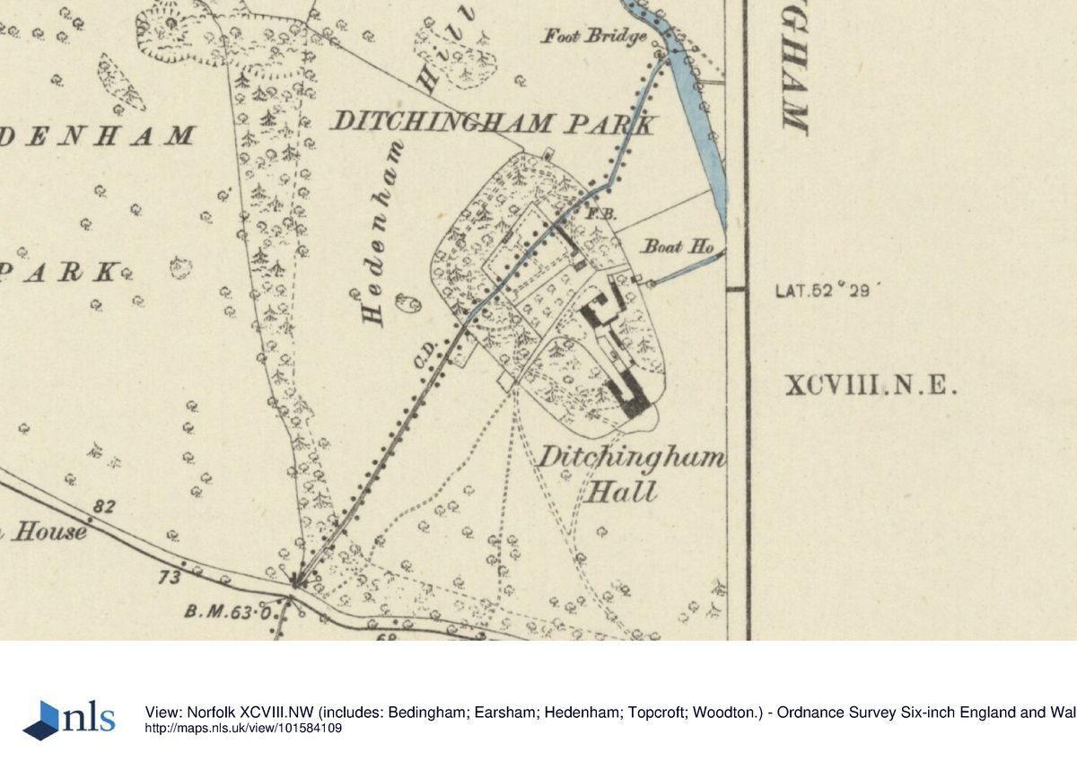
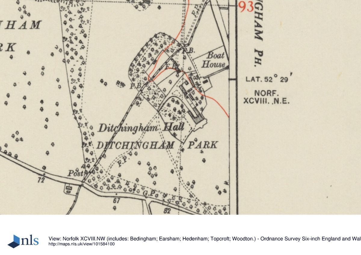
Ditchingham Park stands on the north side of the B1332 Norwich to Bungay road, c 4km to the north of the town of Bungay. The park covers c 48ha and is set in a rural, agricultural landscape on the Norfolk/Suffolk border. The Norwich Road forms the southern boundary with mid C18 boundary trees, much replanted in the mid C20, along its length. To the east the boundary is formed by the dense Lake Covert. The boundaries are more open to north and west, to the north running into farmland and in the west merging with the adjacent Hedenham Park. The Hall stands above and to the west of the valley of the Broome Beck, a tributary of the River Waveney; the ground falls to the east towards this stream which in the C18 was dammed to form the sinuous lake. There are fine views south-east from the Hall to the tower of Ditchingham church beyond the park boundary.
ENTRANCES AND APPROACHES
Ditchingham Hall is approached through a simple entrance c 300m to the south, through curved brick walls with tall gate piers topped by wrought-iron sculptures, all added in 1953. The lodges which stood opposite the entrance no longer survive. The drive, which is lined with lime trees planted partly in the early C20 and partly in the late C20, curves north-west and divides after c 100m, the western fork running to the stables at the rear (north) of the Hall and the eastern fork curving round to the gravelled entrance on the south-west front. During the C18 and C19 the drive ran north-east from the entrance, running through the park to arrive at the south-east front. The orientation was altered at the beginning of the C20 when the Hall was remodelled.
PRINCIPAL BUILDING
Ditchingham Hall (listed grade I) is a Classical-style country house of mauve brick with red-brick dressings under hipped slate roofs. It is built in a broadly U-shaped plan with two storeys and attics. The south facade, originally the entrance front, has seven bays with a central doorway and is part of the original early C18 house constructed by Rev John James Bedingfeld in c 1710. The entrance front, now on the south-west, was extended by Herbert J Green for William Carr in 1910 from five bays to nine in an Edwardian Baroque style which reflects the original parts of the building. The Edwardian service ranges to the north have been reduced in the late C20, the north-east arm now reduced to a single-storey summer-room with a hipped roof topped by a cupola. Mid C20 garden walls are attached to the north-west and south-west corners of the Hall, the north-west wall incorporating a gateway of panelled piers and finials hung with C17 wrought-iron gilded gates reused from Staunton Harold, Leicestershire.
A mid C19 single-storey L-shaped stable range lies c 80m to the north-west of the Hall. It is now (1999) converted to garaging and private dwellings.
GARDENS AND PLEASURE GROUNDS
The gardens and pleasure grounds at Ditchingham cover c 5ha and lie all around the Hall. The garden front is on the north-east which looks onto a steeply terraced area divided by hedges into small garden compartments. The lower of the two terraces comprises a long grass walk, bordered to the east by a ha-ha and terminated at its northern end by a brick and tile gazebo created through the restoration in the late C20 of an earlier outbuilding. These gardens have been created from the mid C20 onwards, although they reflect the series of formal gardens which lay here in the early C18. To the south-east is a terrace, laid to lawn and bordered by a balustrated wall which was built in the early C20, following which Percy Cane gave advice on the gardens (Webber 1975). Between the front and back drives on the south-west front is a large lawn with a very mature cedar of Lebanon. The lawn is backed to the north by a dense mixed shrubbery (mainly late C20).
The pleasure ground lies c 150m to the north and north-west of the Hall, completely encircling the walled garden. It includes some beech, oak, and yew of late C18 date, amidst much later mixed species tree and shrub replanting (late C20), through which a series of grass paths have been cut. This area also includes some surviving cedars from an area of the pleasure ground once known as the Cedar Walk.
PARK
The Hall at Ditchingham lies on high ground at the centre of its park, with views focused to the south and east. The park survives under grass although much of the timber has been lost since the late C19. The majority of parkland trees are oaks of late C18 to mid C19 date, with cedar of Lebanon close to the Hall. A few pre-park trees, all oak pollards, also survive. The most dramatic feature of the park is the c 800m long serpentine lake which runs from north-west to south-east to the east of the Hall. It contains two islands and is backed on the east side by a dense woodland, Lake Covert, probably of mid C18 origin (Faden, 1797). The southern end of the lake is crossed by a small bridge which leads to a simple gothic cottage. The western section of the park is slightly more heavily treed with no distinct boundary between the parks of Ditchingham and Hedenham.
KITCHEN GARDEN
The late C18 walled kitchen garden lies c 100m to the north-north-west of the Hall. The kitchen garden retains its north and east walls, the remainder being replaced by beech hedges. A small drain in the form of a watercourse runs from the northern end of the lake, south-west through the pleasure ground and the walled garden to exit in the south-west corner of the park. The east wall of the kitchen garden is pierced by a low brick arch under which the stream flows, whilst the beech hedges are broken by wrought-iron gates, that in the south boundary being mid C17 gilded wrought iron reused from Staunton Harold. The west gate is a modern addition (late C20), also gilded wrought iron to complement its neighbour. The garden has been developed from the mid C20 onwards by the owners in collaboration with Notcutts Nurseries and contains a rose garden, shrubbery, twin herbaceous borders focused on a summerhouse set into the north wall, and an area for fruit and vegetables. The south-west corner retains one glasshouse and some C19 frames.
OTHER LAND
The Carr family purchased Ditchingham and Hedenham Halls at the end of the C19, from which point the two parks developed in tandem, connected by an oak-lined wide grass avenue which survives in part. The Hall at Hedenham is now in separate ownership but the parks remain in a single ownership and today (late C20) are managed as one unit.
REFERENCES
N Pevsner, The Buildings of England: North-west and South Norfolk (1962), p 135
R Webber, Percy Cane (1975), pp 91-3
J Kenworthy-Browne et al, Burke's and Savills Guide to Country Houses III, (1981), pp 104-6
Country Life, no 32 (10 August 1989), pp 66-9
J Garden History 11, (1991), nos 1 and 2, pp 34-7
T Williamson, The archaeology of the landscape park, BAR Brit Ser 268 (1998), p 227
Maps
Ditchingham Hall Farm, nd (c 1713), (MC 166/203 632 X 5), (Norfolk Record Office)
J Rumball, A rough plan of Hall, gardens, lawn, avenues, meadows and plantations, Ditchingham Hall, 1764 (private collection)
W Faden, A new topographical map of the county of Norfolk, 1797 (Norfolk Record Office)
Ditchingham Park enclosure map, 1816 (PC 12/7 P153), (Norfolk Record Office)
A Bryant, Map of the county of Norfolk, 1826 (Norfolk Record Office)
OS 6" to 1 mile:
1st edition published 1892
2nd edition published 1903
OS 25" to 1 mile: 2nd edition published 1903
Illustrations
James Butcher, engraving of Hall and park, 1778 (Norfolk Local Studies Library)
Websites
Phibbs, J, ‘Ditchingham Hall' in ‘A list of landscapes that have been attributed to Lancelot 'Capability' Brown' , accessed 12 January 2016 from http://johnphibbs.uk/wp-conten...
Archival items
The Carr family papers, including the Ditchingham archives, are held at the Norfolk Record Office.
Description written: October 1999 Amended: February 2000
Register Inspector: EMP
Edited: February 2001
The entry was enhanced in 2016.
- Visitor Access, Directions & Contacts
- History
The following is from the Register of Parks and Gardens of Special Historic Interest. For the most up-to-date Register entry, please visit the The National Heritage List for England (NHLE):
www.historicengland.org.uk/lis...
HISTORIC DEVELOPMENT
Ditchingham Hall was built around 1710 for the Rev John James Bedingfeld, to replace an old house with an enclosed garden on the same site (Williamson 1998), the estates of Ditchingham and neighbouring Hedenham having passed into the family's hands by marriage with the Bosards in the late C15. The new hall was given an extensive formal landscape of walled gardens and approach avenues. During the course of the C18 three generations of the Bedingfelds were responsible for the gradual remodelling of the landscape and were described in an estate survey by Joseph Rundall in 1764 as having devoted some effort to the setting of the house. By 1778 when it was illustrated by James Butcher (NLSL), it had become a fine open landscape park with an extensive serpentine lake.The present owners (1999) believed the park to have been the work of Lancelot Brown and although the landscape which survives today dates from Brown's period, as shown on Butcher's engraving of 1778, a search of the estate records found no evidence to support the claim. During the C19 the Bedingfeld family continued to make small changes to the park, including extensions to the south-east and the establishment of perimeter belts, although the exact details are not recorded. In 1885 the Bedingfelds sold the estate and it was purchased, along with the adjacent Hedenham Hall, by William Carr, an antiquary who wrote for the Dictionary of National Biography. Carr commissioned the architect Herbert J Green to enlarge the Hall in 1910 and to add a balustrated terrace on the south front, whilst the parks of Ditchingham and Hedenham were linked by an oak-lined drive. William Carr's daughter and her husband Lord Ferrers lived at Hedenham until Brigadier Carr's death in 1981 when they moved into Ditchingham, calling on the Norfolk architects Fielden and Mawson to renovate and reduce the size of the Hall. The lake was dredged and the pleasure grounds reclaimed. The site remains (1999) in single private ownership.
- Associated People
- Features & Designations
Designations
The National Heritage List for England: Register of Parks and Gardens
- Reference: GD1133
- Grade: II
Features
- Lake
- Kitchen Garden
- House (featured building)
- Earliest Date:
- Latest Date:
- Parkland
- Woodland
- Key Information
Type
Park
Purpose
Ornamental
Principal Building
Domestic / Residential
Survival
Extant
Hectares
48
Civil Parish
Ditchingham
- References
References
- {English Heritage Register of Parks and Gardens of Special Historic Interest}, (Swindon: English Heritage, 2008) [on CD-ROM] Historic England Register of Parks and Gardens of Special Historic Interest
- Kenworthy-Browne, J. et al, {Burke?s and Savills Guide to Country Houses, Vol. 3: East Anglia} (London: Burke?s Peerage, 1981), pp. 104-6 Burke's and Savills Guide to Country Houses, Vol 3: East Anglia
- Pevsner, N., {The Buildings of England: North-west and South Norfolk} (Harmondsworth: Penguin, 1962), p. 135 The Buildings of England: North-west and South Norfolk
- Related Documents