Introduction
Langley Park is an 18th-century park and woodland created by 'Capability' Brown, with central grounds around the house.
Terrain
The ground is virtually level in the north park and falls gently away south and west of the Hall.www.historicengland.org.uk/listing/the-list
A mid C18 hall by Matthew Brettingham set in a landscape park attributed to Lancelot Brown who drew up a plan for the north park in 1765, accompanied by mid C19 formal gardens now much simplified.
DESCRIPTION
LOCATION, AREA, BOUNDARIES, LANDFORM, SETTING
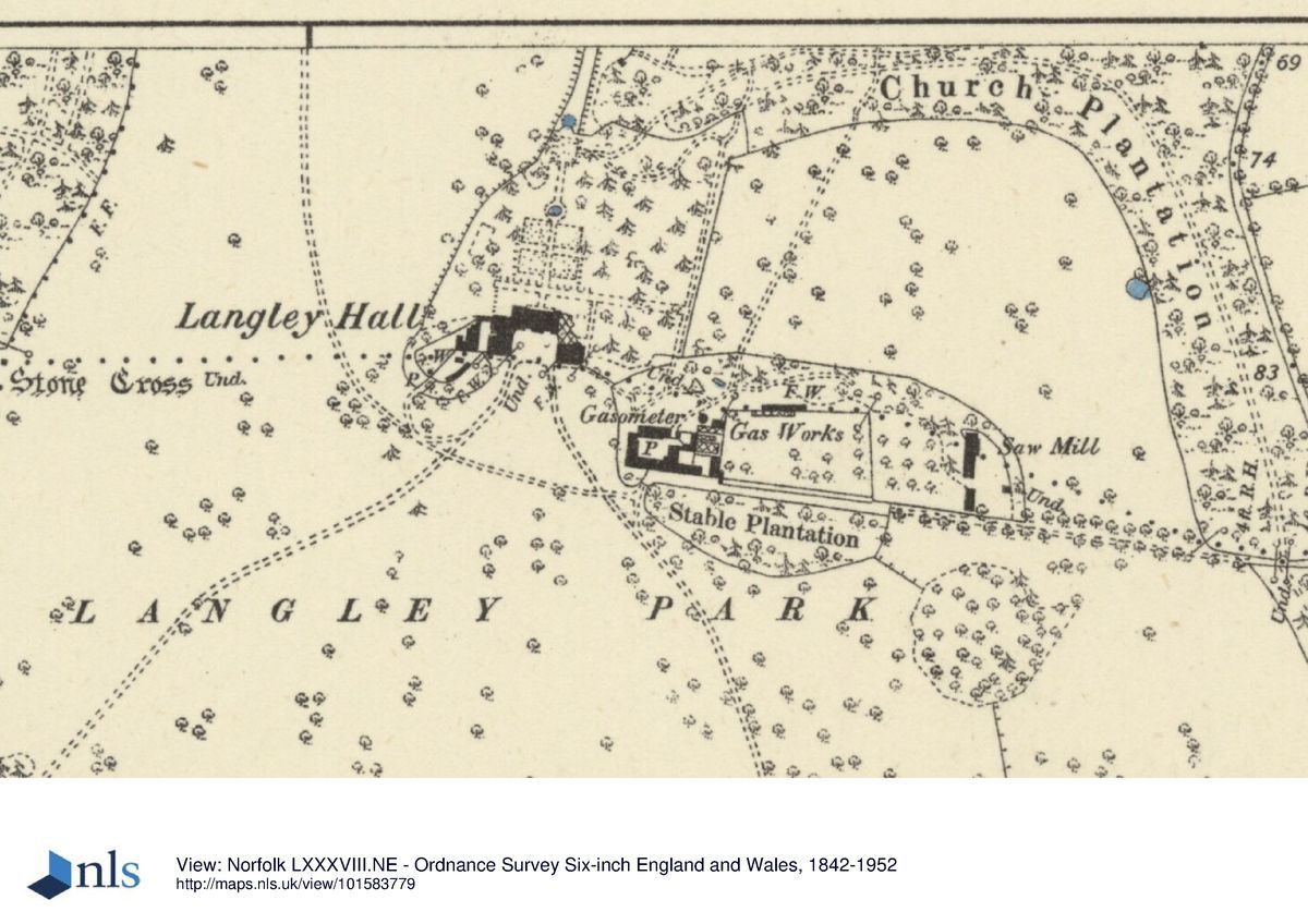
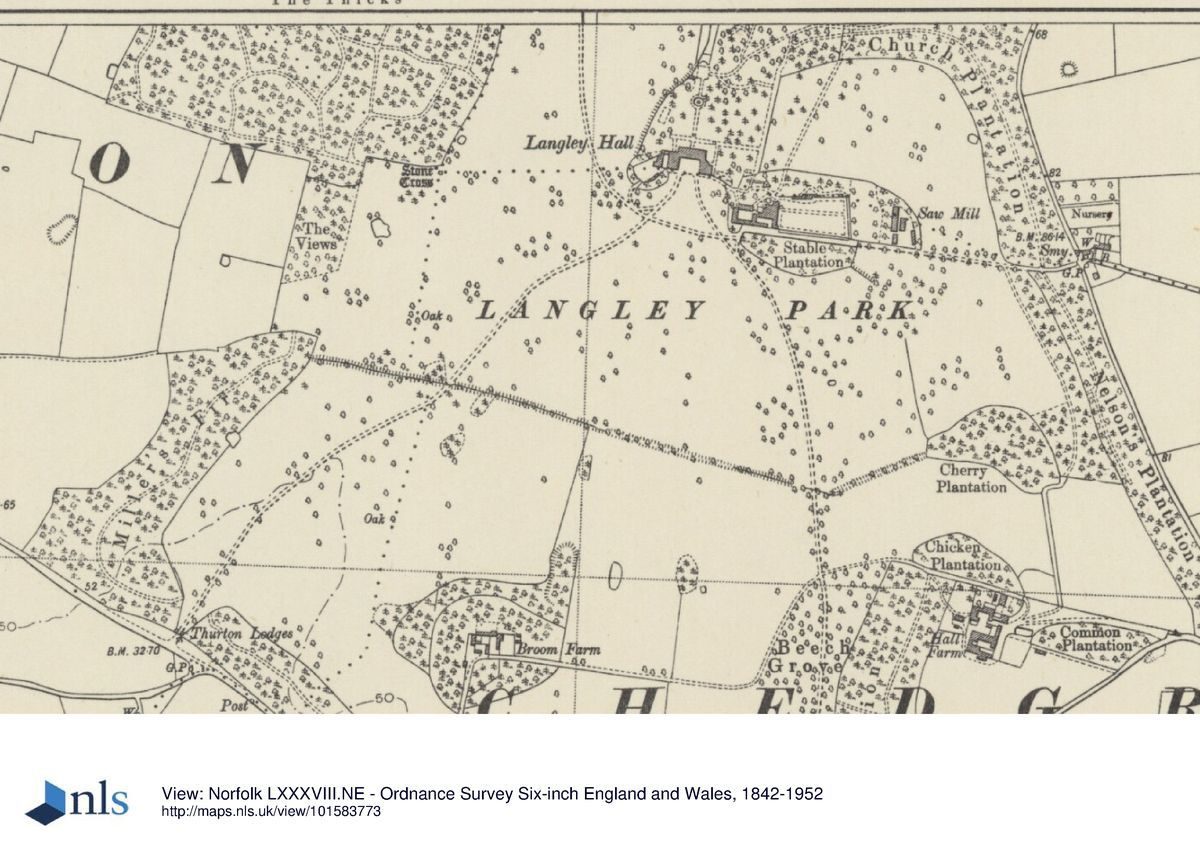
Langley Park lies in south-east Norfolk, on the north-east side of the A146 Norwich to Lowestoft road. Although it sits on the western fringes of the Norfolk Broads the character of the surrounding landscape does not reflect that of the Broads, being more undulating and well treed. The A146 forms the south-west boundary and minor country roads bound the park to the east and north. A dense plantation known as The Thicks backs onto farmland and forms the west boundary. In the south-east corner of the park lies Chedgrave village. Langley Park covers c 250ha including the gardens and woodlands. The ground is virtually level in the north park and falls gently away south and west of the Hall. Apart from a small section in the north-east corner perimeter belts enclose the park on all sides, thus closing views into the Hall and its landscape.
ENTRANCES AND APPROACHES
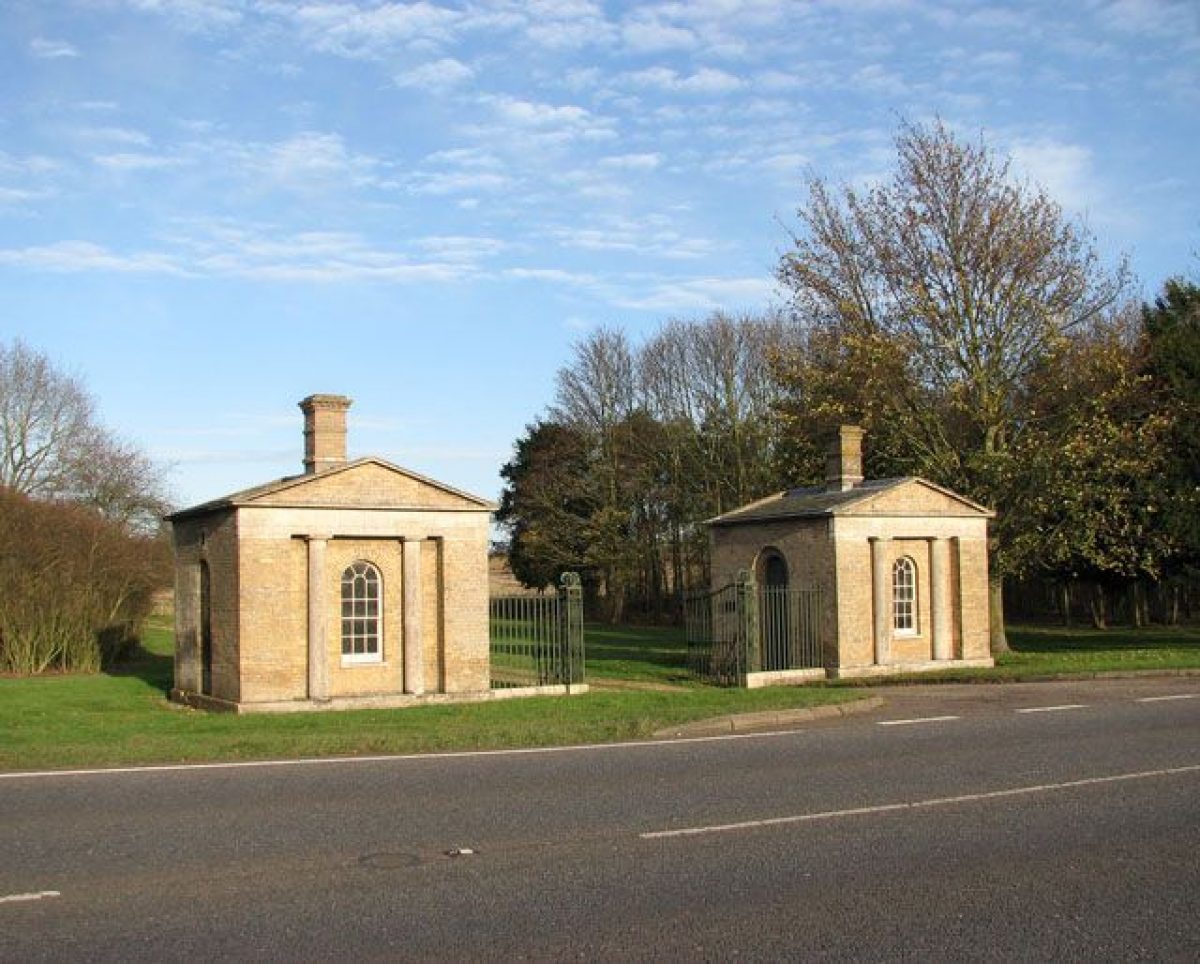
There are four entrances into the park at Langley. The main entrance for the Hall and school grounds lies along the eastern boundary, north of Chedgrave village. It enters the park c 650m east of the Hall, through an unmarked entrance and along a drive lined with mature sweet chestnut. The Thurton Lodges (listed grade II*), c 1km south-west of the Hall, and the Chedgrave Lodges (listed grade II*), c 1.2km south of the Hall, were both designed by John Soane in c 1785. The small Thurton Lodges are square, single-storey buildings of gault brick with Portland stone dressings under a slate roof. The Chedgrave Lodges, of the same materials, are more substantial, decorated with statues and joined by a brick arch overthrow. The two serpentine south drives originally led up to the south front of the Hall but both are now (1999) reduced to farm tracks. In the north-west corner of the park, c 1.3km to the north-north-west of the Hall, stands Carleton Lodge, a single-storey picturesque cottage of brick with white plaster and black beams under a thatched roof. The Carleton drive, now also a farm track (1999), winds through The Clumps wood and The Thicks wood before emerging in the park and continuing to the south front.
PRINCIPAL BUILDING
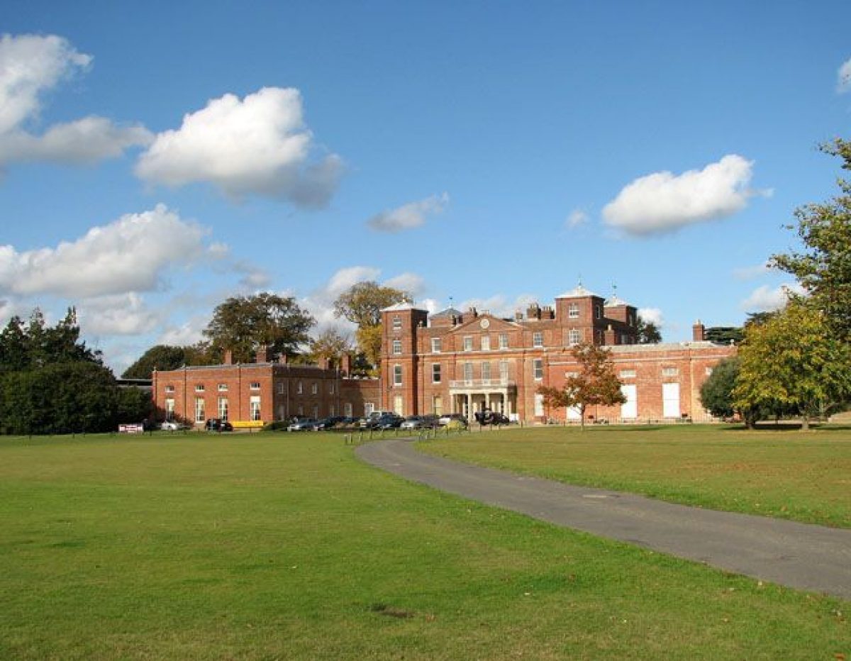
Langley Hall is a large Palladian mansion, now (1999) a school, built of red brick with lead and slate roofs. It sits in the centre of the park with which it originally had a strong north/south axial connection. The entrance front to the south has seven symmetrical bays, with the outer bays advanced and rising to four storeys to form square corner towers with pyramidal roofs and weathervane finials. To the south-east and south-west are two-storey square side wings of four bays, joined to the main house by short quadrant link blocks. The house was originally built in the 1730s for Richard Berney but was extensively remodelled by Matthew Brettingham the Elder in the 1740s for Sir William Beauchamp-Proctor. The architect Anthony Salvin (1799-1881) made further alterations in the early C19, when a Doric portico was added to the south front. In c 1870 a fine conservatory was added at the east end of the Hall but was demolished between the wars, leaving the grotto, which survives.
The stable courtyard is contemporary with the Brettingham house and lies c 100m to the south-east. It has been converted for use as school buildings and a new gate erected within the arched entrance (late C20).
GARDENS AND PLEASURE GROUNDS
The gardens and pleasure grounds lie to the north of the Hall where a long gravel terrace walk stretches the length of the north front, with central steps leading down to a sunken lawn now (1999) used as a grass tennis court. Beyond the tennis court is an early C20 circular pool with central fountain, flanked by mature cedar of Lebanon. Beyond the pool is the head of a narrow lake, running north away from the gardens. Steps into the lake are aligned on a door in the north front and these were originally connected by a gravel path which ran through the elaborate mid C19 formal garden that preceded the simple lawn. The circular pool is all that remains of this scheme. The lake is currently (1999) being dredged and refilled. On its eastern bank, c 200m north of the Hall, is a small hill below which the icehouse survives.
Some 200m to the north-east of the Hall is an arboretum laid out in the mid C19. Some notable mature trees survive including monkey puzzle, yew, and cedar of Lebanon and these have been added to in recent years by the school. Within the arboretum the remains of an early C20 wrought-iron gazebo survive and have recently been partly restored. The gardens and pleasure grounds are bordered to the north-east and north-west by a ha-ha, with the parkland beyond.
PARK
The park at Langley has mostly been returned to agriculture. Two small sections of pasture survive, one in the north-west corner beside Carleton Lodge and the other c 300m to the south-east of the Hall where a number of mature parkland trees also survive of mainly late C19 or early C20 date. The land immediately to the south of the Hall is given over to school playing fields, at the southern end of which the land falls away slightly and a row of mid C20 trees screen the modern (mid C20) Park Farm and White Lodge buildings. The older Broom Farm and its outbuildings lie in the south park, entirely enclosed by a dense woodland block. The north park is composed of arable land to the north-east and dense plantations to the north-west. Many of the boundary plantations appear to have a high conifer or sycamore content, following extensive clear-felling in the 1940s and 1950s.
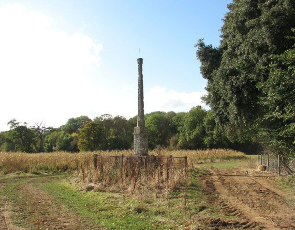
A medieval stone cross (listed grade II) on a circular red-brick plinth was placed in the park during the C19 at a point c 350m west of the Hall, to mark the point where four parishes meet. The base is engraved with the parish names of Chedgrave, Carleton, Langley, and Thurton. The shaft survives but the cross is missing.
KITCHEN GARDEN
The walled kitchen garden lies immediately to the east of the stable block and working yard, which once formed its enclosing west wall. Part of the north wall was blown down in the 1987 gale and has been rebuilt with modern brick. The gardener's cottage survives, incorporated in the north wall. The south wall was removed in the 1980s and a modern school building has been erected here (1990s). Hard tennis courts have been laid inside the walled area and the original glasshouses and apple store have been converted into a pottery workshop (1980s). The kitchen garden is of mid C18 origin, the majority of the north wall surviving from that date, whilst the remains of the east and west walls are later and much repaired.
REFERENCES
Country Life, 62 (2 July 1927), pp 16-22
N Pevsner, The Buildings of England: North-west and South Norfolk (1962), pp 239-42
D Stroud, Capability Brown (1975), pp 129-31
J Garden History 11, (1991), nos 1 and 2, pp 73/4
T Williamson, The archaeology of the landscape park, BAR Brit Ser 268 (1998), pp 259/60
Maps
Estate map, c 1730 (private collection)
Lancelot Brown, Plan for Langley Park, 1765 (private collection)
W Faden, A new topographical map of the county of Norfolk, 1797 (Norfolk Record Office)
A map of the Langley Estate in the county of Norfolk, 1816 (DS 157 (34) Cab II), (Norfolk Record Office)
A Bryant, Map of the county of Norfolk, 1826 (Norfolk Record Office)
OS 6" to 1 mile:
1st edition published 1892
2nd edition published 1908
OS 25" to 1 mile: 2nd edition published 1906
Illustrations
Francis Wooton, George Proctor and friends in Langley Park, c 1742 (private collection)
Description written: September 1999
Register Inspector: EMP
Edited: March 2001
- Visitor Access, Directions & Contacts
- History
The following is from the Register of Parks and Gardens of Special Historic Interest. For the most up-to-date Register entry, please visit the The National Heritage List for England (NHLE):
www.historicengland.org.uk/listing/the-list
HISTORIC DEVELOPMENT
Langley Hall was built in the 1730s for Richard Berney on land previously belonging to Langley Abbey. It would appear to have been built on a virgin site, according to an undated map of c 1730 (private collection) which shows only enclosed fields in the area. The Hall was laid out with 9 acres (c 3.75ha) of gardens, a 25ha park, and axial avenues radiating north and south. The estate was purchased in 1738 by George Proctor who commissioned Matthew Brettingham to remodel the Hall. In 1745 the estate passed to Sir William Beauchamp-Proctor who completed the building work and, in 1765, commissioned Lancelot Brown (1716-83) to advise on the landscape. Brown's plan (private collection) shows only the area north of the Hall but it is thought his activities included alterations to the south park as well (Williamson 1998). In 1785 the architect John Soane (1753-1837) produced designs for new entrance lodges which were built to adorn the new serpentine drives shown on an estate map drawn in 1816 (NRO). The Beauchamp-Proctors made few changes to the park during the C19 although the southern part was under arable cultivation for much of this time, being returned to pasture only at the end of the century. The gardens to the north of the Hall were given an elaborate formal character during the mid C19. During the Second World War the Hall was used by the army, the park was ploughed, and the gardens simplified. After the war the Beauchamp-Proctor family sold the estate into divided ownership, the Hall and grounds being purchased by a private school and the remainder of the park and its lodges sold as separate lots. This remains the pattern of ownership today (1999).
- Associated People
- Features & Designations
Designations
The National Heritage List for England: Register of Parks and Gardens
- Reference: GD2009
- Grade: II
Features
- Hall (featured building)
- Description: The hall was built in the 1730s and was re-modelled after 1738 by Matthew Brettingham.
- Earliest Date:
- Latest Date:
- Plantation
- Description: A dense plantation known as The Thicks forms the west boundary.
- Parkland
- Woodland
- Key Information
Type
Park
Purpose
Recreational/sport
Principal Building
Domestic / Residential
Survival
Part: standing remains
Hectares
250
Open to the public
Yes
Civil Parish
Langley with
- References
References
- {English Heritage Register of Parks and Gardens of Special Historic Interest}, (Swindon: English Heritage, 2008) [on CD-ROM] Historic England Register of Parks and Gardens of Special Historic Interest
- Stroud, D., {Capability Brown} (London: Faber, 1975), pp. 129-31 Capability Brown
- Pevsner, N., {The Buildings of England: North-west and South Norfolk} (Harmondsworth: Penguin, 1962), pp. 239-42 The Buildings of England: North-west and South Norfolk
- Historic Land Management {Langley Park Conservation Statement} (2004) Langley Park Conservation Statement