Introduction
Corsham Court has 18th-century parkland featuring woodland and a lake, with 19th-century gardens close to the house.
The following is from the Register of Parks and Gardens of Special Historic Interest. For the most up-to-date Register entry, please visit The National Heritage List for England (NHLE):
A mid C18 park improved by Lancelot Brown c 1760 and Humphry Repton c 1800.
Location, Area, Boundaries, Landform and Setting
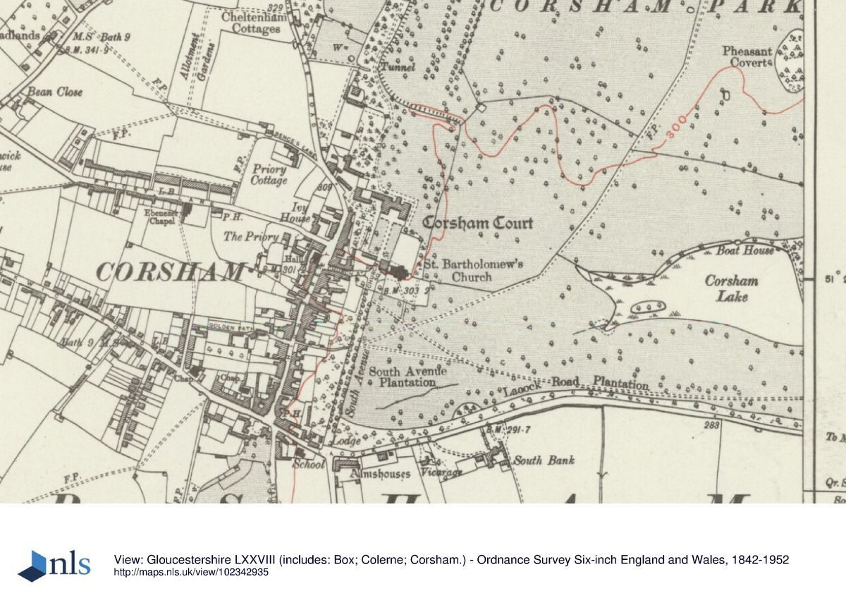
Corsham Court, a site of c 188ha, occupies a roughly square piece of level land situated immediately to the east of the town of Corsham. The park is surrounded to the north, west, and south by a wall dating from the C18 and early C19 (Pearson Assocs 1997). Along its southern boundary runs Lacock Road. To the north the site is bounded by the A4 between Bath and Chippenham. To the east the site is bounded by farmland and in the south-east corner, the village of Westrop.
Entrances and Approaches
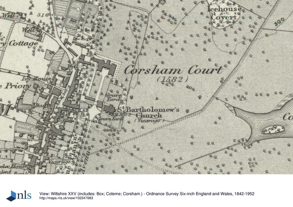
From the village of Corsham, the site can be approached via Church Street which leads to Church Square with St Bartholomew's Church and churchyard. To the north of Church Square a C17 arch (listed grade II*) gives access to a forecourt to the south of Corsham Court. The forecourt is enclosed by rubble-stone wall (listed grade II), possibly also of C17 date, and has a formal layout with a central path flanked on either side by a lawn with planted borders along the walls. In the south-east corner of the eastern lawn stands a mature cedar of Lebanon, and in the centre of the opposite lawn a large ginkgo.
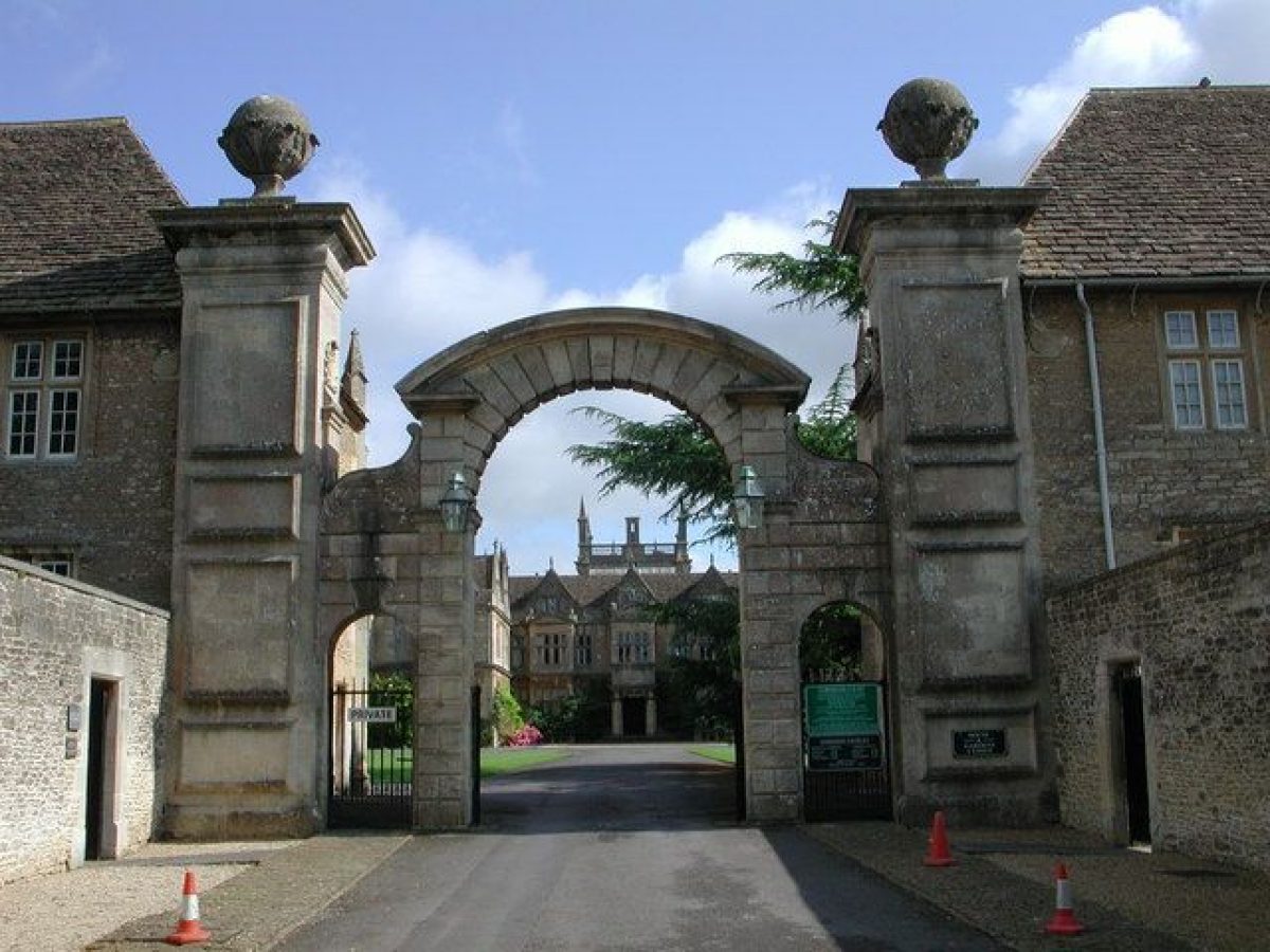
A pair of late C20 wooden gates hung between part C19 and part C18 gate piers (listed grade II), situated on Corsham High Street c 150 north-west of the Church Street approach, gives access to a drive that leads in a south-easterly direction to the south front of the house.
Two further entrances are situated on Lacock Road along the southern boundary of the site. In the far south-west corner gates and attached railings of c 1970, hung between early C18 gate piers (listed grade II), give access to the South Avenue that leads in a northerly direction towards Church Square. This entrance is flanked to its west by a mid to late C19 lodge in Tudor style (listed grade II). In the far south-east corner of the site is a gateway with two gate piers, flanked to the east by the mid to late C19 Westrop Lodge, built in Tudor style (listed grade II). This entrance gives access to a drive that leads along Lacock Plantation in a westerly direction through the park to Church Square; this forms part of Repton's new approach introduced in the late C18.
In the far north-east corner of the site a pair of late C20 wooden gates hung between two large early C18 rusticated gate piers with attached walls and two smaller gate piers (listed grade II*) gives access to a drive that leads through Mynte Wood in a south-westerly direction. This entrance is accompanied to its east by Mynte Lodge, introduced in the late C19 (OS 1889).
Principal Building
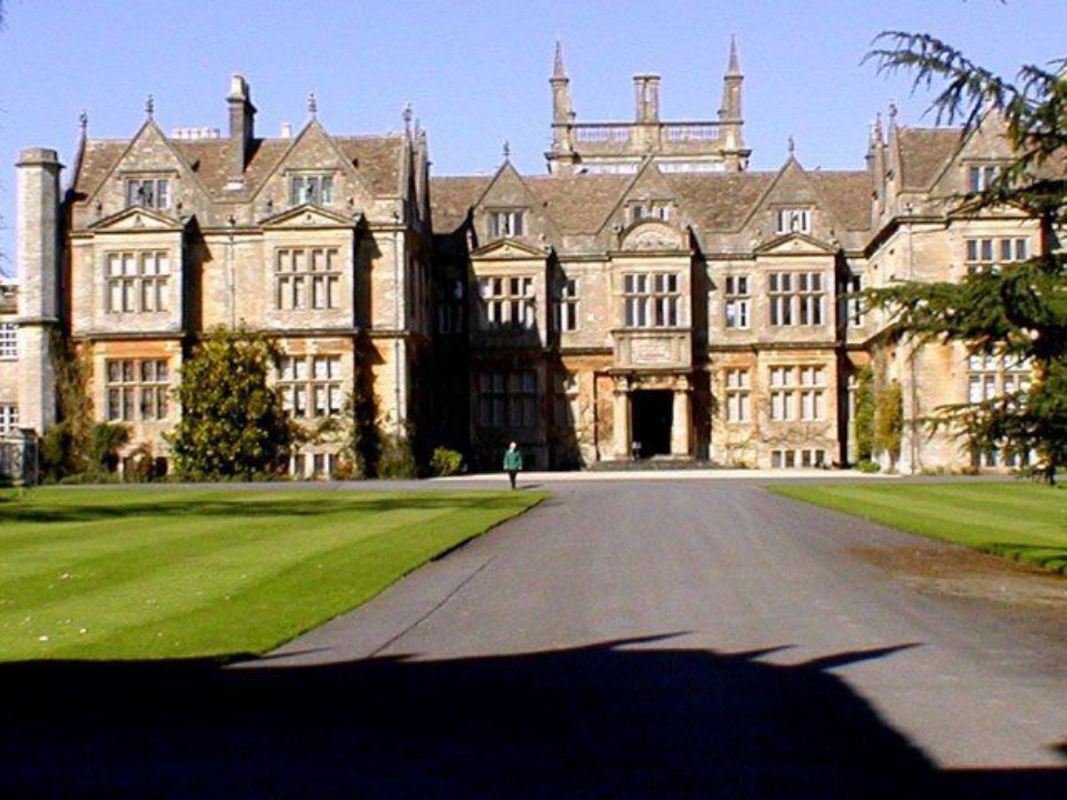
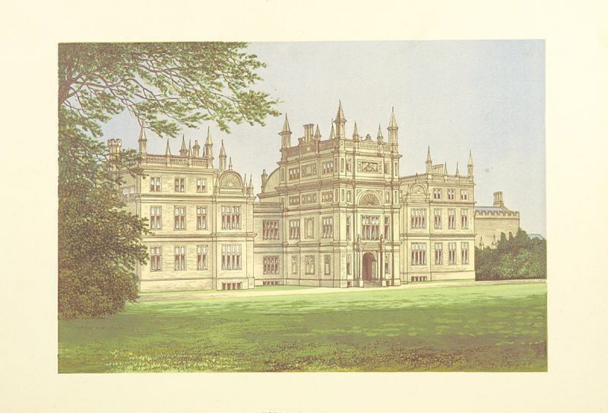
Corsham Court (listed grade I) is situated along the western boundary of the park. It is built of ashlar with a stone-tiled roof. The three-storey south front has three bays dating back to 1582, but was partly reconstructed by Lancelot Brown when he added the two outer bays c 1760. The two-storey east front, in Tudor style, mainly dates from 1801, when John Nash remodelled a Palladian-style façade by Brown. The north front, in Elizabethan style, was designed by Bellamy and has a projecting central tower. This front replaced one by Nash in Gothic style, which itself replaced a Palladian façade by Ireson. An octagonal dairy in Gothic style attached to the north-west end of the east front has survived from Nash's work. The west front, which includes the service wing, is similar to the south front and was reconstructed by Brown c 1760.
South of the house, at the opposite end of the forecourt, are the late C17 stables and riding school (listed grade II*), with to their west a coach house of c 1798 by Nash (listed grade II). Immediately to the west of the house lies the Old Laundry Cottage with attached range (listed grade II), with features possibly originating from the medieval house that stood on the site (demolished mid C16). To its north is a swimming pool introduced in the late C20, with beyond it to the north-west the estate yard which is surrounded by various C17 and C18 outbuildings (all listed grade II).
Gardens and Pleasure Grounds
The pleasure grounds are situated immediately to the north, east, and south-west of the house and are separated from the park to the north and east by a ha-ha, introduced by Brown in the mid C18, which to the north is crossed by two early C20 iron footbridges.
A small gate situated at the south-east corner of the house gives access to a path that leads around the rear of the building into the gardens. To the east of the house the garden is laid to lawn, with a large copper beech in its north-west corner. From this lawn there are extensive views of the park and the lake in the distance. The garden to the north of the house is also laid to lawn, allowing for the vista created by the North Avenue, situated in the park beyond a ha-ha, to continue. The lawn is flanked on either side by shrubberies which are crossed by a network of small paths and have a mixture of trees and shrubs planted mainly in the mid to late C19, including a mature oriental plane, wild cherries, magnolia, beech, and chestnuts.
To the north of the house is a formal garden with a central fountain, originating from the late C19 (OS 1889). It is flanked to the west and north by the walls of the kitchen garden. In the north corner of this garden stands the stone Bath House in Gothick style (listed grade I). Designed by Lancelot Brown c 1761-3, this was altered in 1797 and 1802 by John Nash. To the rear of the Bath House stands the Bradford Porch (listed grade II), a C20 summerhouse by E Tew incorporating late medieval stonework from The Priory in Bradford-on-Avon.
The path that runs along the east side of the Bath House continues in a northerly direction and is called the North Walk. It runs through a narrow plantation and then curves eastwards into Mynte Wood. From various points along the North Walk there are fine views of the park to its west and of Corsham Court to the south. Formerly, in the mid C18 (Plan of Corsham House and Grounds, 1745), the garden to the north of the house was enclosed and included a pond. The latter is also shown on Brown's plan of 1761, and is described in the key as a 'piece of water altered'.
To the west of the North Walk, north of the gardens, is an arboretum established in 1983 by Simon Pryce. It contains a large variety of exotic trees and shrubs and is laid out around a conduit-house, possibly dating to the C17 (listed grade II). To the south-east of the conduit-house is a late C18 cattle tunnel which leads into the west park.
The triangular garden to the south-west of Corsham Court is accessed via a gate in the west wall of the forecourt, and via the west entrance on Corsham High Street. The garden has a formal layout, now (2000) overgrown, and is dominated by large mature yew hedges clipped in rounded shapes (CL 1902). To its south, near the western stable block, is the Sham Ruin (listed grade II*), a late C18 folly. It comprises of a serpentine rubble-stone wall with applied ashlar features including a stack, a carved coat of arms with the date 1874, a bellcote, and pointed arches. It incorporates gothic stonework, some possibly medieval and some apparently mid C18, possibly taken from the Bath House. The Sham Ruin probably functioned as an eyecatcher to be viewed from the garden, but this view is now (2000) obscured by mature planting. The exact reason for its erection and its position near the stable block remains uncertain (Jones 1974).
Park
The park stretches out to the north, north-west, east, and south-east of Corsham Court. It is bounded to the south by Lacock Road Plantation, to the north-west by the Withy Bed, and to the east by Westrop Belt and Lake Cover (OS 1889). A circular walk, sections of which now (2000) form part of a public footpath, runs from Mynte Wood in a southerly direction into the eastern part of the park and through Lake Cover. There it turns west and leads onto a track along Lacock Road Plantation to the South Avenue. From various points along this walk there are fine views of Corsham Court and St Bartholomew's church. The walk forms part of Repton's perimeter ride, established c 1800 in order to create a new approach to Corsham Court (Map of the Manor of Corsham... , 1806).
The southern part of the park is dominated by South Avenue (replanted C20) and Corsham Lake. Formerly, in the early C18, the southern park was dominated by another avenue which ran in an easterly direction, as shown on the estate plan of c 1745. The South Avenue, also originating from the early C18 (estate plan, c 1745), is flanked to the west by a plantation which has a wall to its west which separates it from the rear gardens of the houses along Corsham High Street. Attached to this wall, halfway along its length, is an early C18 square gazebo with an ogee stone-tiled roof (listed grade II*).
Corsham Lake, created by Humphry Repton in the late C18, is situated in the south-east corner of the park and is screened to the east by Lake Cover. At its far south-east corner stands Lake House with an attached boathouse (c 1800, listed grade II).
The northern park is crossed by a double avenue, called the North Avenue (replanted in the C20), which originates from the early C18. To its west lies the North Walk, with Winters Close and Horse Shed Piece, both pasture land, beyond it (Tithe map, 1838). The park to the east of North Avenue has various clumps of mature trees including Pheasant Covert, formerly called the Oval Plantation (Corsham Parish Plan, 1820). The plan of c 1745 shows this part of the park as enclosed fields; Brown's plan of 1761 shows it as part of the park, this change being confirmed by Andrews and Drury's plan of 1773.
North of the North Walk and Mynte Wood lies Folly Farm (listed grade II), an estate farm dating from the C17 and C18. Its surrounding land, with the North Avenue continuing through it, is currently (2000) in pasture. Folly Farm and its land became part of the park when the road between Bath and Chippenham was diverted in the early C19 (Map of the Manor of Corsham, 1806; Corsham Parish Plan, 1820), and a new park wall was built further north. Formerly, in the mid C18, Folly Farm, then situated outside the park wall, was screened from the park by a plantation. The latter was removed in the late C18 by Humphrey Repton, who made the farm into an eyecatcher (Pearson Assocs 1997).
Kitchen Garden
The walled kitchen garden (listed grade II) probably dates from the early C18 and is situated c 20m to the north-west of the house. It is accessed via a path from the estate yard situated at its southern end, the path continuing along the west side of the kitchen garden, being in turn flanked to the west by an orchard. The rectangular garden is divided by an internal wall into two areas, with a smaller area attached to its north. Attached to the garden wall in the north-west corner is a gardener's cottage, dated 1877 (listed grade II as part of the wall). To the north, the wall extends eastwards into the pleasure ground, where it is attached to the rear of the Bradford Porch and the Bath House. The kitchen garden is laid out with a perimeter walk and contains glasshouses and potting sheds of various dates.
REFERENCES
Peacock's Polite Repository (July 1800)
H Repton, Observations on the Theory and Practice of Landscape Gardening (1803)
J P Neale, Views of the Seats (1829)
The Studio, (1907-08), plates xli, xlii [photographs showing the park entrance and rose garden]
C Holme, Gardens of England in Southern and Western Counties (1907), pp 41-3
Landscape and Garden 3, no 3 (1936), pp 149-52
Country Life, 12 (19 July 1902), pp 94-5; 82 (20 November 1937), pp 516-21; (27 November 1937), pp 548-54
B Jones, Follies & Grottoes (1974), p 407
F J Ladd, Architects at Corsham Court (1979)
J Sales, West Country Gardens (1980), pp 201-04
Lord Methuen, Corsham Court, guidebook, (1983)
D Stroud, Capability Brown (3rd edn 1984), pp 35, 86-90
Architectural History 27, (1984), p 388
T Hinde, Capability Brown (1986), pp 79-83
Wiltshire Gardens Trust Newsletter 15, (March 1987)
Corsham Park, Wiltshire - Historic Landscape Survey and Management Plan, (Nicholas Pearson Associates 1997)
Maps
- Plan showing Corsham House and Grounds, c 1745 (private collection)
- Greening, Plan for the garden at Corsham House, c 1747-9 (private collection)
- Oram, Plan for the grounds at Corsham House, c 1750 (private collection)
- Lancelot Brown, Plan showing both existing and proposed features at Corsham Court, 1761 (private collection)
- Andrews and Drury, Map of Wiltshire, 1773
- Map of the Manor of Corsham for Paul Cobb Methuen, 1806 (Wiltshire and Swindon Record Office)
- Corsham Parish Plan, 1820 (private collection)
- Tithe map for Corsham parish, 1838 (Wiltshire and Swindon Record Office)
- OS Old Series, 1" to 1 mile, published 1828
- OS 6" to 1 mile:
- 1st edition surveyed 1885, published 1889
- 2nd edition revised 1900, published 1902
- OS 25" to 1 mile:
- 1st edition surveyed 1885, published 1887
- 2nd edition revised 1900, published 1902
Illustrations
- T Hearne, Corsham House in Wiltshire, the Seat of Paul Methuen Esqr, 1784 (reproduced in Pearson Assocs 1997)
- A Robertson, Engraving showing east front of Corsham Court with the lake as created by Lancelot Brown in the foreground, 1792 (reproduced in Pearson Assocs 1997)
- Engraving after H Repton's drawing showing the view from the south end of The Lake (Peacock's Polite Repository 1800)
- R Havell, Engraving and aquatint showing The Lake and the east front of Corsham Court, 1816 (reproduced in Pearson Assocs 1997)
Archival items
- The Corsham Collection is held at the Wiltshire Record Office.
- Series of postcards and photographs of Corsham Park, early C20 (Wiltshire and Swindon Record Office)
Description written: October 2000
Amended: November 2003
Register Inspector: FDM
Edited: November 2004
- Visitor Access, Directions & Contacts
Telephone
01249 712214Website
https://www.corsham-court.co.uk/Access contact details
The garden is open all week except Mondays and Fridays from March to September, but only at weekends in the winter.
For more detailed visitor information, visit the Corsham Court website.
Directions
The site is close to junction 17 on the M4, some four miles west of Chippenham.
- History
The following is from the Register of Parks and Gardens of Special Historic Interest. For the most up-to-date Register entry, please visit The National Heritage List for England (NHLE):
HISTORIC DEVELOPMENT
Corsham was owned by the Crown during the medieval period and there was a park at that time, the earliest reference to which is in the Calender of Close Rolls of 1246 (Pearson Assocs 1997). Corsham is also briefly described in Leland's Itinerary for England and Wales 1535-1543 (ibid). In 1575 the Corsham estate was leased to Thomas Smythe (1522-91), Collector of the Customs of London; work on the present house began in 1582. In 1602 Corsham was sold to Sir Edward Hungerford, and the estate remained in his family until 1684. From that date the estate passed through several ownerships until it was bought by Robert Neal of Corsham c 1746, on behalf of Paul Methuen (1723-95). A plan of 1745, probably made in connection with the sale, shows the house with a forecourt to its south and an enclosed garden to its north, surrounded by a park with three radiating avenues and two ponds in its eastern part. In 1749 Paul Methuen decided to improve the estate, and the north front of the house was refaced in a classical manner, possibly to designs by Ireson, who also built Stourhead (qv) (ibid). Around the same time he consulted 'Greening', possibly the royal gardener Thomas Greening, who produced a plan for the pleasure garden c 1747-9 (ibid). In c 1750 Paul Methuen consulted another designer, called Oram; the latter also produced a plan including proposals for the park (c 1750). It is not known to what extent, if at all, the proposals as shown on the plans by Greening and Oram were implemented.
A decade later, Paul Methuen commissioned Lancelot Brown (1716-83) to work at Corsham Court (then known as Corsham House), both as architect and landscape gardener, which he did from 1760 to 1780. In 1761 Brown produced a plan of the park which shows both existing and proposed features. It is not certain which of Brown's proposals were executed, but his invoices for works undertaken at Corsham in 1761-2, and related correspondence between him and Paul Methuen, suggest that the north and south avenues were retained, a small lake was created from the existing ponds to the east of the house, a ha-ha or sunk fence was built around the pleasure ground, and a series of walks and rides was created around the park (Andrews and Drury, 1773).
After Paul Methuen's death in 1795, his son Paul Cobb Methuen inherited Corsham Court, and in the same year he commissioned Humphry Repton (1752-1818) to undertake landscape works, and John Nash (1752-1835) to alter and extend the house. Repton visited Corsham first in 1795, three times in 1796, and a further visit was undertaken by him in 1797. In that year, 1797, a Red Book for Corsham was produced at a cost of £42 (Pearson Assocs 1997). The location of the Red Book for Corsham is not known and it may not have survived but in his Observations on the Theory and Practice of Landscape Gardening published in 1803, Repton quotes from this Red Book. The alterations to the park following Repton's recommendations continued at least until 1801, and various contemporary prints, engravings, and a map of 1806 (Map of the Manor of Corsham for Paul Cobb Methuen), give an indication of the works carried out by Repton. These mainly included the laying out of a new approach drive, the removal of Brown's lake in order to create a larger one further from the house, and a programme of clearing, felling, and planting.
In 1816, after Paul Cobb Methuen's death, the Corsham estate passed to his son Paul (1779-1849). Under his ownership the layout of the park seems to have remained largely unaltered (Corsham Parish Plan, 1820), but in 1844 he commissioned Bellamy to replace John Nash's north front of the house. In 1849 the estate passed to Frederick Methuen (1818-91); under his ownership three new lodges were introduced and the park was extended to the north of the A4 (OS 1889). By the early to mid C20 this newly added piece of parkland north of the A4 had been returned to farmland (not included in the area here registered).
Corsham Court remains (2000) in private ownership.
- Associated People
- Features & Designations
Designations
The National Heritage List for England: Register of Parks and Gardens
- Reference: GD1439
- Grade: II*
Features
- Lake
- Wilderness
- House (featured building)
- Description: The house has been re-faced, altered and extended since it was built.
- Earliest Date:
- Parkland
- Woodland
- Gardens
- Key Information
Type
Park
Purpose
Ornamental
Principal Building
Domestic / Residential
Survival
Extant
Hectares
188
Open to the public
Yes
Civil Parish
Corsham
- References
References
- Repton. H., {Observations on the theory and practice of Landscape Gardening} (London: J. Taylor, 1803) Observations on the theory and practice of Landscape Gardening; including some remarks on Grecian and Gothic Architecture
- Sales, J., {West Country Gardens} (Gloucester: Alan Sutton, 1980), pp. 201-4 West Country gardens : the gardens of Gloucestershire, Avon, Somerset and Wiltshire
- {English Heritage Register of Parks and Gardens of Special Historic Interest}, (Swindon: English Heritage, 2008) [on CD-ROM] Historic England Register of Parks and Gardens of Special Historic Interest
- Stroud, D., {Capability Brown} (London: Faber, 3rd edition, 1984), pp. 35 and 86-90 Capability Brown
- Hinde, T., {Capability Brown: the story of a master gardener} (London: Hutchinson, 1986), pp. 79-83 Capability Brown: the story of a master gardener
- Home, C. (ed), {The Gardens of England in the southern and western counties} (London: The Offices of 'The Studio', 1907), pp. 41-3 The Gardens of England in the southern and western counties
- Nicholas Pearson Associates {Corsham Historic Landscape Survey/Management Plan} (1997) Corsham Historic Landscape Survey/Management Plan