Introduction
Great Chalfield Manor has an early-20th-century garden in the grounds of a moated manor house.
The following is from the Register of Parks and Gardens of Special Historic Interest. For the most up-to-date Register entry, please visit the The National Heritage List for England (NHLE):
www.historicengland.org.uk/listing/the-list
An early 20th-century terraced garden designed by Alfred Parsons incorporating a medieval fishpond, surrounding a late 15th-century Manor restored by Sir Harold Brakspear in the early 20th century.
Location, Area, Boundaries, Landform and Setting
Great Chalfield Manor, a site of c 8ha, is situated c 2km west of the village of Broughton Gifford, with the village of Holt c 2km to its south. The north boundary is formed by the upper moat or mill pond, which is fed by an ancient mill leat that runs along the north-west boundary of the site. The Chalfield Brook runs through the lower part of the garden in a south-easterly direction, below the spring-fed medieval fishpond.
The southern boundary is marked by a cobbled track lined by a beech hedge, situated to the south of the southern or lower moat. The track runs in south-easterly direction to meet the Holt road that runs along the east and north boundary of the site. The boundary along this road is marked by a garden wall with roll-top coping that links up with the C13 or C14 wall and bastions (listed grade II) to the north of the Manor.
The site has a rural setting, characterised by both pasture and ploughed land. Immediately to the north-west of the site lies Home Farm. The fields to the north of the site (outside the area here registered) still contain the C18 pattern of hedgerows recorded in 1794 (guidebook 1998), and in some places are planted with ornamental trees. The latter includes a clump of mature chestnuts to the west of the avenue, probably planted at a similar date to the planting of the drive and the construction of the north lodge c 1910.
Entrances and Approaches
The main approach to the site is along the avenue to the north of the Manor. The drive is c 1.5km long and is lined mainly with oak trees, many planted in the early C20. At the north end stands Brakspear's lodge of c 1910 (listed grade II). From the lodge, the drive leads in south-westerly direction to the Manor. Just over halfway along its length the avenue continues through the field while the drive curves slightly to the west before rejoining the main line of the avenue.
The drive ends at the Holt Road that runs along the north boundary of the site. Here it leads to a bridge with a stone gate built over the moat to the north of the Manor, which gives access to a gravelled entrance yard. On the west side of the entrance yard stands a C17 to mid C18 barn (listed grade I), now in use as a squash court, with beyond it the stables (listed grade II) designed by Brakspear c 1910.
To the east, the entrance yard is lined by a long C16 two-storey service wing which has at its northern end a gatehouse of earlier date. The latter gives access to the forecourt in front of the Manor. The forecourt is gravelled with grass verges along its perimeter.
On the east side of the forecourt, immediately to the north-east of the Manor, stands All Saints' church (listed grade I), which is surrounded by a small walled graveyard.
A secondary entrance to Great Chalfield Manor is situated in the south-east corner of the site. Here a wooden door in the boundary wall along the road from Holt gives access to the garden.
Principal Building
Great Chalfield Manor (listed grade I) is built of rubble stone and has a stone slate roof with ashlar quoins, dressings, and stacks. Its floor plan shows a central hall with four bays, flanked to the west by a family wing and to the east by a solar wing, each with an oriel window.
The two-storey north front has five windows with an entrance porch to the west. To the west, the Manor is linked to a two-storey range (possibly the former priest's accommodation) which is in turn linked to the long C16 service wing. The east wing, demolished in 1838 except for the north gable, was rebuilt by Brakspear in 1910. It contains the solar room on the first floor and has five arched windows which overlook the garden on this side.
The south front of the Manor embraces the former inner court: the foundations of the wing to the south have, since the early C20, been incorporated in the garden. The south front has three large arched windows and buttresses which form the rear of the hall. To the east is the rear of the solar wing with three arched windows and a doorway while to the west is a timber-framed wing, rebuilt c 1910, which has a five-bay loggia on wooden posts. Its gable end has arched windows, and attached to the south-west is another timber-framed wing of 1916.
In the far north-east corner of the site are the late C19 mill cottages (OS 1901), including a private garden to the south, which were added to a former corn mill (OS 1886).
Gardens and Pleasure Grounds
In the south-east corner of the forecourt a paved path leads into the main garden to the east of the Manor. The area immediately to the east of the house is formally laid out and has a square lawn bisected by a path; in the centre of each half stands a walnut tree. The central path leads to a quatrefoil-shaped pond which is flanked to the north and south by a group of mature yews, clipped in the shape of a four-pointed marquee c 4m high. To the north of this formal part of the garden lies the Church Border, which follows the line of the churchyard wall. To the east lies a rectangular-shaped lawn, formerly laid out as a croquet and tennis lawn (National Trust 1991-2). Here a raised grass walk, called the northern Moat Walk, runs along the north garden wall.
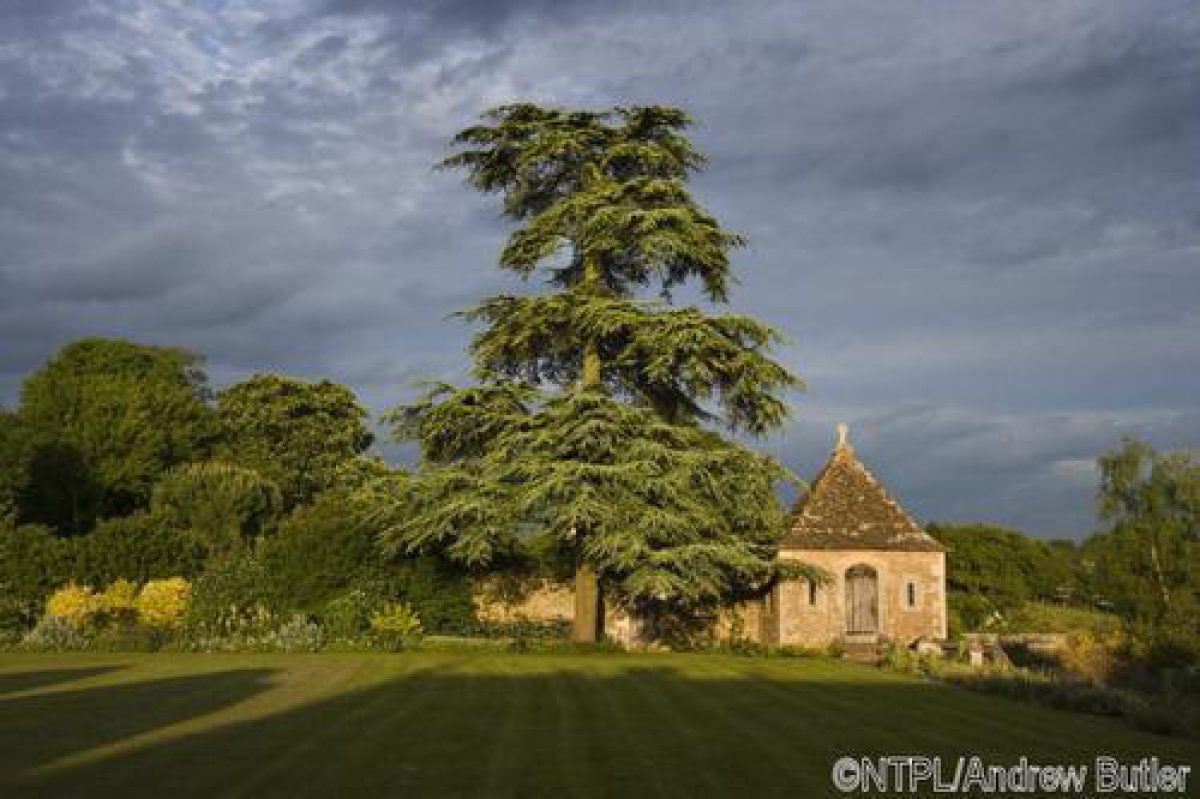
Along the garden wall to the east, with the mill cottages beyond it, is another plant border. At its southern end, beyond a door in the Edwardian garden wall that leads to the mill cottages, is Brakspear's summerhouse, or ornamental apple store, of c 1910 (listed grade II). Built in C15 style to match the Manor, the square-shaped building has two storeys and a stone slate pyramidal roof topped with a ball finial. It is built on a slope with entrances on two levels, one reached by steps. Arched windows on its elevations overlook the garden. The summerhouse remains in use as an apple store, with the lower level in use as a cheese room.
Westwards from the summerhouse run two parallel flagstone paths, an upper terrace and a lower one; situated between them is the Autumn Border. To the south, on a lower level, lies the orchard planted with a variety of apple trees. Some 35m west of the summerhouse, steps lead to the foundations of a bastion, which is surrounded by the Bastion Border. From here the lower path continues in a westerly direction, creating a walk lined by the Summer Border. At the west end of the Summer Border are the Moat Steps, flanked by mature climbing roses. These flights of steps, each c 4m long, run through the orchard in a southerly direction down to a small landing place on the north bank of the south moat.
The paved walk along the Summer Border continues in a westerly direction, passing the Spring Border from which steps on either side lead up to the inner court immediately to the south of the Manor. The inner court, paved with large stone flags, has a circular well in the centre, surrounded by four L-shaped rose beds. To its south, below the Spring Border and the path, are the foundation walls of Tropnell's house, which formerly enclosed the inner court on the south side. The paved walk to the south of the Spring Border continues westwards and leads though a gap in a large yew hedge into an area called the Kitchen Garden, Fruit Garden or Square Garden (National Trust 1991-2). From the south-west corner of the kitchen garden runs a cobbled path called the southern Moat Walk. It lies on a slightly higher level, creating fine views to the gardens and the Manor to the north, which are reflected in the Moat. To the south of the Moat Walk is a strip of woodland with a stream running through it. The Walk ends in the south-east corner of the site where it links up with a path that runs in northerly direction to the summerhouse.
Kitchen Garden
The kitchen garden, situated to the south-west of the Manor, is enclosed to the south and east by a clipped yew hedge c 3m high, to the west by the stables, and to the north by the rear of the west wing of the Manor. It has a formal layout with a square lawn divided into four quarters by gravel paths, with in the centre a group of mature yews clipped in the same shape as those in the garden to the east of the Manor. Along the north and west sides are mixed borders.
REFERENCES
Country Life, 36 (15 August 1914), pp 230-7; (29 August 1914), pp 294-301; 94 (27 August 1943), pp 376-9
Victoria History of the County of Wiltshire VII, (1953), pp 59-62
B Cherry and N Pevsner, The Buildings of England: Wiltshire (2nd edn 1975), pp 257-9
Great Chalfield Plant List, (National Trust 1984)
J Brown, Eminent Gardeners (1990)
Great Chalfield Garden Survey, (National Trust 1991-2)
N Milette, Landscape Painter as Landscape Gardener: The case of Alfred Parsons RA, (PhD thesis, University of York 1997), p 255
Great Chalfield Manor, guidebook, (National Trust 1998)
Maps
T L Walker, A survey of the Manor of Great Chalfield, including various plans and drawings, 1837 (extracts in NT Garden Survey 1991-2)
OS 25" to 1 mile:
1st edition surveyed 1884, published 1886
2nd edition published 1900/01
3rd edition published 1936
Illustrations
J Buckler, Series of watercolours of Great Chalfield, 1823 (reproduced in NT guidebook 1998)
Archival items
The archive at Great Chalfield includes the letters and plans of Robert Fuller, and Alfred Parsons and Captain Partridge dated between 1907 and 1911 (see National Trust 1991-2 for catalogue).
- Visitor Access, Directions & Contacts
Telephone
0844 800 1895Website
http://www.nationaltrust.org.ukAccess contact details
The gardens are open on Tuesdays, Wednesdays, Thursdays and Sundays between April and October. http://www.nationaltrust.org.uk/place-pages/150/pages/opening-times-calendar
Directions
The site is off the B3107 3 miles south-west of Melksham.
Owners
The National Trust
PO Box 39, WA5 7WD
- History
The following is from the Register of Parks and Gardens of Special Historic Interest. For the most up-to-date Register entry, please visit the The National Heritage List for England (NHLE):
www.historicengland.org.uk/listing/the-list
HISTORIC DEVELOPMENT
The medieval Manor of Great Chalfield was bought in the mid-15th century by Thomas Tropnell (about 1405-88), who also owned the Neston estate at Corsham. Tropnell largely rebuilt the Manor between 1465 and 1480, but parts of the Great Hall and the adjacent church of All Saints were kept. In 1550 the Manor came into the Eyre family through the marriage of Tropnell's great-granddaughter with John Eyre; the Eyres made no major alterations to the Manor. The Manor was occupied by a Parliamentary garrison from 1644 to 1646 and from the late 17th century onwards it remained mostly vacant and fell into considerable disrepair. In 1769 the Manor was sold to Robert Neale as an agricultural property, and in 1775 he added the vestry to the church. The Manor remained in the ownership of the Neale family throughout the 19th century. In 1836 they commissioned the architect Thomas Larkin Walker, a pupil of Pugin, to carry out a detailed survey of the Manor, but his restoration proposals of 1837 were never carried out. Instead the house was reduced and the hall adapted as a farmhouse.
In 1878 Mr G P Fuller of Neston Park bought Great Chalfield, and the two estates were thus once again brought under one ownership. Between 1905 and 1912, Fuller's son Robert employed the architect Sir Harold Brakspear, who based his restoration of the Manor on Walker's survey drawings of 1837. In 1906, as part of the improvements to the Manor, Robert Fuller commissioned the landscape architects Parsons and Partridge of Newbury, Berkshire to design a formal garden. Alfred Parsons and his business partner, Captain Partridge also worked at Littlecote House (see description of this site elsewhere) in Wiltshire.
During the garden works at Great Chalfield, Robert Fuller lived at Neston Park, but he moved to Great Chalfield following his marriage in 1911. Although not in residence at the time, Fuller was deeply involved with the design of the garden and often altered Parson's proposals to suit his own taste (National Trust 1991-2). There is a large collection of plans, drawings, and correspondence relating to the garden at Great Chalfield, dated between 1906 and 1911 (National Trust collection). As part of the garden improvements, Sir Harold Brakspear was commissioned to design a lodge, situated at the end of an avenue laid out to the north of the Manor. He also designed a summerhouse for the garden. In 1914, following completion of the restoration work to the Manor and the layout of the new garden, the parish church of All Saints was restored by C H Biddulph-Pinchard. In that same year, H Avray-Tipping visited Robert Fuller at Great Chalfield (National Trust 1991-2), and subsequently published an article on the restoration of the Manor in Country Life (1914).
In 1943 Robert Fuller gave Great Chalfield Manor to the National Trust but he remained in residence until his death in 1955. Since that date his descendants have lived at the Manor, and have further developed and replanted the garden with advice from the National Trust. Between 1985 and 1995 the garden walls, paths, and terraces were repaired, and a plant and tree survey was carried out.
Period
- 20th Century (1901 to 2000)
- Early 20th Century (1901 to 1932)
- Associated People
- Features & Designations
Designations
The National Heritage List for England: Register of Parks and Gardens
- Reference: GD2240
- Grade: II
Features
- Garden Wall
- Pond
- Gazebo
- Well Head
- Manor House (featured building)
- Description: The manor was largely re-built between 1465 and 1480. After a period of neglect it was restored by Harold Brakspear between 1905 and 1912.
- Latest Date:
- Moat
- Description: The north boundary is formed by the upper moat or mill pond.
- Mill Race
- Description: an ancient mill leat that runs along the north-west boundary of the site.
- Fishpond
- Description: Spring-fed medieval fishpond.
- Hedge
- Description: Beech hedge.
- Moat
- Description: The southern or lower moat.
- Tree Clump
- Description: A clump of mature chestnuts to the west of the avenue.
- Boundary Wall
- Description: 13th- or 14th-century wall and bastions (listed grade II) to the north of the Manor.
- Wall
- Description: Garden wall with roll-top coping.
- Gardens
- Manor House
- Key Information
Type
Garden
Purpose
Ornamental
Principal Building
Domestic / Residential
Period
20th Century (1901 to 2000)
Survival
Extant
Hectares
8
Open to the public
Yes
Civil Parish
Atworth
- References
References
- {English Heritage Register of Parks and Gardens of Special Historic Interest}, (Swindon: English Heritage, 2008) [on CD-ROM] Historic England Register of Parks and Gardens of Special Historic Interest
- Pevsner, N. and B. Cherry, {The Buildings of England: Wiltshire} (Harmondsworth: Penguin, 1975), pp. 257-9 The Buildings of England: Wiltshire
- Brown, J., {Eminent Gardeners} ([n.p.]: Viking, 1990) Eminent Gardeners
- Pugh. R.B. and E. Crittall (eds), {Victoria History of the County of Wiltshire} (London: Oxford University Press, Vol. 7, 1953), pp. 59-62 Victoria County History: Wiltshire, Volume 7