Introduction
This is a war memorial park, laid out by Coventry City Council between 1921 and 1935, which commemorates Coventry's soldiers and civilians who lost their lives in both World Wars. Features include a number of avenues of memorial trees, a rock garden and a German Peace Garden dating from 1963.
Terrain
The park lies on the highest part of a ridge of high ground, with the land running down to the railway embankment which forms its south-eastern boundary.www.historicengland.org.uk/listing/the-list
A War Memorial Park, laid out by Coventry City Council between 1921 and 1935, which commemorates Coventry's soldiers and civilians who lost their lives in the First and Second World Wars.
LOCATION, SETTING, LANDFORM, BOUNDARIES, AREA
Coventry War Memorial Park, 120 acres, lies on the main approaches to the city from Warwick, Leamington and Kenilworth. It is situated within the ancient parish of Stivichall, now a mainly residential area about a mile south of Coventry city centre, in the southern part of a ridge of high ground between the valleys of the Sherbourne and the Sowe. The park lies on the highest part of the ridge, with the land running down to the railway embankment which forms its south-eastern boundary. To the south-west the park is bounded by Coat of Arms Bridge Road and to the north and north-west by Kenilworth Road; beyond these boundaries parts of Stivichall Common form the setting of the park. The eastern boundary of the park is formed by Leamington Road.
ENTRANCES AND APPROACHES
The main approach to the park is via Stivichall Grove which forms the far north-eastern corner of the site, where the main entrance gateway to the park (listed Grade II) was erected in 1926. The entrance consists of a set of four gate-piers with decorative wrought-iron gates by Hill and Smith of Birmingham.
Two further entrances are situated along Kenilworth Road to the north of the site, one giving access to the park opposite Earlsdon Avenue, the other - situated further west - leading to the car-park in the north-west corner of the park. The park can also be entered from the south, along Coat of Arms Bridge Road.
PRINCIPAL BUILDING
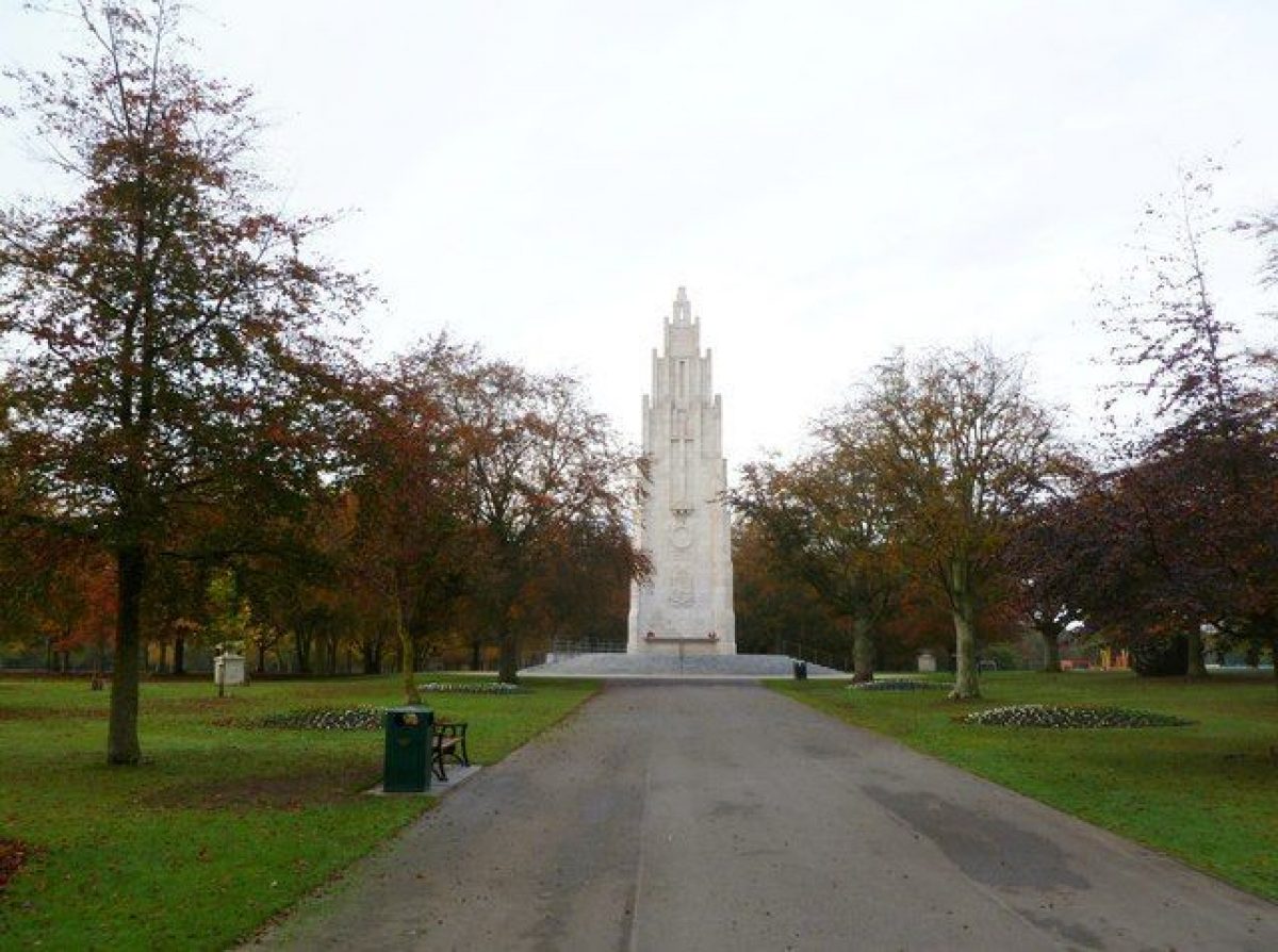
The principal building is the War Memorial tower (listed Grade II*), which stands in the centre of the formal, eastern part of the park. It was built in 1925-7 in an Art Deco style to a design by Thomas Francis Tickner (1864-1924). The tower, over 27m in height and rising to ten tiers, is built of reinforced concrete and clad in Portland stone, and is surrounded by a circular platform in granite, built in 2011, and replacing the former octagonal base. Four Portland stone pedestals, built in 1928 to support flood lights, stand in line with the corners of the memorial tower, one having a cast-iron junction-box behind it to supply electricity for the floodlighting and loudspeakers used on Armistice Sunday.
PARK
The park took 15 years to complete, during which time the designs continued to develop. Since 1935, when the park's buildings were completed, the park has evolved further, with a number of alterations to original features, and the addition of new ones. Nonetheless, the overall plan of the park has remained largely as originally laid out during the first phase of development.
From the first, the park has been divided into an ornamental section and a more informal part incorporating sports fields and facilities. These two sections are divided by a line thought to represent the course of a medieval track, and a number of trees remaining on this boundary survive from the hedgerows which formerly stood in this position.
The ornamental section covers the north-eastern part of the park, and centres on the War Memorial, from which a number of avenues radiate, lined with memorial copper beech trees. The principal avenue leads from the main entrance, to the north-east, beside which is a very simple stone-clad shelter in a Classical style. Paths lead around the periphery of the ornamental section; these too are lined with memorial trees, beech being joined by blue Atlas cedars to the north, and clipped hollies to the south. The majority of the trees in this part of the park, lining the paths and on the lawns, commemorate soldiers lost in the First World War, and are marked by metal plaques on small stone plinths. The area between the Memorial and the main entrance was originally marked by a pattern of curving paths, which is still in evidence to the north-west of the main walkway, but has been reduced to the south-east. Situated by the principal avenue is an Airborne Forces Memorial, formed of a rustic stone monolith with applied slate plaques, and a granite memorial to Arthur Hutt, VC. To the north-west of this main walkway is the rock garden, created in 1926, its naturalistic form reflecting its origin as the site of former cattle ponds; the pool at the centre of this area being now silted up. To the north of this is the 1963 German Peace Garden, donated by the West German Horticultural Federation, its modern design, with paving and raised planters, having been renewed in 2011. In the eastern part of the ornamental section is the formal circular rose garden, with beds in concentric circles, created in 1931; this was subsequently enlarged, but has now been returned to its original dimensions, and was re-planted in 2011, with low box hedges defining the beds. The north-western area of the ornamental section was originally designated for tennis courts and bowling greens. This area has seen considerable re-arrangement: the three bowling greens remain, and there are now ten all-weather tennis courts. The original pavilion - a stone-clad Classical structure, surrounded by a colonnade - stands to the north, and a small shelter similar to that by the main entrance stands to the west. The south-eastern part of this division of the park is now largely grassed over, but also contains the children's play area, a skateboard park, and a red-brick aviary built in 1990. To the south of this division, near the boundary with the playing fields, is a second pool in a rustic setting, the treatment being less elaborate than that of the rock garden to the north; this pool is also now somewhat neglected (2012).
The section containing the playing fields, lying to the south-west, has been in use as a sports area since the opening of the park. The arrangement of football and cricket pitches has changed over time, though the golf course to the south-east of the site has been established since 1930. The playing fields section has the former cricket pavilion near its centre; the single-storey structure with its tiled roof and verandah with timber posts has recently been extended and converted to a visitor and education centre. The building is accessed by a road from the northern entrance opposite Earlsdon Avenue, and by the later road from the car park to the west. Both roads are lined with memorial trees; those to the northern road were planted by 1937, whist those to the eastern road belong to the post-Second World War tree-planting campaign of 1948-52. Near the northern entrance is a small stone-clad shelter in a rustic style, with banded pilasters to the corners, and a tiled roof.
Selected Sources
Unpublished Title Reference - Author: Hodgetts, C - Title: Coventry War Memorial Park Historical Appraisal - Date: 2006
Reasons for Designation
Coventry War Memorial Park is designated at Grade II for the following principal reasons:
Landscape Design Interest: it is a good and representative example of a war memorial park, a relatively rare landscape type, displaying significant attention to landscaping, created after the First World War with additional landscaping dating from after the Second World War;
Historic Interest: especially in the context of Coventry, which suffered such great human loss during both World Wars, the park possesses considerable historic significance for its strong association with these world conflicts and the poignant cost of such involvement;
Intactness: the park has remained mostly intact;
Group Value: the park has strong group value with a number of associated heritage assets including the contemporary War Memorial positioned at its centre (listed Grade II*) and the main entrance gates and piers to the park (listed Grade II), and to which it forms their essential setting.
Date first registered: 08-Jan-2013
- Visitor Access, Directions & Contacts
Access contact details
The park is open 24 hours a day, every day.
Owners
Coventry City Council
Council House reception, Earl Street, Coventry, CV1 5RR
- History
The following is from the Register of Parks and Gardens of Special Historic Interest. For the most up-to-date Register entry, please visit the The National Heritage List for England (NHLE):
www.historicengland.org.uk/listing/the-list
In 1919 Coventry City Council invited members of the local community to form a War Memorial Committee to consider ways of creating a fitting memorial by which to commemorate the city's soldiers who had fallen in the First World War. It was decided that this should take the form of a park, which would also be a welcome and valued new amenity, as the provision for open space in Coventry was limited at that time. The favoured location was Stivichall and in 1919 the land was purchased from the Hon A F Gregory following a public appeal for donations. The plans for the park were partly dictated by existing features and in particular the course of a medieval track, which would divide a formal section from playing fields. The playing fields - which were to form a substantial portion of the park - would be particularly welcome, as Coventry had scant provision for games and physical recreation in 1919. The formal area was to include rock gardens, utilising existing cattle ponds, and in the centre, a War Memorial from which avenues planted with memorial trees would radiate. A children's playground, pavilions, shelters and refreshment rooms would also be provided. However, due to limited funds and urgent priorities elsewhere in Coventry, such as local housing provision, the creation of the park would ultimately take over ten years, and at the formal opening on 9 July 1921, with a dedication and memorial service, only the preparation of the ground had been completed in the ornamental section, though the sports pitches were available for use. Thereafter, work progressed slowly; the layout of the park, with the War Memorial on high ground at its centre, was decided in 1923. Planting began in the spring of 1925 and the planted avenues were opened to the public that summer; a memorial plaque with which to dedicate a tree could be purchased from the Council. In February 1927 the Coventry Herald commented on the copper beeches with which the park's paths were lined, and on the beautiful rock garden, flower beds and shrubs; it was noted that the War Memorial was under construction. The Memorial, built to a design by local architect Thomas Francis Tickner, was inaugurated by Earl Haig on 8 October 1927. A small golf course was laid out on land by the railway in 1930, possibly making use of earthworks associated with a medieval field system. Recent images incorporated in the LIDAR data from the Environment Agency, indicate the presence of ridge and furrow and track ways in this area. In 1933, building work began on a suite of buildings designed by the City Engineer, replacing temporary structures, and the pavilions were first used at the Coventry Carnival in June 1935.
During the Second World War large sections of land in the park were ploughed and used for food cropping and demonstration allotments. Aerial photographs taken in c1946-7 show that most of the mature trees in the playing fields had disappeared by that time, possibly because of intensive sports use, but more likely because of the introduction of anti-aircraft guns in 1941, as well as a row of concrete cubes (probably for the defence of an underground ammunition store in the park), trench shelters, and a roadway allowing military access to the pavilion.
In 1948-52 a memorial tree-planting campaign took place to commemorate local soldiers and civilians who lost their lives in the Second World War, resulting in the planting of another avenue across the north of the golf course to the pavilion, and one near the Beechwood Avenue entrance, where by 1977 a car-park had been created. In the early 1950s children's facilities were developed in the park including play equipment and a paddling pool. In 1963, a German Peace Garden was opened to the north of the rock garden. In 1990 an aviary was introduced in one of the former tennis courts, replacing a collection of wartime huts that had occupied the site.
Memorial tree planting continues to this day (2012) and recently Coventry City Council has refurbished the park, funded by the BIG and Heritage Lottery Funds Parks for People Programme.
The War Memorial Park, Coventry is part of the Fields in Trust historic protection programme and have been protected since July 2014 under the Centenary Fields protection type.
Period
- 20th Century (1901 to 2000)
- Early 20th Century (1901 to 1932)
- Features & Designations
Designations
The National Heritage List for England: Register of Parks and Gardens
- Reference: 1408915
- Grade: II
Features
- Building (featured building)
- Description: The principal building is the War Memorial tower, which stands in the centre of the formal, eastern part of the park. It was built in an Art Deco style to a design by Thomas Francis Tickner (1864-1924). The tower, over 27m in height and rising to ten tiers, is built of reinforced concrete and clad in Portland stone.
- Earliest Date:
- Latest Date:
- Gateway
- Description: The entrance consists of a set of four gate-piers with decorative wrought-iron gates by Hill and Smith of Birmingham.
- Earliest Date:
- Latest Date:
- Earthwork
- Description: The ornamental and informal areas of the park are divided by a line thought to represent the course of a medieval track, and a number of trees remaining on this boundary survive from the hedgerows which formerly stood in this position.
- Avenue
- Description: The principal avenue leads from the main entrance, to the north-east.
- Garden Building
- Description: A very simple stone-clad shelter in a Classical style.
- War Memorial
- Description: Situated by the principal avenue is an Airborne Forces Memorial, formed of a rustic stone monolith with applied slate plaques, and a granite memorial to Arthur Hutt, VC.
- Rockery
- Description: The naturalistic form of the rock garden reflects its origin as the site of former cattle ponds.
- Earliest Date:
- Latest Date:
- Planting
- Description: The German Peace Garden, donated by the West German Horticultural Federation. Its modern design, with paving and raised planters, was renewed in 2011.
- Earliest Date:
- Latest Date:
- Rose Garden
- Description: In the eastern part of the ornamental section is the formal circular rose garden, with beds in concentric circles. This feature was re-planted in 2011.
- Earliest Date:
- Latest Date:
- Bowling Green
- Description: There are three bowling greens.
- Pavilion
- Description: The original pavilion is a stone-clad Classical structure, surrounded by a colonnade.
- Aviary
- Earliest Date:
- Latest Date:
- Pool
- Description: There are two pools, one in the rock gardens and a second near the playing fields. Both are in poor condition.
- Pavilion
- Description: The former cricket pavilion is a single-storey structure with a tiled roof and verandah. It has recently been extended and converted to a visitor and education centre.
- Garden Building
- Description: Near the northern entrance is a small stone-clad shelter in a rustic style, with banded pilasters to the corners, and a tiled roof.
- Avenue
- Description: Several avenues of memorial trees were planted during this period.
- Earliest Date:
- Latest Date:
- Key Information
Type
Park
Purpose
Recreational/sport
Principal Building
Parks, Gardens And Urban Spaces
Period
20th Century (1901 to 2000)
Survival
Extant
Hectares
48.5
Open to the public
Yes