Introduction
Carlton Towers has an associated landscape park with pleasure grounds. Features include wooded walks, a walled garden and much open parkland. The main house on slightly raised ground affords views across the landscape. It is characterised by significant plantations in an area of largely open farmland, which is crossed by many watercourses.
Terrain
Carlton Towers park and garden lie in the flat valley landscape of the River Aire.Location, Area, Boundaries, Landform and Setting
Carlton Towers park and garden is adjacent to the village of Carlton, 5.5 miles south-east of Selby and 5.5 miles west of Goole. The area of the historic parkland, kitchen and pleasure grounds is 153 hectares (379 acres).
The boundaries of the historic parkland are the same as those of the late 19th century when the last expansion of the park was undertaken. To the north, it is bounded by Mill Lane, to the west by the A1041 until the southern entrance, when it moves farther west to the Weigh Bridge Drain to include the western section of the lake. The southern extent is marked by Marsh Lane (off A1041) until the eastern end of the lake, with the boundaries further east marked by the Baffin Hill plantations. The eastern boundary is the ‘New Bank' together with the Kennel and Drain [now ‘Three Pigeon Wood' and ‘Long Wood'] plantations.
Carlton Towers park and garden lie in the flat valley landscape of the River Aire, although the main house is slightly elevated at 8m AOD. The underlying geology is sandstone (Sherwood Sandstone Group) overlain with glacial tills and drift (Lake Humber deposits). The majority of the park is overlain with clays and silts, giving rise to slowly permeable, seasonally wet, loamy and clayey soils. The northern parkland has bands of sand and gravel forming freely draining, acid and sandy. Some areas around the lake are wet, very acid, sandy and loamy soils. Current land use is mainly pasture.
The main house on slightly raised ground affords views across the landscape. It is characterised by significant plantations in an area of largely open farmland, which is crossed by many watercourses from rivers such as the Aire to man-made drainage systems.
The site lies in the Selby District Local Landscape Character Area: River Aire Corridor.
Entrances and Approaches
Southern Entrance: this principal entrance is off the main road into Carlton village, just to the north of the bridge over the lake. The entrance is flanked by two gate piers (Grade II) that date from c1770 and have been attributed to Thomas Atkinson (HE listing) for Thomas Stapleton. The route was altered in the 1840s when the main entrance was moved to the southern aspect from original western aspect.
Northern Entrance: this is a secondary entrance, again off the main road of Carlton village and opposite the Church. It now runs to the north of the area marked ‘Toft' on 18th century and early 19th century maps but in the 1808 enclosure map, there is a road labelled ‘Stocks Lane' to the south of the Toft area. It then continues to the east of the walled garden and onto the stable area.
Principal Building
Carlton Towers [Grade I] was started in 1614, probably to a design by John Smythson (Girouard 1967a, 178). To the north of the Jacobean house was added a wing before 1765. About 1777 a large range was built to the east by Thomas Atkinson that had a chapel and stables (Girouard 1967a, 179). This was remodelled in 1844-5 and again in 1873-5 in the Gothic style by Edward Welby Pugin as part of a much grander scheme. The design was only partially completed when Pugin died and no further external work was undertaken. The interior was completed between 1875 and 1890 by J F Bentley for Lord Beaumont.
The ‘Pumping House or Shed' [Grade II] is a folly c1770 by Thomas Atkinson for Nicholas Stapleton, this is probably the building referred to in 1773 as ‘water house' (29/15). The Ice house was built before 1772, the remains of the circular ice house measure 4.30 m in diameter, formed by a brick wall at ground level 800 mm thick with what appear to be buttresses on the north and south.
Gardens and Pleasure Grounds
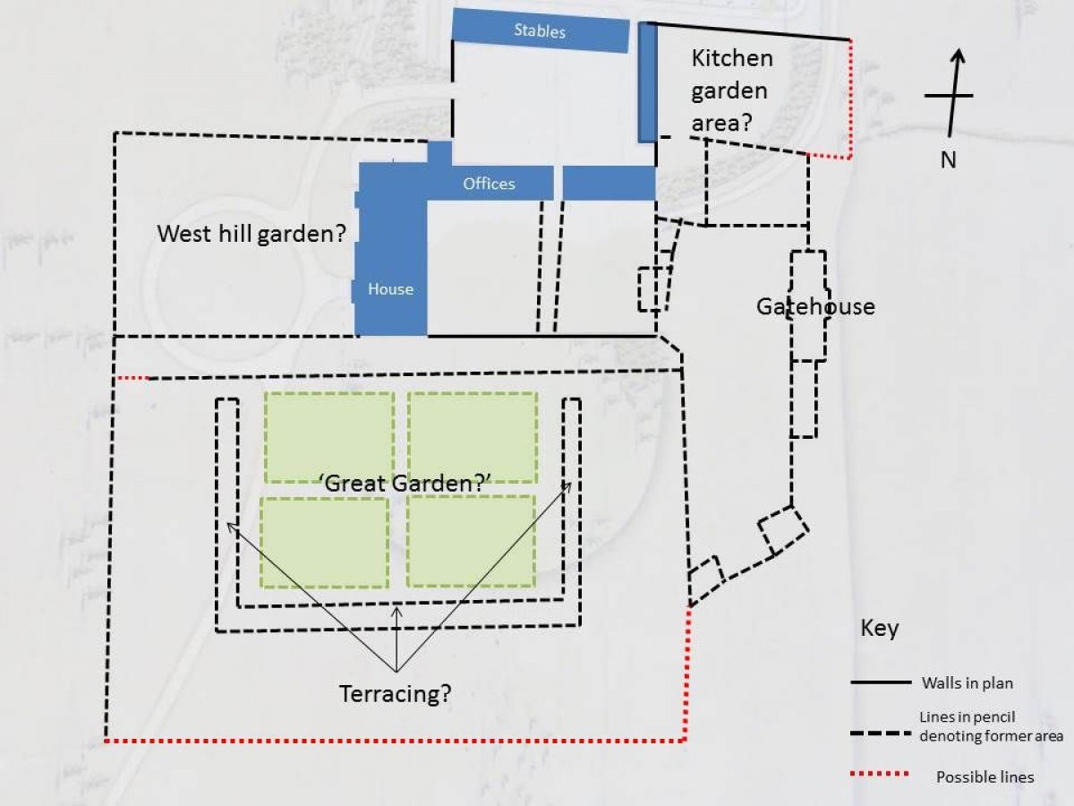
The area around the house has had a series of ornamental gardens dating from the construction of the house in the early 17th century. The west front was the original main entrance and it is likely that the knot garden referred to in 1659 was on this side of the house, as the best views would have been from there. The ‘four square' garden with the raised walkway was constructed to the south of the house in 1672 and sometime before 1698, the ‘west hill garden' was put in to possibly replace the now old-fashioned knot garden.
These early gardens remained until the landscaping undertaken in the 1760s and 1770s when the formal gardens were removed to allow the parkland to come right to the house. In the 1840s with the change in garden fashion, more formal elements were reinstated to the south and east with the new courtyard and entrance. To the north, shrubberies were added alongside the tree planting of the previous century. The final changes were undertaken in the 1870s and 1880s when the parterre and ‘Italian' garden were added.
Kitchen Garden
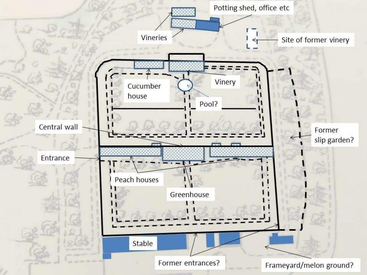
Prior to late 18C, the first kitchen garden was probably in the walled area to the east of the stable block (see Figure 1). Within this area (and near to the stables to provide the dung for heat) were a series of glass-covered frames for melons and cucumbers as recorded on 1st April 1702 at a cost of £2 11s 8d (2/48/16).
Cowell's (2005, 219) analysis and household accounts supports the view that the walled kitchen garden was constructed according to Woods' 1765 plan. White's later plan shows the walled garden as identical to Woods'. Woods' original plan shows a square walled garden with rounded corners on the north end. There is a central wall running east-west within the garden, with paths around 4 quadrant beds and the central wall. The internal wall was perhaps was intended as a hot wall. It was certainly used for supporting greenhouses later, as the 1893 sale plan and photographs (Snaith History Society, 69-70) show.
Woods' plan shows three entrances to the walled garden: one in the mid-south wall, near the stables (still extant); one in the south-east corner (now gone), with a path around the outside to a (main?) entrance in the middle of the west wall (now gone). There is also a semi-circular area of beds shown north of the walled garden. The current walled garden is 272 ft x 272 ft, occupying 1.70 acres. There is no reason to believe that the size has changed since originally constructed. The sale plan of 1893 shows the walled garden as very similar to that in the Woods' plan, with the addition of glasshouses along the south side of the internal wall and to the north of the walled garden.
The construction of the walled garden coincided with the building of at least two greenhouses/hot houses before 1771. The one shown outside the new kitchen garden may be the ‘greenhouse' and the one inside the walled garden is more likely to be a ‘hot house'. A second [smaller] building, referred to in 1773 as a ‘new hot house' was added outside to the east of the first and is shown on the 1808 map. These two buildings would seem to be the ‘vineries' described in bills. The reference to a ‘peach-house' in 1813 (29/29) is probably in the structure inside the walled garden.
Work by glaziers and a hailstone insurance policy in 1844 (2/11/44) may indicate that the existing structures were updated to include glass roofs and possibly extended. The structures listed were a large hothouse, a succession house and a peach house and to the north of the walled garden, two vineries. In the melon ground, there was a Calcutta pit and portable lights [cold frames]. Further glasshouses were added after 1849 along the middle internal wall, as well as another on the northern wall. The vineries outside may have been rebuilt as the one to the east has disappeared and replaced by one to the north.
The sale plan of 1893 (ERA DDCL3299) gives the following. Within the walled garden, along the south side of the internal wall, were two peach houses 103 ft long by 10' 9" wide, a greenhouse and storehouse 62 ft long, all heated by hot water pipes. These occupied the width of the garden (c.270'), with the greenhouse in the middle. Along the north wall was a vinery 59 ft long by 16' 6" wide and a cucumber house 41 ft long. Two vineries of each 66 foot long by 16' 6" wide, heated by hot water pipes, were to the north of the walled garden, along with potting sheds, office and tool house (Figure 2).
Park
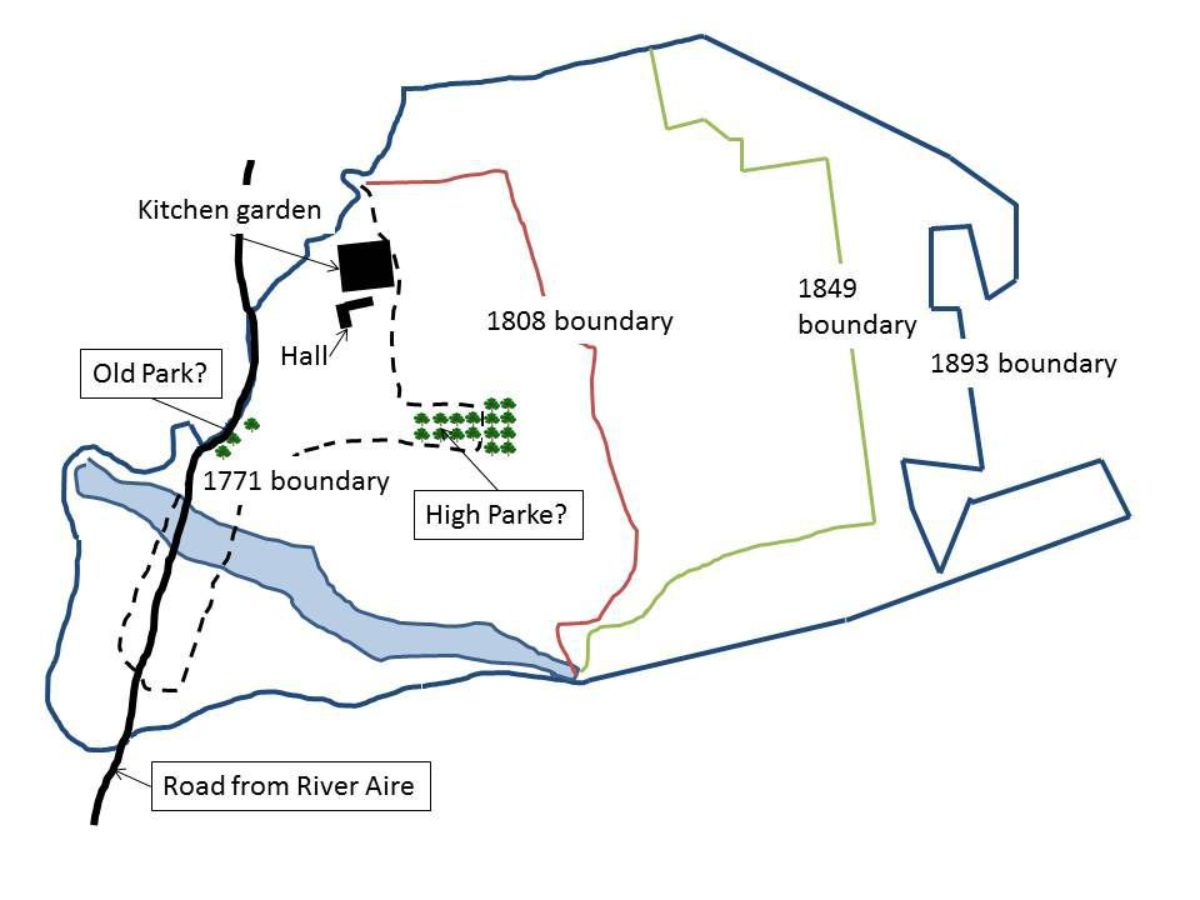
The survey of c1600 mentions a ‘High Parke', which was still there in 1753 when the valuation of timber was undertaken (36/8). The map of the same date shows a t-avenue of trees to south-east of house (see Figure 3), so this perhaps is the High Parke. There is also an avenue shown to the east of the main road into Carlton village, so this could be the site of the ‘Old Park' referred to in the field survey of 1725.
By 1771, these areas had been opened up to form a larger parkland area, implementing the start of the landscaping plan by Woods. The survey of 1789 says that Carlton Park has 102 acres (4/36/12) [again in 1793] and this would appear to cover the area marked on the Enclosure map of 1808 as ‘Hall Garth' (NYRCO WRRD B 26 [MIC 601]). This also replicates the area shown on White's plan as parkland with a shelterbelt to the north and east and planting around the new lake. In the 1839 survey, the ‘Woods, Plantations & Ponds' came to 152 acres, 3 roods and 10 perches (36/31), as the area to the south of the western end of the lake had been included. The park was extended eastwards in the 1840s and again in the 1870s. By the time the estate had come up for sale in the 1893, the park was 279 acres (ERA DDCL3299). The current size of the park is about 300 acres. The changes in the extent of the parkland can be seen in Figure 3.
- Butt Hole Plantation is to the north of the house and kitchen garden. The name ‘Butt Hole' first appears on the 1771 map and would appear to be part of the landscaping as suggested by Woods' plan. There is a significant depression in the area and would suggest that this was made as an artificial pond to provide ice for the newly built ice house nearby.
- Green Gates Plantation is to the north-east of the house and kitchen garden, extant by 1893 and probably created in the 1870s. Name dates from the early 17th century as listed on the survey of the time.
- Sand Hole Plantation is South of Mill Lane and probably created in the 1870s.
- Kennel Plantation is south of Mill Lane, east of Sand Hole and created in the 1870s.
- Drain Plantation is to the eastern boundary of the park extant by 1893 and probably created in the 1870s.
- Baffin Hill Plantation is by the southern boundary of park extant by 1893 and probably created in the 1870s.
- Ell Pond Plantation adjoins the eastern end of Fishpond extant by 1893 and probably created in the 1870s.
- The Rookery & Wilderness surround the western end of Fishpond and created in the 1780s, following White's plan.
- Half Moon Wood is in the centre of the park extant by 1893 and probably created in the 1870s and Duck Pond Wood is in the in centre of the park surrounding duck pond, extant by 1950
Detailed description contributed by Yorkshire Gardens Trust 07/06/2016
- Visitor Access, Directions & Contacts
- History
Estate owners
13th - 14th Century
The estate has been owned by the Stapleton family since the late 13th century. In 1394, Carlton passed to Brian Stapleton (c.1385-1418) who was the first of the family to live there.
17th - 18th Century
The current Hall dates from 1614 and was built by Elizabeth Stapleton (Robinson 1979, 116). Sir Miles Stapleton succeeded to the estate in 1656 and was an enthusiastic manager of his estate for over sixty years, judging from his Household Account Books. When Sir Miles died, the estate passed to his nephew, Nicholas Errington. When he died, it was his son, also Nicholas, who inherited in 1716, having taken the name of Stapleton. Thomas Stapleton was a minor when his father died in 1750 and Carlton was managed by his mother until he reached his majority.
Thomas' long tenure (over seventy years) largely shaped the landscape that we see today. Between 1765 and about 1784, he created the landscape park, lake and walled kitchen garden, employing the designers Richard Woods and Thomas White. The parkland around the hall was further expanded by Miles Thomas Stapleton in the 1840s.
The final development in the 1870s was by Miles Thomas' son, Henry. He rebuilt the Hall but he was forced to sell off a large part of the estate in 1888. By this time, the park increased to its present proportions and a new formal garden was put in next to the house. Henry was succeeded by his brother, Miles, in 1892. Miles died three years later, leaving his estate to his elder daughter, Mona. She married Lord Howard of Glossop and continued to live at Carlton until she died in 1971. It passed then to her son, Miles, who later became the Duke of Norfolk. The present occupant is Miles' son, Lord Gerald Fitzalan-Howard.
Key owners who made changes to the designed landscape are:
- Elizabeth Stapleton, b1568 (1612-1648)
- Sir Miles Stapleton, b1626 (1656-1707)
- Thomas Stapleton, bc1739 (1750-1821)
- Miles Thomas Stapleton [8th Lord Beaumont], b1805 (1839-1854)
- Henry Stapleton [9th Lord Beaumont], b1848 (1854-1892)
Early history of the site
Note all references are from HHC UDDCA unless otherwise stated
In 1272, the sister of Peter de Brus III, Laderine, inherited Carlton from her brother. It was through her daughter with John de Bellew [or Bella Aqua], Sybil, who married Sir Miles Stapleton, that Carlton came to the Stapleton family. The site of the Medieval house, probably started by Brian de Stapleton after 1394, is unknown but Girouard (1967, 177) speculates that it is on the site of the present house.
No deer parks for Carlton appear on the maps of Yorkshire by John Speed (published 1611/2). So the ‘old park' referred to in 1659 was probably a post-medieval pleasure ground. In a field survey of 1725 (2/11/17), its dimensions were noted as 10.4x6.75x9.75x13.1 chains (c8¾ acres).
Work on the new Hall started in 1614 and there is a list of ‘Carlton's new gardens and outhouse? &c' (36/3) dated by the archives to c1600:
- The Orchard -1 acre, 1 rood, 2 perches
- High Parke -17 acres, 3 roods
- The Inges - 37 acres
- Greene Gates - 31 acres
- Low Rookehill - 15 acres, 1 rood, 5 perches
- High Rookehill - 20 acres, 2 roods
- House close - 7 acres, 2 roods
- Long close - 7 acres
- Baughame - 27 acres
- The close about the house - 16 acres
Whilst there is some building work done on the main house in the 2nd half of the 17th century, including a new kitchen and chapel, the overall layout of house, outbuildings and surroundings by 1656 was probably the same as that depicted on the survey map of 1753 and the tracings visible on both Woods and White maps (Figure 1).
Chronological history of the designed landscape
1656-1764
On finally moving to Carlton Hall in 1656, Sir Miles actively reshaped the gardens he inherited. The initial entries from 1659 are ones of maintenance, however the following year, he started to change the gardens as he ‘Paid to Ned: & Cowlam & Wards wench? for grounding [preparation or laying of a ground] in the court before the hall doore one day & a halfe - 2s'.
A major change came in 1672 when he employed Thomas Newbould ‘of Derbyshire' to design and implement a new garden, described as:
Disbursed for grounding, digging & levelling the great Garden at Carlton House & for laying the green swarth in the four quarters, or grass plats & for levelling & laying the Walkes in the garden & the high terras [terraces] walkes, round about the great garden (2/48/5).
On the 1st of April 1673, the work is completed as he notes:
Mem: Disbursed in wages to the gardener and other labourers for diging grounding levelling & laying the great garden with laying the grass plats & high & low walks according to the particulars (?) set down on this & the other side of this lease (?), besides severall of my own servants grounding & weeding & my own waggon for fetching the swarth sods from the Moors disbursed - £21 7s 8d (2/48/5).
Figure 1 shows the possible site of this ‘Great Garden'. He also fenced off parts of the parkland at this time.
In 1689, he records garden seeds being bought from a Mr Anthony (or Apothecary?) Johnson of Pontefract (2/48/10). In 1698, there is another reference of garden seeds being bought from Pontefract (2/48/12) and he refers to work in another part of the garden (2/48/13): ‘Paid to John Walker [the gardener] for diging, dressing & fallowing [ploughing without seeding?] the west hill garden July the 17th 1698 - 18s'. This possible area is marked on Figure 1 [and was formerly the site of the knot garden?].
Following Sir Miles' death, the estate passed to his nephew, Nicholas Errington. Both he and his son, who succeeded him in 1716, lived at Carlton. However neither seems to have done much to alter either house or garden in this period. The only exception is the sale of some timber on 10 May 1742 (4/147).
1765-1838
In 1765, Thomas Stapleton commissioned a plan to improve the estate from Richard Woods. There is also an undated plan from Thomas White Senior. With the two maps available that pre- (ERA DDCL/3390)and post-date (36/34) the plan by Woods and information from the archives, it is now possible to confirm the White plan was prepared before September 1773.
The first significant change is the new walled kitchen garden with its associated buildings (marked in red on 36/34) and the removal of the courtyard around the house, although from this it is difficult to see whether Woods' landscaping ideas around the house and garden have been implemented. Further evidence can be found in the entries for 1765/6 in the Garden Accounts where it states ‘Labourers' wages to Mr Peach [total] - £203 4s 2d' (29/13). A Thomas Peach worked with Richard Woods at Cannon Hall in Yorkshire as a foreman and left there in 1763 (Cowell 2005, 232).
Pineapple plants were purchased in 1767, which together with regular purchases of bark indicated that a pineapple pit was in operation. A hothouse had also been installed by this date. The plan of c1771 seems to indicate that there are two buildings: one on the north wall inside the walled area and another, again on the northern side, outside the walled area.
In 1772 there is a reference ‘for ice house filling' on the 23rd January (29/13). The ice house does not appear on either Woods' or White's plan, however the location of the ice house can be seen marked on the 1st edition Ordnance Survey map of 1849. The other feature on the White (marked) and, possibly Woods (unmarked), plans is a Menagerie. No further reference has been found for this.
In 1769, £3 8s 4d was spent on trees (29/13), perhaps indicating the development of the plantations around the walled garden. In the general estate accounts, there are references to ‘water works' in 1773 and there are a number of entries between 2 Jan 1774 and 11 Aug 1775 for payments to Henry Tomlinson for ‘water works', totalling £98. On 14 June 14 1783, it was recorded that: ‘Paid Mr Clark [the head gardener] his 1st quarter payment for Plantations', £25. These payments continued until 31 July 1784. So both these would indicate that White's plan was being implemented from late 1773 until the end of 1784. There are two payments recorded to White ‘on Stapleton' of £300 in March 1780 and £200 in July 1781 (Turnbull 1990, 134).
1839 - 1870
With the accession of Miles Thomas Stapleton in 1839, the estate underwent a further transformation with the park expanding eastwards and the kitchen garden updated with new stock and alterations to the glasshouses. Comparing the 1808 Enclosure map and the 1st edition 6" Ordnance Survey (1849), while there had been little planting in the main park, there was more around the house and kitchen garden.
Miles Thomas made some alterations to the house, starting the Gothic style that was continued by his son. He also enclosed the southern portion of the house and erected a terrace wall and gates in 1846/7 (2/48/110b). On the OS map, there is also what appears to be a planted area within the newly enclosed portion.
1871-1874
Together with his ambitious plans for the house, Henry Stapleton also redesigned the park to a plan from Charles Craigie-Halkett-Inglis in 1871 (2/48/94b). The plan involved cutting down old trees in park, planting new trees and shrubs and erecting the extant iron fencing in 1871, with further tree planting the following year. In 1873, there is a reference to obtaining ‘trees for park extension' with further tree planting in the ‘new park' the next year (2/48/94b).
Later history
The sale plan of 1893 (ERA DDCL3299) lists the following:
The Gardens and Pleasure Grounds
Skirting the Mansion on two sides, are well matured and laid out with great taste. On the South Front is a wide Terrace Walk, communication by stone steps with the Beautiful
Italian Garden
Laid out with gravel paths. There are also Flower Borders, Parterres, and Velvety Lawns, studded with Noble Forest Trees. Extensive
Shrubberies and Wooded Walks
Planted with fine specimens of Forest, Coniferae and other trees, with beautifully kept gravel walks extending the whole length of the grounds
The Park
Is of a charming and diversified character, studded with fine old oak, elm and other timber trees, and clumps belts of young plantations, and skirted on the south side by an
Ornamental Lake
Well stocked with fish, with Boat House and Pumping Shed. On the west side of the Main road is another lake or fish pond, on the banks of which is
The Rookery and Wilderness
With a beautifully shaded walk, skirting for a considerable distance the boundaries of the property
The estate continued to be maintained throughout the 20th century with additional tree planting in the park in the second half. The glasshouses in the kitchen garden fell into disrepair and were removed in the 1970s and the interior is now empty.
Detailed history contributed by Yorkshire Gardens Trust 07/06/2016
Period
- 18th Century (1701 to 1800)
- Late 18th Century (1767 to 1800)
- Associated People
- Features & Designations
Features
- Lake
- Folly
- House (featured building)
- Description: The house was started in 1614, probably to a design by John Smythson (Girouard 1967a, 178). To the north of the Jacobean house was added a wing before 1765. About 1777 a large range was built to the east by Thomas Atkinson that had a chapel and stables (Girouard 1967a, 179). This was remodelled in 1844-5 and again in 1873-5 in the Gothic style by Edward Welby Pugin.
- Earliest Date:
- Garden Building
- Description: Pumping House or Shed.
- Earliest Date:
- Latest Date:
- Icehouse
- Latest Date:
- Kitchen Garden
- Description: The current walled garden is 272ft x 272ft, occupying 1.70 acres. There is no reason to believe that the size has changed since originally constructed. The sale plan of 1893 shows the walled garden as very similar to that in the Woods’ plan, with the addition of glasshouses along the south side of the internal wall and to the north of the walled garden.
- Plantation
- Description: There are numerous plantations around the house and gardens.
- Key Information
Type
Park
Purpose
Ornamental
Period
18th Century (1701 to 1800)
Survival
Part: standing remains
Hectares
153
Open to the public
Yes
Civil Parish
Carlton
- References
References
- Louise Wickham and Mary Ratcliffe {Carlton Towers park and garden} (Yorkshire Gardens Trust, 2016) Carlton Towers park and garden
- PhD thesis, University of East Anglia. Richard Woods 1715/16: surveyor, improver and master of the pleasure garden
- Cowell, F. 1986 ‘Richard Woods (?1716-93): A Preliminary Account: Part I. 'Woods Surveyer at Chertsey in Surry' and at London Stile', Garden History 14, 2: 85-119. Garden History 14
- Cowell, F. 1987a ‘Richard Woods (?1716-93): A Preliminary Account. Part II 'Mr Wood of Essex', Garden History 15, 1: 19-54. Journal of Garden History 15
- Cowell, F. 1987b. ‘Richard Woods (?1716-1793): Preliminary Account. Part III. Influences, Style and Working Methods', Garden History 15, 2: 115-135. Journal of Garden History 15
- Girouard, M. 1967. ‘Carlton Towers, Yorkshire - I', Country Life January 26, 176-180. Country Life
- Georgian Gardens, The Reign of Nature
- Architectural History 22
- Thomas White (1739-1811): Eighteenth Century Landscape Designer and Arboriculturist