Introduction
This is a landscape park with pleasure grounds and woodland that are associated with Escrick Hall. Features include an Ionic temple, woodland walks and a menagerie.
Terrain
The underlying bedrock is Sherwood Sandstone Group, overlain by glacial tills and drift deposits, which give rise to varied soils.Location, Area, Boundaries, Landform and Setting
Escrick Park lies next to the village of Escrick, 8.5 km south of York; the historic parkland was 450 acres (182 hectares).
The western boundary is the present A19 to SE 625 415, then to SE 630 416, south to SE 632 411 and Holly Carrs Wood to the former Riccall Lodges. The southern boundary follows the avenue leading to Approach Farm north, then runs along the bottom of Holly Carrs Wood, next to Dam Dike and then west along Mill Hill and Skipwith Lane as far as SE 633 428. The northern extent is along Main Street at SE 631 423 and to New Bridge.
Escrick Park Hall lies at 15 m AOD, slightly higher than the surrounding parkland at 8 to 12 m OD. The underlying bedrock is Sherwood Sandstone Group, overlain by glacial tills and drift deposits, which give rise to varied soils. Around the Hall the soil is sandy and gravelly. The northern area of the estate, including the pleasure grounds and former kitchen garden, lie on the Escrick Moraine with naturally wet, very acid sandy and loamy soils with low fertility. South of the house, the parkland is on Thorganby Clay, with slightly acid clayey and loamy soils, with impeded drainage and moderate to high fertility. The southern parkland and shelterbelts are on Skipwith Sand with naturally wet, very acid sandy soil.
The main residence is on slightly elevated ground (Escrick Moraine) in a largely flat landscape. The estate is split between the Selby District Local Landscape Character Areas: The York Fringe (north) and Skipwith Lowlands (south), both are Type: flat wooded farmland. Escrick Conservation area includes the Hall, stable block, pleasure grounds and the section of the parkland north of the line between West Lodge and Wheldrake Lodge. An archaeological and historical survey provides a record of features and buildings within the wider estate landscape (MAP Archaeological Consultancy 1998).
Entrances and Approaches
The northern approach has two sets of piers and gates, first 20 m north of house, early-18th century with 19th century additions (Grade II) and second 45 m north, 1907 (Grade II)
There seven lodges as follows:
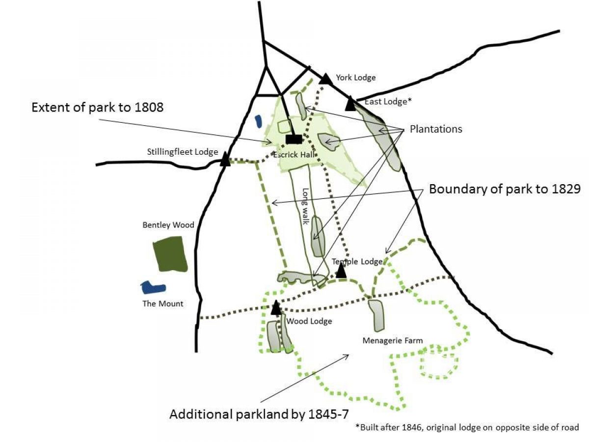
- West Lodge [also Stillingfleet Lodge] is thought that this is the Escrick Park Lodge that was built in 1829. Now listed on modern maps as ‘Rutland House'.
- East Lodge [Grade II]was built after 1846, it is the entrance from the Skipwith Road. It is thought to incorporate medieval fragments (possibly from the old church), the gates, piers and railings next to it are listed Grade II. Now called ‘Wheldrake Lodge' on modern maps, as building across the road is named ‘East Lodge'.
- Temple Lodge [originally Denison's Lodge] was built in 1823 and shown on the Bryant map of 1829, it is still extant.
- York Lodge was built in 1825 on the Skipwith Road. It had been demolished by 1892, possibly after the construction of the East Lodge.
- Cattley's Lodge [also known as Bridger's Lodge and Wood Lodge] was built in 1824 at northern edge of Hollicarrs Wood in Isaac Rush Wood and still extant. Modern maps now call it ‘Catley's Lodge'.
- Riccall Lodges were built in 1829; these twin buildings were off the main Selby-York road and marked the 2.5 mile route through Nart Nooking & the park north to the Hall. They are now gone, having survived into the late-20th century.
The Approach was created 1829-31; this is the southern entrance with avenue leading from the Riccall Lodges to Approach Farm. The gate piers still remain. They are thought to be mid-18th century (Grade II), possibly from an earlier entrance.
Principal Building(s)
-
Escrick Park [Grade II*]
The original late-16th/early-17th century house was pulled down and replaced with the current house around 1680-90. It was altered in 1758 and 1763-1765 (the latter changes by John Carr) to enlarge the main block by deepening it to five bays (from three) and to three storeys (from two and a half). Further additions were made in the mid-19th century to give its present proportions.
-
Escrick Coach House and Stables [Grade II*]
Planned in 1763 by John Carr and completed around 1774. It was linked with the main house in the 19th century and also enlarged to the north.
Other buildings include Ionic Temple [Grade II] dating from around 1812, 150 m south of house, a Garden House [Grade II] built in 1823 for the then gardener, John Reynolds, 40 m south-west of house. There are also two icehouses; the first one, with an east-facing entrance, was built in around 1764 but current evidence shows that it was rebuilt (refaced) in the 19th century. The second was constructed next to it with a south-facing entrance. No exact date has been found for the latter's construction in the archives but it is later than 1847, as it does not appear on the 1st edition 6" OS map.
Gardens and Pleasure Grounds
The mid-17th century map shows gardens to the north of the original hall, as depicted by a series of trees, which may be an orchard (see images). A century later, there was a ‘Flower Garden' to the south of the Hall (see images), depicted in the 1720s sketch as a walled area with a garden building in one corner. As the village buildings were slowly removed from around the Hall, the pleasure grounds started to develop, first towards the east, then to the south and west.
Jane Loudon in 1841 gives the following description in The Ladies' Magazine of Gardening (p361):
September 27.-York.-... we went out to Escrike [Escrick] Park, the seat of Lord Wenlock. Here we found flower-garden very neatly kept; and some rockwork, among which was part of the screen of York Minster, which was removed at the time of the fire. On the terrace in front of the Conservatory, were pots filled alternately with Lobelia fulgens, and Campanula pyramidalis, of the same height, and trained exactly in the same way. The effect was very good, as was also mixture of Tropreolum peregrinum, and Loasa aurantiaca, trained over the rockwork.
These plants were probably grown by Richard Bainbridge, who is described as the ‘flower gardener to Lord Wenlock', in his book Guide to the Conservatory, published in 1842.
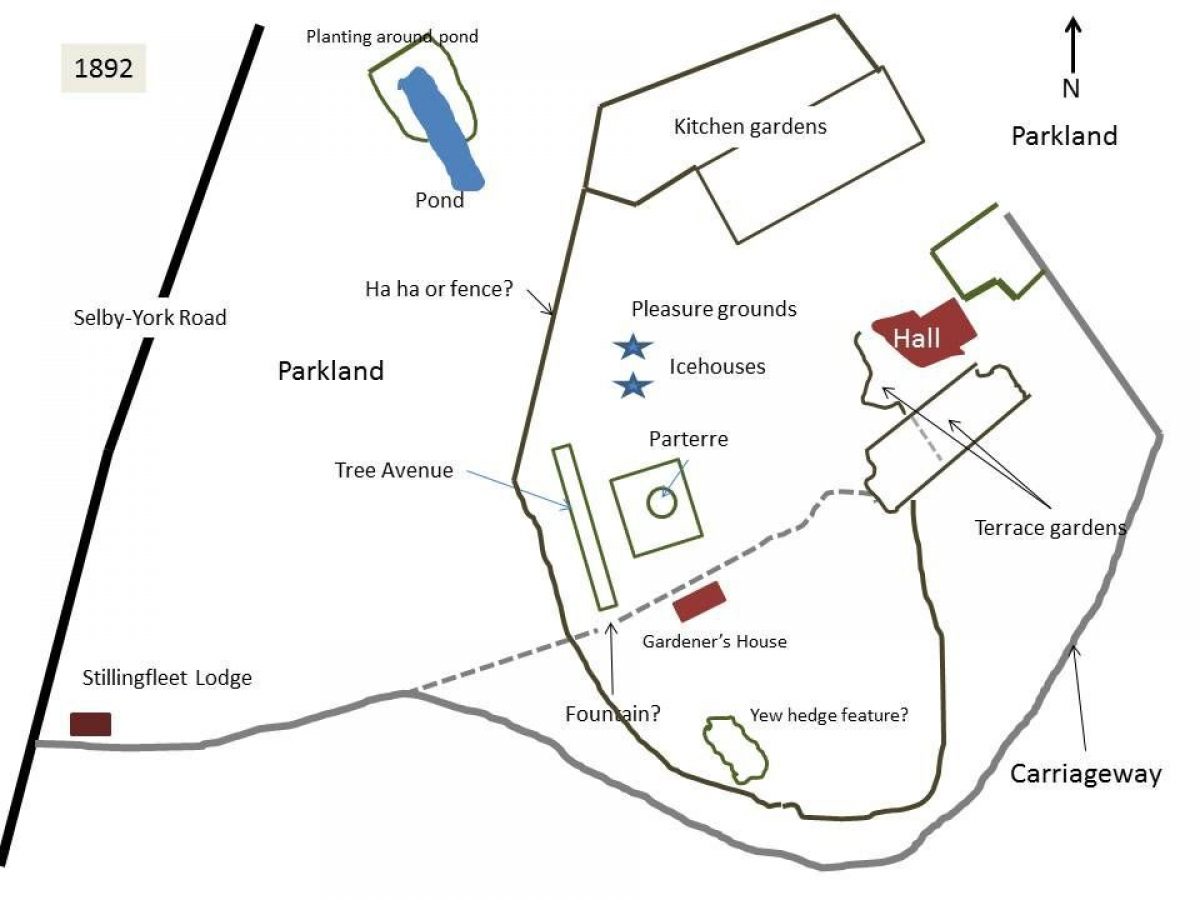
Further additions were made to the pleasure grounds (see images), on the west side:
- A square parterre south of the icehouses
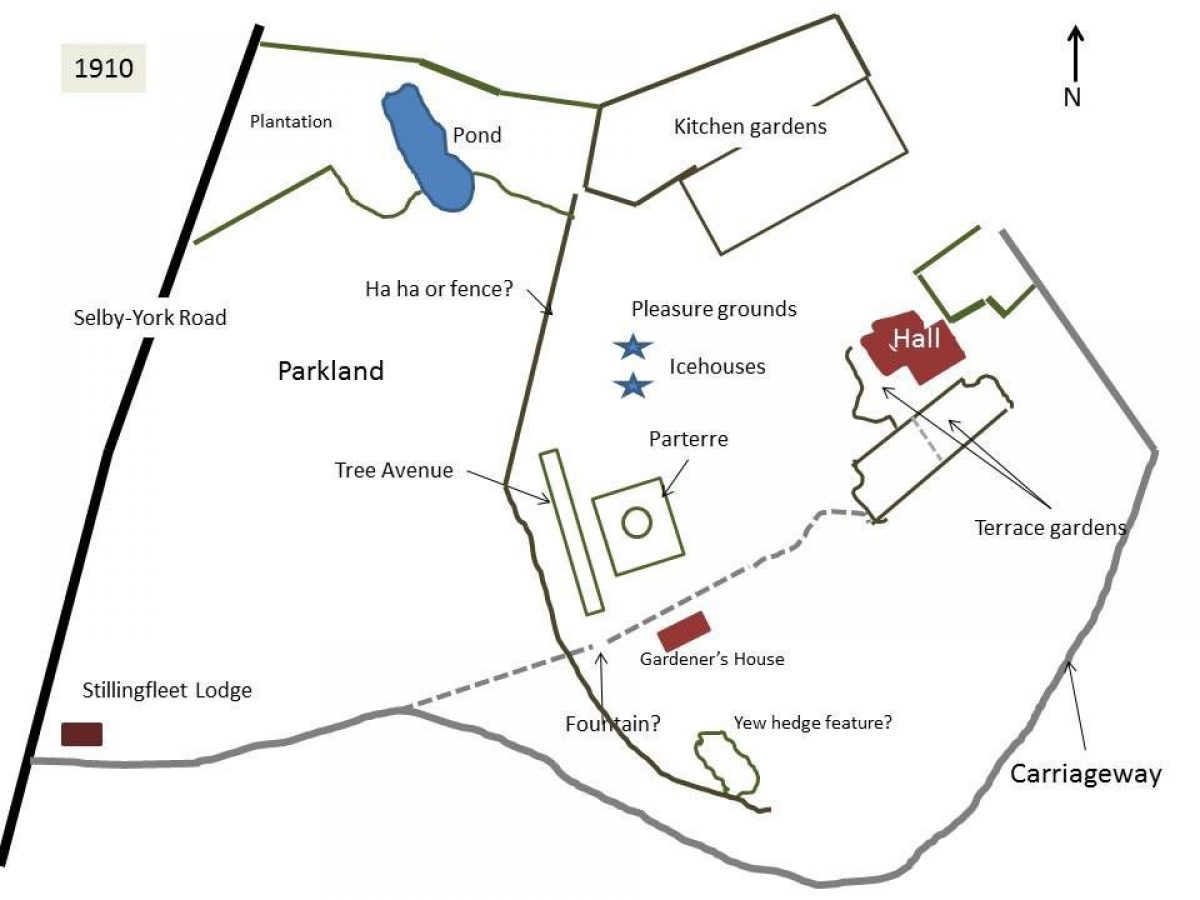
- West of the Gardener's House is an avenue of yew trees going north towards a stone pergola. This is shown in photos of the garden taken around 1900 (3/9/72) and first appears on the 1910 OS map. Its position is now occupied by a wooden structure.
- A small formal garden south of Gardener's House with clipped yew hedges
- Some planting around formal pond to north-west of house (later irregularised with increased planting by 1908)
On the eastern side, there was a lawned area in front of stables with a tree in middle.
Kitchen Garden
The kitchen garden to the north of the Hall was first marked on the 1754 map (see images) but may well date from earlier than that. By 1758, it had a large stove:
‘I think I told you of the plaintain [banana] tree being in fruit at Esquire Thompson & in excellent order but then he has a fine stove [hothouse] 25 feet high all crown glass in front and slope that in summer it draws with an equality of the hottest climate in East or West Indies so that his pines [pineapples] are beyond anybody else' (Letter from Thomas Knowlton to William Stonehouse, Henery 1986, 245)
As well as fruit, it was noted in November 1758 that ‘Esquire Thompson's gardener raised one plant [of Hernandia sonora] this summer' (Letter from Thomas Knowlton to Richard Richardson, Henery 1986, 249).
Prized hot house fruit such as pineapples, bananas and cucumbers were sent down to London when Beilby Thompson was residing there. Beilby Thompson's farm diary (1779-92) also records other fruit, for example on the 16 November 1784, he notes: ‘Fruit Trees got from Tilford [Telford] planted on the New Wall against Harpers Yard'.
He also records in his diary for 1791: ‘25 young peaches & nectarines against the stackyard wall for training'. By 1799, he was also growing grapes, when on the 7 February, Thomas Carr and Thomas Shelby assisted to put vines into the stoves (5/11/2).
On the 13 October 1826, James Taylor was paid £31 for a steaming apparatus & attending the firing and warming of a hothouse (5/11/2). Tregold (1824) shows his system in his book.
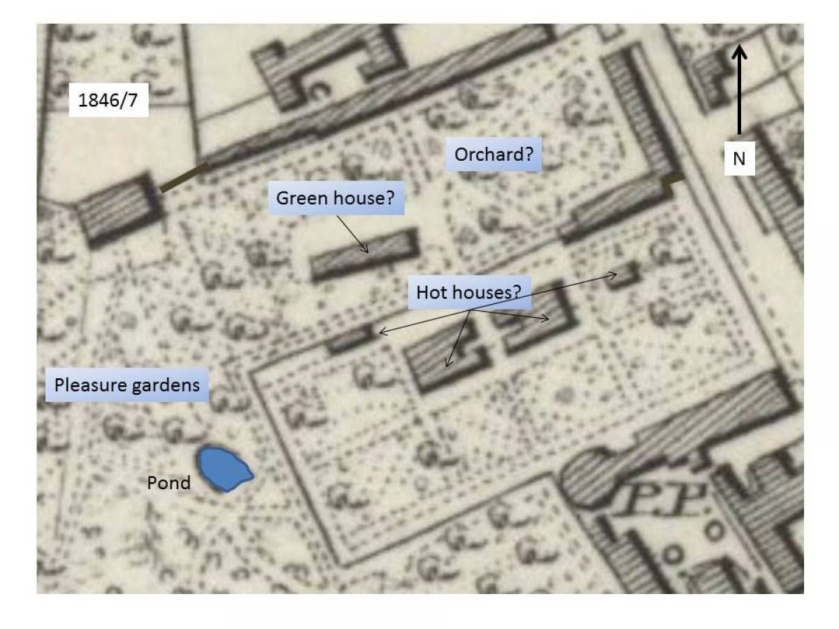
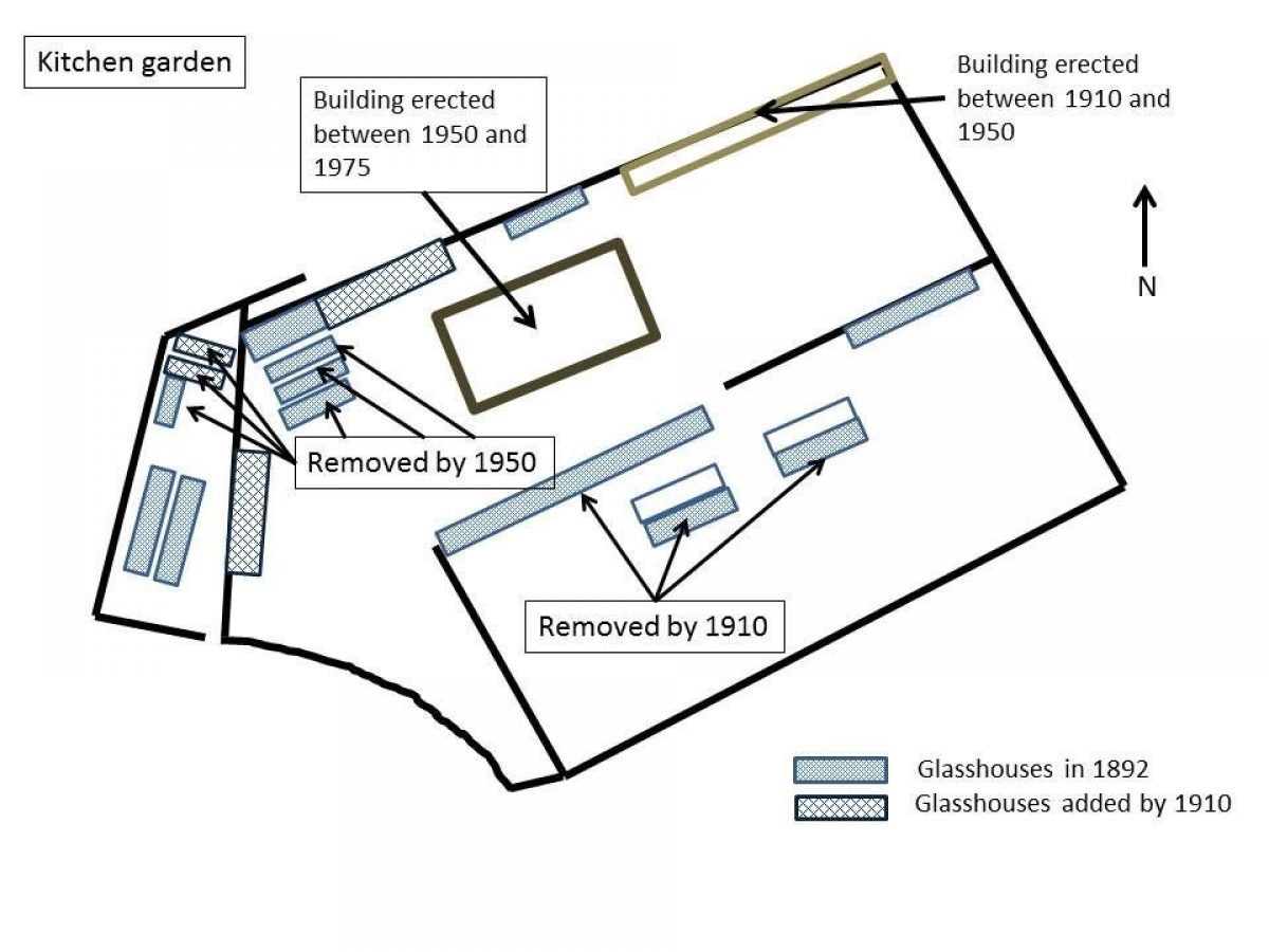
In 1829, a new greenhouse was built in the kitchen garden (3/9/17), although it is not clear whether this replaced any existing structures. On the 4 Jan 1845, John Underwood was paid for Glass for the Hothouse etc, £56 9s 8d (37/14). This was possibly to replace solid roofs with glass as the glass tax was in the process of being repealed. The images tab shows the development of the kitchen garden at this time from the 1st edition 6" OS map (surveyed 1846/7). Further work was undertaken in 1847, when Peter Theakston's men were paid £33 5s 6d for painting all the hothouses in the Gardens (37/14) and in 1848, when John Underwood was paid £103 13s for Glass and glazing in the Gardens (37/14). The next edition OS map of 1892 (see images) shows a significant number of new glasshouses in the northern section. One of these was built in 1854 when cement was bought for the new hothouse (37/13). The others may date from the remodelling done in 1883.
By 1910, the glasshouses in the southern section had been removed, with the exception of the one on the right hand side of the northern wall. However the one on the northern wall of the northern section had been expanded (see images). A photograph of the gardens, probably taken in the 1950s, shows the kitchen garden and its remaining glasshouses (Figure 9). By 1975, it was operated as a market garden but demolished in the 1990s to make way for housing.
Park
Escrick Park. an open area of parkland, south of the Hall, was created in the 1780s and extended in the 1820s. It is bounded on the west by the Selby-York road and on the east by the road to Skipwith, with its southern boundary being the woodland areas of Common Wood and Holly Carrs.
By the 1830s, there was a deer park that occupied most of the parkland. A ‘deer hovel' is marked on the 1st edition OS map just north of the carriageway from Stillingfleet Lodge and the boundary extended as far south as Denison's Lodge and the Menagerie. William White in 1840 (326) describes the estate as being ‘well stocked with deer, buffaloes'. In 1892, Whitaker (181) records that there are about 100 fallow deer and the park boundary is a fence and oak pales. He gives the acreage as 450 acres but this is the entire estate.
The Gashouse Plantation dates from the installation of the gashouse (and the removal of York Lodge?) in the 1870s (Taylor 1999, 117). Previously this had been open parkland with a belt of trees running along the western side.The Millhill Plantation was added in the 1820s when the Skipwith road was moved east, this forms a shelter belt along the north-eastern park boundary in between the two duck decoys. The Kennel Plantation - landscaping around the dog kennels and pond - probably dates back to the 1780s and the first phase of landscaping. It is shown on the 1808 estate map.
Other plantations include an Aviary Plantation , a Pond Plantation and Harrop's Plantation all put in between 1847 and 1892. Also the Fox Covert Plantation (Extant by 1847), the Old Road Plantation(also extant by 1847) and the Sheepwalk[s] Plantation, put in between 1847 and 1892
There are two Duck Decoy Ponds on the Escrick estate, both next to the Skipwith Road. The northern one may have been converted from an earlier fish pond of the 1760s. The southern one [Moor Head] was built around 1830, originally with 3 ‘arms', a fourth and an island being added in the 1850s (OA North 2009, 15).
Payne-Gallwey (1886, 179-80) noted the Moor Head pond was ‘compact, well-shaped, and planted', with features including ‘iron hoops, remains of the screens, and the Decoyman's hut' still in existence. The northern pond however he described as a ‘stagnant pool overgrown with rushes, no trace of pipes being observable', although at its peak, around 2000 fowl were taken from this latter pond in a season
Primary Sources
East Riding Archives
- HD26-28 Road diversions in Escrick 1825-6
- Escrick Estate
- Diaries of Beilby Thompson - 1763, 1764, 1774 & 1779-92
- Estate Accounts - 1763 to 1780
- Labourers Day Book - 1775 to 1780
Hull History Centre (HHC)
- U DDFA - Papers of the Forbes Adam/Thompson/Lawley [Barons Wenlock] family of Escrick Park
- 5/19 Valuation of farming stock and crops, late of Richard Thompson esq. dec'd., at Escrick and the Grange. (23 - 27 Sep 1820)
- 5/32 Bargain and Sale: Sir Henry Knyvett of Charleton co. Wilts to (his brother) Thomas Knyvett esq. (29 Jun 1586)
- 5/34 Confirmation. Parties as U DDFA/5/32. (1586)
- 5/39 Assignment of Lease: at £90 rent: Sir John Stanhope of Escricke to Sir Edward Mosley (15 Feb 1619)
- 5/40 Bargain and Sale: Thomas, Lord Knyvett of Escrick to Thomas, Earl of Suffolk K.G., and his son and heir Theophilus Howard, Lord Walden (17 Nov 1612)
- 5/52 Bargain and Sale: for £90: Edmonde Salvane of Thorpe Salvane esq., to George Gayle (24 Nov 1529)
- 5/127 Lease and Release: Edward, Lord Howard of Escrick and Henry Murray of par. St. Paul's, Covent Garden and wife Hon. Anne, to Sir Henry Thompson of York (7 - 8 Oct 1668)
- 5/133 Final Concord: for £1000: Sir Henry Thompson plaintiff and Edward, Lord Howard of Escricke and Henry Murray esq., and wife Anne deforceants (27 Oct 1668)
- 5/155 Lease for a year: Beilby Thompson of Escrick esq., to Rev. Christopher Spencer Brearey of Middleton esq., and Thomas Lloyd of Lincolns Inn gent. Manor and estate of Escrick: To lead to a Release to use. (18 Mar 1741)
- 37/7 Cash book (Household) (1744-1751)
- 37/13 Stewards acc book (1851-1856)
- 37/14 Stewards acc book (1842-1850)
- 37/15 Stewards acc book (1851-1856)
- 37/16 Stewards acc book (1857-1863)
- 37/28 Vouchers (1763-5)
- 37/29 Vouchers Yorks estates 150 items (1775)
- 37/31 Vouchers Yorks estates 400 items (1784)
- 39/43 Letters from William Boswell to R Thompson (1811-1816)
- 3/9/17 Account brickmaker and carpenters work (1821-36)
- 3/9/72 Photographs of gardens at Escrick (late 19th century)
- 5/11/2 Account of sundry improvements to estates (1820-1837)
- 5/11/21 Yorkshire and Escrick Park estates ledger (1881-1883)
Maps
- Estate maps c1630, 1754 and 1808
- Jeffrey's map of Yorkshire 1771, Plate 13
- Bryant's map of East Riding of Yorkshire 1829
- Ordnance Survey 1st 6" edition, surveyed 1846 to 1847, published 1851
- Ordnance Survey 6" editions, published 1892, 1910, 1950, 1975
Detailed description contributed by Yorkshire Gardens Trust 26/09/2016
- Visitor Access, Directions & Contacts
Telephone
+44 (0)1904 728252Website
https://www.escrick.com/
- History
Summary of Historic Interest
The designed landscape of Escrick Park has been developed over three centuries by its owners. From a 17th century manor house with adjacent small gardens in the centre of a village, the park evolved to reach its current proportions by the early-19th century. Now with the majority of its parkland and some of its pleasure grounds next to the Hall intact, it remains a suitable setting for the main house.
No specific designers have been attributed to the layout and so it would indicate that the owners, particularly Beilby Thompson II in the latter part of the 18th century and Paul Lawley Thompson in the 19th century, probably had a significant input. From the archival evidence, Beilby in particular was an enthusiastic manager of both the productive and ornamental parts of his estate. While the walled kitchen garden is largely demolished, the unusual twin icehouses remain intact as well as the two duck decoy ponds.
Historic Development of the Site
Estate owners
In 1323, the estate was divided between the four daughters of Roger de Lascelles. By 1344, three-quarters was being held by Ralph de Lascelles. The remainder was held by Avice Le Constable, who granted it to John Bardolf in 1339 and it became known as ‘Bardolgarth'. This part of the estate was bought by the Sandford family in 1372.
The last Lascelles to own the larger manor was Margaret who married James Pickering. It passed through the Pickering family until the marriage of Anne and Sir Henry Knivett [Kynvett] of Charlton, Wiltshire around 1537. Their son, Thomas, became Baron Kynvett of Escrick in 1607. His brother, Sir Henry, had transferred Escrick to him in 1586. Lord Kynvett died in 1622 and the estate went to his nephew and niece, Catherine. She had married secondly Thomas Howard, Earl of Suffolk and one of their sons, Edward, became Lord Howard of Escrick in 1628. Howard suffered financially in the Civil War and Interregnum and in 1668, he was forced to sell the estate to pay off his creditors.
The new owner was Sir Henry Thompson, a wine merchant from York. His descendants would occupy the hall for the next two hundred and fifty years and still own most of the estate today. His son, also Henry, inherited on his father's death in 1683 and rebuilt the old Hall.
Beilby Thompson inherited the estate in 1700 and by the time of his death in 1750, had done little to change the estate. His second wife (and mother of his heir, also Beilby) Lady Sarah Dawes though enlarged the Hall in the late 1750s and then brought in the architect, John Carr, in 1763 to undertake further work that was continued by her son. The removal of the church and other village buildings that followed the 1781 Enclosure Act, allowed Beilby II to start to create the parkland to the south.
Beilby had no direct heir and so Escrick became the property of his brother, Richard, in 1799. Following the latter's death in 1820, it was their sister's son, Paul Beilby Lawley, who inherited and changed his name to Thompson. He became the 1st Baron Wenlock (2nd creation) in 1839.
Lord Wenlock died in 1852 and was succeeded by his son, Beilby and on the latter's death in 1880 by his son, the 3rd Baron. By the start of the 20th century, the family started selling off parts of the wider estate and other possessions to pay death duties. The 3rd Lord Wenlock died in 1912, leaving a daughter, Irene, who decided to move to the nearby family property of Skipwith Hall in the 1930s. The Queen Margaret's School now own the Hall (having rented it from 1947) and some of the surrounding gardens.
Key owners:
Henry Thompson b1651 (1683-1700)
Lady Sarah Dawes/Thompson b1707 (1750-1765?)
Beilby Thompson II b1742 (1765?-1799)
Richard Thompson b1744 (1799-1820)
Paul Beilby Lawley Thompson [1st Baron Wenlock, 2nd creation] b1784 (1820-1852)
Beilby Lawley [3rd Baron Wenlock] b1849 (1880-1912)
13th to 17th Century
All references are from HHC UDDFA unless otherwise stated
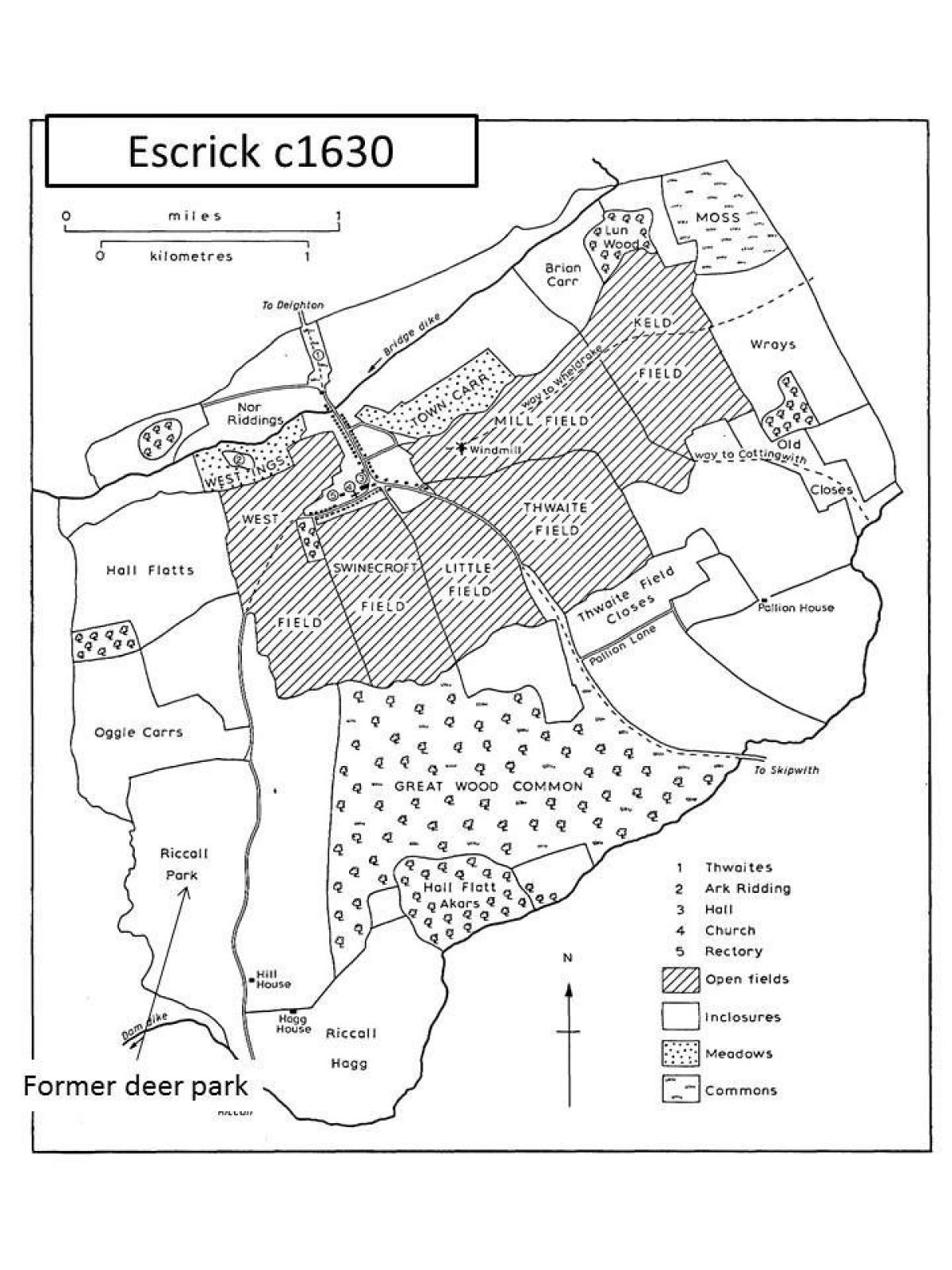
In the Domesday book, there were 2 manors each of 4 carucates (c480 acres), one called ‘Chetelstorp' and the other Escrick. These two manors were in an area that had woodland of 2*2 leagues (about 6000 acres) and was part of a Royal Forest that stretched from the River Ouse to the River Derwent. It was ‘disafforested' in 1234 and St Mary's Abbey enclosed a section to form a park by 1276, which later became known as ‘Riccall Park' (Neave 1991, 31).
The first mention of a (manor) house or ‘messuage' in 1339 (Yorkshire Deeds, 132) was in the ‘Bardolgarth' manor [the ¼ share first owned by Avice, see owners section above] and occupied by Gamelyn, a carpenter. In 1529, there is reference to the ‘manor and capital house called Bardolgarth' (5/52) when it is sold by Edmonde Sandforde to George Gayle, whose descendants sold it to the Knyvett family in 1584.
When the whole Escrick estate was transferred by Sir Henry Knyvett to his brother Thomas two years later, it was described as:
‘Three fourth parts of the manor and advowson of Escrigge, with their appurtenances in Escrigge' (5/32)
‘Manor, capital messuage or tenement called Bardalgarth in Escrigge with wood called West Garthe; and fourth part of woods called Lund and Holly Kirste. Fourth part of advowson of Escrigge.' (5/34)
Given the only ‘capital' messuage mentioned is in the latter part, the building that eventually became Escrick Hall would appear absent at this date.
There is a rental agreement of 13 February 1618/9 (5/39) between Sir John Stanhope to Sir Edward Mosley, of the following (which had been leased to Sir John by Thomas, Lord Knyvett for 21 years on the 13 February 1618/9):
‘Capital messuage of Escricke with closes called West Garth, the Herbers or Arbore near the Common Wood, Rayled Hall Flattes, Lowe Hall Flattes, Horse Pasture, the Lordes (Carr?), and three parts of Rickall Hagg; 5 oxgangs arable and 5ac. meadow; a wind corn mill and Blome Croft'.
This also appears to be referring to the Bardolgarth manor house, however it is not clear whether Lord Knyvett had built Escrick Hall by this time. However the Hall is there by the date of the estate map (c1630-1640) and in 1644 when the Earl of Manchester met other Parliamentary leaders at Lord Howard's house in ‘Eskrigge' on the 31 May (Taylor 2002, 28).
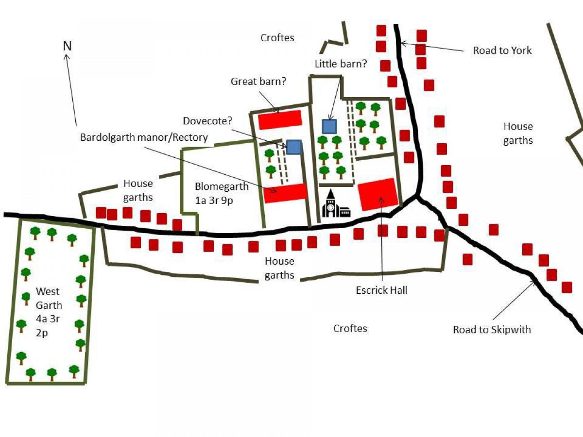
Escrick Hall lay in the centre of the then village in the mid-17th century. It was bounded on the south by the village road, on the east by village houses and on the west by the Church and graveyard (see images). There is a small area to the north that is depicted by trees that would appear to be a garden area. The area to the west known as ‘West garth' was described as a ‘wood' in 1586. The only other designed landscape is the former deer park, Riccall Park. Following the Dissolution, it was taken into Crown hands and then demised by the Crown to Thomas Knyvett on 11 April 1597 (5/40). Lord Howard acquired the park in 1630 from other members of Knyvett family (5/5) to increase his landholding the area (see images).
When Howard sold the estate to Sir Henry Thompson in 1668, it was described as:
Manor of Escrick with capital messuage, messuages, cottages, windmill and lands (Lord's Carre, Riccall Hagge, Bloome Croft and West Garth, Fogge Carre; Hither, Middle and Further Hall Flatts; Calfe Close; Horse Close, Buskett Close, Lund Wood, Horse Pasture, Hilly Flatt, the Ings, the Intake, Ricall Parke, Dighton Spring) (5/127)
Manors of Escricke and Bardolgarth with 20 messuages [later corrected to 60],10 tofts, 1 windmill, 1 dovecote, 40 gardens, 1500ac. land, 200ac. meadow, 1000ac. pasture, 400ac. wood, 1000ac. heath and furze (5/133)
17th and 18th Centuries
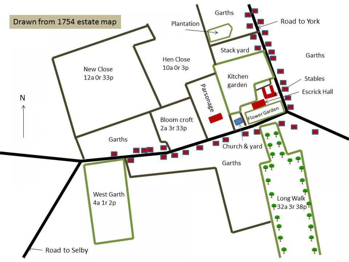
Henry Thompson rebuilt Escrick ‘Old Hall' between 1680 and 1690 and a sketch of it was made in the 1720s (40/41). The picture shows part of a walled forecourt to the south with gatepiers opposite the main entrance of the house and a small garden building on the right hand side. By the time of the 1754 estate plan, this area is described as a ‘Flower Garden' (see images).
Beilby Thompson bought some more land in the Escrick parish from Sir Thomas Legard in 1726 but he appeared to do little else in terms of landscaping the estate, judging by the mid-18th century map. In 1741, the year of his marriage to Sarah Dawes, he rented out the estate (5/155) and from 1745 would appeared to be living in Missenden (Bucks) and also Hampton Hall [possibly the property just outside Bath], according to the accounts of the time (37/7).
The most prominent feature in the landscape by 1754 is the ‘Long Walk' (see images) starting opposite the Hall and heading south between Swinecroft and Little Fields. It first appears on the 1754 map but may date from earlier as such formal avenues were popular from the 1680s. It consisted of two lines of elm trees: the Labourers Day Book records the removal of some of these in 1776. There is also a significant (possibly walled) kitchen garden shown to the north of the house. By 1758, this had a large stove (see kitchen garden section).
The house was remodelled in 1758 by Lady Sarah Dawes [date stamp on drain pipe] with further alterations by the architect, John Carr, between 1763 and 1765. At the end of the Long Walk, there was a Menagerie as shown on 1771 Jeffery's map and in the following Carr accounts for October 13-24 1763, it states:
‘At Escrick to consider the new Plans & was ordered to make a General Plan of the whole Ground about the house, and setting out the way to the Menagerie etc' (37/28)
Beilby Thompson II records in his diary visiting Kew Gardens and Plumpton Rocks in 1764 (as well as Castle Howard and Bramham in 1774), so perhaps he was looking for design ideas. However he was constrained by the position of the Hall, which was still surrounded by other buildings as well as the village road. He continued though to make improvements and had installed an ice house by 1764. If it is one of the existing pair, depicted on the OS map surveyed 1846/7, it was located in the top left section of ‘Blomegarth'.
On the 2 January 1765, he paid Thomas Simpson ‘in full for digging Fish Ponds, raising a Mount and Choping Bark £397 11s 7d' (Estate Account Book). There were 6 fish ponds mentioned later in Bielby Thompson's farm diary (1779-92):
- ‘Garden' - in former kitchen garden, shown on 1808 map but gone by 1846
- West Field adjoining road to Riccall - possibly the pond at SE 625 415, shown on 1958 OS map but now gone
- Parson's Garth - pair of ponds west of New Bridge, extant by 1846 but gone by 1892
- New Close - to north-west of house, irregularised by late-19th century but still extant
- Car - became the northern decoy pond?
- Dog kennel area - not shown on maps prior to 1975 but still extant
The site of the ‘Mount' could be the area just south of Bentley Wood that is marked on the 1829 Bryant and the 1st edition OS 6" map. The latter shows a small raised mound next to an L-shaped piece of water called ‘Mount Pond'.
By 1774, John Carr had returned to complete the new stable block and this coincided with further work in the landscape. On the 11 April, Thompson records in his diary that he ‘sent the servants to plant a good many young oaks in Joys Lund which were taken out of the Garden'. He also ordered a significant amount of trees and shrubs from Telfords of York (37/29) in early 1774. The shrubs and smaller trees may have been planted in the area labelled ‘garden' on the 1808 map to the east of the kitchen garden. However the larger trees were relatively expensive and cost from 3d for the larches, 6d for the firs and elms to 1s for the striped horse chestnuts. Using a contemporary catalogue from the Perfect's nursery of Pontefract, this would indicate they were at least 8 foot tall and so more likely to have been used for the new parkland.
In 1775, there are the first records of the removal of village houses to the south of the Hall to create the parkland. Throughout 1776 and 1777, there are references in the Labourers Day Book to removing old trees and fencing the new closes, as well as removing some of the elms from Walk (the section nearest the Hall). Finally in 1781, with the Enclosure Act, Thompson was able to expand the designed landscape west, by removing the church and rectory to the north of the village. He also gained (glebe or church) lands to the north of the kitchen garden, which allowed him to enlarge it.
In late 1791, Thompson records further work in his diary in the small park and garden now surrounding the Hall:
Planted a good many cuttings from the Portugal & Com[mon] Laurels in the Garden. They all died - were planted too late (1 Nov)
Very busy in planting different sorts of Firs, Forest Trees and Ever Greens on the East side of the Stables - against Hopkinsons Yard (3 Nov)
19th Century
Beilby's brother, Richard, succeeded him in 1799 and during his twenty-one year tenure added the Ionic Temple around 1812. On the 20th August of that year, William Boswell [his steward] writes to Richard Thompson: 'We shall get the Walks done by the usual time of your coming here but I am sorry to say I fear the Temple won't be finished by that time' (39/43).
By 1820, there were 130 deer recorded on the site (5/19), so it is possible the northern section of the parkland had become a deer park by this stage. However this must have been after 1808, as it is not shown on the estate map of that date.
When Paul Lawley [Thompson] inherited Escrick from his uncle in 1820, he continued reshaping the land to the south of the Hall to create the present park. In 1822, the Menagerie was converted into two farmhouses (3/9/17) and £650 was spent on (‘Forest') trees, together with labourers' bills of £1000 for planting and fencing woods (5/11/2). The following year, a new lodge was built for ‘John Denison... adjoining Temple and thatched with reeds, a very neat place' (3/9/17) and in 1824, there was ‘a new Lodge built at entrance of Isaac Rush Wood and thatched with reeds complete' (3/9/17) [Wood Lodge]. This was the start of the new route from the south through the new park to the Hall (see images). In these two years, about £300 was spent on trees and £4250 on other costs related to making the park (mainly labourers' wages).
In 1825, Thompson got permission to move the Howden road further east and in 1826, the Selby road west so he could increase the park even further at its northern extent. The plans submitted (ERA HD 26, 27 & 28) show that even at this stage a few houses remained along the old village main street to the west. These were presumably removed soon after, as Mr Jelly [estate steward] was built ‘a New Lodge called Escrick Park Lodge' [Stillingfleet Lodge?] by 1828 (3/9/17).
Before 1847 (1st edition 6" OS), the parkland increased again to link up with ancient woodland - Holly Carr, Common Wood and Hart Nooking to make 450 acres in total. This may well have been done by 1829, when the new lodges were built at Riccall Bridge, to complete the drive through, past ‘Approach Farm' with its Avenue (possibly the one referred to that was fenced in 1830/1, 3/9/17).
Thompson engaged the services of Sir Edward Blore to remodel the house in a Gothic style in 1839 but the designs were never implemented. A sketch made around 1831 and published in Thomas Allen's A New and Complete History of the County of York Volume 4, shows the Hall with terracing and balustrade wall to the south front and a conservatory on the west side. The main entrance has been moved to the eastern front. Allen (1831, 128) comments:
The village of Escrick is without exception one of the neatest in the county. It is the property of the lord of the manor; and to the highly cultivated taste and spirited exertions of Mr. P.B. Thompson, the great improvements made in Escrick during the last few years, must be mainly attributed. The buildings of the village have all the neatness of the Swiss cottages without their formality and it is a fine specimen of an English village.
Escrick park, the seat of PB Thompson Esq MP, is of considerable extent; the ground is highly diversified with hill and dale and the timber is in excellent condition. The hall is a large and handsome edifice the principal front is plain with retiring wings the centre having balustrades and vases at the angles.
To the west of the house were the pleasure grounds and in 1842 a ‘root house' was erected there (37/15). It had a thatched roof and its rustic style was presumably meant to complement the lodges and Gardener's House. About 1830, the Morehead duck decoy was put in, attributed to George Skelton by Payne-Gallwey (1886, 179) and in operation until 1860. A second decoy pond, near the entrance on Skipwith road was also put in before 1846.
There were further alterations to the main house. The north-west wing was added 1846-7, the north-east wing around 1849 and alterations were made to the east side in 1851. In 1858, the current terraces to the south were laid out (37/16), possibly also the urns that are now part of the listing for the Hall and its associated buildings. At the same time, in the pleasure grounds a ‘tank' [probably circular pool that has recently been excavated] was added and further work was done on the rockery (37/16).
The kitchen garden was remodelled in 1883 (5/11/21) with the old walls and buildings removed. By 1892 (as shown on 2nd edition OS map), there was a second icehouse, the East Lodge and further changes were made to the pleasure grounds.
20th Century
The area of parkland started to reduce and was shown as 430 acres by the 1910 OS map. In 1898, the family acquired the nearby Skipwith Hall estate and this became their main home in the 1930s. In 1929, the Hall was turned into flats. In the advertisement for the latter, the gardens are described as follows (Taylor 1999, 152):
The gardens are well known for their beauty, consisting of about 26 acres of lawns planted with exceptionally fine old trees-especially cedars, yews, beeches; there are also rose-gardens, secluded rhododendron and lily gardens...ornamental water, orchard and plantation.
The Hall was let to Queen Margaret's School in 1947, who then purchased it in 1974. The former kitchen garden was sold and houses built on the land in the 1990s.
Detailed history contributed by Yorkshire Gardens Trust 26/09/2016
Period
- 18th Century (1701 to 1800)
- Late 18th Century (1767 to 1800)
- Associated People
- Features & Designations
Designations
Conservation Area
- Reference: Escrick
Features
- Ionic Temple
- Pond
- Topiary
- Country House (featured building)
- Description: The original late-16th/early-17th century house was pulled down and replaced with the current house around 1680-90. It was altered in 1758 and 1763-1765 (the latter changes by John Carr).
- Earliest Date:
- Parkland
- Woodland
- Key Information
Type
Park
Purpose
Ornamental
Principal Building
Domestic / Residential
Period
18th Century (1701 to 1800)
Survival
Extant
Hectares
182
Civil Parish
Escrick
- References
References
- Landscaped Parks and Gardens of East Yorkshire, 1700 - 1830
- A New and Complete History of the County of York Volume 4.
- The East Riding of Yorkshire Landscape
- Guide to the Conservatory
- The Ladies' Magazine of Gardening, 361
- Escrick Park Estate: Archaeological and Historical Survey
- Escrick Decoys Ponds
- The book of duck decoys, their construction, management, and history
- A Catalogue of Forest-Trees, Evergreen and Fruit Trees, Flowering Shrubs, sold by William and John Perfect, Pontefract, Yorkshire
- Escrick A Village History
- Principles of Warming and Ventilating Public Buildings
- A Descriptive List Of The Deer Parks And Paddocks Of England
- History, gazetteer and directory of the East and North Ridings of Yorkshire
Contributors
Louise Wickham
Yorkshire Gardens Trust