Introduction
The site has pleasure gardens, parkland and formal gardens of 6 hectares laid out in 1738 and subsequently altered in the 1920s and 1930s. The parkland originates from the 13th century and was landscaped in the 18th and 19th century.
Terrain
The site lies on gently undulating land at the foot of the scarp of the South Downs. The ground falls generally across the site from the north-west towards a valley which runs the length of the south-east boundary.www.historicengland.org.uk/listing/the-list
Mid to late C19 and early C20 formal and informal gardens set within an C18 park which is probably of medieval origin.
DESCRIPTION
LOCATION, AREA, BOUNDARIES, LANDFORM, SETTING
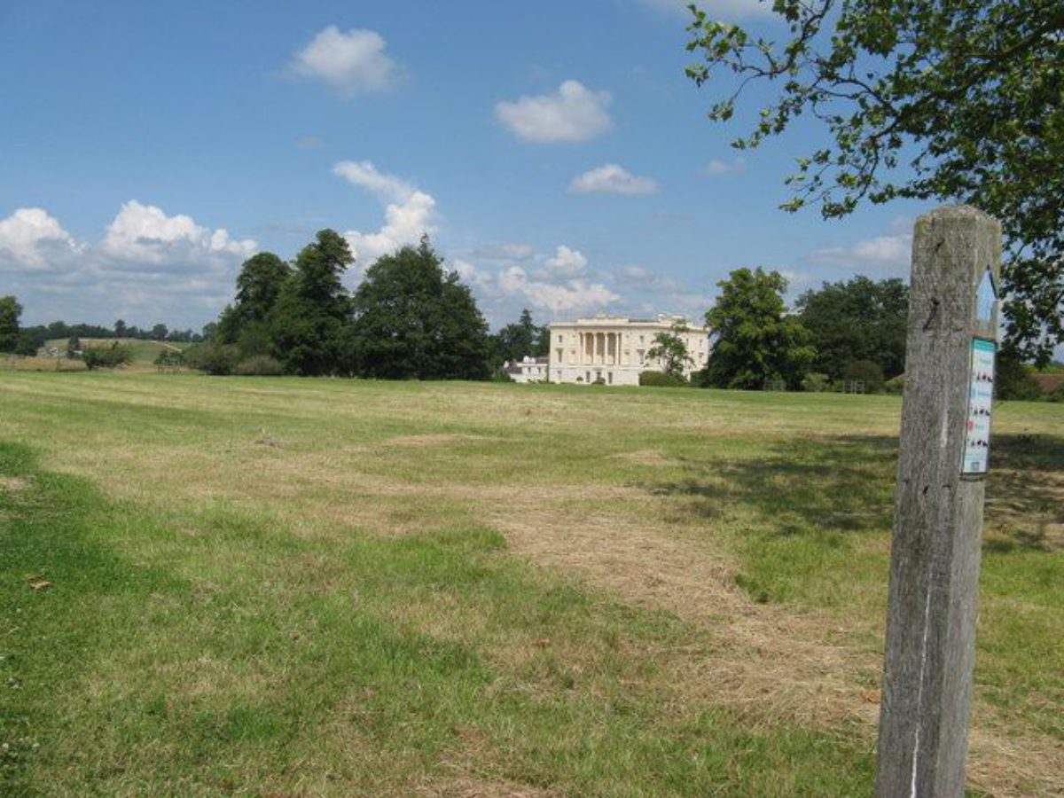
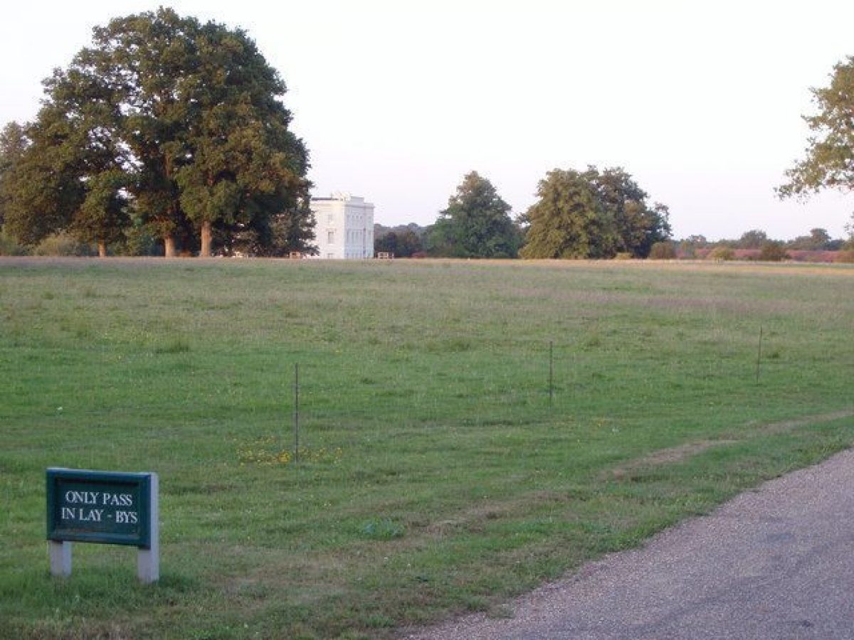
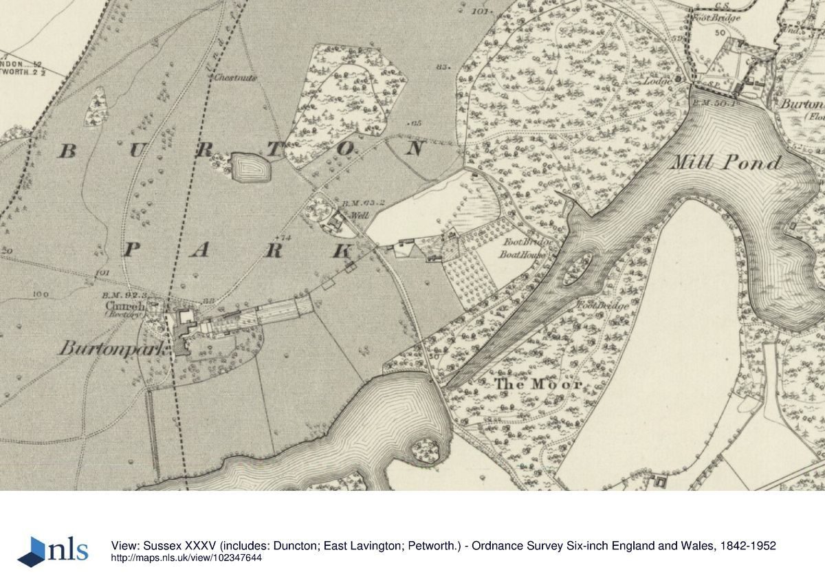
Burton Park is situated on the east side of the A285, c 3km south of Petworth. The c 140ha site, comprising c 4ha of formal and ornamental gardens and c 136ha of parkland, farmland, woodland and a lake, lies on gently undulating land at the foot of the scarp of the South Downs which rises steeply to the crest within 0.5km of the southern boundary. The ground falls generally across the site from the north-west towards a valley which runs the length of the south-east boundary and which contains two linear lakes, the western wooded shores of the northern lake (Mill Pond) forming the site boundary. On the west side, the boundary is formed by a mature hedgerow and on the north side by a minor lane, the whole site being set in a landscape of wooded farmland.
ENTRANCES AND APPROACHES
The main entrance to the site is from the A285 to the west, some 200m to the north of Duncton village, at double wrought-iron gates framed by stone piers (gateway listed grade II) and further curved wings of iron fencing which were probably erected by Major Courtauld and flanked by a lodge on the north side. A drive, shown established, with a building in the position of the present lodge, by 1874(5 and now (1998) bordered by an avenue of evergreen shrubs, follows a c 350m serpentine course through East Wood before crossing the park and turning north-eastwards to pass the north-west side of St Michael's church (listed grade I). South of the church, a spur from the drive leads due east to the forecourt on the entrance front of the house. North-east of the church the drive, shown on the 1st edition OS map, continues as a surfaced route for c 700m to Black Pond Copse and then as public footpath to Burton Mill Lodge (built between 1874(5 and 1898) in the far north-east corner of the site. A gently winding secondary drive, also established by 1874(5 and now closed to through traffic, enters at North Lodge (1km north of the house) which was built between 1874(5 and 1896 (OS 1st and 2nd editions).
PRINCIPAL BUILDING
Burton Park (listed grade I) stands south-west of the centre of the site, on level ground and with its principal entrance front facing west. A Tudor house, destroyed by fire in the mid to late C18, is thought to have stood further to the west (CL 1936). Built c 1828 by Henry Bassett in a neo-Grecian style, its three storeys are faced with stucco. The ground floor on the west front is rusticated while the central portion of the upper floors is recessed to form a loggia supported by four fluted Ionic columns and topped by a high balustraded parapet. Bassett's house incorporates probably the main hall and part of the east wing of a former house on the site, designed by Giacomo Leoni (1686(1744) in 1739, which in 1826 was also largely destroyed by fire. The house and the adjacent stable courtyard to the north are at present (1998) being converted to private apartments and dwellings with additional new dwellings, known as Burton Court, located to their east.
GARDENS AND PLEASURE GROUNDS
The formal gardens and pleasure grounds lie to the east and south of the house. From the east front, the house opens onto a series of four descending terraces connected by flights of stone steps which were built in the early 1920s to replace a former sloping bank. The terraces are retained by, and are enclosed along their south side by, coursed sandstone walls with an hemispherical dipping well being built into the south wall at the southern end of the second terrace level. The third level, which extends eastwards to form a square (now, 1998, enclosed on the north side by Burton Court), is laid out as a rose garden in a geometric pattern of random-squared stone paving and beds (under restoration in 1998). Steps lead down from the north-east corner of the rose garden onto the lowest terrace which is laid out with two symmetrical oblong lily pools at the north and south ends, the northern pool constructed between 1896 and 1910 and formerly containing a fountain, the southern pool added in the early 1920s. The pools are connected by a stone water rill with, as its centrepiece and sited on the axis of the steps to the third terrace.
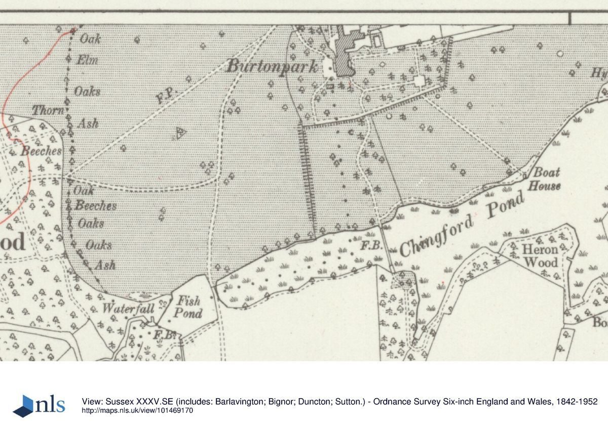
From the terraces, steps lead down onto an open bowling or croquet lawn and to further lawns which extend 100m eastwards to a ha-ha (established by 1837(40, Tithe map) and which are dotted with individuals and clumps of mature conifers including cedars and yew, these plantings surviving from a mid to late C19 layout (Tithe map, 1841; OS 1st edition 1874(5). The north side of the lawns is enclosed by the south wall of the kitchen garden, the conservatory shown in 1874(5 having been replaced by the present shrub border in the 1920s. The south side of the lawns is bounded by a gravelled walk running along the top of the continuation of the ha-ha while some 30m northwards, a further path (laid out by 1874(5) runs east to west across the lawns to terminate at its east end in a stone seat which formerly formed a feature within a yew-hedge-enclosed rose garden, laid out between 1896 and 1910 (now, 1998, largely gone). Westwards, this path runs beneath several pergola arches supported on brick piers which were constructed in the early 1920s and formerly flanked by borders of azaleas and herbaceous plants.
From the south elevation of the house, south of a former continuation of the ha-ha (this section was filled in by the mid C20), lawns extend southwards towards a lake known as Chingford Pond. The central axis was formerly marked by a grass and stone-paved walk flanked by herbaceous borders and yew hedges, laid out in the 1920s and removed in the mid C20. The southern length of the axis, c 130m from the house, is flanked by a coppiced nut walk, probably dating from the 1920s (Ford 1995) which terminates in brick steps leading down to a semicircular landing on the lake shore. West of the nut walk are tennis courts (to the north) and an orchard (to the south) while east of the walk and enclosed within light, ornamental woodland, a stone path leads from the lawns into a rock garden, laid out on the slopes down to Chingford Pond with winding rocky paths and remnants of former ornamental herbaceous planting. It is intended to restore the rockery, nut walk and landings in 1998(9.
PARK
The park surrounds the house on all sides. It is depicted on Saxton's map of the counties of Sussex, Kent and Surrey of 1575 and was probably established by the Goring family between 1550 and 1570 (Sussex Notes and Queries). To the north-west and north, areas shown as planted with parkland clumps in 1795 (Gardner and Gream) are now under arable cultivation, with only occasional individuals and clumps of trees surviving from the more extensive pattern shown from 1874(5 to 1914 (1st and 3rd OS editions). To the north-east, 150m beyond the house, Black Pond (shown on the Tithe survey of 1837(40) is fringed with trees and abutted on its north-east side by the deciduous wood of Black Pond Copse (established by 1795). East of the Copse and extending to the boundary of the site is a further wood, New Piece and New Piece Moor, established as woodland by 1813 (OS Old Series map). New Piece Moor consists largely of birch and alder with an understorey of bracken and was partly replanted in the 1990s, while New Piece contains chestnut coppice, hornbeam, birch and oak; together they form a nature reserve managed by the Sussex Wildlife Trust. South of New Piece Moor, a range of former estate buildings around an open green, recorded on the Tithe map as Lodge Green, were converted and extended in number in 1997 to form private housing; part of the present open parkland south of the new houses on the south side of Lodge Green (along the eastward continuation of the main drive to the site boundary) was occupied by the late C18 kitchen garden (OS Old Series 1813), shown replaced by an orchard by 1875 (OS 1st edition).
To the south and south-east of the house and gardens, further open grassland slopes gently down to Chingford Pond and, separated from it by a dam at the western end, a small fishpond. Chingford Pond, fringed by trees on the north-west shore and by mature woodland on the south-east shore and with its western end heavily silted up, is shown (with the Mill Pond, outside the site boundary to the north) on Gardner and Gream's map of 1795 but may have been created with the building of the Leonie house in the 1740s (Williamson 1995). Its eastern dam carries the remnants of an elaborate rockwork cascade with tunnels and grottos, probably of the same date but now heavily overgrown.
KITCHEN GARDEN
The kitchen garden lies immediately east of the formal terraces, on the north side of the east lawns. Its approximately 80m x 40m rectangle is enclosed by high brick walls, with the principal entrance, through wrought-iron gates, on the south side. Its ground plan and north and south walls appear to date from the late C18 or early C19 date (shown on the OS edition of 1813) while the present east and west walls were rebuilt in 1997, the east wall being moved a few metres west to accommodate the courtyard houses built to its immediate east in 1997. The garden is at present (1998) undergoing restoration to a formal layout with an east to west water rill and pool, the former layout of a central, double herbaceous border established in the 1920s (following removal of the C19 glasshouses in c 1919) being replaced by school buildings in the mid C20.
REFERENCES
Sussex Notes and Queries 20, (1868), p 232
D G C Elwes, The Castles and Mansions of Western Sussex (1876), pp 56(8
W D Pike (ed), Sussex in the Twentieth Century: Contemporary Biographies (1910), p 132
Country Life, 80 (11 July 1936), pp 38(43
I Nairn and N Pevsner, The Buildings of England: Sussex (1965), pp 38(43
E Ford, Burton Park, Petworth, A Landscape Appraisal (1995)
T Williamson, Burton Park, Sussex: A Report on the Historic Landscape (1995)
R H Allen, Land at St Michael's School, Burton Park, a landscape and ecological appraisal (1995)
Burton Mansion House and Burton Court, sale particulars (1997)
Maps
R Budgen, An actual survey of the County of Sussex divided into Rapes ..., 1" to 1 mile, 1724
W Gardner and T Gream, A Topographical map of the County of Sussex ..., 1" to 1 mile, 1795
Tithe map and survey for Burton and Barlavington parishes, 1837(40 (West Sussex Record Office)
OS Old Series 1" to 1 mile, published 1813
OS 6" to 1 mile:
1st edition surveyed 1874(5, published 1880
2nd edition published 1898
3rd edition published 1914
OS 25" to 1 mile:
1st edition surveyed 1876
3rd edition published 1912
Archival items
Photographs dating from the 1920s from a private collection held at Cooke's House, West Burton (qv).
Description written: March 1998
Amended: January 2000
Register Inspector: VCH
Edited: June 2000
- Visitor Access, Directions & Contacts
- History
The following is from the Register of Parks and Gardens of Special Historic Interest. For the most up-to-date Register entry, please visit the The National Heritage List for England (NHLE):
www.historicengland.org.uk/listing/the-list
HISTORIC DEVELOPMENT
Burton Park may owe its origin to Sir William Dawtrey who held land known as Bodeketun in 1242. The property descended to Sir Edward St John of Barlavington and then to John Goring (d 1520), whose family probably built the first house on the site. The last member of the Goring family, Sir William, died in 1724 and, his sister having married Richard Biddulph of Staffordshire, Burton Park passed to that family, Richard Biddulph building a new house on the site. His nephew, John Biddulph, succeeded and in c 1828, following its partial destruction by fire, rebuilt the house to its present form and laid out pleasure grounds to its south and west. In 1835 the estate passed to Anthony Wright-Biddulph and in 1894 was bought by Sir Douglas Hall who further developed the gardens (Ford 1995) before selling in 1919 to Major and Mrs Courtauld. They added new formal features to the gardens. The house and park were requisitioned for wartime use by the army and in 1945(6 the house, gardens and southern half of the park were sold to St Michael's School who remained in ownership until selling in 1993 to three development companies. The house is now (1998) undergoing conversion to private apartments with additional new dwellings in its immediate grounds and in the park, the intention being for the parkland to be managed for communal, private use. The remainder of the park to the north passed through a number of ownerships including that of a timber haulage company (Green's) and the Percy Woodward Trust, until the majority of it was purchased by Mr de Heger in 1960. It remains in private ownership. The north-east corner, known as New Piece and New Piece Moor, was purchased in 1977 by the Sussex Wildlife Trust and is managed as a nature reserve.
- Associated People
- Features & Designations
Designations
The National Heritage List for England: Register of Parks and Gardens
- Reference: GD2214
- Grade: II
Features
- Pleasure Garden
- Parkland
- Formal garden
- Key Information
Type
Park
Purpose
Ornamental
Hectares
106
Open to the public
Yes
Civil Parish
Barlavington
- References
References
- {English Heritage Register of Parks and Gardens of Special Historic Interest}, (Swindon: English Heritage, 2008) [on CD-ROM] Historic England Register of Parks and Gardens of Special Historic Interest
- Nairn, I. and N. Pevsner, {The Buildings of England: Sussex} (Harmondsworth: Penguin Books, 1965), pp. 38-43 The Buildings of England: Sussex
- Elwes, D. G. C., {A History of the Castles, Mansions and Manors of Western Sussex} (London: Lewes, 1876), pp. 56-8 A History of the Castles, Mansions and Manors of Western Sussex
- Historic Land Management {Burton Park Restoration Plan} (2003) Burton Park Restoration Plan
- Phibbs, J. {A list of landscapes that have been attributed to Lancelot ‘Capability’ Brown} (Garden History, 2013) 249 A list of landscapes that have been attributed to Lancelot ‘Capability’ Brown