Introduction
Petworth House has a 16th- and 17th-century park and ornamental pleasure grounds, which were both landscaped by Lancelot Brown between 1752 and 1756. The landscape features in many works by Turner.
Terrain
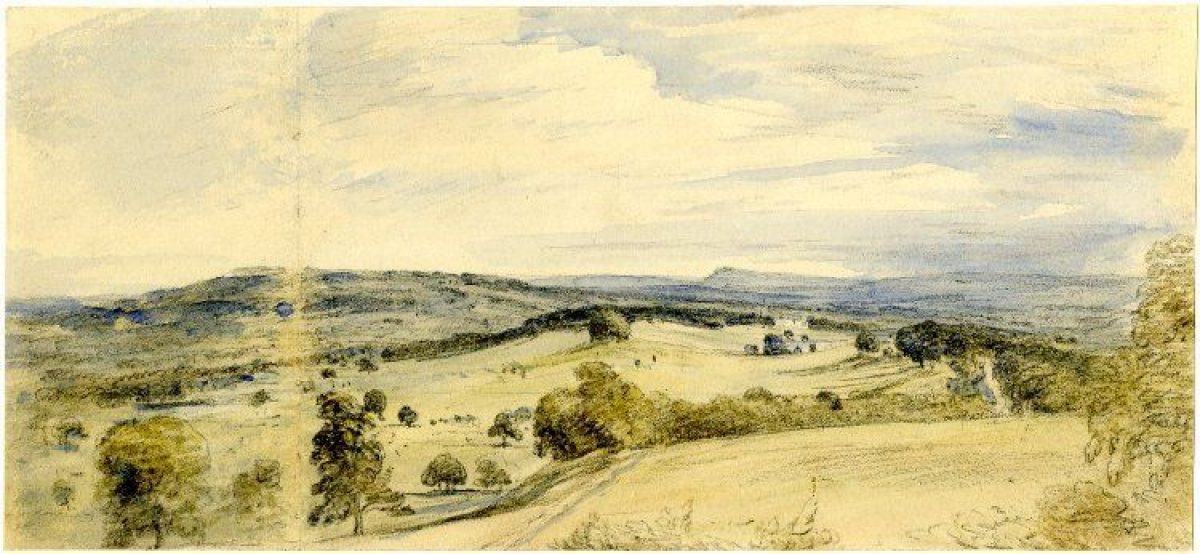
The site occupies the floor and sides of a broad valley which winds northwards between steep slopes.www.historicengland.org.uk/listing/the-list
DESCRIPTION
LOCATION, AREA, BOUNDARIES, LANDFORM, SETTING
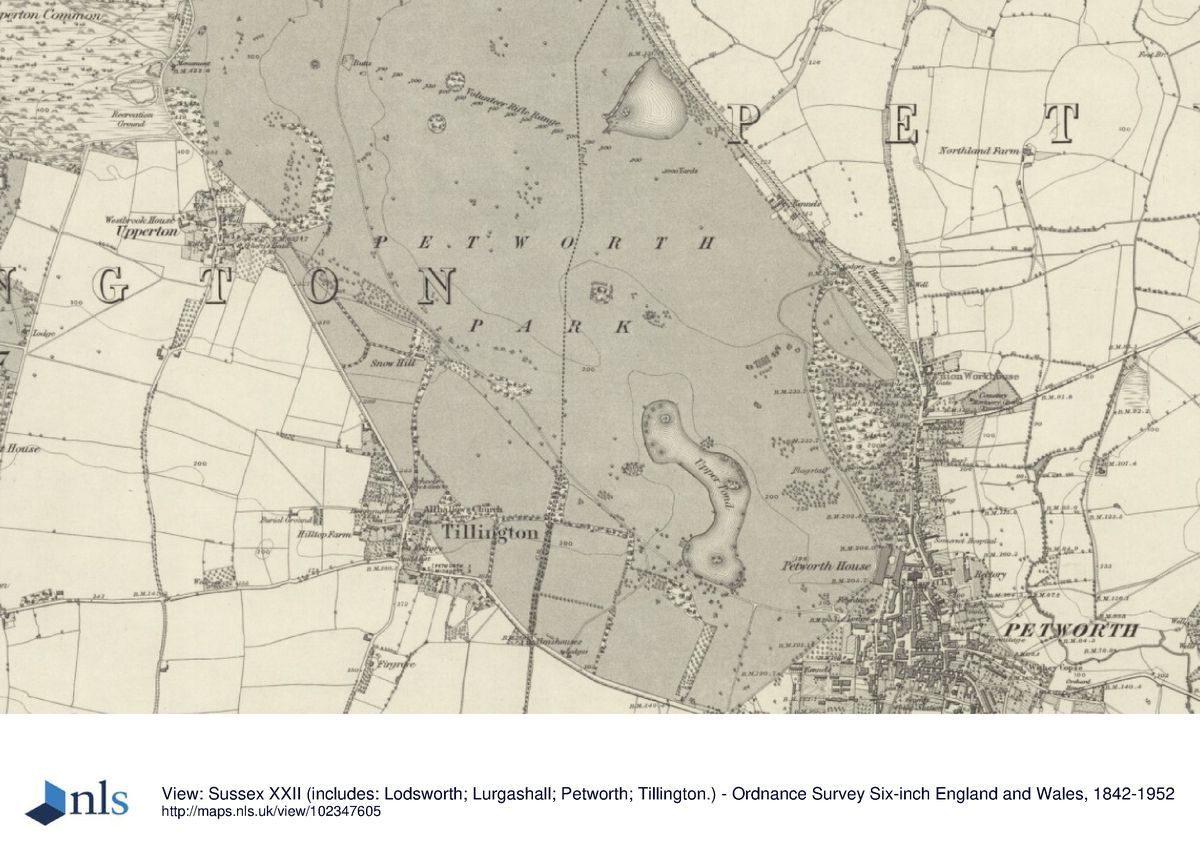
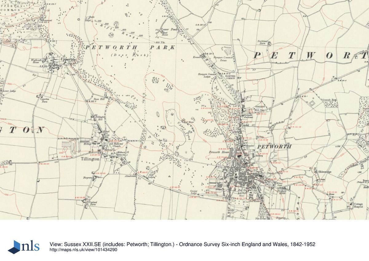
Petworth House lies immediately adjacent to the north-west edge of Petworth, between the main A283 road running north to Godalming and the A272 westwards to Midhurst. The 294ha registered site comprises c 18ha of ornamental and kitchen gardens and 276ha of parkland and occupies the floor and sides of a broad valley which winds northwards between steep slopes which rise to a high ridge along the north-west boundary and a high promontory which projects north-westwards into the centre of the park. The north end of the promontory (Arbour Hill) descends in a steep slope to a broad plain which is enclosed by the ridge to the west and by further rising ground on the northern boundary. The park is entirely enclosed by a high wall, some 8km in length, most of which was probably built c 1756-63 (guidebook; the lengths along the A272 from the south-east corner of the site west to New Lodges, and northwards on the A283 from the House to Hampers Common Lodges, are listed grade II). Roads abut the park walls on all boundaries except that to the north-west and in the south-east corner where estate and town buildings including the church, intervene. The park is surrounded by an undulating landscape of wooded farmland and enjoys extensive views to the South Downs to the south-west.
ENTRANCES AND APPROACHES
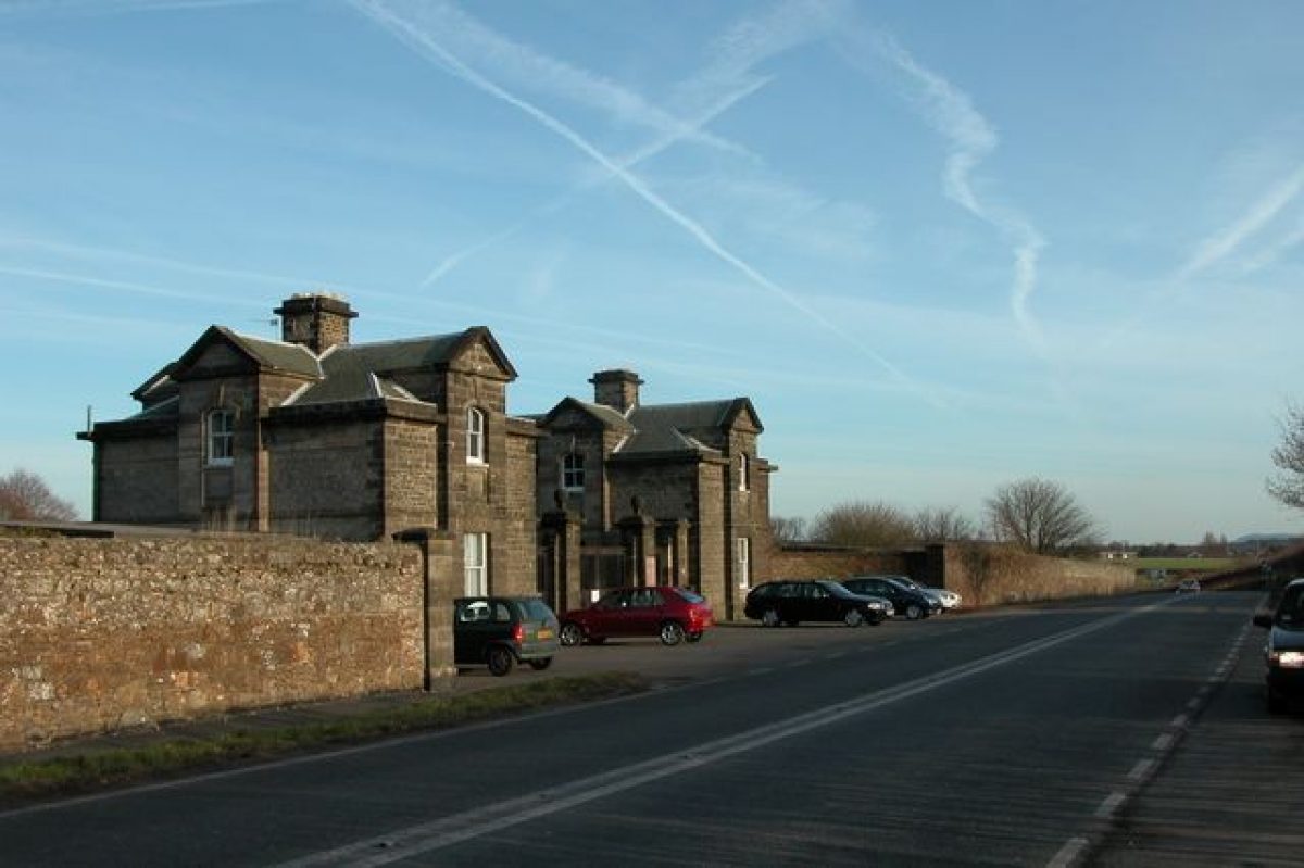
The formal approach to the House is from the town, through carriage entrance gates standing 90m south of the House which face south down Pound Street; they are flanked by two pairs of rusticated piers, the outer pair topped by trophies and helmets (shown on the west front entrance gate to the House in a view of c 1700 and listed, with an adjacent C18 lodge by Matthew Brettingham (1725(1803) and walling at grade II*). From the gates, a gravelled drive flanked by holly hedges and a lime avenue runs northwards to the porte-cochère extending out from the east front of the House. Until the establishment of this entrance in 1872, the House was approached on its west front. Treswell's map of 1610 shows the principal route crossing the park from an entrance at the extreme north-west end which, by 1649 (An Ocular draught of the Home Park ...) had been formalised into an avenue and a parallel but winding coach road. Brown's improvements retained the west front approach, his plan of 1752 showing it served by two drives from the north-west. One ran down the east side of the park, along the west side of the Pleasure Grounds, although by 1779 (Crow's map) this drive extended only as far north from the House as the park entrance on the eastern boundary at the two-storey, ashlar Hampers Common Lodges (Matthew Brettingham late C18, listed, with their gate piers, grade II). Brown's proposed drive down the west side of the park (1752 plan) is shown following a slightly revised course on Crow's 1779 map, by which time the re-routing of the road from Petworth to Tillington (A272) southwards to its present course had occurred and the park been extended southwards (the road, with its boundary wall, was constructed by Brown in 1762). The present western drive follows a course similar to that shown in 1779, although alterations were made to its southern end in the late C19 (NT 1985). Cricket Lodge (listed grade II), probably built in association with the Brown's new road, stands 250m west of the south-east corner of the park with, some 550m further west, New Lodges (listed, with their gates, grade II) which appear to have been built between 1869 (Upton's plan) and 1875 (OS 1st edition OS).
PRINCIPAL BUILDING
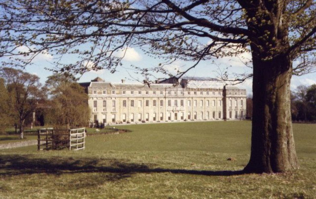
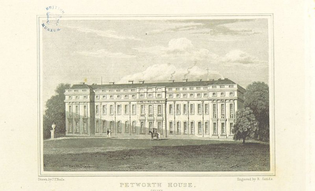
Petworth House (listed grade I) stands on level ground at the extreme south-east end of the park. Built of local freestone ashlar with ornament in Portland stone, the main 96.6m long west front is three storeys high with a mansarded slate roof and with its central three window bays flanked by rusticated pilasters. A house which stood on the site in 1309 (the present house incorporates the east wall of its chapel) was enlarged or rebuilt in 1576-82 and again after 1621, the main body of the present house, including the great west facade, being built from 1688 to 1693, possibly by the architect Daniel Marot (1661-1752). The exterior remained largely unaltered until the addition in 1820 of the North Gallery (possibly by Sir John Soane, 1753-1837) to house paintings and sculpture. From 1869 to 1872, the architect Anthony Salvin (1799-1881) rebuilt the south-east end, adding a porch and porte-cochère which linked the House across a courtyard to the Old Estate Office (enlarged by Salvin, listed grade II) and the two-storey, rectangular, ashlar Servants Wing to its north (probably contemporary with the 1688 rebuild, listed grade II*). The west and east stable wings (west wing C18 by Matthew Brettingham but within a complex of earlier outbuildings, both wings listed grade II*) form a triangular courtyard immediately south of the Old Estate Office with, at their northern end and facing east into Church Street, a mid C19 cottage known as the Visitor's Entrance (listed grade II).
GARDENS AND PLEASURE GROUNDS
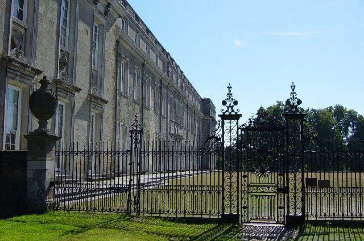
The ornamental gardens lie to the north and south of the House, those to the south enclosed from the park by a stone ha-ha, built between 1875 and 1898 (OS 1st and 2nd editions) and planted with an evergreen shrub belt which curves south-westwards from the wrought-iron screen and gate (one of a pair, modelled on those by Tijou at Hampton Court, framing the west front and erected in 1872) to meet the north-west corner of the kitchen garden. Some 140m along its course from the House, early C19, cast-iron double gates (listed grade II) form an entrance into the park from the gardens which are informally laid out to lawns dotted with trees and shrubbery and, some 40m to the south of the House, with a circular fountain basin and stone triton, moved in 1869 from the east side. From the early to mid C18 (?Knyff view of c 1680; An Ocular Draught of the Home Park ..., 1749) until altered to an informal 'Garden for Bay Trees' (note on Brown's plan) in the early 1750s, the northern part of these gardens formed an outer courtyard to the House.
On the north side of the House are the Pleasure Grounds, the north front opening onto a level area of grass with trees laid out on the site of a C17 parterre, flower garden and orangery garden (replacing a former bowling green and nursery garden) which formed part of the formal setting probably designed by George London (c 1653-1714) for the Duke of Somerset (payments recorded to London from 1688 to 1693). Brown's 1752 plan shows the orangery garden retained (although replanned) but it had been removed by 1779 (Crow's map). On its west side (35m north-east of the House) the lawn is overlooked by the C19, ornamental porticoed front of a former fire-engine house (listed grade II).
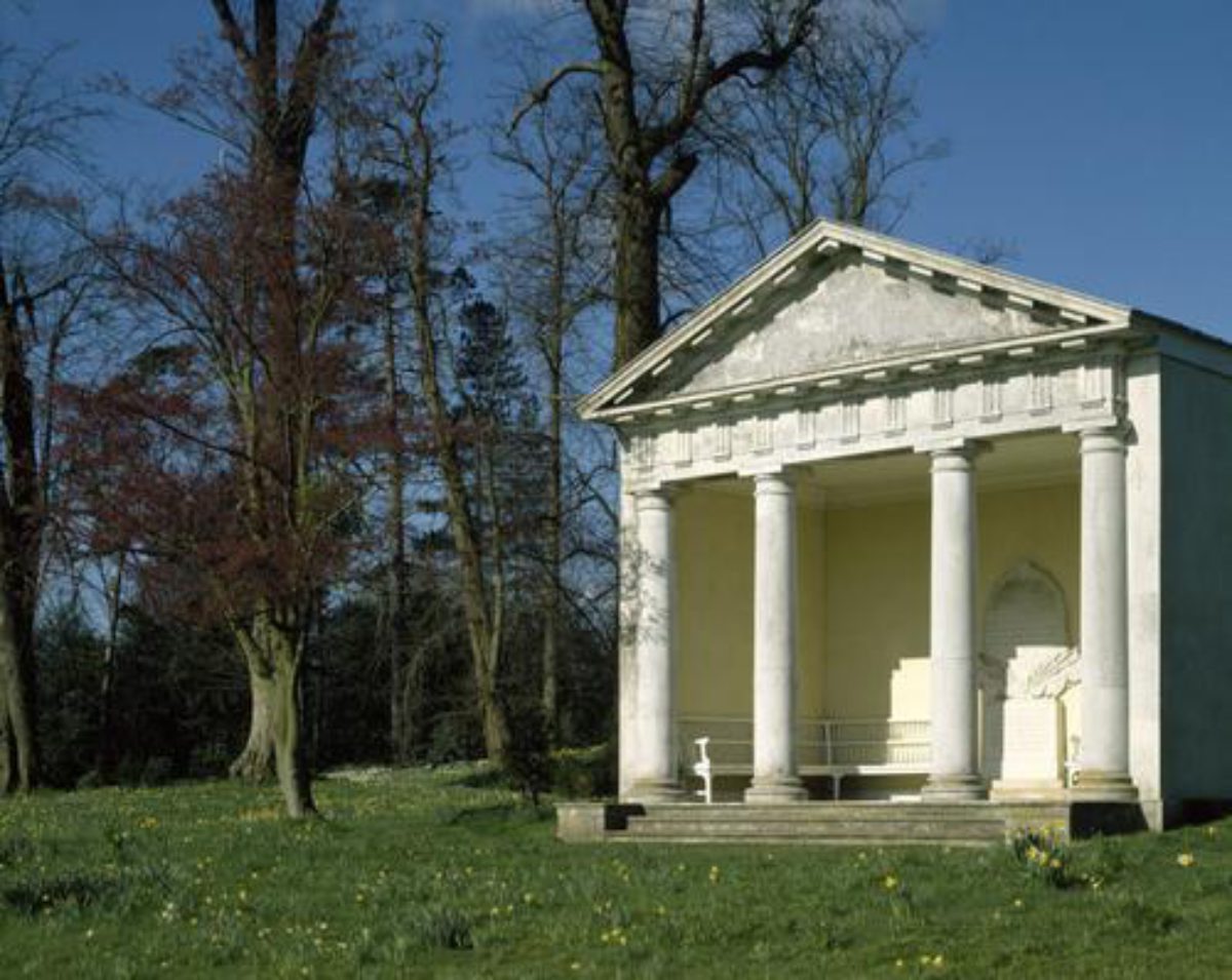
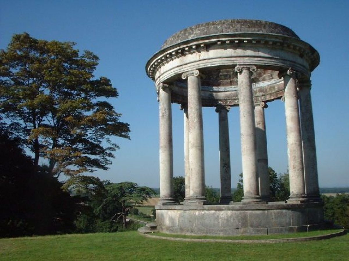
Northwards, beyond the line of a tunnel leading beneath the lawn from the park to the estate yards on the east boundary, the ground rises up a long gentle slope and is enclosed from the park along the western boundary by a stone ha-ha built in 1754 by Brown and planted along the top with an evergreen belt (restored after storm damage in 1987). Winding, gravelled paths lead through lawns dotted with trees of mixed ages and species (a few mature trees surviving from the mid C18 and others from informal planting of exotics in the C19). The west-central part of the grounds, also largely destroyed in the storm, was replanted in the early 1990s and will be managed to restore the deciduous, forestry-style plantation planting of the C17 (NT 1991). The site of the Pleasure Grounds, first shown on the survey plan of 1610 as a formal, rectangular plantation with 'Birchen Walks', was modified and adapted by London to form a bosquet with seats. Brown's plan retained its form but replaced its straight walks with serpentine paths planted with mixed flowering shrubs and trees (nursery lists survive at Petworth). A Doric temple (restored 1949, listed grade II), first shown on Brown's 1752 plan but formerly situated on the terraces, stands 220m north of the House while 220m further north is a roofless, Ionic rotunda (listed grade II), possibly designed by Matthew Brettingham (NT 1985). The path running north from the rotunda descends the slopes through extensive azaleas plantings of 1992 then leads into Tanners Croft, a Pinetum begun in 1981. These new plantings largely replace the rhododendrons established between 1870 and 1924.
PARK
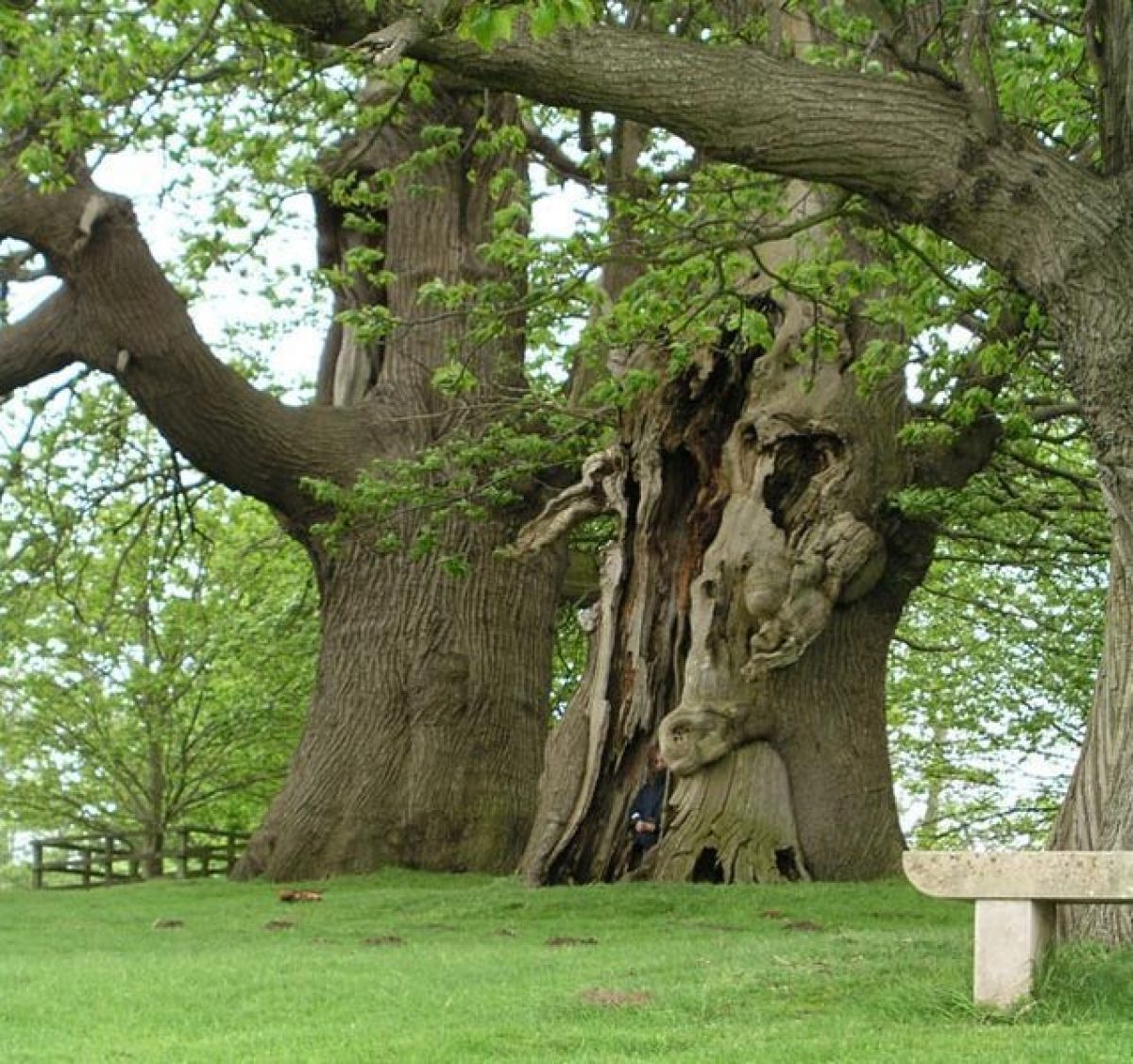
The park extends some 2.5km north-westwards from the House, the majority laid to permanent pasture grazed by deer and planted with clumps, belts and individual trees and with small areas of wood and plantation. Enclosure of areas of common land which roughly correspond to the present park was made in the C16.
The west front of the House opens onto a narrow terrace and a broad, open, 400m long lawn laid out in 1752-3 by Brown on the site of three rectangular compartments (outlines visible on aerial photos of 1968) extending westwards from the House which formed its formal setting from the late C17, the easternmost compartment containing the great stable block built in 1621 and demolished c 1725 (view of c 1680). To the north-west the lawn is enclosed by the steep slopes of Lawn Hill which rise to a summit crowned by clumps of trees of mixed ages and species, some surviving from the early C19 and badly damaged in the storm of 1987. Between 1610 and 1630 the slope of the Hill, which then extended further south over the lawn, was cut into a series of long terraces, shown, with the summit well wooded, in the view attributed to Knyff. The terraces were further developed in the C17 and early C18 before being converted in 1752-3 into '1 fine undulated hill Adorned with groups of cedars, pines &c' (Note 26 on Brown's plan), Brown partly utilising existing tree cover to form his layout. The present lawn, which Brown lowered, was further lowered by Thomas Upton in 1795-6. A C17 urn (listed grade II and one of several erected around the lake by the third Earl in the late C18) stands on the slope of Lawn Hill, some 120m north-west of the House. West of the lawn the valley floor is occupied by a c 6ha, serpentine, partly tree-fringed lake known as Upper Pond, which was designed and constructed by Brown in 1752-3 (1st contract, PHA) on the site of former fishponds. The lake contains a number of small islands (added after Brown's work) and, on the north-east shore, a stone boathouse featuring a large keystone with a Neptune relief, erected, with the statue of The Dog of Alcibiades (by Carew) standing in the eastern edge of the water, by the third Earl in the late C18 (boathouse and statue listed grade II).
South-west of the lawn, the western drive crosses the dam and runs north-westwards through open parkland dotted with mature trees and through belts and plantations of mixed ages and species (with extensive replanting following storm damage) on Snow Hill, the western boundary ridge and along the northern boundary to Half Moon Furze. In the north-west corner, adjacent to the park wall, is a castellated square tower built by the third Earl in 1816, probably to designs by Sir John Soane. Eastwards below the western ridge, the level plain of the park is open in character and dotted with a few loose clumps and individual trees. On its far eastern side is a further lake, Lower Pond, which was designed and planted by Brown in 1756-7 (4th contract, PHA).
KITCHEN GARDEN
The kitchen garden lies in the extreme south-east corner of the park. Its 150m square form is enclosed by high stone walls with entrances on the north side. It is divided into three compartments by east to west walls and is laid out to paddocks at the south end, hedged enclosures and a swimming pool in the centre and an ornamental Italian garden and vegetable area at the northern end. A walled enclosure, which was probably the kitchen garden at the time, is shown on the view of c 1680 attributed to Knyff, lying on the south side of the former south-western park boundary. It was probably also this garden which is recorded as enlarged in 1703 to 2.8ha and which is shown on the 1706 map as divided into three. By 1762, the new road had allowed the incorporation of the garden into the park and it underwent significant development by the third Earl. It supported a full range of glass, noted by Loudon in 1822. Shown on OS editions until the late 1930s, the glass has since gone.
REFERENCES
J C Loudon, An Encyclopaedia of Gardening ... (1822), p 1230
Country Life, 58 (28 November 1925), pp 818-26; (5 December 1925), pp 862-71; 153 (28 June 1973), pp 1870-4
I Nairn and N Pevsner, The Buildings of England: Sussex (1965), pp 301-7
D Stroud, Capability Brown (1975), pp 68-9, pl 9
J Harris, The Artist and the Country House (1979)
Petworth Park, guidebook, (National Trust 1985)
Petworth Park and Grounds, Historical Survey..., (National Trust 1988)
Petworth, Storm Damage 1990, Grant Aid Application to English Heritage, (National Trust 1990)
Petworth: Grant Aid application to EH, (National Trust 1991)
Petworth Park, (National Trust leaflet 1994)
Maps [All held in the Petworth House Archive.]
Ralph Treswell, survey dated 1610 (PHA 3574)
John Hutchinson, Lands of the Duke of Somerset between Petworth and Tillington ..., 1706 (PHA 3580)
John Hutchinson, A Plan of Part of the Ground on the North Side of the Vistoe ... Petworth, 1706 (PHA 3580)
Anon, An Ocular Draught of the Home Park ..., 1749
Anon A map of the Gardens and Park at Petworth, 1751
Lancelot Brown, design for Petworth park, 1752 (PHA 3588)
Crow, Survey of Petworth, 1779
H Thomas Upton, Plan of Petworth Parks, Paddocks &c, 1869
OS 6" to 1 mile:
1st edition surveyed 1874-5, published 1880
2nd edition published 1898
3rd edition published 1913
OS 25" to 1 mile:
1st edition surveyed 1875
3rd edition surveyed 1910
Illustrations
View of the old house and stables, attributed to J Knyff (in Harris 1979)
Archival items
The Petworth House Archive (PHA), which covers the full history of the estate to the present day, is held in a private collection. Brown's contracts are mostly catalogued under PHA 6623.
Description written: February 1998 Amended: January 2000
Register Inspector: VCH
Edited: June 2000
- Visitor Access, Directions & Contacts
Telephone
441798342207Access contact details
http://www.nationaltrust.org.uk/place-pages/260/pages/opening-times-calendar
Owners
The National Trust
Heelis, Kemble Drive, Swindon, SN2 2NA
- History
The following is from the Register of Parks and Gardens of Special Historic Interest. For the most up-to-date Register entry, please visit the The National Heritage List for England (NHLE):
www.historicengland.org.uk/listing/the-list
HISTORIC DEVELOPMENT
The manor of Petworth came into the Percy family in 1150 through a gift from Henry I's queen to her brother, on his marriage to Lady Agnes de Percy. The earldom of Northumberland was granted to the family in 1377, the ninth Earl probably being the creator of the elaborate Elizabethan gardens laid out around the house and on the site of the present pleasure grounds in the late C16. In 1682, the grand-daughter of the tenth Earl married Charles Seymour, sixth Duke of Somerset who, in 1688, began rebuilding Petworth House and who engaged George London to create formal gardens on its north side. The seventh Duke succeeded in 1748 and was granted the earldoms of Northumberland and Egremont but leaving no sons on his death, the titles and estates were divided, Petworth and the earldom of Egremont passing to his sister Catherine's son, Charles Wyndham, for whom Lancelot Brown (1716-83) drew up designs and carried out extensive works in the park and gardens between 1751 and 1763. His son, the third Earl, was a patron of progressive agriculture and the arts and a friend of J M W Turner who painted Petworth and its landscape. On his death, while the earldom passed to a nephew (and became extinct), the House and estate passed to his eldest son George Wyndham, who was created Baron Leconfield in 1859 and whose son employed Anthony Salvin in 1869 to make alterations to the House and grounds. In 1947, the third Lord Leconfield conveyed Petworth to the National Trust. His nephew, John Wyndham, was created Lord Egremont in 1963 and his son, the present Lord Egremont, retains close family ties with the estate. A small area of the registered site (near the House) remains (1998) in private ownership.
- Associated People
- Features & Designations
Designations
The National Heritage List for England: Register of Parks and Gardens
- Reference: GD1059
- Grade: I
Features
- Boundary Wall
- Description: The park is entirely enclosed by a high wall, some 8km in length, most of which was probably built from 1756-63.
- Earliest Date:
- Latest Date:
- Great House (featured building)
- Description: The house was re-built from 1688. Anthony Salvin made alterations to the house in 1869.
- Earliest Date:
- Planting
- Description: Woodland garden.
- Kitchen Garden
- Parkland
- Key Information
Type
Park
Purpose
Ornamental
Principal Building
Domestic / Residential
Survival
Extant
Hectares
294
Open to the public
Yes
Civil Parish
Petworth
- References
References
- {English Heritage Register of Parks and Gardens of Special Historic Interest}, (Swindon: English Heritage, 2008) [on CD-ROM] Historic England Register of Parks and Gardens of Special Historic Interest
- Stroud, D., {Capability Brown} (London: Faber, 1975), pp. 68-9, plate 9 Capability Brown
- Harris, J., {The Artist and the Country House} {London: Russell Chambers, 1979), pp. 192-3 The Artist and the Country House
- Nairn, I. and N. Pevsner, {The Buildings of England: Sussex} (Harmondsworth: Penguin Books, 1965), pp. 301-7 The Buildings of England: Sussex
- Colvin and Moggridge {Petworth: Historic Park restoration plan} (2004) Petworth: Historic Park restoration plan
- Rutherford, Sarah {Petworth Pleasure Ground Conservation Statement} (2008) Petworth Pleasure Ground Conservation Statement
- Related Documents
-
CLS 1/85/341
Hard copy
-
CLS 1/1193
extract from report: Lancelot Brown at Petworth 1751 -1763
anon - undated
-
CLS 1/1194
Analysis of Park History: coiloured plans numbered 2 to 5
anon - undated
-
CLS 1/85/341