

Introduction
Brocklesby Park is a landscape park containing lakes and woodland, with late-19th-century formal gardens around the house.
Terrain
The site lies on the chalk hills of the Lincolnshire Wolds and slopes northwards and westwards to the flat coastal plain around Immingham.The following is from the Register of Parks and Gardens of Special Historic Interest. For the most up-to-date Register entry, please visit The National Heritage List for England (NHLE):
A country house surrounded by early C20 formal gardens by Reginald Blomfield, set within a late C18 landscape park, lakes, and woodland for which Lancelot Brown, Thomas White, and Humphry Repton provided designs, with buildings by James Wyatt.
Location, Area, Boundaries, Landform and Setting
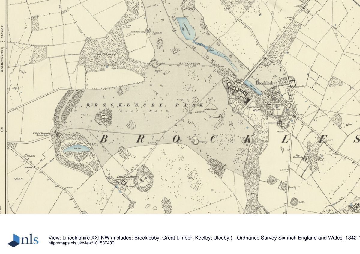
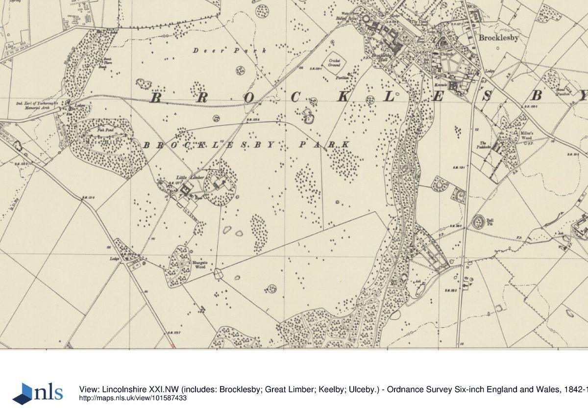
Brocklesby Park lies c 10.5km north of Caistor and c 15km east of Brigg in a rural part of north Lincolnshire, c 8km inland from the Humber estuary. The c 600ha site is composed of a large body of parkland with a sinuous woodland, cut through with rides, extending southwards for c 6.5km. The main park is partly bounded to the east and north-east by the B1211 Keelby to Ulceby road, with the land around Newsham lake surrounded by farmland. To the south the boundary is formed by Great Limber village, to the south-west by a minor country road, and to the north-west by farmland. The site lies on the chalk hills of the Lincolnshire Wolds and slopes northwards and westwards to the flat coastal plain around Immingham. There are several major views between garden buildings within the site, and from Newsham Lodge a long view over the lakes south-east towards the house.
Entrances and Approaches
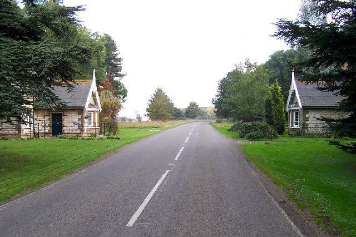
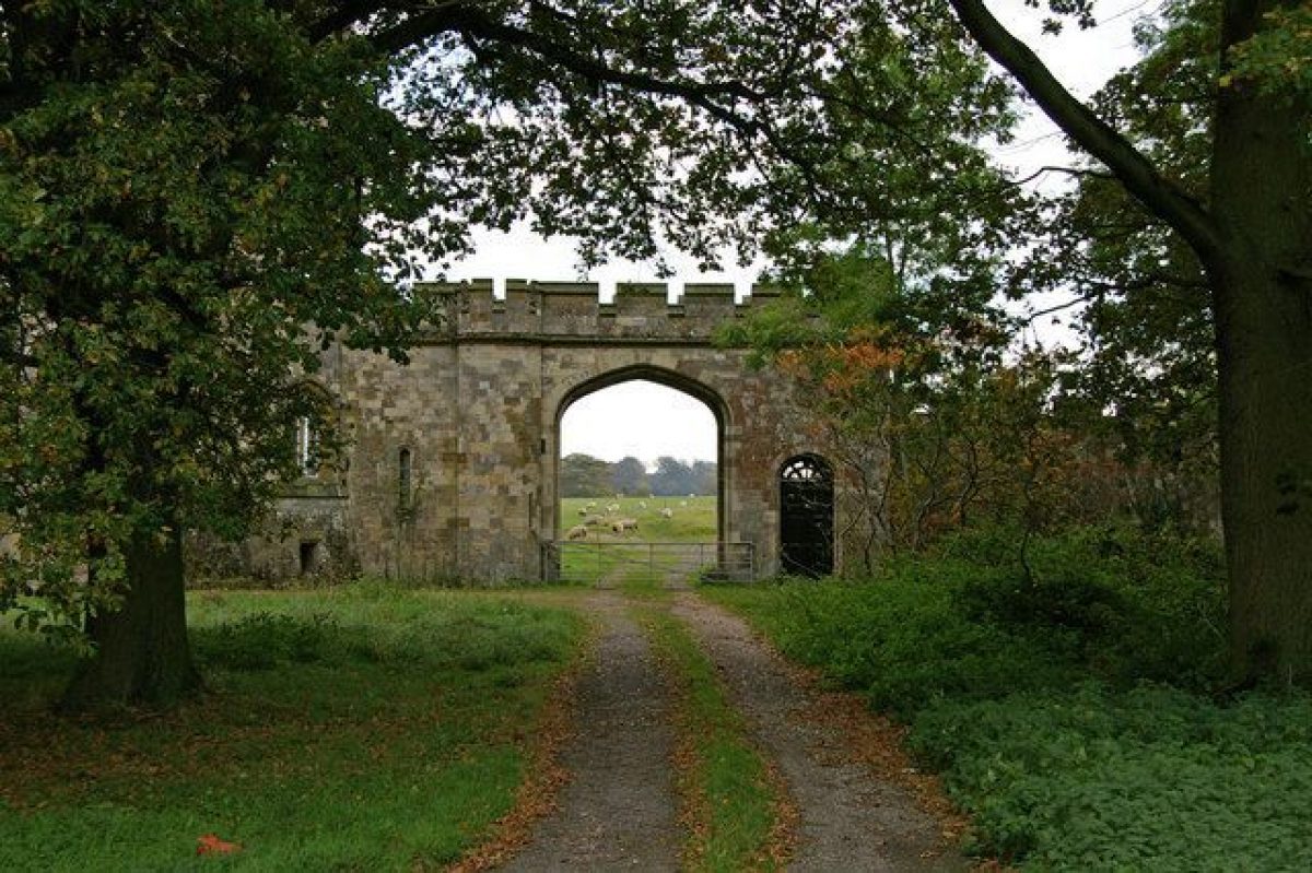
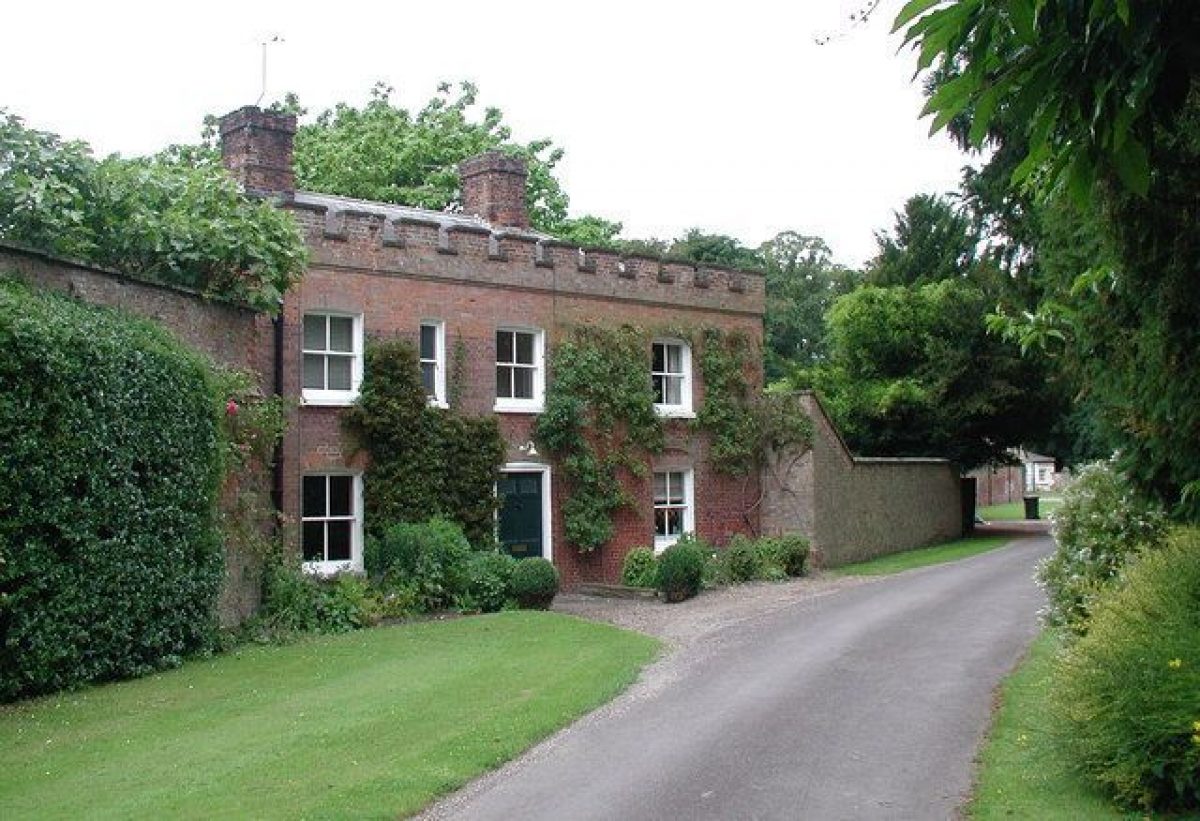
The present approaches to Brocklesby are off the B1210 which runs from west to east through the park. The entry of the B1210 into the park is marked on the western boundary entrance by the Memorial Arch (1864, listed grade II) set between a pair of lodges (1864, listed grade II). The road runs east, north-east, and then south-east to the house, bisecting the park. The road then continues north-east across the west end of The Canal to meet the B1211 c 0.5km north-east of the house. The drive turns off the road c 100m north-west of the house, passing between gate piers of yellow brick beside wrought-iron screen panels and the stables (late C18, possibly by James Wyatt, listed grade II*) to arrive at the north front of the house. Several other drives and lodges survive although these are no longer in use. The Great Limber Lodge (1789, listed grade II), built of yellow brick and slate, stands c 1.4km south-south-west of the house, beside gate piers and gates of ashlar and cast iron (late C18, listed grade II).
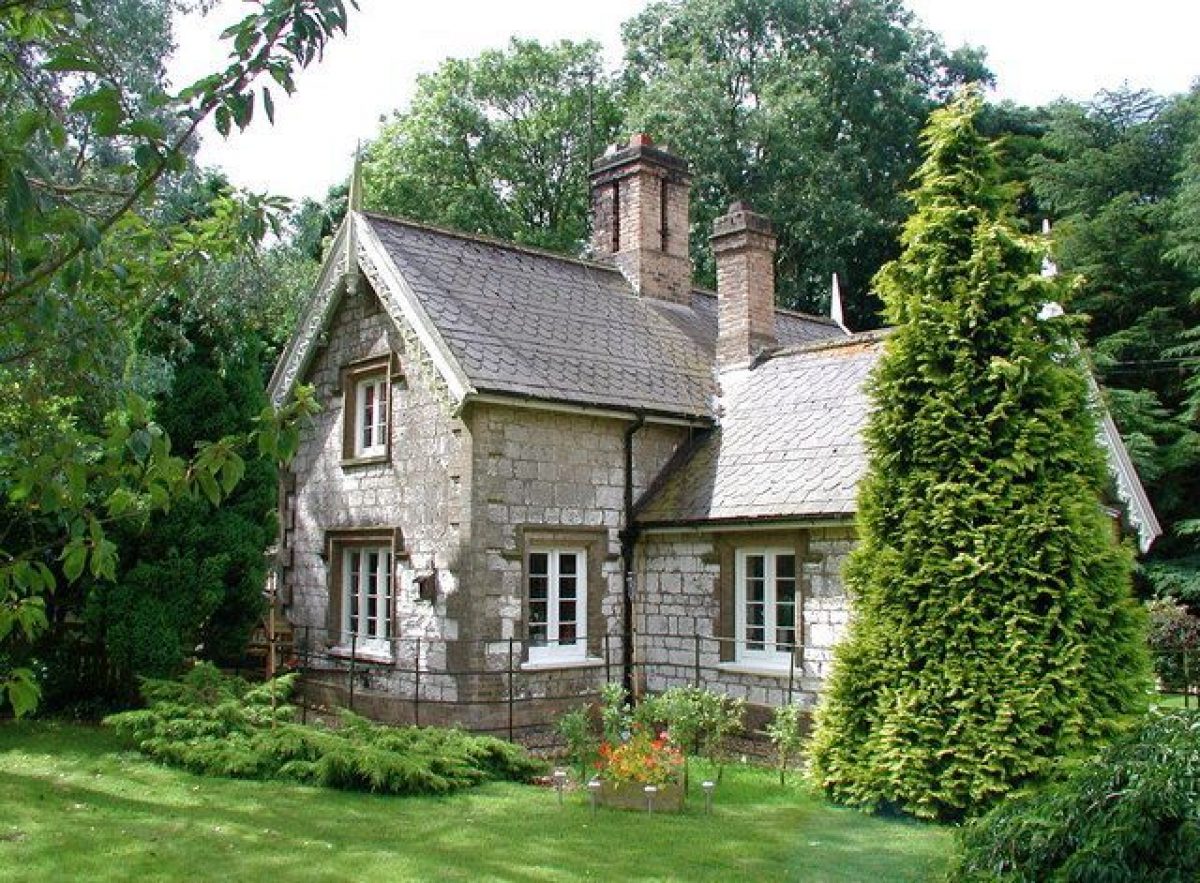
A serpentine circuit runs south from the pleasure grounds in front of the house through Mausoleum Woods, passing several temples and a grotto before reaching the Wyatt Mausoleum. Little Limber Lodge (early C19, listed grade II) lies c 1.2km south-west of the house, built of yellow brick with a pyramidal slate roof. The drive ran north-east through the village of Little Limber and then through open parkland to the south-east front. Newsham Lodge (early C19, possibly J Wyattville, listed grade II*) stands c 0.95km to the north-west of the house. East Lodge (late C18, listed grade II) marks the entrance to the pleasure grounds off the B1211, c 280m to the east of the house, the drive running west past North-East Lodge (C19, listed grade II) on the south side of the drive and Rectory Cottages (C19, listed grade II) on the north side.
Principal Building
Brocklesby Park (listed grade I) is a large country mansion set close to the north-east boundary of a large park. It is built of red brick with ashlar dressings in an L-shaped plan, the entrance lying on the south-west front and with garden fronts to the north-east and south-east. It was built in 1603 for Sir William Pelham and remodelled in 1710, at which time the entrance lay to the north-east. Additions were made by Lancelot Brown when the entrance was moved to the south. Following a fire in 1898 the hall was restored by Reginald Blomfield for the fourth Lord Yarborough. In 1957-8 Claud Phillimore was commissioned to reduce the size of the hall and move the entrance to the south-west front.
The early C18 pedimented stable range (listed grade II*) lies c 70m to the north-west of the house. It comprises a quadrangular court, in the centre of which is a clock turret that houses John Harrison's revolutionary clock (c 1722). Beyond the early C18 range, c 130m north-west of the house is a further C19 stable block (1866, listed grade II) built of brick with a hipped slate roof. Several buildings lie beyond the gardens east of the house: the church of All Saints (of C14 origin, listed grade I) c 200m to the east of the house, the late C18 estate office (listed grade II) c 310m to the south-east, and James Wyatt's Hunt Kennels and house (c 1796, listed grade I) which stand c 400m south-east of the house.
Gardens and Pleasure Grounds
The gardens lie north-east, south-east, and west of the house and are set within pleasure grounds marked on their south-west boundary by a ha-ha built under the direction of Lancelot Brown (estate archives).
Below the north-east front is a wide gravel terrace edged with a brick and ashlar revetment wall (late C18, listed grade II). Below this is a walled sunken garden, surmounted by balustrading and reached by flights of steps from the north-east terrace. This sunk garden was designed by Reginald Blomfield at the beginning of the C20, although the internal layout of the area which comprises a formal garden of gravel walks, yew hedges, pleached limes, and rose beds, is a late C20 addition. Beyond the sunk garden is a drive running alongside The Canal, a formal lake which existed prior to Lancelot Brown's work at Brocklesby in the late C18.
The south-east front of the house looks onto a long gravel balustraded terrace walk which leads south-west to the Conservatory (mid C19, listed grade II*). At the north-east end of the walk, below the house, the centre of the terrace has a semicircular bastion, either side of which paths edged with curved balustrades slope down to reunite in a long gravel walk. The walk is flanked by conical yews planted in lawns set with twin formal lily pools. Beyond the pools the path continues as a grass walk, flanked by formal clipped yew hedges that terminate at the Holgate Monument (James Wyatt 1785, listed grade I). At the south-west end of the upper terrace, beyond the conservatory, a yew hedge divides the walk and the bowling green below it from the west garden. The south-east garden was designed by Reginald Blomfield at the start of the C20 to make a grand formal approach to the now demolished wing of the house (CL 1934).
Informal lawns, walks, and shrubberies, first created by Lancelot Brown, lie to the west and north-west of the house. Within this area stands the ashlar and lead Orangery (early C19, listed grade II*) c 60m north-west of the house. It faces south-west onto a path flanked by lawns set with fountains, placed here during the mid C19 when the west garden was remodelled. The shrubbery in the north-west corner contains a C20 swimming pool and tennis court.
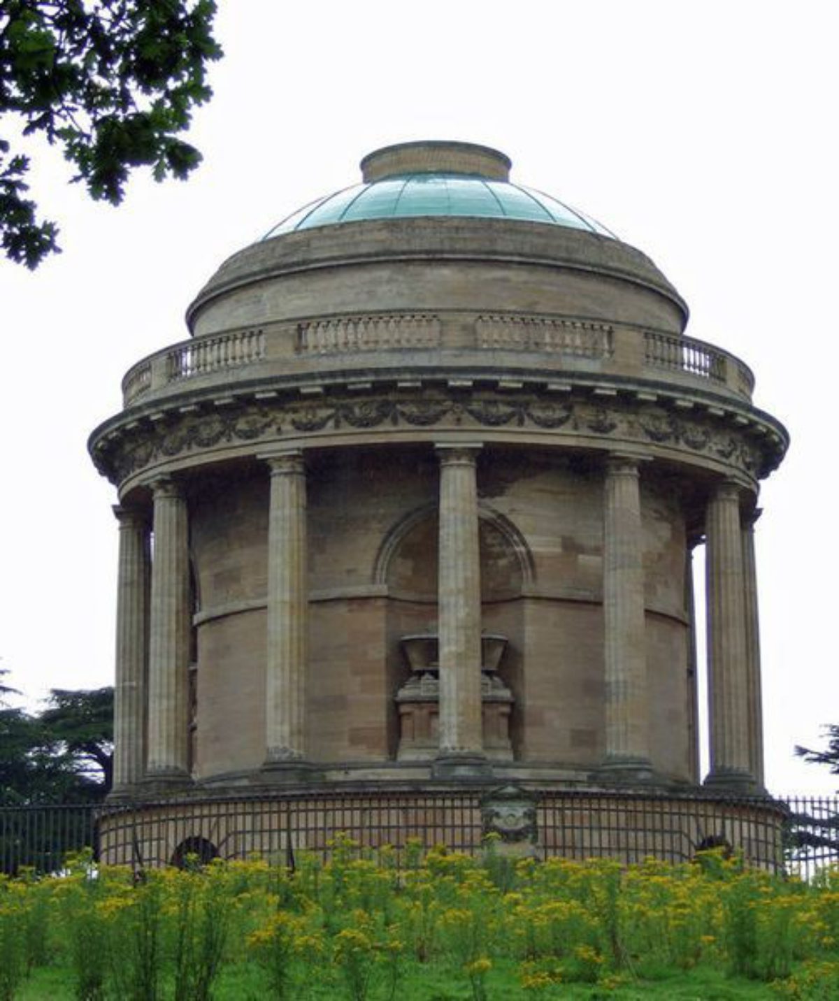
The pleasure grounds, which were created out of an earlier Wilderness in the late C18 and embellished throughout the C19, extend southwards from the south-east gardens and lead into Mausoleum Woods which bound the open park to the east. Both areas are cut through with paths and rides, along which stand a series of garden buildings: the classical ashlar and brick Mary Carter Temple (early C19, listed grade II) lies c 500m south-south-east of the house while 270m beyond this lies the red-brick, tufa, and wood Hermitage (late C18, listed grade I), standing by the red-brick, barrel-vaulted Grotto (late C18, listed grade II). The main ride continues south for a further 250m to the classical red-brick, ashlar, and slate Arabella Aufrere Temple (c 1787, possibly by James Wyatt, listed grade II*). Beyond this the path leads through the trees to the main body of Mausoleum Woods on the southern tip of the open park. Standing on high ground c 2.5km from the house is the Mausoleum (James Wyatt 1792, listed grade I), a fine ashlar building with a copper dome, facing north.
Park
The extensive park at Brocklesby is partly under grass and partly under arable, with few surviving individual parkland trees but scattered with many woodland blocks. A long chain of woodland extends beyond the open park to the south and south-west, at the southern tip of which, in Cabourne High Woods, stands Pelham's Pillar (E J Willson 1840-9, listed grade II), erected as an eyecatcher to mark the fourth Baron Yarborough's achievements in tree planting. In the north-east corner of the park, Lambert Hill Pond (c 0.5km north-west of the house) and Dam Bottom lake (c 300m north-west of the house) link together and flow into The Canal which lies below the sunk garden off the north-east front. Some 0.75km north of Lambert Hill Pond lies Newsham Lake beside the ruins of Newsham Abbey. This area, together with the bridge across the Lake, was laid out by Lancelot Brown in the 1770s (estate archives).
Little Limber village is located c 0.9km to the south-west of the house across open parkland, now (2001) mainly under arable production. The main park was first laid out by Lancelot Brown in 1771, at which time it extended as far as Little Limber on the parish boundary. Later in the century Thomas White prepared plans for extending the area, his undated (c 1780s) plans showing the boundary as it survives today. At the end of the C18 Humphry Repton made a Red Book for Brocklesby which was destroyed in the fire of 1898. The proposals it contained are therefore lost but mention of his work at Brocklesby in other publications suggest Repton was concerned with the creation of Lambert Hill Pond and Dam Bottom lake north-west of the house.
Kitchen Garden
The walled kitchen garden is situated c 350m south-east of the house and is divided into two compartments, the southern section being pentagon-shaped. The northern compartment contains C19 and C20 glasshouses including a vinery. The Gardener's Cottage (late C18, listed grade II) stands in the south-east corner of the garden and is built of red and yellow brick under a hipped slate roof. A pentagonal kitchen garden is shown in this position on Lancelot Brown's 1771 plan and estate accounts confirm that building commenced in 1773 (Ambler, quoted in Popham 1995). By 1908 the garden was divided into five parts by paths converging to a point in the centre (OS 1908).
Maps
- L Brown, A plan for the intended alteration ..., 1771 (reproduced in Stroud 1975))
- T White, Plan for the improvement of Brocklesby ..., c 1780 (reproduced in Stroud 1975)
- Estate map, 1834 (private collection) Estate map, 1853 (private collection)
- OS 6" to 1 mile:
- 1st edition surveyed 1886, published 1891
- 2nd edition published 1908
Archival items
- The extensive Brocklesby/Yarborough archive is housed partly at Lincolnshire Archives and partly in a private collection.
Description written: October 2000
Redrafted: May 2001 (EMP)
Register Inspector: CEB
Edited: May 2002
- Visitor Access, Directions & Contacts
Telephone
01469 560214Website
https://www.brocklesby.co.ukAccess contact details
The estate is in private ownership and holds a Country Fair, logs sales and has Holiday Lets.
- History
The following is from the Register of Parks and Gardens of Special Historic Interest. For the most up-to-date Register entry, please visit The National Heritage List for England (NHLE):
16th - 17th Century
The first recorded mention of a manor house at Brocklesby comes in 1585, following purchases of land made in the area by Sir William Pelham (d 1587) in 1564-5 and 1571 (Ambler, quoted in Popham 1995). Sir William's son, also Sir William (d 1629), built a new house at Brocklesby on a new site in c 1603 and surrounded it with 'fine gardens, groves and pleasure houses' (de la Pryme, quoted in Surtees Soc 1870).
18th Century
In c 1710, Sir William's descendant, Sir Charles Pelham, who inherited the Brocklesby estate in 1692, substantially remodelled the old Jacobean house in the Georgian style. His great nephew, Charles Anderson, inherited the estate from his uncle whilst still a minor, and following a visit to Europe on the Grand Tour, he returned to Brocklesby with his new wife, Sophia Aufrere and assumed the name Anderson Pelham. He commissioned Lancelot Brown (1716-83) in 1771 to make alterations to the house and to lay out new grounds and James Wyatt (1747-1813) to design complementary buildings, including a fine Mausoleum erected in 1786 following the sudden death of Sophia.
During the 1780s Thomas White (1736-1811) produced further plans to extend the park and at the end of the C18 Humphry Repton (1752-1818) prepared a Red Book (now lost) for Charles Anderson Pelham, who was created Baron Yarborough in 1794. Just before his death in 1823, Baron Yarborough, together with Jeffry Wyatville (1766-1840), conceived plans for a grand new mansion on a new site, but these were never implemented. Baron Yarborough was succeeded by his son, who was created Earl of Yarborough and Baron Worsley in 1837 and who carried on the woodland planting work started by his father. In 1845 the first Earl began alterations to the house which were completed by his son, Charles Anderson-Worsley who succeeded the following year.
19th Century
Both the second Earl and his son, also Charles, who succeeded in 1862, made several changes to the gardens around the house and in the late 1860s the house was again enlarged. The third Earl died in 1875 and his son Charles succeeded to the title when he came of age in 1880. Following a fire at the house in 1898, the fourth Earl, Charles commissioned Reginald Blomfield to restore it and to lay out new gardens.
20th Century
When the fourth Earl died in 1936 his second son, Sackville George Pelham, the fifth Earl inherited Brocklesby. Twelve years later, in 1948, the fifth Earl was succeeded by his brother, Marcus Herbert Pelham. The sixth Earl commissioned Claud Phillimore to reduce the size of the house which was returned to its early C18 size. John Edward Pelham, the son of Marcus, succeeded to Brocklesby in 1966 and continued to work on the famous estate woodlands. His son, Charles John became the eighth Earl on his father's death in 1991 and together with his wife laid out a new formal garden.
The site remains in private ownership.
Period
- 18th Century (1701 to 1800)
- Late 18th Century (1767 to 1800)
- Associated People
- Features & Designations
Designations
The National Heritage List for England: Register of Parks and Gardens
- Reference: GD1969
- Grade: I
Features
- Walk
- Lake
- House (featured building)
- Description: The house has been much re-modelled, having been both enlarged and reduced over 400 years.
- Earliest Date:
- Latest Date:
- Key Information
Type
Park
Purpose
Ornamental
Principal Building
Domestic / Residential
Period
18th Century (1701 to 1800)
Survival
Extant
Hectares
600
Civil Parish
Brocklesby
- References
References
- {English Heritage Register of Parks and Gardens of Special Historic Interest}, (Swindon: English Heritage, 2008) [on CD-ROM] Historic England Register of Parks and Gardens of Special Historic Interest
- Popham, John {Brocklesby Historic Landscape Management Plan Historic Buildings} (1995) Brocklesby Historic Landscape Management Plan Historic Buildings
- Popham, John {Brocklesby Heritage Management Plan Landscape Restoration Proposals} (1996) Brocklesby Heritage Management Plan Landscape Restoration Proposals
- Popham, John {Brocklesby Heritage Management Plan} (2004) Brocklesby Heritage Management Plan
- Popham, John {Heritage Management Plan Appendices 1 and 2} (2004) Brocklesby Heritage Management Plan Appendices 1 and 2
- Purcell Miller Triton {Brocklesby Buildings Survey} (2011) Brocklesby Buildings Survey
- Historic Land Management Services {Brocklesby Park Historic Landscape Survey} (2000) Brocklesby Park Historic Landscape Survey
- White, W., (1856), pp 659-60 Directory of Lincolnshire
- Surtees Society 24, (1870) 'The diary of Abraham de la Pryme: the Yorkshire antiquary'
- Vol 75, (24 February 1934), pp 192-8; (3 March 1934), pp 218-24; 78 (13 July 1935), p 31 Country Life
- Jones, B., (1974), pp 205-6 Follies & Grottoes
- Stroud, D., (1975), pp 160-1, 173, 218, pls 59a, 59b Capability Brown
- Pevsner, N, et al., (2nd edn 1989), pp 188-91 The Buildings of England: Lincolnshire
- Leach, T A., (1991), pp 122-50 Lincolnshire Country Houses and their Families II
- Robinson, D., (1999), p 26 Lincolnshire Bricks, history and gazetteer
- Turner, R., (1999), pp 65, 167, 175 Capability Brown and the C18 English landscape