Introduction
The site has the remains of a late-18th-century landscape park covering 83 hectares with 19th- and 20th-century development which at its most extensive was 140 hectares (345 acres). The site is now in divided use.
Terrain
The site lies on the crest and slopes of a high, open chalk ridge on the dip-slope of the North Downs, the land falling away on the east and west sides of the site and rising very slightly towards the southern boundary.The following is from the Register of Parks and Gardens of Special Historic Interest. For the most up-to-date Register entry, please visit The National Heritage List for England (NHLE):
Location, Area, Boundaries, Landform and Setting
An early C19 ornamental garden partly of late C18 origin and with mid to late C19 additions, set within an C18 and C19 park.
Belmont lies c 2km west of the A251, Faversham to Ashford road, some 0.5km to the north-west of Throwley village. The 83ha site, which comprises 5ha of formal and ornamental gardens set within 78ha of parkland and woodland, lies on the crest and slopes of a high, open chalk ridge on the dip-slope of the North Downs, the land falling away on the east and west sides of the site and rising very slightly towards the southern boundary. There are extensive views from the crest of the ridge to east and west along the line of the North Downs. The site is bounded to the west, south, and east by minor lanes and, except for a short length at the southern end of the east boundary, is largely screened from view by internal woodland or fringes of trees. To the north, the park abuts arable fields, orchards, and the wooded slopes and open fairways of a golf course while the whole estate is set within an undulating landscape of well-wooded arable and orchard land.
Entrances and Approaches
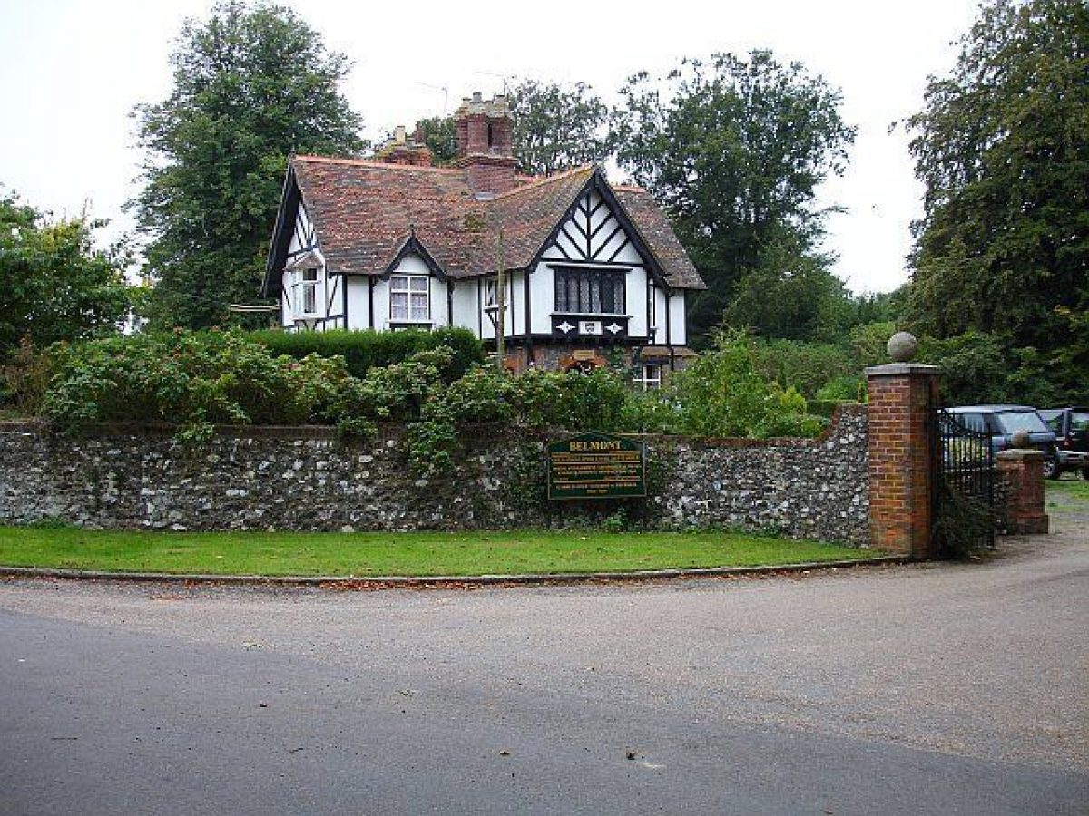
The entrance to the park is through a gateway at the south-east corner, beside a half-timbered lodge dated 1879. The principal drive, a former public road converted to a private park drive in c 1790 (guidebook), follows a north-westerly course before turning northwards to pass the west side of the house in a wide curve from which a spur extends eastwards into the stable yard and around to the south, entrance front of the house. Beyond the house, the drive continues northwards, now (1997) as a track and then a path, to meet the public lane beyond the north boundary of the site. This drive is shown established on Mudge's map of Kent of 1801, as is a former east drive, now grassed, which entered the park at the north-east corner and passed below the ha-ha on the east front of the house before looping north-westwards to cross the ha-ha and enter through a wrought-iron gate and screen to the south front forecourt. A further drive to the house, also now a grassed track and shown on Mudge's map, entered from Stalisfield Lane on the western boundary, beside New York Cottage (listed grade II) which was built in c 1790 in the American Colonial style by the architect John Plaw (c 1745-1820) as a pair of timber-framed cottages for the Belmont estate.
Principal Building
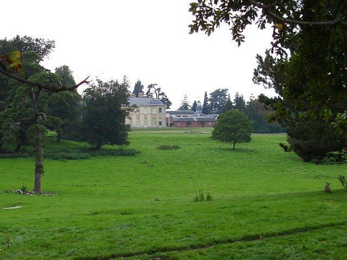
Belmont (listed, with the stables, grade I) stands on level ground in the centre of the park on the crest of a ridge and enjoys extensive views over the North Downs and north-eastwards to the Thames estuary. The main portion of the house, built for Colonel Montresor by Samuel Wyatt (1737-1807) from 1789 to 1793, sits partly on the site of and partly incorporates, buildings from a former house built by Edward Wilks in 1769. It is of two storeys, the principal, east front having nine bays, the outer six in two shallow bows with low, belvedere domes and glazed lanterns. Both the north and the south fronts incorporate a verandah on Ionic columns, with a single-storey orangery to the west of the south verandah. The whole house is faced in pale yellow mathematical tiles with the east front being decorated with Coade stone plaques. Adjoining the house to the north is a large, irregularly shaped stable courtyard, the west range and offices on the south side surviving from the 1769 house, the north range, designed by Samuel Wyatt, the east range and the two half-octagonal, yellow-brick lodges being added in the 1790s.
Gardens and Pleasure Grounds
The gardens and pleasure grounds surround the house in the form of a large oval, enclosed on the west side by the curve of the drive which is lined with a clipped holly hedge and occasional standard hollies. The east and south fronts of the house open onto a broad, semicircular lawn enclosed by a 1.2m high brick ha-ha wall which forms the east side of the oval. Inside the ha-ha, shown established on an estate plan of 1812, at points 110m north-east of and 25m south-east of the house, there are two sets of wrought-iron gates each with a short wing of fencing to either side (ha-ha and gates listed grade II). A few mature exotic trees, including plane, beech, and a tulip tree, survive from the fringe shown enclosing the south and east lawns in 1876 (OS), those on the south lawn now (1997) mixed with newly planted specimen trees. Between the south lawn and the principal approach drive, and extending northwards to the entrance to the stable yard, the grounds are laid out as a wooded shrubbery with mature native and exotic trees, including conifers, underplanted with yew and laurel in both natural and clipped forms. An estate sale plan of 1779 indicates shrubberies south of the house and trees are shown planted there on the 1812 estate plan. The present area of wooded shrubbery is shown established by the 1870s (OS 1876) while a laurel grove (not shown on either the estate plan of 1812 or the OS map of 1876), lying south of the house, is referred to in surviving family diaries of 1810-13.
North-west of the north range of the stables and enclosed by the clipped hedging along the main drive, is a pinetum, planted between 1812 (estate plan) and c 1870 (OS 1876). It is entered at the south end, through a wrought-iron gate beside the northern entrance lodge to the stable yard, which leads onto a lawn scattered with conifers of mixed species and age including late C20 planting. On the lawn some 20m west of the west wall of the stables is a sandstone grotto, its arched recess lined with flints and ammonites. At its north end the lawn terminates in a sandstone rockery planted with shrubs and small ornamental trees. Immediately north of the north range of the stables, between the pinetum and the east front lawn, high red-brick walls (listed grade II) enclose a rectangular 70m x 38m formal garden, shown established on the estate plan of 1812 as two, north and south, courtyards. The present single, walled rectangle, shown on the OS map of 1876, consists of lawns edged with herbaceous borders with a rectangular lily pool, recorded as a fountain on the 3rd edition OS map, as the focus at the north end of the lawn and a tazza on a plinth at the south end. Three archways in the west wall, which has a pump (listed grade I) on its west side, form entrances to the formal garden from the pinetum. A glasshouse against the north wall shown on OS 25" maps between 1876 and 1939 has now (1997) gone.
Park
The parkland surrounds the house and gardens on all sides. To north and south on the central plateau and on the gentle eastern slopes below the house it is fairly open in character, almost entirely laid to permanent pasture and dotted with clumps and individual trees of mixed age and species. Some 160m south-east of the house remnants of a short avenue of oak and chestnut which connected the present main drive with the drive from the north-east (shown on Greenwood's map of 1819-20) forms a linear plantation, at the north end of which is a grassed icehouse mound with a flint-faced entrance wall. To the north-east of the house, the scatter of trees is of greater variety, with several exotics such as Wellingtonia and acacia mixed with chestnut, oak, and lime. North of the formal gardens, a chestnut-lined drive leading north to Little Belmont (just outside the site boundary) passes Park House and remnants of an orchard shown in existence in 1871 (OS 1876). Northwards again the drive passes the eastern edge of the open grassed site of the former cricket field, laid out by the fourth Lord Harris in 1870 and in use until the 1950s.
West of the house the grassed plateau contains only a sparse scatter of individual trees. Beyond, on the steep upper slopes which fall towards Stalisfield Road on the western boundary is the site of a former beech hanger, planted c 1780 (ring counts) and destroyed in the storm of 1987. West and north-west of the hanger site are mixed plantations, planted as game cover in the C19, extended southwards in the C20 (OS 1908), and extensively replanted after the 1987 storm.
The OS drawing of 1801 shows a small park at Belmont to the east of the house containing fenced tree clumps and surrounded by fields. By 1819-20, Greenwood's map shows the park extending west of the house to the edge of the beech hanger and northwards to the present boundary. The area in the south-west corner, between the principal drive and New York Cottage, which has its steep west-facing slopes planted with two lines of beech pollards. By 1871 (OS 1876) the parkland had been extended north of the present boundary as far as Deadman's and Wilderton Woods. In C20, this area was turned over to farming and forestry and part of it was developed in the 1920s as the present (1997) golf course.
Kitchen Garden
The kitchen garden lies immediately to the north-west of the ornamental gardens. Built by General Harris from 1805 to 1808 and shown on the estate plan of 1812 (Haslam 1995), it is roughly triangular in shape. The garden, which covers an area of c 0.5ha, is enclosed by red-brick walls with glasshouses built against the internal south-west-facing wall; it is at present (1997) in an uncultivated state. Further fenced enclosures, laid out to soft fruit and, on the south side, flower borders and nut trees, surround the garden.
Maps
- Estate sale plan, 1779 (private collection)
- W Mudge, Map of Kent, 1" to 1 mile, 1801
- Estate map, c 1802-03 (private collection)
- Estate map, 1812 (private collection)
- C Greenwood, Map of the County of Kent from an actual survey made in the years 1819 and 1820, c 1" to 1 mile, 1821
- OS Surveyor's drawing, 2" to 1 mile, 1801 (British Library Maps)
- OS 6" to 1 mile:
- 1st edition surveyed 1866-71, published 1876
- 2nd edition published 1898
- 3rd edition published 1908
- OS 25" to 1 mile:
- 1st edition surveyed 1871, published 1876
- 2nd edition published 1898
- 3rd edition published 1907
Archival items
- Family Diaries (private collection) [quoted in Haslam 1995]
Description written: October 1997
Register Inspector: VCH
Edited: November 2003, January 2023
- Visitor Access, Directions & Contacts
Website
https://belmont-house.org/Access contact details
The Gardens are open daily through the year, including Bank Holidays, from 10am until 6pm (dusk if earlier).
The House is open from 3rd April to 27th September.
For more detailed visitor information visit the Belmont House & Gardens website.
Directions
The route to the estate is sign posted from the A251.
For more detailed directions please visit the Belmont House & Gardens website.
- History
The following is from the Register of Parks and Gardens of Special Historic Interest. For the most up-to-date Register entry, please visit The National Heritage List for England (NHLE):
18th - 19th Century
The land occupied by Belmont was bought from the Sondes family in the mid C18 by Edward Wilks, the store-keeper of the Royal Powdermills at Faversham, who built the first house on the site. It was sold in 1780 to Colonel Montresor of the Royal Engineers who enlarged the estate and built the present house. Mistakenly accused of embezzling army funds, his estate was sequestered by the government and sold at auction in 1801 to General George Harris, ennobled in 1815 as the first Lord Harris, for military service in India.
20th Century
The estate remained in the private ownership of the Harris family until the early 1980s when the fifth Lord Harris set up the present (1997) independent charitable trust to secure the preservation of Belmont.
Period
- 18th Century (1701 to 1800)
- Late 18th Century (1767 to 1800)
- Associated People
- Features & Designations
Designations
The National Heritage List for England: Register of Parks and Gardens
- Reference: GD1224
- Grade: II
Features
- House (featured building)
- Earliest Date:
- Kitchen Garden
- Sundial
- Greenhouse
- Icehouse
- Description: Grassed icehouse mound with a flint-faced entrance wall.
- Lilly Pond
- Description: Rectangular Lily pool located in the gardens.
- Stables
- Grotto
- Description: Sandstone grotto
- Ha-ha
- Description: 1.2m high brick ha-ha
- Lodge
- Description: Two half-octagonal, yellow-brick lodges being added in the 1790s.
- Cottage
- Description: Timber-framed cottages - John Plaw (c 1745-1820).
- Key Information
Type
Park
Purpose
Ornamental
Principal Building
Domestic / Residential
Period
18th Century (1701 to 1800)
Survival
Extant
Hectares
83
Open to the public
Yes
Civil Parish
Throwley
- References
References
- {English Heritage Register of Parks and Gardens of Special Historic Interest}, (Swindon: English Heritage, 2008) [on CD-ROM] Historic England Register of Parks and Gardens of Special Historic Interest
- Newman, J. {The Buildings of England: West Kent and the Weald} (London: Yale University Press, 1976) p. 134-5 The Buildings of England: West Kent and The Weald
- Colson Stone Partnership {Historic Landscape Survey & Restoration Masterplan} Historic Landscape Survey & Restoration Masterplan
- Hasted, E., (1797-1801) [Facsimile edn 1972], p 447 The History and Topographical Survey of the County of Kent, Vol. 2
- Vol 117, (27 January 1955), pp 246-9; (3 February 1955), pp 318-21 Country Life
- Phibbs, J., (HBAC Gardens Sub-committee report 1988) Belmont Park
- Haslam, C., (Landmark Trust c 1995) Belmont, guidebook, (Belmont 1997) The Prospect Tower (Belmont Guidebook)