Introduction
A mid-C19 cemetery laid out for a commercial company by an unidentified architect. The site is roughly triangular in plan, and occupies about 6 hectares of undulating ground. Features include both an Anglican and Nonconformist chapel, a gate lodge, mortuary, several specimen trees and listed tombs and monuments.
Terrain
The cemetery is laid out on undulating ground which rises to its highest point adjacent to the Anglican chapel. To the west, south, and north the ground falls away sharply towards the boundaries.The following is from the Register of Parks and Gardens of Special Historic Interest. For the most up-to-date Register entry, please visit The National Heritage List for England (NHLE):
Location, Area, Boundaries, Landform and Setting
Barton Road Cemetery is situated c 1km north-west of the centre of Torquay, to the south of the B3199 Hele Road. The c 6ha site is approximately triangular on plan, and is enclosed by rubble-stone walls c 2.5m high. To the north the site is bounded by the B3199 Hele Road, while to the east it adjoins Barton Road. To the south-west it adjoins a late-C20 industrial and commercial estate. The cemetery is laid out on undulating ground which rises to its highest point adjacent to the Anglican chapel.
To the west, south, and north the ground falls away sharply towards the boundaries, allowing extensive views west across surrounding residential and commercial developments, the mid and late-C20 buildings of Torbay Hospital on rising ground to the west, and woodland at Shiphay. There are more distant views towards Dartmoor. In the C19 the cemetery was situated outside the developed area of Torquay and was surrounded by agricultural land and land developed for brickworks and potteries, while to the south there were areas of open ground including Torquay Cricket Ground, Chapel Hill Pleasure Grounds, and Stanway Hill which formed a link with the town (OS 1890).
Entrances and Approaches
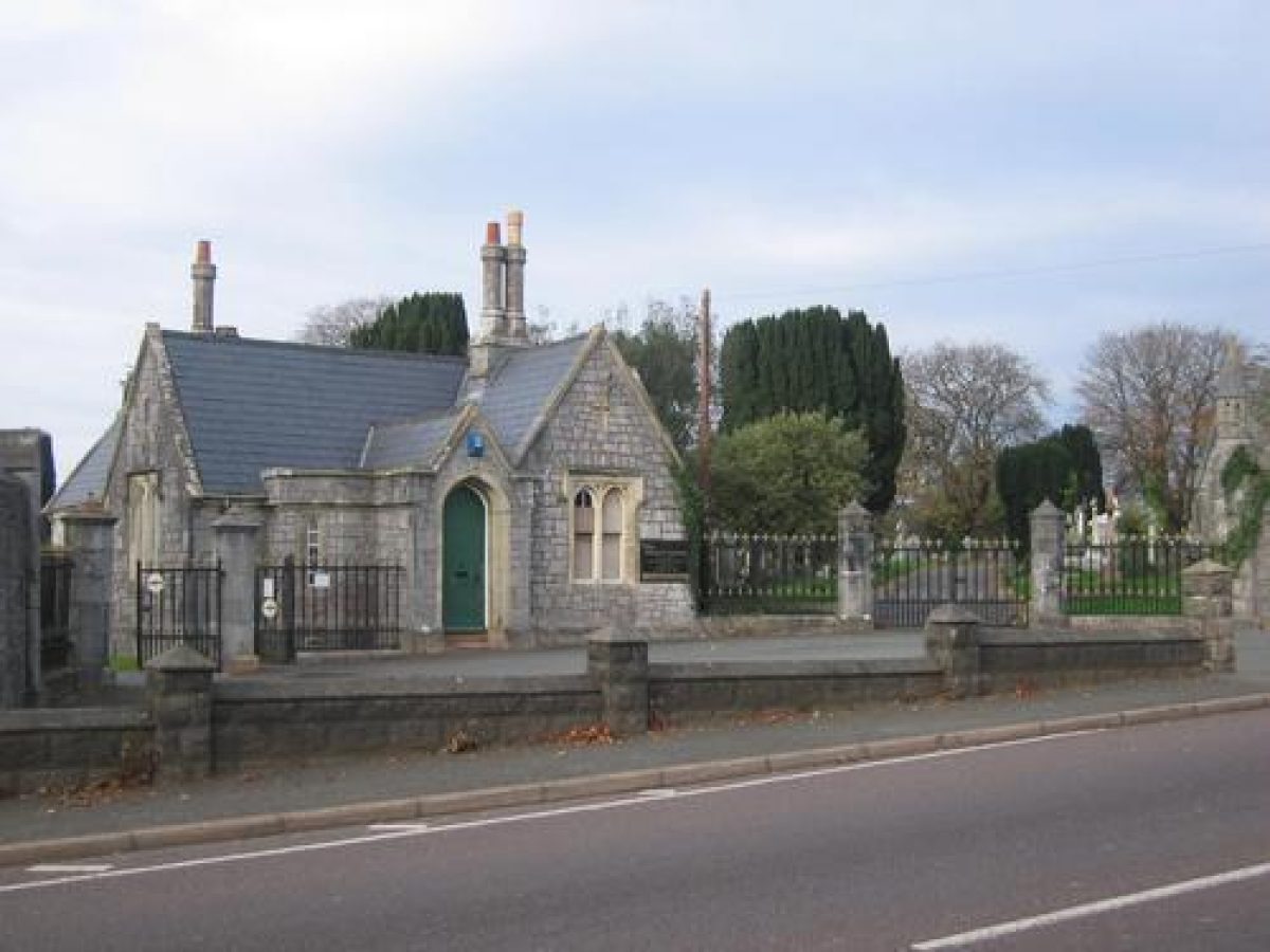
Barton Road Cemetery is entered from Barton Road to the east at a point c 100m south-south-west of its junction with the B3199 Hele Road at Hele Cross. The entrance comprises a pair of high stone quadrant walls in each of which is set a gothic-arched green-painted timber door with ornamental iron hinges. The quadrant walls screen single-storey stores or toilets. The line of the quadrant walls is continued by ornamental cast-iron railings with cross finials which terminate in octagonal-section stone piers supporting cast-iron carriage gates of similar design to the railings.
A single-storey stone lodge in Tudor Gothic style is placed on the central axis of the entrance. The quadrant walls, railings, gates, and lodge are of mid-C19 construction and are all listed grade II. A carriage turn east of the lodge is separated from the road by a low rusticated concrete wall of C20 construction. From each pair of carriage gates a tarmac drive follows a curving course either north-west to reach the Anglican chapel, or south-west to arrive at the Nonconformist chapel.
There is a further entrance to the cemetery from the B3199 Hele Road to the north-north-west at a point opposite the entrance to the C20 cemetery and crematorium north-west of Hele Road, c 100m west-south-west of Hele Cross. This entrance comprises a pair of cast-iron carriage gates with spear-headed finials, supported to the north-east by a square stone pier and to the south-west by a cast-iron pier; to the south-west the carriage gates are adjoined by a single pedestrian gate of similar design which is supported to the south-west by a square stone pier. This entrance is first shown on the OS map of 1904 and is probably contemporary with the early-C20 cemetery extension.
Principal Building
The two chapels are placed on the crest of the north-west-facing slope overlooking the lower sections of the cemetery. Each forms a focal point in views from the Barton Road entrance to the site, while the northern or Anglican chapel is a significant feature in views from the Hele Road entrance and walks in the lower areas of the site to the north-west. The Nonconformist chapel is particularly prominent in views from the south. The Anglican chapel (listed grade II) is situated c 100m north-west of the Barton Road entrance. Of buttressed stone construction with Bath stone dressings and a pitched slate roof, the chapel is built in Decorated Gothic style with an arched doorway in the south-west façade and a gabled porch on the south façade adjacent to a slender octagonal turret which rises to a louvered belfry surmounted by a short spire. The chapel is now (2001) disused. It was constructed to the designs of an unidentified architect c 1855 (Ellis 1930).
The Nonconformist chapel stands c 90m south-west of the Barton Road entrance and is similarly constructed in stone under a pitched slate roof. This chapel is of simpler design with less ornament than the Anglican chapel, and no spire. The chapel is entered through an arched doorway in the south façade, and is lit by simple Gothic-style windows. The Nonconformist chapel was built in 1862 to the designs of an unidentified architect (ibid).
Other Land
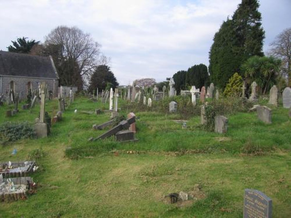
Torquay Cemetery is laid out in a series of burial areas divided by drives and tarmac walks. The burial areas on the higher ground adjacent to the chapels and Barton Road entrance are irregular in plan and are planted with a variety of specimen trees, conifers, and Torbay palms (Cordyline). There is further ornamental planting adjacent to the Barton Road boundary to the north-east, and in a broad belt extending south-south-west from the Anglican chapel towards the Nonconformist chapel. The lower areas of the cemetery to the west and south of the chapels are laid out to a grid pattern with large mature Irish yews arranged in pairs along the principal walks.
To the north-west of the lodge a low rubble-stone wall extends c 130m to intersect a straight walk leading south-west from the Hele Road entrance. This wall retains a grass bank on its northern side, thus rendering it invisible from the northern or Anglican section of the cemetery. The wall and bank is the remnant of the physical barrier between the consecrated and unconsecrated portions of the cemetery which was demanded by Bishop Phillpotts in 1855 asa pre-condition for consecration (ibid). The wall formerly extended c 50m north-west of the walk leading to the Hele Road entrance, to reach the western boundary of the mid-C19 cemetery; this section of wall does not survive above ground (2001).
From the northern carriage gates at the Barton Road entrance a broad drive sweeps north-west to reach the Anglican chapel. This drive is lined on each side by significant C19 and early-C20 monuments, including c 20m south of the chapel a monumental white marble sarcophagus (listed grade II) commemorating Isaac Merritt Singer (d 1875) of Oldway Mansion, Paignton (qv). The Renaissance-style sarcophagus is ornamented with carved passion flowers, grapes, and other plants of symbolic significance; the corner buttresses are carved with maize plants, indicating Singer's American origins. The monument is set within area enclosed by a kerb of grey granite and chains suspended from granite bollards. In addition to the founder of the Singer Sewing Machine Company, the monument, constructed by the Monumental Company, Kensal Green, London (inscription), commemorates other members of the family including his daughter, the Princesse Edmond de Polignac (d1943), doyen of an influential artistic Salon in pre-war Paris, and her husband, the composer Prince Edmond de Polignac (d 1901).
To the south of the Singer monument stands a tall tapering classical white marble monument (listed grade II) in memory of Robert Aspland Marrillier, Deputy Lieutenant of the North Riding (d 1903). A life-sized naturalistic figure of a seated mourning woman holding a wreath of flowers is placed at the base of the monument. To the north-west of the Singer monument a broken column of grey granite decorated with a wreath of lilies, passion flowers, and foliage commemorates Frederick Boyer (d 1887).
A broad tarmac carriage turn surrounds the Anglican chapel, with walks descending north to the northern corner of the site, and west to a straight formal walk which leads to the Hele Road entrance. A further walk aligned on the east façade of the chapel is lined with mixed ornamental planting and a further group of significant monuments including, to the north, a tall, pedimented white marble Renaissance-style monument (listed grade II) ornamented with a relief of the Madonna and child inspired by della Robbia, which commemorates Kitty, Baroness de Reede de Ter (d1896).
To the south of the walk a white marble figure of the Good Shepherd in memory of James Claude Young (d 1904) is signed by J Nesfield Forsyth of London and dated 1906 (inscription). The walk aligned on the chapel leads c 50m east to join a walk which extends along the eastern boundary of the site. This walk is bordered by mature conifers including Deodar cedars and other ornamental planting, although the area of this planting is reduced in extent from the late-C19 (OS 1891) by C20 burials. To the west of this walk, c 80m north-east of the Anglican chapel, a group of significant monuments includes a white marble baldachino commemorating Lizzie Davies (d 1907), a tall white marble Celtic cross in memory of Jane Golding-Bird (d 1904), and a gothic tabernacle constructed in buff and green terracotta commemorating Frederick Thrupp (d 1895). The boundary walk descends to the corner of the site adjacent to Hele Cross and returns around the north-west boundary for c 100m to reach the Hele Road entrance. From the northern corner of the site a straight walk ascends the north-facing slope to return to the Anglican chapel.
From the Hele Road entrance a straight formal walk extends c 270m south-west to reach the southern boundary walk. The walk extending from the Hele Road entrance forms a vista aligned on woodland at Shiphay to the south-west. The walk is flanked by wide grass verges on which are set late-C19 and C20 monuments; beyond, on each side, is a belt of mixed ornamental planting including specimen hollies, Irish yews, and pines.
At the Barton Road entrance the southern pair of carriage gates leads to a broad tarmac drive which sweeps south-west to reach the Nonconformist chapel. To the north this drive is bordered by an open grassy area which has been developed in the late C20 as a children's burial ground. To the north-east of the chapel a granite chest tomb commemorating Elizabeth Jenkins (d 1907) is ornamented on its southern end with a bronze relief portrait by her son, the sculptor Frank Lynn Jenkins (d 1927), who is also commemorated in the inscription. Other monuments around the chapel are not of individual significance, and are set among scattered specimen trees and Torbay palms.
There are wide views from the chapel south-west towards Torbay Hospital and Shiphay. From the Barton Road entrance a walk leads south, parallel to the eastern boundary wall, passing after c 20m a mid-C19 stone and slate Gothic-style mortuary. The walk extends c130m south before turning west-north-west and leading c 130m to reach the southern end of the formal walk which leads from the Hele Road entrance. The walk is planted with widely spaced pairs of mature Irish yews, while the south- and south-west-facing slopes above it are planted with mixed mature specimen trees including copper beech and pines. Beyond this junction, the southern boundary walk turns north-west and, after a further c 90m, reaches the early-C20 cemetery extension.
Near the boundary between the C19 cemetery and the extension is a group of First World War Commonwealth War Graves Commission headstones, including a group commemorating servicemen from New Zealand and two larger memorials in the form of stone crosses. The extension comprises a triangular-shaped plot bounded to the north-west by a high stone wall separating it from Hele Road. It is laid out to a simple grid pattern with little ornamental planting.
Barton Road Cemetery retains the C19 path pattern, structures, and planting shown on the 1891 OS map; it also has a good representative collection of C19 and early-C20 funerary monuments.
Maps
- OS 6" to 1 mile: 1st edition surveyed 1862-88, published 1891; 2nd edition published 1906
- OS 25" to 1 mile: 1st edition surveyed 1888, published 1890; 2nd edition published 1906
Reasons For Designation
Barton Road Cemetery is designated at Grade II for the following principal reasons:
- Barton Road Cemetery is a High Victorian garden cemetery (1852) established by a commercial company to serve the resort of Torquay.
- The layout of the cemetery survives intact, together with its contemporary associated structures.
- The cemetery retains original planting, and the layout skilfully exploits the undulating topography for picturesque effect.
- The cemetery contains a good collection of C19 funerary monuments which reflect the social and economic development of Torquay during the C19 and early-C20.
Description written: October 2001
Edited: May 2002, December 2009, March 2022
- Visitor Access, Directions & Contacts
Access contact details
This is a municipal site for general public use.
Owners
Torbay Council
Town Hall, Castle Circus, Torquay, TQ1 3DS
- History
The following is from the Register of Parks and Gardens of Special Historic Interest. For the most up-to-date Register entry, please visit The National Heritage List for England (NHLE):
19th Century
As the resort of Torquay developed in the early-C19, so the existing burial grounds attached to the parish churches at Torre and Upton rapidly became overcrowded. Additions were made to Torre churchyard in 1836 and 1842, but still proved insufficient, while in February 1850 residents petitioned for a prohibition on intramural burials at Upton (Ellis 1930).
In 1851 the Torquay Extra Mural Cemetery Company issued a prospectus seeking to raise capital of £8000 in £10 shares. Despite having prominent local backers and directors, the Vestry was opposed to the Company's proposal and sought to petition Parliament to prevent the passage of the Company's Act of Incorporation. At the same time, in November 1851, the Local Board was petitioned to provide a public burial ground. Despite this opposition, on 30 June 1852 the Company received Royal Assent to its incorporation. The Company purchased a site comprising c 16 acres (c 6ha) on high ground outside the town and proceeded to lay out its cemetery in 1852-3. The first interment took place in the Nonconformist section in November 1852.
The realisation of the Company's scheme led its local opponents to petition the Bishop of Exeter, Dr Henry Philpotts, to consecrate a section for the use of the Established Church in October 1853. Dr Phillpotts however, a High Churchman, considered it contrary to Canon Law to consecrate any Anglican burial ground unless it was physically separated from any adjoining burial ground by a wall. While the first interment in the Anglican section took place in June 1854, the Bishop's objection led to a delay in consecration until the completion of a boundary wall in October 1855 (ibid). At the same time a chapel was constructed and consecrated for the use of Anglicans. A chapel for the use of Nonconformists was built in 1862 (ibid).
The cemetery was extended in 1869, and again in 1921, when land to the north-west of the original site was appropriated for burials; these areas were not divided by physical barriers into consecrated and unconsecrated sections.
20th Century
In April 1929 the Torquay Extra Mural Cemetery Company acquired a further area of ground to the north of Hele Road from the Cary Estate (outside the area here registered), on which a crematorium was built in the mid-C20. Torquay Cemetery remained the property of the Extra Mural Cemetery Company until c 1975 when its management was taken over by Torbay Council; the site remains municipal property today (2022). The records of the Company do not appear to have survived.
Period
- Post Medieval (1540 to 1901)
- Victorian (1837-1901)
- Features & Designations
Designations
The National Heritage List for England: Register of Parks and Gardens
- Reference: 5038
- Grade: II
Features
- Boundary Wall
- Description: The Bishop of Exeter, Dr Henry Philpotts, considered it contrary to Canon Law to consecrate any Anglican burial ground unless it was physically separated from any adjoining burial ground by a wall. This wall was completed in 1855.
- Earliest Date:
- Latest Date:
- Chapel
- Description: The Nonconformist chapel is similarly constructed in stone under a pitched slate roof. This chapel is of simpler design with less ornament than the Anglican chapel, and no spire.
- Earliest Date:
- Latest Date:
- Entrance
- Description: The entrance comprises a pair of high stone quadrant walls in each of which is set a gothic-arched green-painted timber door with ornamental iron hinges.
- Earliest Date:
- Latest Date:
- Railings
- Description: Ornamental cast-iron railings with cross finials.
- Earliest Date:
- Latest Date:
- Gate Piers
- Description: Octagonal-section stone piers.
- Earliest Date:
- Latest Date:
- Gate
- Description: Cast-iron carriage gates of similar design to the railings.
- Earliest Date:
- Latest Date:
- Gate Lodge
- Description: A single-storey stone lodge in Tudor Gothic style is placed on the central axis of the entrance.
- Earliest Date:
- Latest Date:
- Drive
- Description: A tarmac drive follows a curving course.
- Earliest Date:
- Entrance
- Description: There is a second entrance, which comprises a pair of cast-iron carriage gates with spear-headed finials, supported to the north-east by a square stone pier and to the south-west by a cast-iron pier.
- Latest Date:
- Chapel (featured building)
- Description: The Anglican chapel. Of buttressed stone construction with Bath stone dressings and a pitched slate roof, the chapel is built in Decorated Gothic style with an arched doorway in the south-west facade and a gabled porch on the south facade adjacent to a slender octagonal turret which rises to a louvered belfry surmounted by a short spire.
- Earliest Date:
- Latest Date:
- Specimen Tree
- Description: A variety of specimen trees, conifers, and Torbay palms (Cordyline).
- Specimen Tree
- Description: Large mature Irish yews arranged in pairs along the principal walks.
- Drive
- Description: A broad drive sweeps north-west to reach the Anglican chapel. This drive is lined on each side by significant 19th- and early-20th-century monuments
- Tomb
- Description: A monumental white marble sarcophagus commemorating Isaac Merritt Singer (d 1875). The Renaissance-style sarcophagus is ornamented with carved passion flowers, grapes, and other plants of symbolic significance.
- Earliest Date:
- Tomb
- Description: A tall tapering classical white marble monument in memory of Robert Aspland Marrillier, Deputy Lieutenant of the North Riding (d 1903). A life-sized naturalistic figure of a seated mourning woman holding a wreath of flowers is placed at the base of the monument.
- Earliest Date:
- Walk
- Description: Walks descending north to the northern corner of the site, and west to a straight formal walk which leads to the Hele Road entrance.
- Tomb
- Description: A tall, pedimented white marble Renaissance-style monument ornamented with a relief of the Madonna and child inspired by della Robbia, which commemorates Kitty, Baroness de Reede de Ter (d1896).
- Earliest Date:
- Tomb
- Description: A group of significant monuments includes a white marble baldachino commemorating Lizzie Davies (d 1907), a tall white marble Celtic cross in memory of Jane Golding-Bird (d 1904), and a gothic tabernacle constructed in buff and green terracotta commemorating Frederick Thrupp (d 1895).
- Planting
- Description: A belt of mixed ornamental planting including specimen hollies, Irish yews, and pines.
- Religious, Ritual And Funerary Features
- Description: A mid-19th-century stone and slate Gothic-style mortuary.
- Religious, Ritual And Funerary Features
- Description: A group of First World War Commonwealth War Graves Commission headstones, including a group commemorating servicemen from New Zealand and two larger memorials in the form of stone crosses.
- Burial
- Description: open grassy area which has been developed in the late C20 as a children's burial ground
- Key Information
Type
Funerary Site
Purpose
Sacred / Ritual / Funerary
Principal Building
Religious Ritual And Funerary
Period
Post Medieval (1540 to 1901)
Survival
Extant
Hectares
6
Open to the public
Yes
- References
References
- {English Heritage Register of Parks and Gardens of Special Historic Interest} (Swindon: English Heritage 2008) [on CD-ROM] Historic England Register of Parks and Gardens of Special Historic Interest
- Brooks, C {Mortal Remains: the history and present state of the Victorian and Edwardian cemetery } (1989) p 176 Mortal Remains: the history and present state of the Victorian and Edwardian cemetery
- Ellis, A. C., (1930), 219 An Historical Survey of Torquay
- Brooks C., (1989), 176 Mortal Remains: the history and present state of the Victorian and Edwardian cemetery
- Brooks C., (English Heritage theme study 1994), 80 English Historic Cemeteries