Introduction
The grounds of the medieval Kenilworth Castle occupy about 120 hectares, and include an early-15th-century pleasaunce, a late-16th-century castle garden, and an artificial lake with shore walks. There is a formal Tudor knot garden within the castle. The garden was laid out by Robert Dudley, Earl of Leicester, for the visit of Queen Elizabeth I in 1575.A five-year restoration project to return it to the original design has just been completed (May 2009).
Terrain
To the north and north-west of the site of the Mere the ground rises sharply, while to the south and west it rises more gently.
The following is from the Register of Parks and Gardens of Special Historic Interest. For the most up-to-date Register entry, please visit the The National Heritage List for England (NHLE):
www.historicengland.org.uk/lis...
The site of a 15th-century pleasance, and 16th-century gardens associated with a medieval royal castle. DESCRIPTION
LOCATION, AREA, BOUNDARIES, LANDFORM, SETTING
Kenilworth Castle is situated immediately to the west of the town of Kenilworth, to the south of Castle Green and to the west of Castle Road, the B4104 road from Leamington Spa to Balsall Common. The c 120ha site comprises the site of medieval and C16 gardens extending to c 2ha; the site of the early C15 Pleasance and fishponds extending to c 8ha, and the area of the Great Mere, a defensive and ornamental lake. The site is bounded to the north-east by Castle Green, and to the east by Castle Road which both form part of the B4104 road. To the north the boundary is formed by Purlieu Lane, a track which serves High House Farm c 600m west of Castle Green, and which continues c 270m further west to the site of the Pleasance. Purlieu Lane was formed or adapted from an existing route by the Earl of Leicester in the late C16 to provide access to the Chase, a hunting ground which he created c 530m west of the Pleasance (Wallsgrove 1991). To the north-west, west and south the site adjoins agricultural land. The boundary c 300m south of the Castle is marked by a ditch and hedge planted on a mound; this represents the northern pale of the medieval park which lay to the south of the Great Mere. Kenilworth Castle stands on high ground at the north-east corner of the site. To the west and south the site includes the site of the Mere which has been in agricultural use since the mid C17. This forms a shallow depression through which the Inchford Brook flows from the south-west and the Finham Brook from the north; the streams have their confluence c 50m south-west of the Castle. Finham Brook flows east through the site of the medieval dam or Tiltyard south of the Castle before crossing Castle Road to enter the site of Kenilworth Abbey (scheduled ancient monument) which lies c 400m east of the Castle. The stream feeds a pool (recreated late C20; outside the site here registered) on the site of the medieval Abbey Pool. To the north and north-west of the site of the Mere the ground rises sharply, while to the south and west it rises more gently. From viewing platforms on the ruins of the Castle there are extensive views in all directions, while from the Castle gardens there are views north to cottages and other domestic properties on Castle Green and Purlieu Lane. There are also views west and south across the site to surrounding agricultural land from high ground within the Castle walls to the west and south of the ruins, while from the footpaths west of the Pleasance and adjacent to the southern boundary of the site there are significant views back to the Castle. There are important views of the Castle from Castle Green, Clinton Lane and Castle Hill to the north and north-east, while there are views east to the adjacent site of Kenilworth Abbey from the Tiltyard.
ENTRANCES AND APPROACHES
Kenilworth Castle is today (2000) approached from Castle Road to the east. The entrance from the road is flanked by late C20 low concrete quadrant walls surmounted by simple metal railings. The tarmac drive crosses a ditch with masonry to the north surviving from a medieval dam which held water in an outer moat (guidebook). Passing through an earth bank the drive extends c 80m south-west, passing a mid C20 custodian's bungalow to the south, to reach the late C20 gravelled car park. To the north of the car park the drive continues south-west as access to Castle Farm c 160m south, and Grounds Farm c 800m south-west. The car park occupies a level area of ground to the south-east of the site of the Great Mere which is known as The Brays. Enclosed by irregular earth banks and mature trees to the west, south and east, this area was used for staging tournaments in the medieval period (ibid). From the drive and car park a footpath leads north-west across the earth dam which until the mid C17 retained the Great Mere to the west. A late C20 single-span bridge with a stone-flagged deck and simple metal railings crosses the site of the medieval floodgate (ibid). Adjacent to the bridge stand the remains of the Gallery Tower, a rectangular structure which was converted in the early C16 to serve as a stand for tournaments held on the dam, which is today known as the Tiltyard. Some 30m beyond the bridge a further late C20 timber bridge with decorative railings and finials crosses a mid C17 breach in the dam. To the north-west the dam is terminated by mid C20 metal security gates, beyond which stand the remains of Mortimer's Tower (listed grade I), a gatehouse of Norman origin which was extended with a pair of rounded towers on its south-east facade in the C13 (ibid). A mid C20, single-storey, flat-roofed ticket office and shop stands immediately to the west of the entrance within the remains of Mortimer's Tower. The present visitors' approach to the Castle follows what would have been the principal approach from the early C13. The Brays was originally entered through a gatehouse set between a pair of round towers, the remains of which stand at a sharp corner in Castle Road c 270m south-east of Mortimer's Tower.
Leicester's Gatehouse (listed grade I) stands towards the north-east corner of the walled Castle enclosure, and comprises a three-storey stone tower with four octagonal corner turrets. A porch with carved Renaissance ornaments on the west face of the tower (relocated mid C17) gives access to the interior which was adapted and extended to the east as a residence in the mid C17 by Col Hawkesworth. The Gatehouse was approached from Castle Green to the north by a bridge across the northern moat, the remains of which survive as a deep ditch and bank to the west of the building. Today the Gatehouse is separated from a gravelled area of car park to the south of Castle Green by a stone wall c 2.5m high. An early C20 ornamental wrought-iron gate set in this wall c 5m north-west of the Gatehouse gives access to an area of garden around it. A further early C20 wrought-iron gate set in a Tudor-style arch within a low, crenellated gateway leads from the north car park to the Castle grounds. This entrance is no longer in use (2000).
A wide gothic arched gateway, today closed by a pair of cast-iron railed gates, leads through the curtain wall c 80m south-west of the keep to steep grass banks to the north-east of and the site of the Mere. This gateway is now disused, but from the C13 served as a watergate leading to a landing stage from which boats crossed the Mere to the Pleasance (guidebook).
PRINCIPAL BUILDING
The ruins of Kenilworth Castle (scheduled ancient monument; listed grade I) represent a complex medieval fortress and late medieval and Tudor palace. The Castle is built from local red sandstone and comprises an inner court surrounded by the keep, great hall, Strong Tower and Saintlowe Tower. The keep is a substantial square structure with four square corner turrets. Of Norman origin, the keep assumed its present form in the C16 when the original windows were widened. The central section of the north wall of the keep is reduced to the foundations as a result of the slighting of the Castle during the Civil War. The great hall is a two-storey structure to the west of the inner court with tall perpendicular windows lighting the first-floor hall. An oriel window at the south end of the hall overlooks the inner court, while windows to the west afforded views across the Mere. At the south-east corner of the buildings around the inner court a three-storey range known as Leicester's Building projects into the outer court. Leicester's Building was built by the Earl of Leicester in the late C16 to provide accommodation for important visitors. The outer court is enclosed by the curtain wall with the Swan Tower to the north-west, Lunn's Tower to the north-east, Water Tower to the south-east and the medieval gatehouse, Mortimer's Tower, to the south-south-east. A C16 two-storey range of timber-framed stables, known as Leicester's Barn, stands against the inner face of the east curtain wall.
GARDENS AND PLEASURE GROUNDS
The gardens within the curtain wall comprise C19 and early C20 informal grounds to the south-west, south and east of the ruins, and the site of the C16 formal gardens to the north. To the south-west, south and east of the buildings forming the inner court, lawns slope down towards the outer curtain wall. To the west of Mortimer's Tower there is a group of late C19 hollies and a specimen Wellingtonia, while further specimen hollies are planted near the curtain wall to the south of Leicester's Building. A further group of C19 ornamental trees and shrubs grows adjacent to the east facade of the keep. A gravel walk extends c 100m north-north-east from Mortimer's Tower to the south facade of Leicester's Gatehouse. To the east of the path, beyond a row of mature beech trees, a lawn slopes down to Leicester's Barn, the C16 timbered stables. This lawn has been cut back to reveal the foundations of the C14 St Mary's Chapel. Further specimen trees stand to the west of the walk, where the lawn rises to the level site of the inner court. The inner court is today (2000) laid to grass, and only the foundations of the walls and buildings which separated it from the outer court to the east survive. To the east of Leicester's Gatehouse a garden commemorating the second millennium is in the course of construction, on the site of a domestic garden associated with the mid C17 dwelling in the Gatehouse. To the west of the Gatehouse a gravel walk aligned on the early C20 gateway leading to Castle Green extends north, with areas of lawn planted with a formal arrangement of pyramid topiary yews to east and west. The walk descends a shallow flight of stone steps flanked by stone ball finials to a cruciform parterre comprising, to the west of the walk, two square areas of lawn, the edges of which are marked by further clipped yews surrounding square beds of coloured gravel divided by low box hedges. To the east of the walk there are two rectangular grass panels planted with topiary yews. A cross walk, aligned to the east on the porch on the west facade of Leicester's Gatehouse, leads west to a series of three terraces which are retained by stone walls and planted with herbs, low shrubs and espalier fruit trees. A walk on the north-west side of the parterre gives access to the mid C20 visitors' toilets which are set into the stone boundary wall. Descending a further shallow flight of stone steps the axial north walk enters a square garden bounded to the west and north by high stone walls. The west wall is screened by mature pleached limes, while the garden is bounded to the east by a line of late C20 pleached limes. A stone-flagged walk surrounds a central square bed planted with a geometric pattern of low herbs. Perimeter beds are similarly planted with herbs, while the wrought-iron gate set in the north wall allows views out to Castle Green.
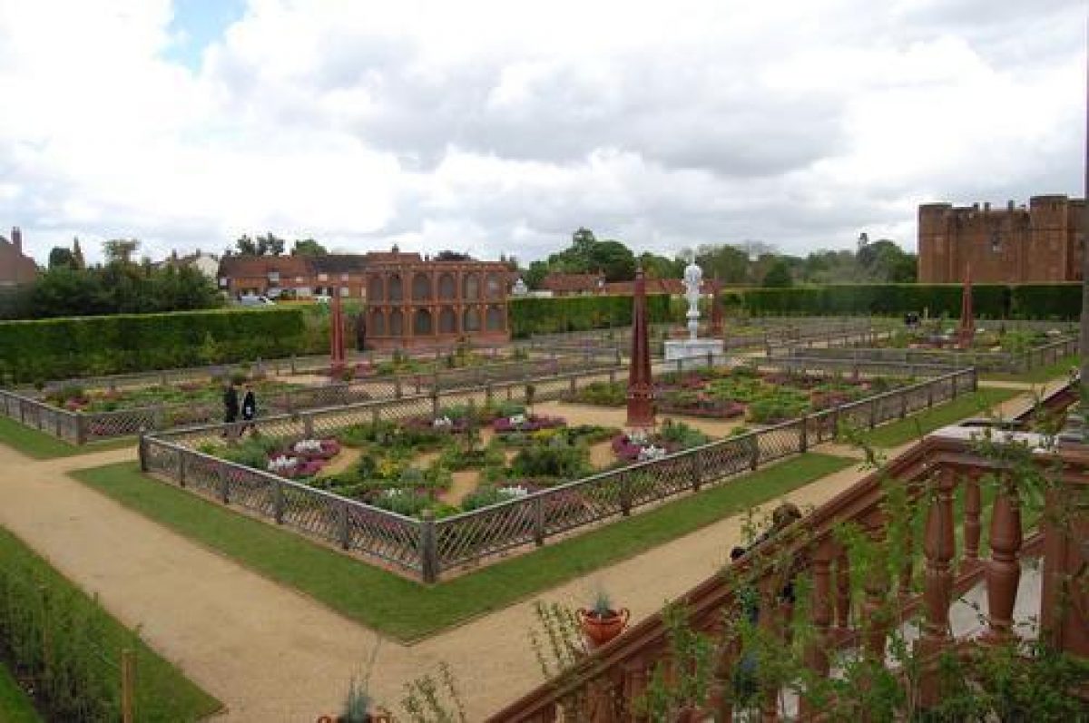
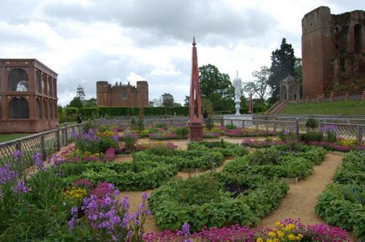
Some 50m west of the Gatehouse and immediately north of the keep is the site of the late C16 garden created by the Earl of Leicester. The garden is today approached by a gravel walk south-west of the Gatehouse and is enclosed to the east, north and west by beech hedges which are planted on the line of C16 walls. The curtain wall to the north was demolished in the mid C17, and was later replaced by a brick and stone wall on a course slightly further north. To the south the garden is bounded by a grass bank which ascends to the north facade of the keep. The bank represents the remains of a terrace constructed by Leicester in 1570 as a platform from which the garden could be viewed; a large archway to the west of the keep formed the principal access from the buildings of the inner court and was also formed in 1570 (guidebook). The garden is approximately rectangular on plan, tapering to the north-east, and is laid out as a parterre with perimeter gravel walks and further gravel walks dividing the grass panels within the parterre. To the west a cruciform arrangement of four rectangular lawns is laid out with four box-edged beds of varying sizes on each lawn; the edges of the lawns are marked by pyramid topiary yews. The box-edged beds in each quarter are laid out in different patterns, and the parterre is asymmetrical. At the centre of the west parterre is a circular lawn with clipped quadrants of yew encircling a central circular feature of clipped box. To the east a pair of further rectangular lawns are laid out with similar arrangements of box-edged beds planted with low herbs and lavender. The present garden was planted by English Heritage in 1970, and reflects in its broad outlines the plan of the C16 garden published by William Dugdale in 1656 in his Antiquities of Warwickshire, an early C18 view based on a lost early C17 original (Aylesford Collection), and late C20 excavations. Further details of Leicester's garden are known from Robert Laneham's detailed description in his account of Queen Elizabeth's visit to Kenilworth in 1575 (Strong 1998). The south terrace, which stood some ten feet above the parterre, was twelve feet wide and ornamented with obelisks, spheres and Leicester's heraldic emblem, the bear and ragged staff, with arbours to east and west (ibid). Opposite the terrace, on the north side of the garden, an aviary of timber construction was gilded and painted with representations of precious stones. The garden was divided into quarters with grass walks edged with sand, with an obelisk surmounted by an orb of porphyry at the centre of each quarter; these were surrounded by fragrant herbs and fruit trees. At the centre of the garden was a basin containing a marble fountain some eight feet high which comprised a pair of athletes supporting an orb surmounted by a bear and ragged staff (Laneham (see Kein 1983); Strong 1998). Leicester's garden was inspired by early French Renaissance chateaux gardens (Strong 1998), and as the culmination of the C16 landscape around the Castle, had a complex iconography designed to impress the Queen (Garden Hist 1999)
To the west of the garden and separated from it by a stone wall concealed by a beech hedge, a roughly triangular area north-west of the Strong Tower is enclosed to the west by the curtain wall, and to the south by a lateral wall which connects the curtain wall to the west-facing slope below the Strong Tower. Today (2000) laid to grass, this area was the site to which Henry VIII removed the banqueting house from Henry V's Pleasance in the early C16. To the south of the lateral wall a substantial earth mound (now laid to grass) abuts the west facade of the great hall; this was a vantage point for viewing the Mere to the west.
The site of the Pleasance (scheduled ancient monument) lies c 1km west-north-west of the Castle, today approached along Purlieu Lane to the north and north-west of the Castle. Some 130m north-west of the Castle, Purlieu Lane crosses the Finham Brook on a causeway and small bridge which occupy the site of a substantial late C16 timber bridge constructed by Leicester to provide access to the Chase. The site of the Pleasance now comprises a roughly diamond-shaped raised platform surrounded by two substantial concentric ditches; the ditches are separated by a flat-topped terrace walk (Taylor 1998). The outer ditch extends south-east towards the site of the Mere at the south-east corner of the enclosure. This was the site of the Plesauns en Marys created by Henry V in 1417 (Colvin 1963) which comprised a large stone building with corner towers set within a rectangular enclosure, and a timber banqueting house (Taylor 1998). The buildings were surrounded by gardens and an orchard. The site was abandoned in the early C16 when Henry VIII removed the banqueting house to the outer court of the Castle.
The Mere, in origin an early C13 defensive lake formed by expanding an existing artificial pool south-west of the Castle, covered some 450ha (ibid). There was a further, smaller defensive lake, the Lower Pool, to the east and immediately below the Tiltyard dam (included in the area here registered). There was a further moat to the north of the Castle, the remains of which survive to the south of Castle Green and Purlieu Lane. The Mere increasingly assumed an ornamental function enhancing the setting of the Castle in the late medieval period; in the late C16 it played an important role in the elaborate entertainment arranged for Queen Elizabeth's visit (Kein 1983). The Mere and other water defences were drained by order of Parliament in the mid C17 and have since been in agricultural use.
PARK
The site of the two parks (outside the area here registered) associated with Kenilworth Castle are today in agricultural use. The Old or Great Park, containing some 740 acres (c 308ha) in 1581 was stocked with 'deer and wild beasts' and lay to the south of the Mere and to the north of Rouncil Lane; it existed by the C11 (Shirley 1867) and was disparked in the mid C17. The Chase, which included areas known as Queen's Park and King's Wood, lay to the west of the Mere and Pleasance; its pale remains visible c 500m west of the site of the Pleasance. Of C12 origin, the Chase was considerably extended in 1302 and again by the Earl of Leicester in the late C16 (SMR) when it was stocked with red deer (Shirley 1867); the Chase was also disparked in the C17.
OTHER LAND
The Castle Fish Ponds, a group of late medieval rectangular pools (included in the site here registered) survive as archaeological features c 670m south-east of the Castle, extending c 240m south of Castle Road.
REFERENCES
W Dugdale, The Antiquities of Warwickshire (2nd edn 1730), pp 242-52
W Green and W Radcliffe, Kenilworth Illustrated (1821)
E P Shirley, Some Account of English Deer Parks (1867), p 156
E H Knowles, The Castle of Kenilworth (1872)
G Gasgoigne, The Glasse of Government: The Princely Pleasures at Kenilworth Castle, 1576 (reprinted 1910)
Victoria History of the County of Warwickshire VI, (1951), pp 132-9
H M Colvin (ed), History of the King's Works II, (1963), pp 682-5
Medieval Archaeology 8, (1964), pp 222-3
N Pevsner and A Wedgewood, The Buildings of England: Warwickshire (1966), pp 320-5
Kenilworth Castle, guidebook, (Department of the Environment 1973)
J Harvey, Medieval Gardens (1981), p 106
R J P Kein (ed), A Letter (1983)
Kenilworth Castle, guidebook, (English Heritage 1991)
S G Wallsgrove, Kenilworth 1086-1756 (1991)
G Tyack, Warwickshire Country Houses (1994), pp 113-18
Trans Birmingham Warwickshire Archaeol Soc 99, (1995), pp 81-116
R Strong, The Renaissance Garden in England (1998 edn), pp 49-51
C Taylor, Parks and Gardens of Britain A Landscape History from the Air (1998), pp 34-5
Garden History 27, no 1 (1999), pp 127-44
Maps
J Speed, The Countie of Warwick, 1610
Thomas Harding, Skeleton Map of Kenilworth, 1628 (Z150u - copy), (Warwickshire County Record Office)
J Fish, The Survey of the Manour of Rudfen with the Honour and part of the Manour of Kenilworth Castle ..., 1692 (Warwickshire County Record Office)
OS Old Series 1" to 1 mile, published 1834
OS 6" to 1 mile:
1st edition published 1886
2nd edition published 1906
3rd edition published 1926
1938 edition
OS 25" to 1 mile:
1st edition published 1886
2nd edition published 1905
3rd edition published 1925
1938 edition
Illustrations
H Beighton, Kenilworth Castle as it appeared in 1620, 1716 [based on lost original fresco at Newnham Paddox, Warwickshire] (Aylesford Collection of views of Warwickshire Seats, Birmingham Reference Library Archive)
Collection of late C18 and early C19 views of Kenilworth Castle in Aylesford Collection (Birmingham Reference Library Archive)
Archival items
De Lisle and Dudley family papers including inventory of 1583 (private collection)
Historic MSS Commission, De Lisle and Dudley I, pp 278-98
Sale particulars for the Kenilworth Castle Estate (excluding the Castle), 1917 (EAC136), (Warwickshire County Record Office)
Warwickshire SMR: WA3226-8; 6482
Description written: March 2000 Amended: May 2000; July 2000
Register Inspector: JML
Edited: January 2001
- Visitor Access, Directions & Contacts
Access contact details
The site is open daily from 10 am, except for 24, 25 & 26 December and 1 January. Closing time varies seasonally.
Directions
In Kenilworth, off the A46.
Owners
English Heritage
- History
The following is from the Register of Parks and Gardens of Special Historic Interest. For the most up-to-date Register entry, please visit the The National Heritage List for England (NHLE):
www.historicengland.org.uk/lis...
HISTORIC DEVELOPMENT
Kenilworth formed part of the royal manor of Stoneleigh in 1086, but in the 1120s it was granted by Henry I to his chamberlain, Geoffrey de Clinton, who founded the Castle. In 1173-4 Henry II acquired the Castle from Geoffrey de Clinton's grandson by exchange. Extended in the early 13th century by King John and provided with a large defensive lake or mere and other defences, Kenilworth remained a royal fortress until 1238 when Henry III granted it to Simon de Montfort. Following de Montfort's rebellion and death at the Battle of Evesham in 1265 the Castle reverted to the Crown, and was granted to Henry's younger son, Edmund, Duke of Lancaster.
In the mid-14th century the Castle passed by marriage to John of Gaunt, who undertook an ambitious programme of rebuilding. When Gaunt's son succeeded as Henry IV in 1399 Kenilworth became once again a royal castle, and in the early 15th century Henry V constructed the Pleasance or banqueting house to the north-west of the Great Mere. Kenilworth remained a possession of the Crown until 1553 when Edward VI granted it to John Dudley, Duke of Northumberland. Following Northumberland's execution under Mary I the Castle reverted to the Crown, but in 1563 it was granted by Elizabeth I to Dudley's son, Robert, who was created Earl of Leicester in 1564.
Leicester made extensive alterations and embellishments to the Castle, including constructing new gardens; the Queen was entertained at Kenilworth on three occasions before Leicester's death in 1588. Kenilworth was inherited by Leicester's brother, Ambrose, Earl of Warwick and subsequently passed to his son, Robert Dudley, from whom it was recovered by James I in 1611. The Castle was garrisoned by the Crown during the Civil War, but it was occupied by Parliamentary troops after the Battle of Edge Hill. In 1649 the defences were 'slighted' by blowing up the north wall of the keep and draining the Mere. Colonel Hawkesworth, the Parliamentary commander acquired the Castle and converted Leicester's gatehouse into a dwelling.
At the Restoration the Castle was recovered by the Crown, and in 1665 it was granted by Charles II to Lawrence Hyde, Earl of Rochester, from whom it passed to Thomas Villiers, Earl of Clarendon. Kenilworth remained in the possession of the Clarendon family until 1917 when the agricultural estate was sold; the Castle itself was sold in 1937 by the sixth Earl to Sir John Davenport Siddeley, later Baron Kenilworth, who in turn conveyed it to Kenilworth Urban District Council. The Council placed the Castle in the guardianship of the Ministry of Works, and today (2000) it is maintained by English Heritage.
After the Civil War the Castle was not inhabited, but the gatehouse was let to a variety of tenants. Similarly the Mere was not restored, but reverted to agricultural use. In the late 18th and early 19th centuries the ruins of Kenilworth Castle became a noted destination for visitors to Warwickshire; and in 1821 Sir Walter Scott published his novel Kenilworthwhich was inspired by a visit to the Castle in 1815. In the late 19th century the estate farms were let to Charles Trepplin, who implemented an experimental regime of agricultural improvement (Warwick Advertiser); these continue in private ownership.
- Features & Designations
Designations
The National Heritage List for England: Register of Parks and Gardens
- Reference: GD1472
- Grade: II*
Style
Tudor-Style Garden
Features
- Knot Garden
- Description: The garden was laid out by Robert Dudley, Earl of Leicester for the pleasure of Queen Elizabeth who visited the site on four occasions. The garden is laid out in four quadrants, centred on a marble fountain. Each quadrant has an obelisk surrounded by planting.The original garden was probably planted with scented perennials. Langham's 1575 account describes the sweet scent in the garden. There were also fruit trees, probably of French varieties.The reconstructed garden features plants which would have been available in the Elizabethan era, designed to be at their peak in July when Elizabeth made her longest visit. There are also traditional English varieties of fruit trees.
- Fountain
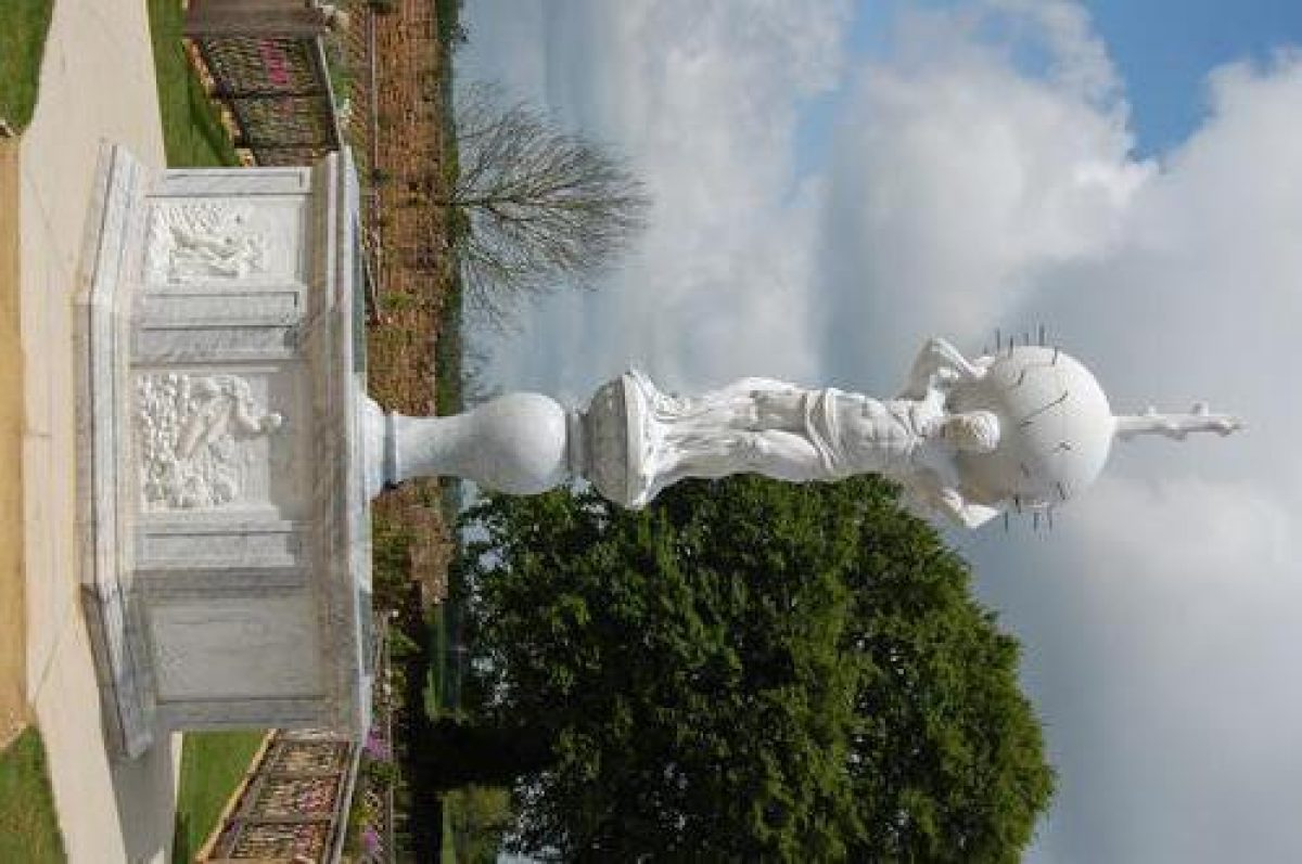
- Description: The original fountain in the garden was descibed as being octagonal in shape. The fountain foundation was discovered during excavation in 2005, associated with two stone-built culverts. Fragments of white marble were also found. The new fountain is made of Carrara marble and stands 5 metres high. Like the original, the fountain is eight-sided, with a scene from Ovid's Metamorphoses carved on each panel. The fountain is topped by a male figure holding a sphere, from which the water jets spray.
- Terrace
- Description: The grass terrace is on the south side of the garden. The front of the original terrace was removed by a ditch dug during the Civil War. The terrace has been reconstructed using measurements from Langham's letter.
- Obelisk
- Description: In the centre of each quadrant of the knot garden is an obelisk over 5 metres high. These are described in Langham's 1575 letter as being made of stone, but there is no archaeological evidence in support of this. It is likely that the features were actually of painted wood, a common material for this sort of use in the Elizabethan period. These features have been reconstructed in wood.
- Aviary
- Description: No remains of the original aviary have been discovered, as its traces were probably removed along with the adjacent north wall. Dimensions of the feature and details of its decoration are given in Langham's 1575 account, from which it has been reconstructed.
- Arbour
- Description: Langham describes two arbours, one at each end of the terrace. These have also been reconstructed, based on an engraving by Jacques Androuet Du Cerceau.
- Castle (featured building)
- Description: The castle was founded in the 1120s, rebuilt in the 14th century. It was not inhabited after the Civil War. In the late-18th and early-19th centuries the ruins of Kenilworth Castle became a noted destination for visitors.
- Earliest Date:
- Latest Date:
- Key Information
Type
Garden
Purpose
Ornamental
Principal Building
Domestic / Residential
Survival
Reconstructed
Hectares
120
Open to the public
Yes
Civil Parish
Kenilworth
- References
References
- {English Heritage Register of Parks and Gardens of Special Historic Interest}, (Swindon: English Heritage, 2008) [on CD-ROM] Historic England Register of Parks and Gardens of Special Historic Interest
- Strong, R. C., {The Renaissance Garden in England} (London: Thames and Hudson, 1979), pp.49-51 (1998 edition) The Renaissance Garden in England
- Pevsner, N. and A. Wedgwood, {The Buildings of England: Warwickshire} (Harmondsworth: Penguin Books, 1966), p. 320-5 The Buildings of England: Warwickshire
- Tyack, G., {Warwickshire Country Houses} (Chichester: Phillimore, 1994), pp. 113-8 Warwickshire Country Houses
- Saltzman, L.F. {Victoria County History: Warwick, Volume 6} (London: Oxford University Press, 1951), p. 132-9 Victoria County History: Warwick, Volume 6
- Land Use Consultants {Kenilworth Castle: landscape appraisal} (1985) Kenilworth Castle: landscape appraisal