Introduction
Youngsbury has an mid-18th-century landscape park and woodland covering about 56 hectares. The gardens around the house occupy about four hectares, including 16th- and 18th-century walled gardens.
Terrain
The house stands on a plateau above a valley to the west and south, through which the River Rib flows.www.historicengland.org.uk/listing/the-list
A mid C18 landscape park designed by Lancelot Brown, c 1760s or earlier, surrounding a mid C18 country house.
DESCRIPTION
LOCATION, AREA, BOUNDARIES, LANDFORM, SETTING
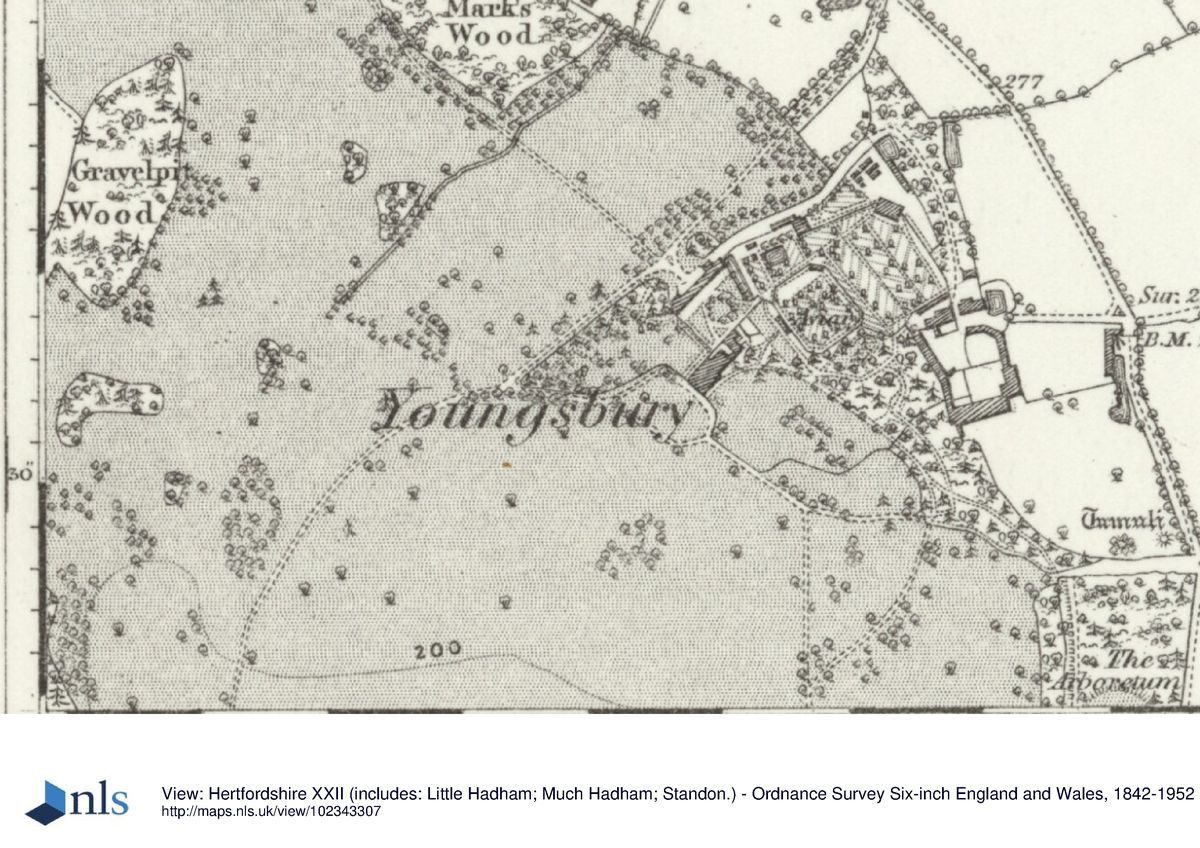
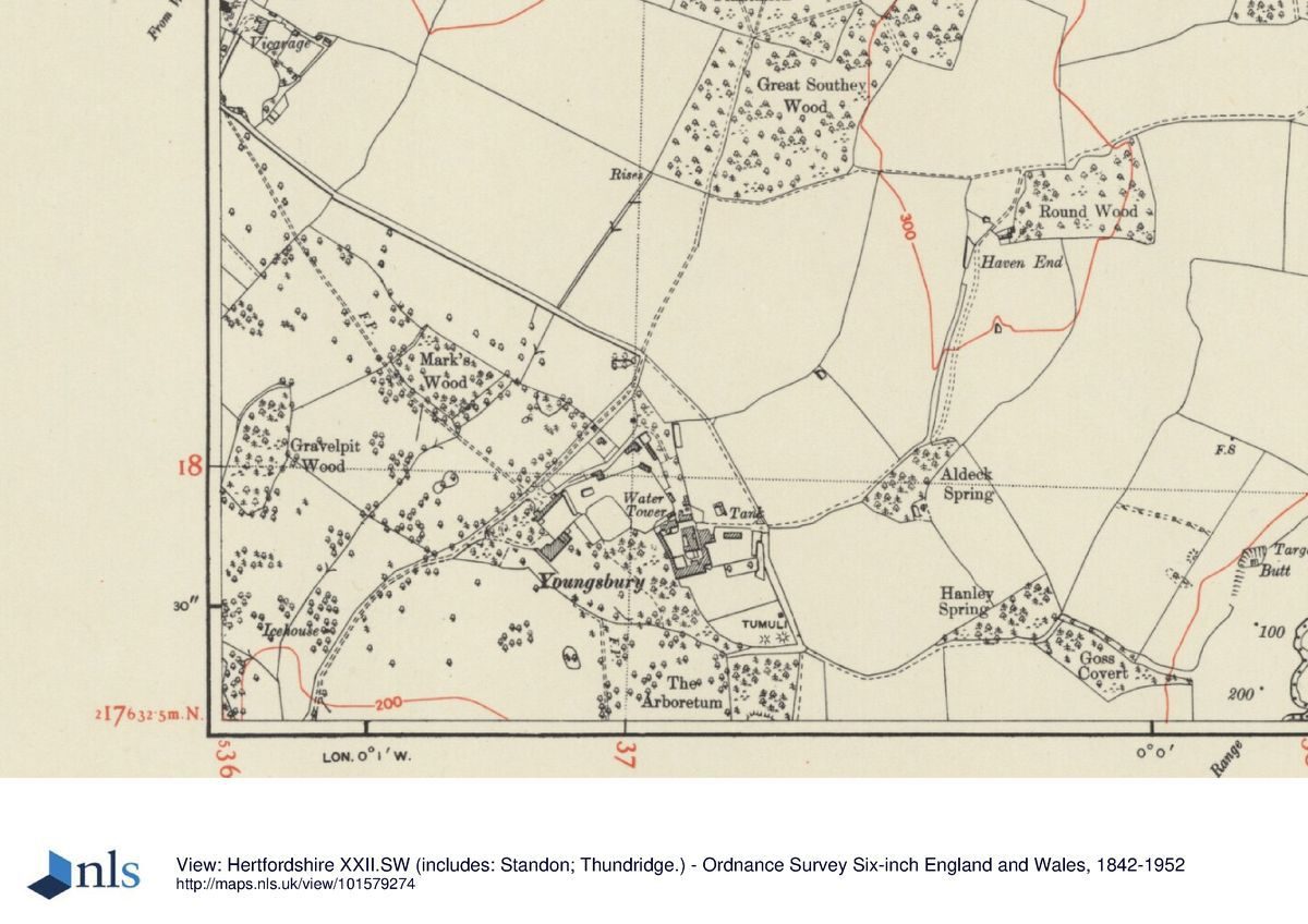
Youngsbury lies 3km north of the centre of Ware, between the villages of High Cross to the north-west and Wadesmill to the south-west. The c 60ha site is bounded largely by agricultural land, with part of the south boundary being marked by a footpath linking Wadesmill to the ruined remains of the church of St Mary and All Saints, the tower of which stands in the churchyard at the south side of the park (scheduled ancient monument, outside the area here registered). The Home Farm stands adjacent to the north-east boundary (outside the area here registered). The house stands on a plateau above a valley to the west and south, through which the River Rib flows, its course having been altered to Brown's design. The setting is largely rural, with views south across the valley to the rising slopes of Thundridgehill beyond.
ENTRANCES AND APPROACHES
The west drive, designed by Brown, approaches the park off the A10 in the centre of the village of Wadesmill, entering at a single-storey, stuccoed lodge in Tudor style standing 1km south-west of the house. A pair of stone piers supporting iron gates flank the entrance to the drive, close to which on the north side stands the lodge, with the River Rib close by to the south. From here the drive, largely flanked by mown grass verges, extends east through farmland, bordered on the north side by a line of ornamental trees including walnuts, sweet chestnuts and horse chestnuts. The drive enters the open parkland 600m south-west of the house, at the inner gate, standing at the east edge of Lower Millfield Wood. Formerly, as the drive emerged from the Wood, the house was revealed on the plateau above to the north-east, standing within rolling parkland, but this view is now (1999) obscured by late C20 planting. Brown had planned two pairs of clumps flanking the drive, where now (1999) it enters and leaves Lower Millfield Wood, which would have had the effect of suddenly revealing the house set in the park, but the sites of these clumps have since been incorporated in the woodland. A group of mature trees flank the drive at the east edge of the woodland, possibly the remains of the easternmost pair of clumps.
From Lower Millfield Wood the drive sweeps north-east across the park, ascending the gentle hillside to the plateau and house, overlooking the river valley to the south and agricultural land on Thundridgehill beyond this, and the parkland in the valley to the west. Some 50m north of the house the drive turns south-east to the stable block, which stands at the entrance to the stable yard beyond. The drive continues through an archway in the centre of the stable block, crossing the stable yard to its southern corner, to enter the forecourt which lies on the north-west front of the house. Here a gravel carriage sweep leads up to a small portico on the north-west front, overlooking a lawn flanked to the north-east by the brick wall of the stable yard, and to the south-west by a copse of trees. A further entrance to the forecourt lies at its west corner, formerly giving access from a short spur off the west drive 75m west of the house (OS 1925).
The north drive enters the park 250m north of the house, off the lane linking High Cross with Home Farm to the south-east. The drive extends south-west to join the west drive close to the entrance to the stable block.
A further drive, now lost, formerly approached directly from High Cross to the north-west, leaving the High Cross to Home Farm lane 750m north-west of the house, and extending south-east through the park to join the north-east drive opposite the stable block, 50m north of the house (OS 1925).
Following the completion of the landscaping of the park in the late C18, the lane from High Cross lay c 100m south-west of, and approximately parallel with its present course, its former course still (1999) largely marked by the present north-east park boundary (estate map, 1793). The lane divided the house and main garden enclosure, including the enclosed octagonal core of the present kitchen garden, from a woodland to the north (in the C19 felled and the land incorporated within the kitchen garden complex) and the Home Farm lay adjacent to the east of this. By the late C19 (OS 1883) a strip of agricultural land separated the park from the relocated lane which was lined by an avenue of trees.
The former approach to the house, as designed by Brown, c 1760s, and in existence until the late C19 (OS), led off the west drive c 125m west of the house, directly to the south-west front (where now lies a terrace and lawn above a ha-ha overlooking the park). Traces of the drive remain in earthwork form in the parkland pasture, close to the present drive. The drive enclosed a carriage circle by the south-west front of the house, and from this a further, south-east drive (gone, 1999) extended south-east into the park to what is now (1999) the north end of The Arboretum, 300m south-east of the house. Here the drive emerged from the park onto the lane linking High Cross with Home Farm and with Fabdens further to the south-east (outside the area here registered). A spur off that south-east drive (now gone) extended south across the park to meet a spur eastwards from the west drive (both now gone) c 250m south of the house, close to the site of the Bath House at the edge of the Broad Water. From here they continued east as a single drive along the north bank of the Broad Water, to the south-east boundary of the park (estate map, 1793).
PRINCIPAL BUILDING
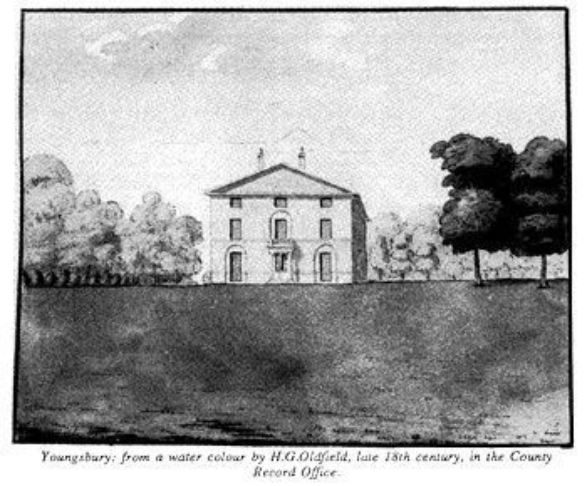
Youngsbury (1745, altered 1769, C19, c 1950, listed grade II) stands towards the north-east boundary of the park, by which it is largely surrounded, with the kitchen garden and service yards lying adjacent to the north and north-east. The two-storey mansion of plum-red brick was built as a pedimented Palladian villa of three storeys, but the top storey was removed c 1950. A two-storey C19 block on the north-east side links the mansion with an C18 brewhouse range. A tall, hexagonal louvred game larder occupies part of the link to the brewhouse range. The north-west front is the present entrance front (1999), the entrance having been moved from the south-west front when the approaches were remodelled in the late C19/early C20. The south-east and south-west fronts give onto the gardens. The south-west front overlooks the river valley, and agricultural land beyond the park boundary, possibly formerly enjoying a view of the tower of the ruined church of St Mary and All Saints to the south. Late C20 planting has obscured this and other of the distant views.
The stable block (c 1769, listed grade II) stands c 40m north of the house, bounding the north-west side of the stable yard. The rectangular, two-storey range is built in Palladian style of plum-red bricks. An arched carriageway pierces the pedimented centre block, above which stands a cupola. The carriageway gives access for the west and north drives to the stable yard and forecourt.
GARDENS AND PLEASURE GROUNDS
The gardens enclose the house on the south-west and south-east fronts. A gateway leads from the south corner of the forecourt, via an iron gate set into a clipped yew hedge, to a stone-flagged terrace, supported by a brick retaining wall, running along the south-west front. The terrace extends south-east beyond the south corner of the house to separate the south-west and south-east lawns. A flight of brick and stone steps centred on the south-west front leads down from the terrace to an informal lawn below, bounded by a rendered ha-ha, with views over the parkland beyond. The terrace continues along the south-east front of the house, overlooking an informal lawn. The south-west side of the lawn is partly bounded by a copse of trees, and the north-east side is bounded partly by the kitchen garden walls and by mature trees set in lawn.
From the east corner of the south-east lawn, a path leads south-east through wooded pleasure grounds, its southern end being slightly sunk whilst running through a narrow belt of mature trees underplanted with evergreen shrubs including box, holly, Portuguese laurel and yew. In places the path looks out over the park and hillside beyond to the south. This pleasure ground walk was laid out in the late C18 (estate map, 1793), following Brown's suggested route. The path terminates at The Arboretum, a C19 woodland, in which lie the remains of extraction pits, and two broad flights of brick steps, the remains of an ornamental walk, probably also from the C19. Some mature exotic conifers remain, others having been replanted in the 1980s. Two tumuli lie 200m south-east of the house, at the north end of The Arboretum.
PARK
The park is divided into two sections, centred on the west valley and on the south valley and Broad Water, the valleys meeting at the south-west corner of the park. It is largely laid to pasture with many clumps and scattered single trees, including cedars, limes and copper beech, with blocks of woodland mainly sited on the boundaries.
The south valley is bisected from east to west by the River Rib, widened and smoothed at Brown's suggestion into a sinuous river, the Broad Water, flanked by a hillside to the north leading up to the plateau on which the house stands, and largely level meadows to the south. A narrow arm of the River Rib crosses the meadows to rejoin the Broad Water 400m south-west of the house. Many mature trees grow along the banks of the Broad Water, obscuring Brown's intended view of its course from distant parts of the park. Along the east half of the Broad Water stand several very large plane trees (probably C18), some set in an area of wooded pleasure ground on the north bank in which stand the remains of the rectangular Bath House, 300m south-east of the house, now derelict and ruined. The remains of one wall, standing adjacent to the Broad Water, show that this building had flint exterior walls and brick interior walls.
The remains of the demolished C16 manor house, Thundridgebury House (scheduled ancient monument), the predecessor of the present mansion, stand adjacent to the south boundary 450m to the south, in a large moated enclosure. The site of the former mansion, and its immediate surrounds, is planted with mature trees, and lies adjacent to the associated remains of the church of St Mary and All Saints and accompanying graveyard (part of the same scheduled ancient monument). All that remains of the church above ground is the tower, visible from various parts of the park, and possibly formerly used as an eyecatcher in views from the house and west drive.
The west valley runs north from the south valley to Mark's Wood on the north-east boundary. A brick icehouse (date stone 1793, listed grade II) is set into the east side of the valley, lying c 350m south-west of the house in a clump of trees. Its doors have been lost but the central chamber and earthen cover remain intact.
The main features of Brown's proposals, to enhance the already picturesque grounds, were carried out. They included the west drive and associated drive system, the widening of the Rib into a river visible from the house, and strategic planting of trees in copses, clumps and as individuals.
KITCHEN GARDEN
The extensive, red-brick-walled kitchen garden (C18 with C19 alterations, listed grade II) stands to the north-east of the mansion. It is divided into several concentric sections by walls, that at the centre being octagonal and laid to lawn planted with orchard trees. This section is bisected by two paths in cruciform pattern, meeting at the centre of the area at a pergola. The area is entered from two gateways with iron gates set into the south-west and north-west walls. The former entrance gives direct access from the house via the south-east lawn; the latter entrance gives access to the stable yard to the west and the encircling sections of the kitchen garden to the north. These outer enclosures are now largely laid to lawn. A rectangular pond lies close to the north-west gateway, separating the stable yard from the kitchen garden to the north-east.
REFERENCES
Victoria History of the County of Hertfordshire 3, (1912), pp 357-8
D Stroud, Capability Brown (1975), pp 245-6, pl 35b
B Cherry and N Pevsner, The Buildings of England: Hertfordshire (1977), p 364
Maps
Plan proposed by Lancelot Brown for the Improvement of Youngsbury after remarking that Nature had do[ne] so much that little was wanting, but enlarging the River, nd, c 1760s (private collection) [copy in Hertfordshire Record Office]
Dury and Andrews, A topographical Map of Hartford-shire, 1766
A survey of Youngsbury and Farm ... the estate of Mrs James Poole, 1768 (Hertfordshire Record Office)
The site of the Mansion House, Paddock, and Lands of William C Shaw ..., 1793 (Hertfordshire Record Office)
A Bryant, The County of Hertford, 1822
OS 6" to 1 mile:
1st edition published 1883
2nd edition published 1896
3rd edition published 1925
OS 25" to 1 mile: 2nd edition published 1898
Description written: August 1999
Register Inspector: SR
Edited: October 2000
- Visitor Access, Directions & Contacts
Directions
East of the A10, north of Hertford.
- History
The following is from the Register of Parks and Gardens of Special Historic Interest. For the most up-to-date Register entry, please visit the The National Heritage List for England (NHLE):
www.historicengland.org.uk/listing/the-list
HISTORIC DEVELOPMENT
In 1545 Richard Wytherall consolidated his ownership of the manor of Youngs by acquiring the last part of the manor not in his ownership. The manor descended to David Poole (d 1758), who c 1745 built a new mansion at some distance north of the old one which was demolished. The manor was sold by Poole's widow to David Barclay in 1769, who improved and enlarged the house (VCH).
During the 1760s, or possibly earlier, Lancelot Brown (1716-83) produced an undated design for the park, inscribed Plan proposed by Lancelot Brown for the Improvement of Youngsbury after remarking that Nature had do[ne] so much that little was wanting, but enlarging the River, the scheme involving little change to the topography of the park. The scheme was largely carried out, although whether the works were supervised by Brown using one of his foremen, or executed by the estate, is not known. Plans of the late 1760s (Dury and Andrews, 1766; A survey of Youngsbury and Farm ... the estate of Mrs James Poole, 1768) show the old course of the River Rib running unaltered through the park, although on the 1768 plan various clumps and other trees are by that time shown. By 1793, when the estate was sold to William Shaw, the park had been completed (The site of the Mansion House, Paddock, and Lands of William C Shaw ... , 1793). In 1796 Shaw sold the estate to Daniel Giles (d 1800), Governor of the Bank of England, in whose family it remained during the C19.
The estate remains (1999) in private ownership.
- Associated People
- Features & Designations
Designations
The National Heritage List for England: Register of Parks and Gardens
- Reference: GD1167
- Grade: II*
Features
- Ha-ha
- Icehouse
- House (featured building)
- Earliest Date:
- Latest Date:
- Woodland
- Walled Garden
- Parkland
- Key Information
Type
Park
Purpose
Ornamental
Principal Building
Domestic / Residential
Survival
Part: ground/below ground level remains
Hectares
60
Open to the public
Yes
Civil Parish
Thundridge
- References
References
- {English Heritage Register of Parks and Gardens of Special Historic Interest}, (Swindon: English Heritage, 2008) [on CD-ROM] Historic England Register of Parks and Gardens of Special Historic Interest
- Stroud, D., {Capability Brown} (London: Faber, 1975), pp. 245-6, plate 35b Capability Brown
- Pevsner, N. and B. Cherry, {The Buildings of England: Hertfordshire} (Harmondsworth: Penguin, 1977), p. 364 The Buildings of England: Hertfordshire
- Page, W {Victoria County History: Hertford, Volume 3} (1912) 357-8 Victoria County History: Hertford, Volume 3
- Capability Brown's design for Youngsbury, Standon 1770