Introduction
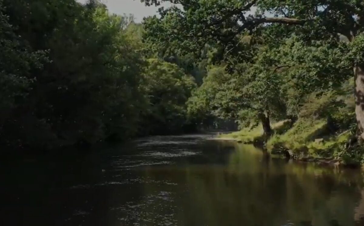
Willersley Castle is situated on the gorge of the river Derwent, with riverside and woodland walks. The site, occupying about 22 hectares, comprises some 13 hectares of pleasure grounds and picturesque walks, and about 9 hectares of parkland.
Terrain
The site has a dramatic landform with partly wooded, rocky cliffs and west-facing slopes descending to the River Derwent to the north-west of the Castle; there are further cliffs to the north-east.The following is from the Register of Parks and Gardens of Special Historic Interest. For the most up-to-date Register entry, please visit The National Heritage List for England (NHLE):
Late 18th and early 19th century picturesque pleasure grounds and park laid out by John Webb for Sir Richard Arkwright and his son, Richard Arkwright.
Location, Area, Boundaries, Landform and Setting
Willerlsey Castle is situated c 1.25km south-east of Matlock Bath and c 0.25km north-east of the village of Cromford, to the north of the River Derwent which sweeps from north to east through the site. The c 22ha site comprises some 13ha of pleasure grounds and picturesque walks, and c 9ha of parkland. To the north-west the site is bounded by stone walls and rocky outcrops which separate it from Lovers Walks, while to the west the River Derwent forms the boundary. Stone walls to the south-west separate the site from the A6 road, while to the south the boundary is formed by the summit of Scarthin Rock and stone walls which enclose late C18 mill buildings. The south-east boundary is formed by stone walls which adjoin Mill Road, while to the east Cromford Bridge and stone walls bounding Willersley Road form the boundary.
Farm buildings to the east of Home Farm, now (2000) known as Derwent House, which in the late C20 have been converted to domestic use, are excluded from the site here registered. To the north fences above cliff faces separate the site from adjacent farmland, while to the north-west of the kitchen garden the site boundary is formed by a brick wall c 3m high. The site has a dramatic landform with partly wooded, rocky cliffs and west-facing slopes descending to the River Derwent to the north-west of the Castle; there are further cliffs to the north-east. The ground rises to Cat Tor, a rocky peak c 80m north-west of the Castle, from which there are extensive views north and west along the Derwent gorge and across Matlock Bath to the Heights of Abraham (qv), and south-west across the Derwent to the late C18 and C19 Masson Mill c 260m west-north-west of the Castle. The site also rises to the north-east, with a south-facing slope between these points of high ground lying above the Castle.
The ground drops sharply below the Castle and pleasure grounds to the park, which slopes gently south to the River Derwent. To the south of the river the ground slopes gently up to the sheer face of Scarthin Rock c 200m south of the Castle. The site enjoys extensive views north along the Derwent gorge to Matlock Bath, south to Scarthin Rock and south-west towards Cromford. Cromford Court, an early C20 mansion c 350m west of the Castle and Masson Mill c 240m to the north-west are prominent in views from the pleasure grounds and park. To the east and south-east there are views down the Derwent valley to Cromford church, Cromford Bridge and an early C18 fishing temple, and beyond to meadows, c 530m south-east of the Castle, which assume a park-like character with scattered groups of trees.
Entrances and Approaches
Willersley Castle is approached from Willersley Road immediately to the north of Cromford Bridge. A tarmacked approach from the public road is flanked by low stone quadrant walls which are surmounted by early C19 cast-iron railings. Some 15m north-west of the road a pair of late C18 rusticated stone piers of square section with fluted friezes and moulded caps are flanked by a further pair of identical stone piers which support two plain wrought-iron pedestrian gates (all listed grade II). To the north of the gates and immediately within the site stands a late C18 two-storey stone lodge (listed grade II), the ashlar façade of which has a recessed arched centrepiece which is flanked by a pair of carved quatrefoils. The lodge was designed by Thomas Gardner.
The tarmac drive extends c 80m north-west, and is adjoined to the north-east by Derwent House, formerly Home Farm (listed grade II), a late C18 three-storey stone house with an ornamental façade facing across the drive to the park. The drive turns to the west and rises for c 270m to reach a carriage court at the south-east corner of the Castle. To the north, the drive is bordered by evergreen shrubbery and mature trees, beyond which rise picturesque rocks; to the south a wide grass verge is separated from the park by a C19 iron fence. The park drops steeply below the drive and carriage court, revealing views south to the river and Scarthin Rock and south-east to Cromford church.
A drive ascends north-east from the carriage court for c 80m to reach the late C18 stables c 50m north-east of the Castle. The drive is screened by mature evergreen shrubbery and trees, and is bordered by rocks, being partly cut through solid rock. To the north a path runs parallel and immediately above the drive from the service quarters to the stables. The stables, today (2000) converted to residential use, comprise a three-sided cobbled court closed to the south by a wall and railings. The stables are entered through an arch in the east range.
In the early C19 pedestrians approaching Willersley Castle from Matlock Bath entered the site at a gate c 200m south-south-west of the Castle, on the south side of the River Derwent. Today (2000) tall octagonal stone piers and C19 cast-iron gates with pierced quatrefoil ornaments survive flanked by low stone walls to the north and Scarthin Rock to the south. An early C19 lodge to the north-west of the gate does not survive. A partly gravelled walk, today known as Church Walk but in the late C18 known as Chapel Walk, extends c 400m east-north-east parallel to Scarthin Rock to the south and the river to the north. The ground drops away towards the river, revealing views across the park to Willersley Castle, while to the east the walk is aligned on the west façade of St Mary's church which was built as a private chapel by Sir Richard Arkwright to the design of Thomas Gardner c 1792; the original structure, now (2000) a parish church, was Gothicised in 1858 (Pevsner and Williamson 1979). The church stands in a small grass enclosure planted with yews which is separated from the surrounding park by low C19 cast-iron fences; it was built on the site of an C16 lead smelting mill (survey, 1759).
To the south of the church and Church Walk yews planted on a bank screen C18 industrial buildings south-east of Mill Road, while to the south-west, adjacent to the C18 mill buildings, is an area of late C20 car park screened by ornamental planting. Tall, square section stone piers support a single C19 timber gate immediately south of the church: this gateway leads to a cobbled area flanked by stone quadrant walls adjacent to Mill Road. The Church Walk is illustrated in Joseph Wright's c 1790 view of Willersley Castle from the south-west (Harris 1979).
Late C18 and early C19 tourists left the pleasure grounds by the upper gate connecting walks in the grounds of the Castle with those in Lovers Walks immediately to the north. A level riverside walk leads to a lower C19 cast-iron gate with a spiked top rail set in a rubble-stone wall c 530m north of the Castle; the wall extends c 60m east from the river to the west-facing cliffs in Hagg Wood, passing an intermediate gate (gate missing, 2000). A third, upper doorway (door missing, 2000) comprising an ashlar surround surmounted by rustic stonework is set against west-facing cliffs c 560m north-north-east of the Castle and leads to a steep, serpentine path which descends below the cliffs into Lovers Walks.
Principal Building
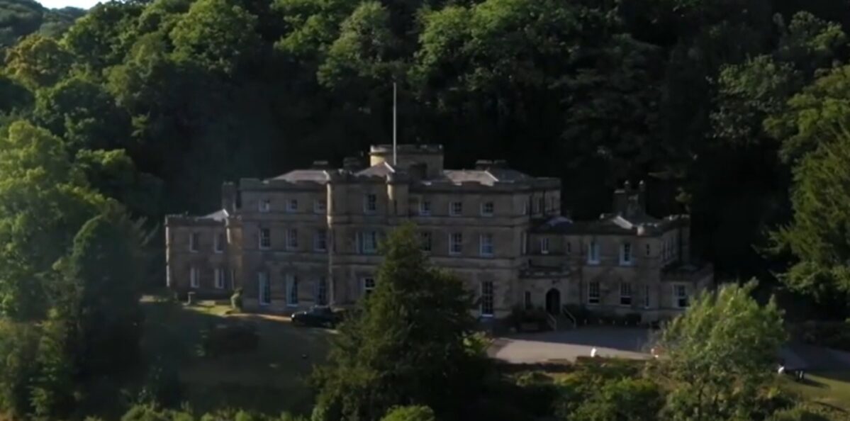
Willersley Castle (listed grade II*) stands on an artificially levelled platform cut into the south-facing rocky hillside to the north of the River Derwent. The site was undeveloped when acquired by Arkwright in 1782, and the house, a picturesque castle, was begun to designs by the London architect William Thomas in 1786. Following a fire the building was completed after Sir Richard Arkwright's death in 1792 by Thomas Gardner of Uttoxeter. The Castle, constructed throughout in local stone, comprises a central range of three storeys which has a centrepiece ornamented with a monumental arch flanked by a pair of round turrets. The central range is flanked to east and west by recessed two-storey wings which are ornamented with further round turrets. The Castle is entered through a single-storey gothic porch set in the angle between the principal range and the east wing. An elliptical galleried hall to the north of the principal range rises above the roof line giving the appearance of a further low tower. The parapets of the building are embattled throughout.
Gardens and Pleasure Grounds
The formal and informal gardens lie to the east, north and west of the Castle. To the south of the Castle, a tarmac walk extends west from the carriage court with an area of lawn planted with late C20 specimen trees and shrubs sloping south to the park. Stone steps flanked by clipped box descend to the lawn from a French window at the centre of the south façade of the Castle. To the south-west of the Castle a sundial set on a massive circular pedestal stands on a lawn, while within the recess at the south-west corner of the building there is a further lawn and a late C20 herb garden.
Stone steps ascend west to a late C19 rock garden which is constructed on the south-facing slope to the west of the Castle. Two informal flights of stone steps ascend through the rock garden, at the top of which is a rustic stone-paved path and two rectangular alpine beds. To the north and west the rock garden is enclosed by mature evergreen shrubbery. The rock garden was described in 1903 as being 'laid out in a modern style suggested by Mr F C Arkwright' (Bryan 1903). The gardens to the west and south of the Castle are today (2000) partly enclosed by the remains of C19 metal and wire fences. Below the rock garden a gravelled walk extends c 100m west to meet a walk which leads north-north-east through woodland to the west of Cat Tor. To the east dramatic, partly wooded rock faces rise to the summit of Cat Tor, while to the west the ground falls steeply to the River Derwent. The edge of the walk is ornamented with rocks, while yews have been planted on the rocks above to expose picturesquely contorted roots. The western walk continues for a further 50m before sweeping north and north-west to descend a rocky slope to reach the east bank of the River Derwent. This walk extends c 530m north to reach the lower gate leading to Lovers Walks, which is opposite the heavily calcified cascade of a petrifying spring on the west bank; the cascade, the objective of the Lovers Walks, was the subject of a painting by Thomas Smith of Derby. After c 200m the riverside walk passes a wide, semicircular weir which was constructed c 1783 to provide water for Arkwright's mill (now Masson Mill) on the west bank of the river. The weir, with an unusual down-stream curved profile, forms an ornamental cascade, while above to the north the river is widened. Below the weir are the remains of C19 stone-lined fish tanks while above are the remains of a late C18 boathouse. To the east of the walk woodland rises to picturesque cliffs, while there are significant views north along the river and south to Masson Mill.
A gravelled walk leads north-east from the carriage court, turning east to form a terrace walk extending on an approximately level course for c 270m. The rocky slope to the north is planted with evergreen shrubs and trees, while the slope below the walk is similarly planted; trees, many self-sown, now partly obscure views south across the park to the church, and south-east to Cromford Bridge and down the Derwent valley. The terrace is terminated to the east by a rock face which is picturesquely planted with yews. Here the stone-edged walk sweeps north-west, following a serpentine route through an area of box and yew, with picturesque rock faces to the east and isolated groups of rocks framing dramatic views south-east down the river valley. The walk turns west for c 130m and passes above an area which is today woodland and rhododendrons, but which in the C19 was an area of paddock (Tithe map), before turning north for c 100m. Here the walk is planted with mature beech and has alternate views north and north-east across farmland in a valley to the north-east of the site, and south-west across an area of sloping south- and south-west-facing grass which in the C19 was a further area of paddock (Tithe map). The walk sweeps west for c 130m, passing through shrubbery to the south of the kitchen garden and to the north of the paddock. To the north of Cat Tor the walk descends to join the walk which leads north from the gardens west of the Castle below the west face of Cat Tor. Some 50m south of this junction, a narrow walk leads south-east through ferns and picturesque rocks round Cat Tor, gradually climbing to its summit which is approached from the south across a rustic stone bridge. Here a level area partly surrounded by low thorns and late C20 timber railings affords extensive views north up the Derwent gorge, across the Lovers Walks and Matlock Bath to the Heights of Abraham; there are also views west and south-west across the Derwent to Masson Mill and Harp Edge. Informal serpentine walks descend the south slope of Cat Tor to join a gravelled walk c 50m west of the stables.
To the west of the kitchen garden a small formal rose garden is enclosed to the south by the remains of C19 metal and wire fencing, to the west by planting along the edge of cliffs, to the north by a brick and stone wall, and to the east by the wall of the kitchen garden, which is here faced with stone. A border below the kitchen garden wall is planted with shrubs and climbers, while geometric beds (replanted c 1990) are cut in the south-facing sloping lawn. A gravel walk runs parallel to the kitchen garden wall and ascends a short flight of stone steps to an upper terrace, where the stone foundations of an early C19 detached conservatory form a rectangular border (Plan of Matlock Bath, 1848). To the west there are specimen C19 and early C20 conifers. The western end of the north garden wall is constructed in stone and contains a blocked gateway which leads to a beech-lined cliff-top walk. Beyond the gateway the walk reveals views north-east across agricultural land, before approaching the cliff edge to reveal 'sublime' views down into the Derwent gorge, and west and north-west across Matlock to the Heights of Abraham. The walk extends c 160m north from the gateway to picturesque rocks known as the Lover's Leap (ibid), before turning north-east and north-west and descending for c 80m to reach the upper doorway leading to Lovers Walks. This second section of the cliff walk is planted with limes.
Park
The park lies in two discrete areas to the north and south of Willersley Castle. The larger, or south park comprises level riverside meadows. Those to the north of the River Derwent are generally level with scattered groups of ornamental trees which frame views south-east, south and south-west from the Castle and pleasure grounds. The land rises sharply to the north where the park adjoins the drive and pleasure grounds. To the north-west, c 160m west of the Castle, a rocky, partly wooded spur of high ground projects south into the park, screening Masson Mill from view. The south park is separated from the pleasure grounds by C19 metal fencing, except for c 80m at the north-west end of the boundary adjacent to the river, which is closed by a stone wall. A simple timber gate set in this wall gives access to the riverside walk running through Hagg Wood which leads to the lower gate into Lovers Walks. To the south of the river the park is of similar character with scattered ornamental trees, evergreen shrubs and light woodland at the foot of Scarthin Rock to the south.
The park or paddock to the north of the Castle is today (2000) a south-and south-west-facing grassy slope which has been terraced in the early C20 to form a putting green, two tennis courts and a bowling green. At the west end of the upper terrace low stone walls and a concrete base remain from a late C19 pavilion; the upper lawn and pavilion had been formed by 1899 (OS 2nd edn). Today (2000) the west- and south-west-facing slope to the east of the tennis courts retains scattered hawthorn trees, together with late C20 specimen trees. The northern park or paddock was conceived as a picturesque feature on the circuit of the pleasure grounds, enclosed on all sides by the pleasure grounds, and overlooked by the principal walk from the east and north. The paddock was enclosed to the north and east by metal and wire fences, remains of which survive. To the south a stone wall with two gateways flanked by stone obelisk piers separates the park from the pleasure grounds west of the stables, while a stone wall composed of massive boulders links the south wall to remains of a wire fence which runs to the east of Cat Tor. C19 surveys show the park traversed from south-west to north-east by a track leading to a gateway, the C19 cast-iron posts of which survive south-east of the kitchen garden, which enabled stock to be moved into the paddock from adjacent agricultural land.
Kitchen Garden
The kitchen garden lies on high ground c 270m north-east of the Castle. Enclosed to the north, east and west by stone-coped brick walls c 4m high, and to the south by a lower brick wall to which the east and west walls sweep down, the roughly wedge-shaped garden is today being developed as the garden to a late C20 dwelling at the north end of the garden on the site of a range of C19 glasshouses (OS). A centrally placed doorway (now bricked-up) was formerly flanked by a bell-pull with which early C19 visitors summoned the gardener for guided tours of the pleasure grounds and kitchen garden. To the east of the kitchen garden a C19, stone, two-storey cottage stands in a slip which is separated from fields to the east by hedges, while to the north ancillary buildings have been converted into a further late C20 residence set in gardens developed from the frame yard and slip garden. A late C19 description indicates that there were extensive vineries, as well as peach, melon and fig houses, together with pears, plums and 'good crops of leading vegetables' in the kitchen garden (Gardeners' Chronicle 1886). These do not survive today (2000).
It is located within the Derwent Valley Mills World Heritage site.
Maps
[the following are all held in the Derbyshire Record Office]
- W Brailsford, Map of Edwin Lascelles' Estate at Willersley, 1759 (978M/E12)
- Tithe map for Cromford parish, 1841 (D2360/DL25a,b)
- Tithe map for Matlock parish, 1848 (D2360/3/28a)
- J. Gratton, Plan of Matlock Bath and its Vicinity, Derbyshire, 1848
- OS 25" to 1 mile: 1st edition surveyed 1876-1878, published 1880
- 2nd edition published 1899
Illustrations
- Joseph Wright, view of Willersley Castle and park from the south-west, c 1790 (private collection; reproduced in Country Life 1952 and Harris 1979)
- Engraving, The Seat of Richard Arkwright Esq, Matlock, Derbyshire, c 1800 (private collection)
- J P Neale, Willersley Castle, Derbyshire (in Neale 1818)
- Watercolour, view of Willersley Chapel, c 1820 (D4841/25/2), (Derbyshire Record Office)
Archival items
- Arkwright family papers including items relating to the completion and furnishing of Willersley Castle, but not the grounds, are held in the Derbyshire Record Office (978M).
- Sale particulars and plan for Willersley Castle Estate (excluding the Castle and pleasure grounds), 1924 (D1114C/ES1), (Derbyshire Record Office)
Description written: February 2000
Amended: May 2000
Edited: July 2000, December 2022
- Visitor Access, Directions & Contacts
Access contact details
Willersley Castle is now a hotel.
Directions
On the east side of the Derwent valley, south of Matlock.
- History
The following is from the Register of Parks and Gardens of Special Historic Interest. For the most up-to-date Register entry, please visit The National Heritage List for England (NHLE):
16th - 18th Century
In the late 16th century the manor of Willersley belonged to a younger son of Gilbert Talbot, Earl of Shrewsbury, from whom it passed to the Earl of Kingston. The estate was settled on a relative, William Pierrepont, before being acquired through marriage in the early 18th century by Edwin Lascelles (created Lord Harewood 1790). Lascelles' estate was surveyed in 1759, at which date it comprised meadows adjacent to the River Derwent and steeply sloping rocky woodland with further meadows on the level summit. Lascelles sold the property in 1778 to Thomas Hodges (Bryan 1903).
In 1782 it was sold again to the pioneering mill-owner Richard Arkwright (knighted 1786), who had moved his business to Cromford in 1771. The completion of a new house by William Thomas was delayed by fire in 1791, and at Sir Richard's death in 1792 it remained incomplete. Pleasure grounds were created for Sir Richard by John Webb (1754-1828) (Gardeners' Chronicle 1886), whose master, William Emes (1730-1803) had earlier worked on the adjacent Lovers Walks. Trees were planted at a rate of 50,000 annually in the late 18th century (Bryan 1903).
19th Century
Sir Richard was succeeded by his son, also Richard, who died in 1843, when Willersley was inherited by Richard Arkwright's third son, Peter (1784-1866). His descendants continued to live at Willersley Castle into the early 20th century; during the First World War it was used as an hospital.
20th Century
In 1924 much of the estate was offered for sale and the Castle was offered for lease. The Castle was sold to a consortium of Methodist businessmen in 1927, who acquired the property for use as a Methodist Guild Holiday Centre; this was opened in 1928. The Castle was requisitioned as a maternity hospital between 1940 and 1945, but reverted to its use as a holiday centre after the War; it remains in this use today (2000).
Matlock Bath developed as a spa during the late 17th and early 18th century, and from the beginning the dramatic scenery was an attraction as much as the waters. During the late 18th and early 19th century communications were improved and the town became a popular summer resort. Notable visitors included Byron who compared Matlock Bath to Switzerland, and the artists J M W Turner, Zuccarelli, Joseph Wright and Joseph Farington; it was also described by William Gilpin. Joseph Wright was patronised by Sir Richard Arkwright, who commissioned views of Willersley Castle and his cotton mills (Harris 1979). From the late 18th century the grounds of Willersley Castle were opened to visitors to Matlock Bath, initially every day but from 1801 on two days each week, with a set route beginning on the south bank of the River Derwent, and concluding at gates which connect with the public pleasure grounds, Lovers Walks, to the north. The gardener guided visitors through the pleasure grounds from the kitchen garden to the gate leading to Lovers Walks (Adam 1838).
Period
- 18th Century (1701 to 1800)
- Late 18th Century (1767 to 1800)
- Associated People
- Features & Designations
Designations
The National Heritage List for England: Register of Parks and Gardens
- Reference: 4269
- Grade: II
Style
Picturesque
Features
- Riverside Walk
- Lawn
- Boundary Wall
- Description: The site is partly bounded by stone walls.
- Kitchen Garden
- Description: The kitchen garden lies on high ground c 270m north-east of the Castle
- House (featured building)
- Description: Late C18 three-storey stone house with an ornamental façade facing across the drive to the park.
- Earliest Date:
- Rose Garden
- Parkland
- Pleasure Garden
- Glasshouse
- Description: A range of C19 glasshouses.
- Rustic Bridge
- Description: Rustic stone bridge.
- Cascade
- Description: Ornamental cascade.
- Rock garden
- Description: Late C19 rock garden which is constructed on the south-facing slope to the west of the Castle.
- Sundial
- Description: A sundial set on a massive circular pedestal stands on a lawn.
- Pavilion
- Description: Late C19 pavilion.
- Church
- Description: St Mary's church which was built as a private chapel by Sir Richard Arkwright to the design of Thomas Gardner c 1792; the original structure, now (2000) a parish church, was Gothicised in 1858 (Pevsner and Williamson 1979).
- Gate Piers
- Description: Tall octagonal stone piers and C19 cast-iron gates with pierced quatrefoil ornaments survive flanked by low stone walls to the north.
- Lodge
- Description: Late C18 two-storey stone lodge (listed grade II) designed by Thomas Gardner.
- Stables
- Description: Late C18 stables.
- Boat House
- Description: Late C18 boathouse.
- Woodland
- Description: Hagg wood.
- Key Information
Type
Park
Purpose
Recreational/sport
Principal Building
Commercial
Period
18th Century (1701 to 1800)
Survival
Extant
Hectares
22
Open to the public
Yes
Civil Parish
Matlock Bath
- References
References
- {English Heritage Register of Parks and Gardens of Special Historic Interest} (Swindon: English Heritage 2008) [on CD-ROM] ] Historic England Register of Parks and Gardens of Special Historic Interest
- Pevsner, N and Williamson, E {The Buildings of England: Derbyshire} (Harmondsworth: Penguin, 1978) pp 158-160 The Buildings of England: Derbyshire
- Neale, J. P., (1818), pp 29-30 A Series of Picturesque Views of the Seats of the Noblemen and Gentlemen of Great Britain and Ireland
- Adam, W., (1838), pp 39-49 The Gem of the Peak, or Matlock Bath and its Vicinity
- (1886), pp 440-441 Gardeners' Chronicle II
- Bryan, B., (1903), pp 269-274 Matlock Manor and Parish
- (14 March 1952), pp 726-728 Country Life, 111
- Harris, J., (1979), p 297 The Artist and the Country House, from the Fifteenth Century to the Present Day
- Ian Lyne and Associates (1997) The Matlock Parks, Proposals for a Restoration Management Plan
- Willersley Castle (1996) Willersley History